


 Previous Issue
Display Method:
Articles in press have been peer-reviewed and accepted, which are not yet assigned to volumes /issues, but are citable by Digital Object Identifier (DOI).
Display Method:
, Available online
 Abstract
 FullText HTML
 PDF 1920KB
Abstract:
Seawater immersion caused by sea-level rise can significantly alter the redox conditions of coastal soils and affect the geochemical processes of iron (Fe) and sulfur (S). To investigate the geochemical response of Fe and S in soils under progressive seawater immersion, a 160-d soil column incubation experiment was conducted using soils with different reactive Fe and organic carbon contents. Seawater table was progressively raised to simulate sea-level rise, and the changes in pore water dissolved Fe (DFe), dissolved sulfide, and solid-phase reactive Fe and sulfide species were analyzed. The results showed that after seawater immersion, DFe concentrations in pore water significantly increased in all soil treatments, while dissolved sulfide remained at relatively low levels overall. In soils with low reactive Fe content, only minor accumulation of total reduced inorganic sulfur (TRIS) occurred in the deeper layers. In contrast, reactive Fe-rich red soil exhibited faster and higher DFe accumulation, as well as more pronounced TRIS accumulation. Higher organic matter content further promoted dissimilatory iron reduction and sulfate reduction, and shortened the initiation time of sulfate reduction. Distinct vertical distributions of DFe and TRIS were observed: DFe concentrations in the middle layer were generally higher than those in the bottom and top layers. TRIS was dominated by elemental sulfur (S0) and acid-volatile sulfide (AVS) in all treatments, with limited formation of pyrite. The different response times of dissimilatory iron reduction and sulfate reduction to seawater immersion, together with the contents of reactive Fe and organic matter, jointly control the transformation and vertical differentiation of Fe and S in soils. Long-term progressive seawater inundation not only shifts the sulfide accumulation layer upward but also weakens the “rusty sink” effect of reactive Fe on organic carbon protection, while simultaneously affecting the chemistry of both groundwater and surface water.
Seawater immersion caused by sea-level rise can significantly alter the redox conditions of coastal soils and affect the geochemical processes of iron (Fe) and sulfur (S). To investigate the geochemical response of Fe and S in soils under progressive seawater immersion, a 160-d soil column incubation experiment was conducted using soils with different reactive Fe and organic carbon contents. Seawater table was progressively raised to simulate sea-level rise, and the changes in pore water dissolved Fe (DFe), dissolved sulfide, and solid-phase reactive Fe and sulfide species were analyzed. The results showed that after seawater immersion, DFe concentrations in pore water significantly increased in all soil treatments, while dissolved sulfide remained at relatively low levels overall. In soils with low reactive Fe content, only minor accumulation of total reduced inorganic sulfur (TRIS) occurred in the deeper layers. In contrast, reactive Fe-rich red soil exhibited faster and higher DFe accumulation, as well as more pronounced TRIS accumulation. Higher organic matter content further promoted dissimilatory iron reduction and sulfate reduction, and shortened the initiation time of sulfate reduction. Distinct vertical distributions of DFe and TRIS were observed: DFe concentrations in the middle layer were generally higher than those in the bottom and top layers. TRIS was dominated by elemental sulfur (S0) and acid-volatile sulfide (AVS) in all treatments, with limited formation of pyrite. The different response times of dissimilatory iron reduction and sulfate reduction to seawater immersion, together with the contents of reactive Fe and organic matter, jointly control the transformation and vertical differentiation of Fe and S in soils. Long-term progressive seawater inundation not only shifts the sulfide accumulation layer upward but also weakens the “rusty sink” effect of reactive Fe on organic carbon protection, while simultaneously affecting the chemistry of both groundwater and surface water.


, Available online
Abstract:
Coastal salt marsh ecosystems exhibit high efficiency in carbon fixation and storage, but they are also non-negligible sources of methane (CH4) emissions. Global Warming Potential (GWP) is an indicator that measures the warming effect of a unit mass of greenhouse gas relative to CO2 over a specific time horizon. The GWP of CH4 over long timescales is significantly higher than that of carbon dioxide (CO2). Therefore, scientific quantification of offset intensity of net ecosystem CO2 uptake by CH4 emissions in coastal salt marshes and accurate determination of ecosystem carbon sink rates are crucial to assess the carbon sink magnitude of blue carbon ecosystems at regional scales. This study employed a combination of techniques, including a “transparent chamber combined with shades of varying light transmittance, trace gas infrared analyzers, and modeling” to conduct high-frequency observations and assessment of the net ecosystem exchange of CO2 (NEE) and ecosystem respiration (ER) in the Cyperus malaccensis salt marsh of the Minjiang River Estuary, simultaneously, also measured the CH4 fluxes , and finally quantified the annual carbon sink rate of the C. malaccensis salt marsh and the offset of net ecosystem CO2 uptake by CH4 emissions. NEE of the C. malaccensis salt marsh exhibited significant seasonal variation, with net atmospheric CO2 uptake occurring in all months. The annual NEE was −5970.2 ± 895.9 g CO2/(m2·a). and the annual CH4 flux was 18.5 ± 0.2 g CH4/(m2·a). Considering theGWP20 and GWP100, the ecosystem carbon sink rates of the C. malaccensis salt marsh were 4543.47 and 5486.8 g CO2-eq/(m2·a), respectively. The offset ratios of net ecosystem CO2 uptake by CH4 emissions were 25.7% and 8.7%, respectively. Although CH4 emissions partially offset the net ecosystem CO2 uptake in the C. malaccensis salt marsh of the Minjiang River Estuary, the C. malaccensis salt marsh ecosystem still exhibits a strong carbon sink function, and plays a significant role in mitigating global climate warming.
Coastal salt marsh ecosystems exhibit high efficiency in carbon fixation and storage, but they are also non-negligible sources of methane (CH4) emissions. Global Warming Potential (GWP) is an indicator that measures the warming effect of a unit mass of greenhouse gas relative to CO2 over a specific time horizon. The GWP of CH4 over long timescales is significantly higher than that of carbon dioxide (CO2). Therefore, scientific quantification of offset intensity of net ecosystem CO2 uptake by CH4 emissions in coastal salt marshes and accurate determination of ecosystem carbon sink rates are crucial to assess the carbon sink magnitude of blue carbon ecosystems at regional scales. This study employed a combination of techniques, including a “transparent chamber combined with shades of varying light transmittance, trace gas infrared analyzers, and modeling” to conduct high-frequency observations and assessment of the net ecosystem exchange of CO2 (NEE) and ecosystem respiration (ER) in the Cyperus malaccensis salt marsh of the Minjiang River Estuary, simultaneously, also measured the CH4 fluxes , and finally quantified the annual carbon sink rate of the C. malaccensis salt marsh and the offset of net ecosystem CO2 uptake by CH4 emissions. NEE of the C. malaccensis salt marsh exhibited significant seasonal variation, with net atmospheric CO2 uptake occurring in all months. The annual NEE was −


, Available online
Abstract:
Oceanic ridges can channel tsunami energy as trapped waves that propagate over distances exceeding ten thousand kilometers. Owing to their distinct propagation characteristics, these waves carry substantial energy to remote oceanic regions, posing serious threats to coastal engineering structures and to human life and property. Using potential flow theory, this study derives an analytical solution for trapped waves over a stepped ridge. It is mathematically demonstrated that trapped waves over a step-type ridge arise from wave reflection at the abrupt topographic change, and an explicit expression is provided for the critical condition required for total internal reflection to occur—thereby enabling wave trapping. The results show that lower-frequency wave components are more readily trapped by the stepped topography, and that the trapping effect becomes increasingly pronounced as the incident wave angle increases. By adopting the full-depth potential flow theory, this study overcomes the limitation of previous theories that are applicable only to shallow-water waves, thus offering reliable theoretical formulations for investigating trapped waves over realistic, steep ridge topographies.
Oceanic ridges can channel tsunami energy as trapped waves that propagate over distances exceeding ten thousand kilometers. Owing to their distinct propagation characteristics, these waves carry substantial energy to remote oceanic regions, posing serious threats to coastal engineering structures and to human life and property. Using potential flow theory, this study derives an analytical solution for trapped waves over a stepped ridge. It is mathematically demonstrated that trapped waves over a step-type ridge arise from wave reflection at the abrupt topographic change, and an explicit expression is provided for the critical condition required for total internal reflection to occur—thereby enabling wave trapping. The results show that lower-frequency wave components are more readily trapped by the stepped topography, and that the trapping effect becomes increasingly pronounced as the incident wave angle increases. By adopting the full-depth potential flow theory, this study overcomes the limitation of previous theories that are applicable only to shallow-water waves, thus offering reliable theoretical formulations for investigating trapped waves over realistic, steep ridge topographies.


, Available online
Abstract:
This paper briefly introduces the in-situ geoacoustic measurement system (SAS), which is based on high-frequency micro-vibration penetration technology. The system is composed of mechanical-hydraulic units, acoustic transducers, an acoustic emission and acquisition unit, an overall control unit, and auxiliary measurement units. It is designed for measuring the mid-frequency sound speed and attenuation coefficient of seafloor sediments. In April 2025, the system was deployed aboard the R/V "Xiangyanghong 01" to conduct in-situ acoustic measurements at nine stations in the northern continental shelf of South China Sea. At eight of these stations, the maximum penetration depth exceeded 3 meters, covering a frequency range of 1.6 kHz -10.0 kHz. The calculated sound speed shows distinct differences among the nine stations: the sound speed ratio at the first group of three stations varies between 1.01 and 1.03; at the second group of four stations, the ratio is significantly less than 1.0, ranging between 0.97 and 0.98; and at the third group of two stations, the ratio lies between the previous two groups, around 1.0. Comparison with synchronously obtained sediment core samples reveals a high correlation between sound velocity characteristics and the physical property parameters of sediments. When the sand content is high and the water content is low, the sound velocity in sediments exceeds that of near-bottom seawater; when the sand content is low and the water content is high, the sound velocity in sediments is lower than that of near-bottom seawater. Sand content and water content may be the primary factors determining whether sediment sound velocity is greater or less than that of near-bottom seawater. Across the nine stations, sound speed dispersion is approximately 2% in coarser sandy sediments (\begin{document}$ \mathit{\Phi }= $\end{document} \begin{document}$ \mathit{\Phi }= $\end{document}
This paper briefly introduces the in-situ geoacoustic measurement system (SAS), which is based on high-frequency micro-vibration penetration technology. The system is composed of mechanical-hydraulic units, acoustic transducers, an acoustic emission and acquisition unit, an overall control unit, and auxiliary measurement units. It is designed for measuring the mid-frequency sound speed and attenuation coefficient of seafloor sediments. In April 2025, the system was deployed aboard the R/V "Xiangyanghong 01" to conduct in-situ acoustic measurements at nine stations in the northern continental shelf of South China Sea. At eight of these stations, the maximum penetration depth exceeded 3 meters, covering a frequency range of 1.6 kHz -10.0 kHz. The calculated sound speed shows distinct differences among the nine stations: the sound speed ratio at the first group of three stations varies between 1.01 and 1.03; at the second group of four stations, the ratio is significantly less than 1.0, ranging between 0.97 and 0.98; and at the third group of two stations, the ratio lies between the previous two groups, around 1.0. Comparison with synchronously obtained sediment core samples reveals a high correlation between sound velocity characteristics and the physical property parameters of sediments. When the sand content is high and the water content is low, the sound velocity in sediments exceeds that of near-bottom seawater; when the sand content is low and the water content is high, the sound velocity in sediments is lower than that of near-bottom seawater. Sand content and water content may be the primary factors determining whether sediment sound velocity is greater or less than that of near-bottom seawater. Across the nine stations, sound speed dispersion is approximately 2% in coarser sandy sediments (


, Available online
Abstract:
This study employs the MITgcm two-dimensional non-hydrostatic numerical model to simulate the generation, propagation, and dissipation processes of wind-generated near-inertial internal waves in the low-latitude ocean region (2°–20°) under both the traditional approximation and the nontraditional approximation. The effects of the nontraditional approximation (retention of the horizontal component of the Coriolis parameter) on the propagation pathways, energy dissipation, and ocean interior mixing of near-inertial internal waves are systematically analyzed. The nontraditional approximation broadens the dispersion relation of internal waves, enabling near-inertial internal waves to generate sub-inertial components. Consequently, these waves can cross the inertial latitudes defined under the traditional approximation and continuously transport energy toward higher latitudes and the deep ocean. Poleward-propagating near-inertial internal waves, under the nontraditional approximation, propagate downward to the seafloor in the vicinity of the inertial latitude. After bottom reflection, wave energy accumulates within the near-bottom layer, significantly enhancing vertical shear in this region and triggering shear instability, which leads to near-inertial internal waves energy dissipation. The mean dissipation power per unit zonal width in the Shear instability region is 0.25 W/m, and the associated enhanced turbulent mixing drives diapycnal volume transport in the deep ocean reaching 1.2 × 10⁻⁴ Sv. Based on the model results and a global estimate of near-inertial wave energy dissipation, this study roughly estimates that under the non-traditional approximation, wind-generated near-inertial internal waves induce deep-ocean turbulent mixing, which drives a global upwelling of approximately 1 Sv. These results indicate that the non-traditional approximation is essential for accurately quantifying near-inertial wave energy dissipation and its role in the global meridional overturning circulation.
This study employs the MITgcm two-dimensional non-hydrostatic numerical model to simulate the generation, propagation, and dissipation processes of wind-generated near-inertial internal waves in the low-latitude ocean region (2°–20°) under both the traditional approximation and the nontraditional approximation. The effects of the nontraditional approximation (retention of the horizontal component of the Coriolis parameter) on the propagation pathways, energy dissipation, and ocean interior mixing of near-inertial internal waves are systematically analyzed. The nontraditional approximation broadens the dispersion relation of internal waves, enabling near-inertial internal waves to generate sub-inertial components. Consequently, these waves can cross the inertial latitudes defined under the traditional approximation and continuously transport energy toward higher latitudes and the deep ocean. Poleward-propagating near-inertial internal waves, under the nontraditional approximation, propagate downward to the seafloor in the vicinity of the inertial latitude. After bottom reflection, wave energy accumulates within the near-bottom layer, significantly enhancing vertical shear in this region and triggering shear instability, which leads to near-inertial internal waves energy dissipation. The mean dissipation power per unit zonal width in the Shear instability region is 0.25 W/m, and the associated enhanced turbulent mixing drives diapycnal volume transport in the deep ocean reaching 1.2 × 10⁻⁴ Sv. Based on the model results and a global estimate of near-inertial wave energy dissipation, this study roughly estimates that under the non-traditional approximation, wind-generated near-inertial internal waves induce deep-ocean turbulent mixing, which drives a global upwelling of approximately 1 Sv. These results indicate that the non-traditional approximation is essential for accurately quantifying near-inertial wave energy dissipation and its role in the global meridional overturning circulation.


, Available online
Abstract:
This study conducted multi-objective intelligent prediction research on the super-pore water pressure around double-pile foundations in the seabed under wave action. Firstly, the time-history evolution and spatial distribution of excess pore water pressure around the double-pile foundation under different wave heights are analyzed by wave flume test. Secondly, the phase lag detection and dynamic alignment method are used to preprocess the data, and GRU and ELM neural networks are used for training prediction respectively. Finally, the dynamic error preferred fusion method is used to fuse the outputs of the two models. The results show that under the current test conditions, with the increase of wave height, the amplitude of excess pore water pressure in the seabed around the double-pile foundation increases significantly, showing obvious amplitude attenuation and phase lag along the depth direction, and there are obvious spatial differences in the maximum amplitude of excess pore water pressure around the double-pile foundation. In addition, the constructed fusion model performs best compared with the original model or single model evaluation metrics, where PCC is0.9827 , NSE is 0.9218 , RMSE is 0.3305 %, and MAE is 0.2559 %. The research results provide an effective way for the intelligent prediction of multi-objective pore pressure of seabed around pile foundation under wave action.
This study conducted multi-objective intelligent prediction research on the super-pore water pressure around double-pile foundations in the seabed under wave action. Firstly, the time-history evolution and spatial distribution of excess pore water pressure around the double-pile foundation under different wave heights are analyzed by wave flume test. Secondly, the phase lag detection and dynamic alignment method are used to preprocess the data, and GRU and ELM neural networks are used for training prediction respectively. Finally, the dynamic error preferred fusion method is used to fuse the outputs of the two models. The results show that under the current test conditions, with the increase of wave height, the amplitude of excess pore water pressure in the seabed around the double-pile foundation increases significantly, showing obvious amplitude attenuation and phase lag along the depth direction, and there are obvious spatial differences in the maximum amplitude of excess pore water pressure around the double-pile foundation. In addition, the constructed fusion model performs best compared with the original model or single model evaluation metrics, where PCC is


, Available online
Abstract:
Based on observational data from four representative stations along the B transect in the Bering Sea during July 2012 (a cold year) and 2014 (a warm year), along with multiple sets of reanalysis data and climate model results, this study systematically evaluates the ability of different data sources to reproduce sea temperature structures from approximately 0 to1000 meters and their performance over multiple time scales using correlation coefficients, root mean square errors (RMSE), and standard deviation as evaluation metrics. The results show that the temperature variability in the upper ocean (approximately 0–200 m) is significantly higher than in the deeper layers (below approximately 200 m). Reanalysis data generally have smaller average errors across all layers compared to climate model data. Specifically, for 2012, the error in the upper layers is about 0.3–0.5 ℃, while the model error is approximately 2 ℃; in the deep layers, the errors are about 0.1 ℃ and 1 ℃, respectively. In 2014, the errors in most models were lower than those in 2012, indicating that model performance is somewhat dependent on the climatic background. Long-term sequence analysis indicates that all data sources can reproduce the characteristic "cold winters and warm summers" seasonal cycle, but models show a systematic bias of about 1 ℃ in the middle layer temperature. On the interdecadal scale, the sea surface temperature anomaly (SSTA) shows consistent trends across data, while the middle layer temperature anomaly (MATA) exhibits time shifts of several years for extreme values. This study quantifies the error magnitude and uncertainty characteristics of different data in reproducing the upper ocean temperature structure in the Bering Sea, providing a quantitative reference for regional sea temperature variation analysis and multi-source data application.
Based on observational data from four representative stations along the B transect in the Bering Sea during July 2012 (a cold year) and 2014 (a warm year), along with multiple sets of reanalysis data and climate model results, this study systematically evaluates the ability of different data sources to reproduce sea temperature structures from approximately 0 to


, Available online
Abstract:
To address the limited habitat heterogeneity and suboptimal biological attachment capacity of single-material artificial algal reefs in seaweed bed restoration, this study designed a steel-concrete composite artificial algal reef. Twelve replicate reefs were fabricated and deployed in the Mashanli sea area of Rongcheng in August 2021. Attached macroalgae and animals colonizing both materials, as well as key environmental parameters at the reef site, were monitored in November 2021, June 2022, September 2022, May 2023, and August 2023. Results revealed: (1) the two materials differed significant in their macroalgal establishment effects, with the biomass of attached macroalgal on concrete being significantly higher than that attached on steel, reaching 1.7 times that on steel during the entire monitoring period on average (P < 0.05); (2) macroalgal community structure was jointly shaped by seasonality and reef age, progressing from an early Chlorophyta-dominated phase to a late Phaeophyta-dominated phase. Rhodophyta appeared transiently but never established a persistent dominant stage. After 20 months, a stable, top-level community dominated by Undaria pinnatifida emerged (Y = 0.99); (3) the colonization dynamics of attached animals varied significantly between two substrate materials. Specifically the biomass of attached animals on steel substrates was 8.3 times higher than that on concrete substrates (P < 0.05). These results indicate that, within identical reef units, concrete supported greater macroalgal establishment, whereas steel facilitated significantly higher settlement of attached animals. Combining both materials in artificial reef construction yields synergistic benefits: it concurrently promotes macroalgal development and attached animal colonization, thereby achieving functional complementarity, and significantly enhances both the total biomass and taxonomic diversity of sessile organisms. This dual-substrate strategy provides an evidence-based framework for optimizing material selection in artificial algal reef engineering.
To address the limited habitat heterogeneity and suboptimal biological attachment capacity of single-material artificial algal reefs in seaweed bed restoration, this study designed a steel-concrete composite artificial algal reef. Twelve replicate reefs were fabricated and deployed in the Mashanli sea area of Rongcheng in August 2021. Attached macroalgae and animals colonizing both materials, as well as key environmental parameters at the reef site, were monitored in November 2021, June 2022, September 2022, May 2023, and August 2023. Results revealed: (1) the two materials differed significant in their macroalgal establishment effects, with the biomass of attached macroalgal on concrete being significantly higher than that attached on steel, reaching 1.7 times that on steel during the entire monitoring period on average (P < 0.05); (2) macroalgal community structure was jointly shaped by seasonality and reef age, progressing from an early Chlorophyta-dominated phase to a late Phaeophyta-dominated phase. Rhodophyta appeared transiently but never established a persistent dominant stage. After 20 months, a stable, top-level community dominated by Undaria pinnatifida emerged (Y = 0.99); (3) the colonization dynamics of attached animals varied significantly between two substrate materials. Specifically the biomass of attached animals on steel substrates was 8.3 times higher than that on concrete substrates (P < 0.05). These results indicate that, within identical reef units, concrete supported greater macroalgal establishment, whereas steel facilitated significantly higher settlement of attached animals. Combining both materials in artificial reef construction yields synergistic benefits: it concurrently promotes macroalgal development and attached animal colonization, thereby achieving functional complementarity, and significantly enhances both the total biomass and taxonomic diversity of sessile organisms. This dual-substrate strategy provides an evidence-based framework for optimizing material selection in artificial algal reef engineering.


, Available online
Abstract:
The depth of closure is a key parameter in studies of sediment budget balance and coastal morphodynamics, and plays an important role in coastal erosion-related engineering applications. Traditional methods for estimating the depth of closure are mostly developed for wave-dominated coasts and generally neglect the influence of tidal currents, which limits their applicability to mesotidal embayments. Taking Haizhou Bay in the Lianyungang coastal area as a case study, this study systematically investigates the influence of tidal currents on the depth of closure by integrating field observations, numerical simulations, and theoretical analysis. The numerical results indicate that tidal currents in Haizhou Bay exhibit a decreasing trend from north to south, and that tidal forcing significantly enhances nearshore sediment mobilization. Under combined wave-current conditions, the depth of closure is estimated to range from 8.0 to 10.1 m, representing an increase of 0.4−1.3 m compared with the wave-only condition. Comparisons with historical bathymetric charts suggest that the observed depth of closure in Haizhou Bay generally falls within the range of 8.9−9.8 m, which is in good agreement with the results obtained in this study, further demonstrating the reliability of the proposed approach. The new method highlights the role of tidal currents in increasing bed shear stress in mesotidal embayments and explicitly accounts for their influence on the depth of closure, providing a sound scientific basis and technical support for coastal engineering applications in similar environments.
The depth of closure is a key parameter in studies of sediment budget balance and coastal morphodynamics, and plays an important role in coastal erosion-related engineering applications. Traditional methods for estimating the depth of closure are mostly developed for wave-dominated coasts and generally neglect the influence of tidal currents, which limits their applicability to mesotidal embayments. Taking Haizhou Bay in the Lianyungang coastal area as a case study, this study systematically investigates the influence of tidal currents on the depth of closure by integrating field observations, numerical simulations, and theoretical analysis. The numerical results indicate that tidal currents in Haizhou Bay exhibit a decreasing trend from north to south, and that tidal forcing significantly enhances nearshore sediment mobilization. Under combined wave-current conditions, the depth of closure is estimated to range from 8.0 to 10.1 m, representing an increase of 0.4−1.3 m compared with the wave-only condition. Comparisons with historical bathymetric charts suggest that the observed depth of closure in Haizhou Bay generally falls within the range of 8.9−9.8 m, which is in good agreement with the results obtained in this study, further demonstrating the reliability of the proposed approach. The new method highlights the role of tidal currents in increasing bed shear stress in mesotidal embayments and explicitly accounts for their influence on the depth of closure, providing a sound scientific basis and technical support for coastal engineering applications in similar environments.


, Available online
Abstract:
[Background] Summer fishing moratorium system is one of the important systems in the conservation of marine fishery resources in China. [Aim] To explore the spatial-temporal distribution characteristics of light fishing boats in the northern South China Sea after Summer fishing moratorium and assess the impact of Summer fishing moratorium adjustment on light fishery, [Method] based on NPP-VIIRS data from 2012 to 2024, we analyse of light fishing boats aggregation distribution characteristics, operation center of gravity changes and light radiation changes with time characteristics of three months after the end of Summer fishing moratorium. [Result] We found that (1) In the first month after Summer fishing moratorium, there are one aggregation area of light fishing boats in the East Hainan Island, 5,178.53 km2 and 2,609.70 km2 in the West Guangdong Province and the Pearl River estuary, respectively; there are two gathering areas in the coastal waters of East Guangdong Province, with an area of 687.79 km2 and 2,596.00 km2 respectively. (2) In the first month after Summer fishing moratorium, there were 7 grids in the high frequency region (448~711) and 10 grids in the middle frequency region (315~448); in the second month, the high frequency region disappeared, only 1 grid in the middle frequency region, and the grids in the low frequency region (181~315) and the extremely low frequency region (61~181) increased to 13 and 36 (an increase of 30% and 24.14%); in the third month, the grids in the frequency region (61~181) decreased to 9. (3) After Summer fishing moratorium, the change range of gravity center of the four main light fishing grounds in East Hainan Island, West Guangdong, Pearl River estuary and East Guangdong changed by (110.51~110.81°E, 18.59~19.02°N)、(111.78~112.09°E, 20.94~21.23°N)、(113.94~114.07°E, 21.55~22.08°N) and (116.69~117.01°E, 22.58~22.78°N). The light radiation values of the four fishing grounds reached the peak values on the 19th, 2nd, 14th and 35th days after Summer fishing moratorium, respectively, and the high values of the fishing intensity lasted to 55 days, 54 days, 51 days and 47 days respectively.(4) BSTS model shows that delaying fishing time after 2017 has significant effect on increasing fishing effort of light fishery in Pearl River Estuary fishing ground (P <0.01), the fishing effect on fishing grounds of East Hainan Island, West Guangdong and East Guangdong was not significant. This research can provide reference materials for improving Summer fishing moratorium system and light fishery management in China.
[Background] Summer fishing moratorium system is one of the important systems in the conservation of marine fishery resources in China. [Aim] To explore the spatial-temporal distribution characteristics of light fishing boats in the northern South China Sea after Summer fishing moratorium and assess the impact of Summer fishing moratorium adjustment on light fishery, [Method] based on NPP-VIIRS data from 2012 to 2024, we analyse of light fishing boats aggregation distribution characteristics, operation center of gravity changes and light radiation changes with time characteristics of three months after the end of Summer fishing moratorium. [Result] We found that (1) In the first month after Summer fishing moratorium, there are one aggregation area of light fishing boats in the East Hainan Island, 5,178.53 km2 and 2,609.70 km2 in the West Guangdong Province and the Pearl River estuary, respectively; there are two gathering areas in the coastal waters of East Guangdong Province, with an area of 687.79 km2 and 2,596.00 km2 respectively. (2) In the first month after Summer fishing moratorium, there were 7 grids in the high frequency region (448~711) and 10 grids in the middle frequency region (315~448); in the second month, the high frequency region disappeared, only 1 grid in the middle frequency region, and the grids in the low frequency region (181~315) and the extremely low frequency region (61~181) increased to 13 and 36 (an increase of 30% and 24.14%); in the third month, the grids in the frequency region (61~181) decreased to 9. (3) After Summer fishing moratorium, the change range of gravity center of the four main light fishing grounds in East Hainan Island, West Guangdong, Pearl River estuary and East Guangdong changed by (110.51~110.81°E, 18.59~19.02°N)、(111.78~112.09°E, 20.94~21.23°N)、(113.94~114.07°E, 21.55~22.08°N) and (116.69~117.01°E, 22.58~22.78°N). The light radiation values of the four fishing grounds reached the peak values on the 19th, 2nd, 14th and 35th days after Summer fishing moratorium, respectively, and the high values of the fishing intensity lasted to 55 days, 54 days, 51 days and 47 days respectively.(4) BSTS model shows that delaying fishing time after 2017 has significant effect on increasing fishing effort of light fishery in Pearl River Estuary fishing ground (P <0.01), the fishing effect on fishing grounds of East Hainan Island, West Guangdong and East Guangdong was not significant. This research can provide reference materials for improving Summer fishing moratorium system and light fishery management in China.


, Available online
Abstract:
Black carbon (BC), an inert organic carbon primarily produced by the incomplete combustion of fossil fuels or biomass, constitutes an important stable carbon sink when buried in marine sediments. Current research on sedimentary BC largely focuses on muddy or sandy deposits, while highly calcareous coral sands have received limited attention. In this study, using hydrochloric acid pretreatment to remove carbonate interference, the benzene polycarboxylic acid (BPCA) molecular marker method was applied to systematically investigate the occurrence characteristics of BC in coral sands from the nearshore Weizhou Island and the offshore Yongle Atoll in the South China Sea. The results demonstrate that BC is ubiquitous in coral sands. The BC content at Weizhou Island is significantly higher than at Yongle Atoll, exhibiting a spatial pattern of being higher in nearshore and lower in offshore areas, which indicates that terrestrial input is the dominant source of BC at Weizhou Island. BPCA composition reveals that biomass burning serves as a regional background source affecting both areas; however, influenced by nearshore anthropogenic activities, Weizhou Island is superimposed with strong high-temperature combustion inputs, such as fossil fuels, resulting in a higher degree of aromatic condensation. Grain-size analyses suggests a dynamic behavior characterized by “initial release followed by re-adsorption” of BC during the fragmentation of coral sands. This study demonstrates that coral sands serve as an effective burial medium for BC. Preliminary estimates indicate substantial black carbon sequestration fluxes, which is of great significance for comprehensively evaluating the carbon sink function of coral reef ecosystems.
Black carbon (BC), an inert organic carbon primarily produced by the incomplete combustion of fossil fuels or biomass, constitutes an important stable carbon sink when buried in marine sediments. Current research on sedimentary BC largely focuses on muddy or sandy deposits, while highly calcareous coral sands have received limited attention. In this study, using hydrochloric acid pretreatment to remove carbonate interference, the benzene polycarboxylic acid (BPCA) molecular marker method was applied to systematically investigate the occurrence characteristics of BC in coral sands from the nearshore Weizhou Island and the offshore Yongle Atoll in the South China Sea. The results demonstrate that BC is ubiquitous in coral sands. The BC content at Weizhou Island is significantly higher than at Yongle Atoll, exhibiting a spatial pattern of being higher in nearshore and lower in offshore areas, which indicates that terrestrial input is the dominant source of BC at Weizhou Island. BPCA composition reveals that biomass burning serves as a regional background source affecting both areas; however, influenced by nearshore anthropogenic activities, Weizhou Island is superimposed with strong high-temperature combustion inputs, such as fossil fuels, resulting in a higher degree of aromatic condensation. Grain-size analyses suggests a dynamic behavior characterized by “initial release followed by re-adsorption” of BC during the fragmentation of coral sands. This study demonstrates that coral sands serve as an effective burial medium for BC. Preliminary estimates indicate substantial black carbon sequestration fluxes, which is of great significance for comprehensively evaluating the carbon sink function of coral reef ecosystems.


, Available online ,
doi: 10.12284/hyxb2026000
Abstract:
To accurately simulate nearshore wave-induced currents, this study proposes a general construction method for vertical weighting functions. Based on this method, existing depth-dependent horizontal wave radiation stress formulations are unified, and a modified formulation (Z04m) with tunable vertical distribution characteristics is derived. This formulation features a smooth and continuous vertical profile and allows for flexible adaptation to varying wave conditions and sloping topographies by adjusting a single parameter. Using a developed two-way coupled three-dimensional coastal wave-current interaction model, the applicability of different formulations is comprehensively evaluated. The model is validated against four laboratory flume experiments with varying conditions. The results show that the performance of different radiation stress formulations varies considerably in reproducing wave-induced current structures. The modified formulation outperforms the existing ones in simulating wave setup/setdown, significant wave height, and cross-shore vertical velocity profiles, with a significantly reduced root mean square error in cross-shore velocities compared with other formulations. Regarding the potential vertical momentum imbalance associated with using depth-dependent horizontal radiation stress formulations over sloping bottoms, momentum balance diagnostics based on the Roseau-type topography confirm the feasibility of the modified formulation, which includes only horizontal components. Its momentum balance characteristics are comparable to those of higher-order formulations that incorporate vertical components. The vertical momentum balance characteristics of other depth-dependent horizontal radiation stress formulations are also presented, and some are found to be imbalanced.
To accurately simulate nearshore wave-induced currents, this study proposes a general construction method for vertical weighting functions. Based on this method, existing depth-dependent horizontal wave radiation stress formulations are unified, and a modified formulation (Z04m) with tunable vertical distribution characteristics is derived. This formulation features a smooth and continuous vertical profile and allows for flexible adaptation to varying wave conditions and sloping topographies by adjusting a single parameter. Using a developed two-way coupled three-dimensional coastal wave-current interaction model, the applicability of different formulations is comprehensively evaluated. The model is validated against four laboratory flume experiments with varying conditions. The results show that the performance of different radiation stress formulations varies considerably in reproducing wave-induced current structures. The modified formulation outperforms the existing ones in simulating wave setup/setdown, significant wave height, and cross-shore vertical velocity profiles, with a significantly reduced root mean square error in cross-shore velocities compared with other formulations. Regarding the potential vertical momentum imbalance associated with using depth-dependent horizontal radiation stress formulations over sloping bottoms, momentum balance diagnostics based on the Roseau-type topography confirm the feasibility of the modified formulation, which includes only horizontal components. Its momentum balance characteristics are comparable to those of higher-order formulations that incorporate vertical components. The vertical momentum balance characteristics of other depth-dependent horizontal radiation stress formulations are also presented, and some are found to be imbalanced.


, Available online
Abstract:
The hydrodynamic performance of a floating oscillating water column (OWC) breakwater under the co-action of waves and currents is numerically investigated. A time domain two-dimensional (2D) fully nonlinear numerical model was established for the OWC-breakwater, and its reliability was validated using experimental data. The effects of the current speed, the rear wall draft, and the rear wall thickness on the transmission coefficient, the reflection coefficient, and the hydrodynamic efficiency are numerically analyzed. The results indicate that under following current conditions, the transmission coefficient, reflection coefficient, and hydrodynamic efficiency of the device all exhibit a decreasing trend; whereas under opposing current conditions, the opposite trends are observed. Furthermore, increasing the rear wall draft reduces the transmission coefficient and improves the hydrodynamic efficiency, with a limited effect on the reflection coefficient. Besides, increasing the rear wall thickness also decreases the transmission coefficient and enhances hydrodynamic efficiency, while its influence on the reflection coefficient is insignificant. The findings of this study provide important references for the structural optimization and engineering design of OWC breakwaters.
The hydrodynamic performance of a floating oscillating water column (OWC) breakwater under the co-action of waves and currents is numerically investigated. A time domain two-dimensional (2D) fully nonlinear numerical model was established for the OWC-breakwater, and its reliability was validated using experimental data. The effects of the current speed, the rear wall draft, and the rear wall thickness on the transmission coefficient, the reflection coefficient, and the hydrodynamic efficiency are numerically analyzed. The results indicate that under following current conditions, the transmission coefficient, reflection coefficient, and hydrodynamic efficiency of the device all exhibit a decreasing trend; whereas under opposing current conditions, the opposite trends are observed. Furthermore, increasing the rear wall draft reduces the transmission coefficient and improves the hydrodynamic efficiency, with a limited effect on the reflection coefficient. Besides, increasing the rear wall thickness also decreases the transmission coefficient and enhances hydrodynamic efficiency, while its influence on the reflection coefficient is insignificant. The findings of this study provide important references for the structural optimization and engineering design of OWC breakwaters.


, Available online ,
doi: 10.12284/hyxb2025006
Abstract:
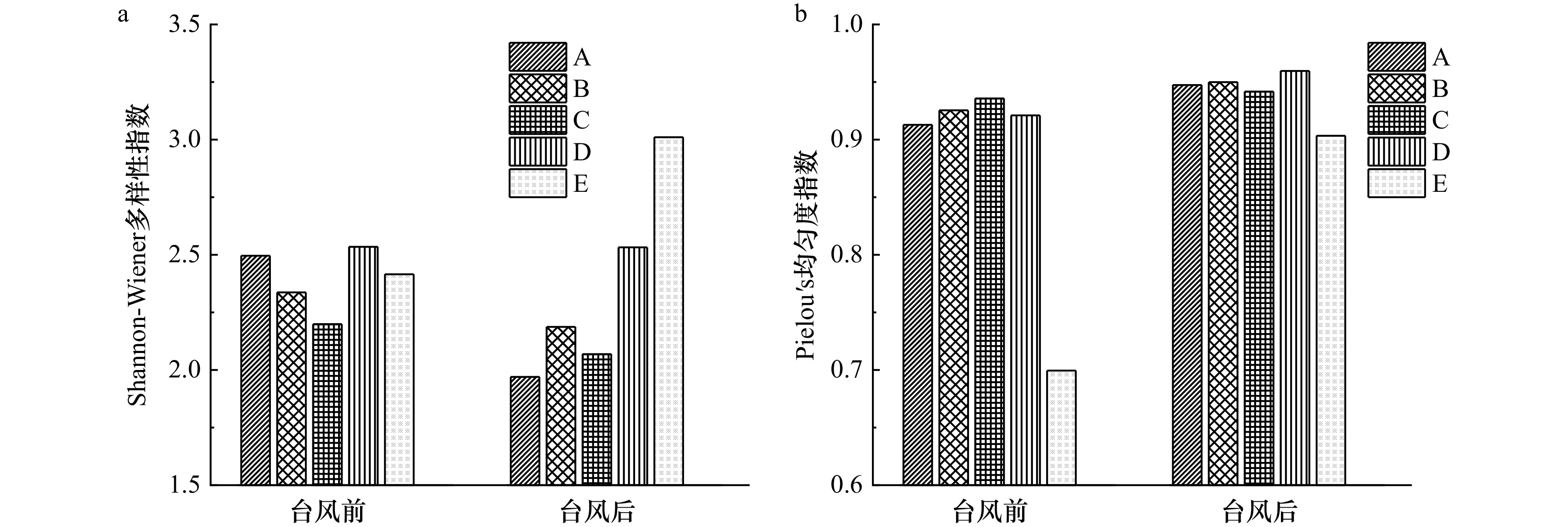
Studying the occurrence and dynamics of microplastics on coastal beaches is crucial for the integrated management of coastal zones and the assessment of ecological risks. Previous research has highlighted that physical processes play a pivotal role in influencing the occurrences of microplastic on coastal beaches. However, the impact of extreme meteorological events such as typhoons on the distribution of microplastic pollution has yet to be explored. This study conducted field fixed-plot experiments on the coastal beaches of Xiamen City before and after Typhoon "Haikui" to analyze the variations in the abundance, composition, and diversity of microplastic on beaches. The results showed that the abundance of microplastics on the beaches in Xiamen City before Typhoon Haikui was (251.5 ± 27.9) n/kg, and this value significantly decreased to (127.0 ± 18.8) n/kg post-typhoon. Before and after the typhoon, the composition of microplastics on the beaches showed distinct variations, with the abundance of microplastics of different shapes and sizes responding differently to the typhoon. In particular, the abundance of smaller particles (<500 μm) significantly decreased, while the proportion of fibrous particles increased. Moreover, the typhoon event led to a general decrease in the Shannon-Wiener diversity index, while an increase in the Pielou’s evenness index. The impact of typhoons on the distribution of microplastics on beaches arises from the complex coupling of multiple dynamic physical processes in extreme weather, and it is also closely related to factors such as the location and substrate conditions of the coasts. To achieve simulation and prediction of the dynamics of microplastic pollution during typhoon processes, systematic and comprehensive research on the relevant mechanisms is still required in the future.
Studying the occurrence and dynamics of microplastics on coastal beaches is crucial for the integrated management of coastal zones and the assessment of ecological risks. Previous research has highlighted that physical processes play a pivotal role in influencing the occurrences of microplastic on coastal beaches. However, the impact of extreme meteorological events such as typhoons on the distribution of microplastic pollution has yet to be explored. This study conducted field fixed-plot experiments on the coastal beaches of Xiamen City before and after Typhoon "Haikui" to analyze the variations in the abundance, composition, and diversity of microplastic on beaches. The results showed that the abundance of microplastics on the beaches in Xiamen City before Typhoon Haikui was (251.5 ± 27.9) n/kg, and this value significantly decreased to (127.0 ± 18.8) n/kg post-typhoon. Before and after the typhoon, the composition of microplastics on the beaches showed distinct variations, with the abundance of microplastics of different shapes and sizes responding differently to the typhoon. In particular, the abundance of smaller particles (<500 μm) significantly decreased, while the proportion of fibrous particles increased. Moreover, the typhoon event led to a general decrease in the Shannon-Wiener diversity index, while an increase in the Pielou’s evenness index. The impact of typhoons on the distribution of microplastics on beaches arises from the complex coupling of multiple dynamic physical processes in extreme weather, and it is also closely related to factors such as the location and substrate conditions of the coasts. To achieve simulation and prediction of the dynamics of microplastic pollution during typhoon processes, systematic and comprehensive research on the relevant mechanisms is still required in the future.


, Available online
Abstract:
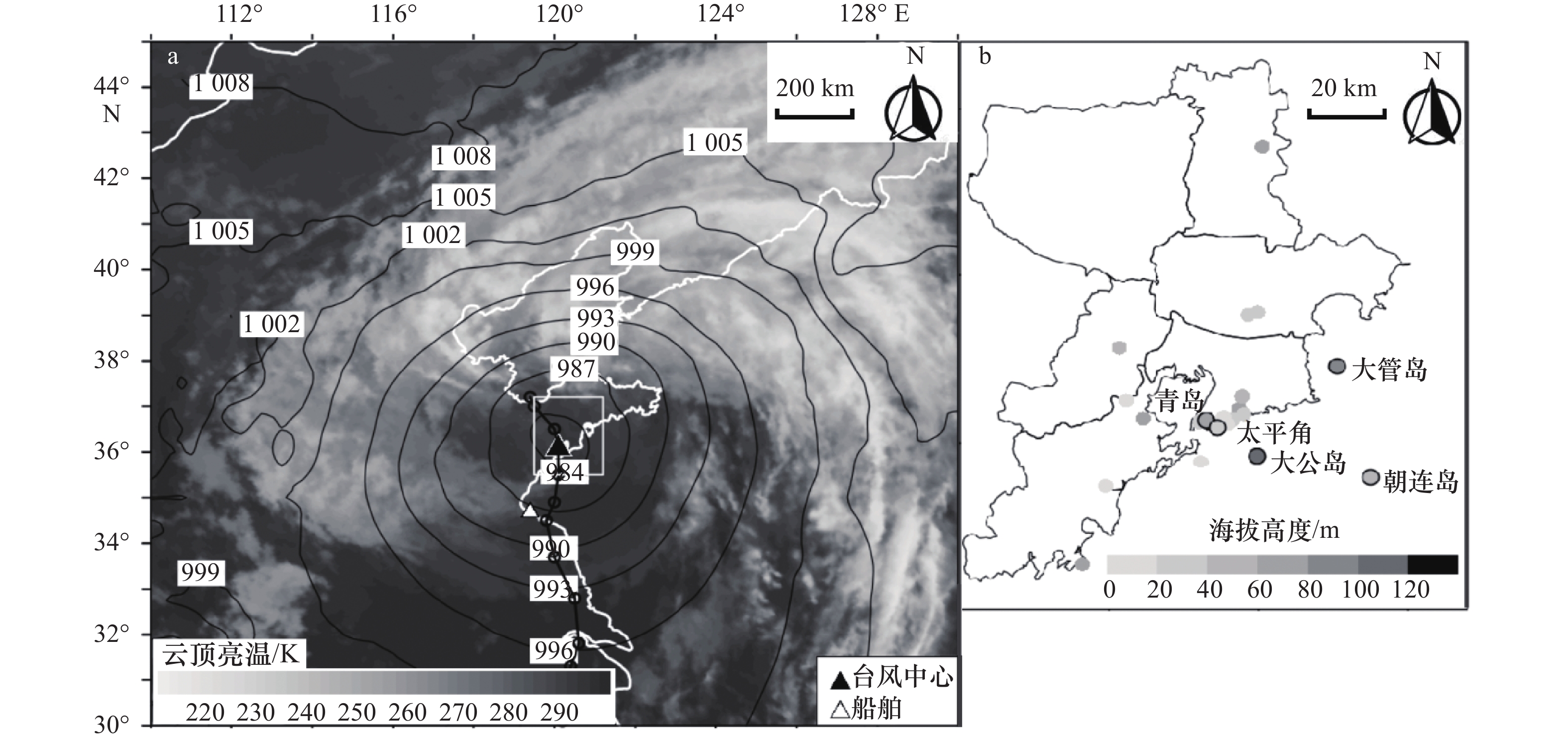
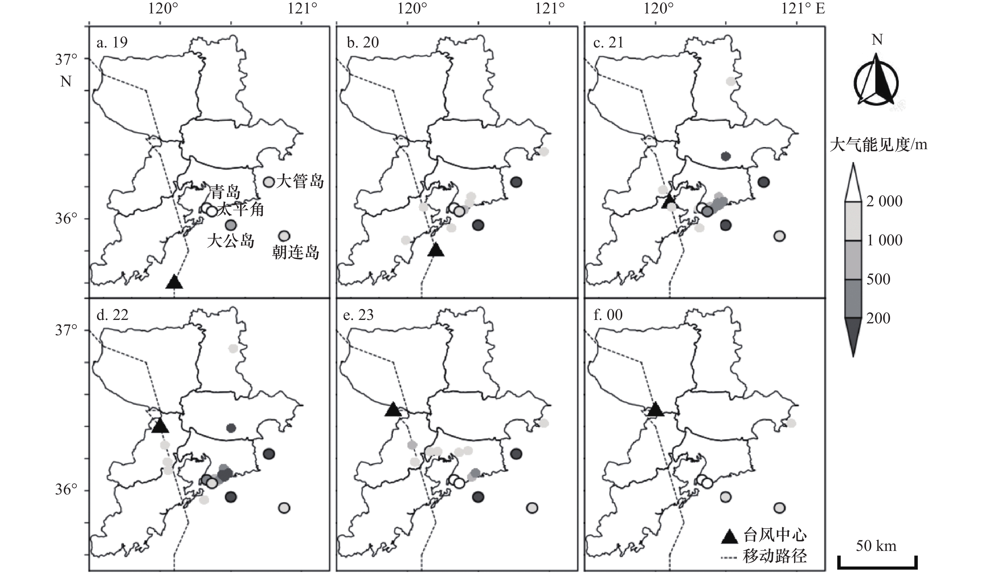
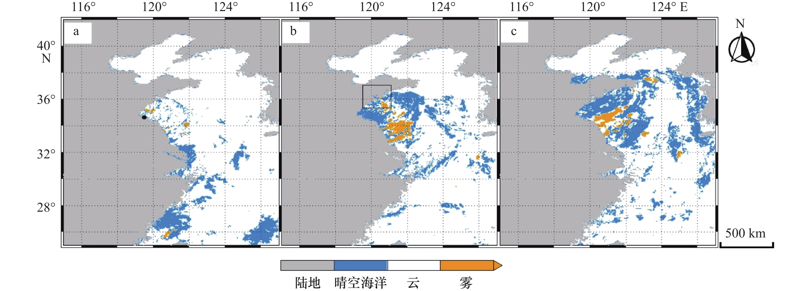
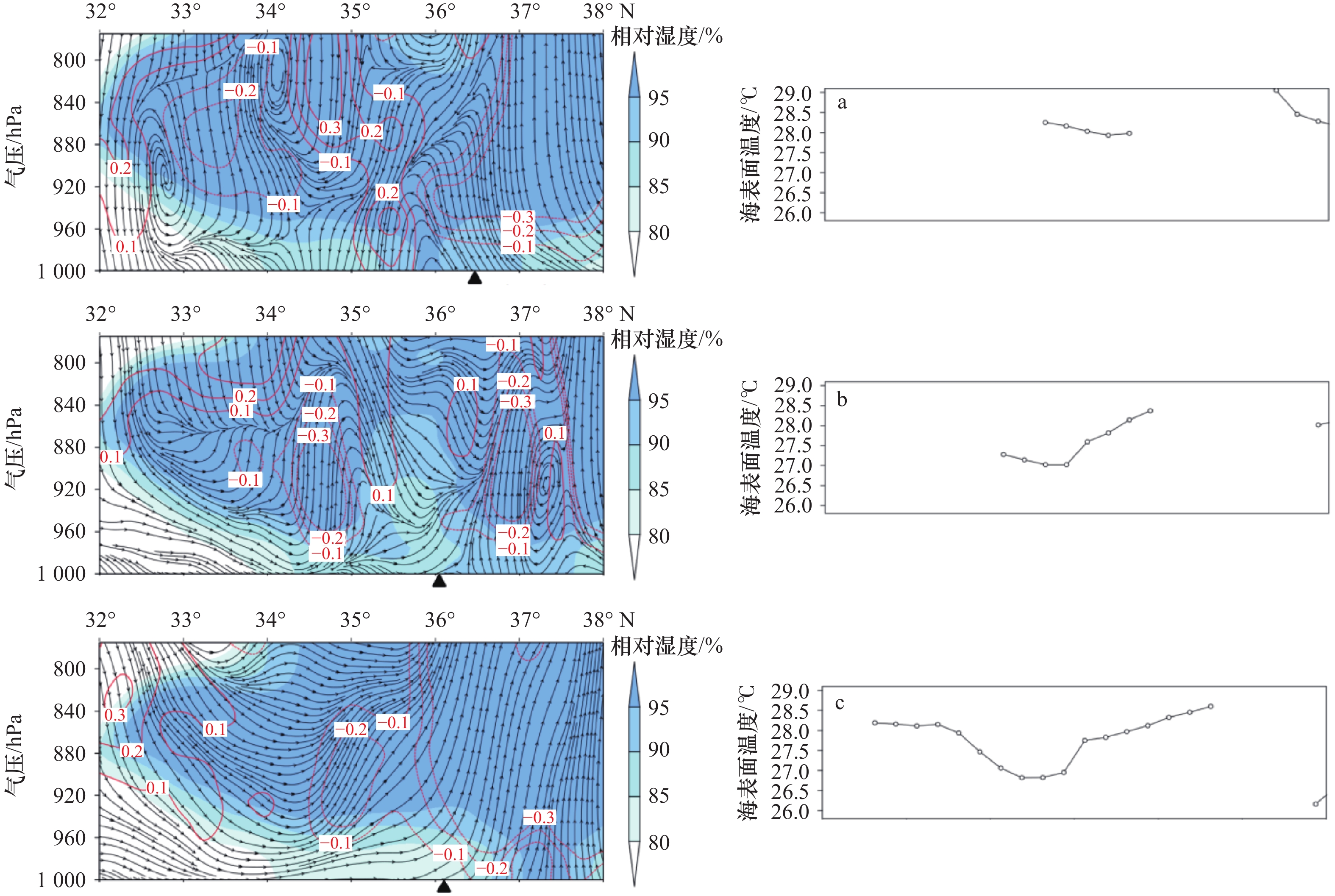
This study focuses on the physical process of a sea fog event during Typhoon Lekima in the Northern Yellow Sea by using observation data, reanalysis data and backward trajectory model. The analysis indicates that the typhoon circulation was the decisive factor determining whether fog formed offshore and developed inland. The warm and humid southerlies from the south Yellow Sea condensed into fog on the colder sea surface besides the typhoon center, which not only provided sufficient moisture for the formation and development of the sea fog but also formed a significant inversion layer over the fog area with the downdraft in the center of the typhoon. The "stable up and turbulent down" structure in the atmospheric boundary layer improved the development of sea fog on the coast and inland area. However, the horizontal wind steering and the strengthening wind speed behind the typhoon strengthened the wind shear in the atmospheric boundary layer, resulting in the enhanced turbulent mixing and the decrease of the stability in the bottom atmospheric boundary layer, which was the main cause of the fog dissipation.
This study focuses on the physical process of a sea fog event during Typhoon Lekima in the Northern Yellow Sea by using observation data, reanalysis data and backward trajectory model. The analysis indicates that the typhoon circulation was the decisive factor determining whether fog formed offshore and developed inland. The warm and humid southerlies from the south Yellow Sea condensed into fog on the colder sea surface besides the typhoon center, which not only provided sufficient moisture for the formation and development of the sea fog but also formed a significant inversion layer over the fog area with the downdraft in the center of the typhoon. The "stable up and turbulent down" structure in the atmospheric boundary layer improved the development of sea fog on the coast and inland area. However, the horizontal wind steering and the strengthening wind speed behind the typhoon strengthened the wind shear in the atmospheric boundary layer, resulting in the enhanced turbulent mixing and the decrease of the stability in the bottom atmospheric boundary layer, which was the main cause of the fog dissipation.


, Available online
Abstract:
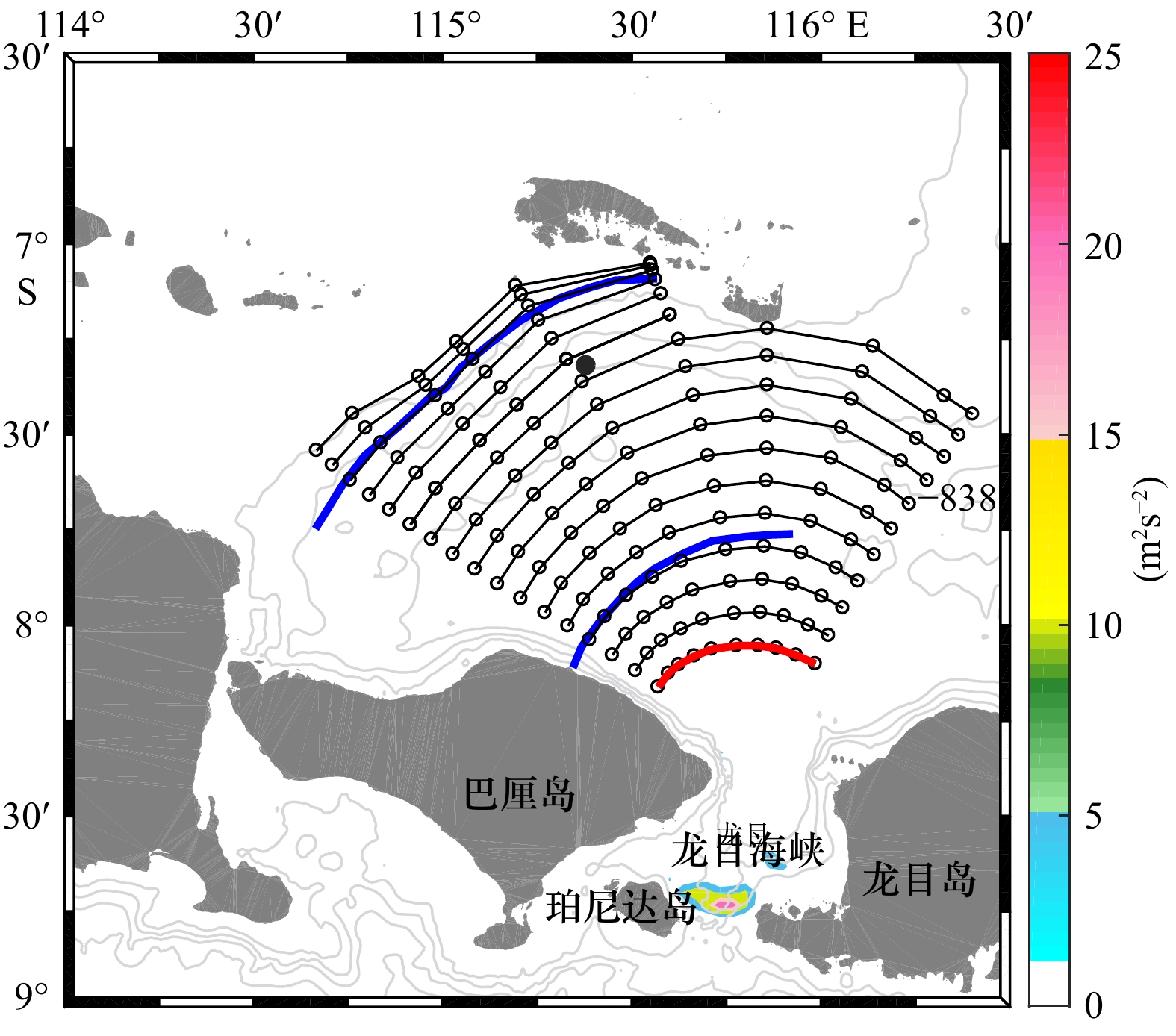
The possibility of the Indonesian submarine wreck on 20 April 2021 was analyzed based on satellite remote sensing observation and numerical simulation. The results indicate that large-amplitude oceanic internal waves, estimated to be approximately 50 m using satellite images, originate from the Lombok Strait. They are widely distributed to the north of the Bali Island and are suggested to cause an abrupt sinking of the Indonesian submarine.
The possibility of the Indonesian submarine wreck on 20 April 2021 was analyzed based on satellite remote sensing observation and numerical simulation. The results indicate that large-amplitude oceanic internal waves, estimated to be approximately 50 m using satellite images, originate from the Lombok Strait. They are widely distributed to the north of the Bali Island and are suggested to cause an abrupt sinking of the Indonesian submarine.

, Available online
Abstract:
Abstract:The potential fish production was controlled largely by ocean primary production (OPP) and there were a lot of research findings of estimating fish production by using OPP in China. The relationships between the biomass of fishery stock and OPP were often complicated by the varieties of trophic control in the ecosystem. In this paper, we examined the relationship between biomass of chub mackerel (Scomber japonicus) and net primary production (NPP) and discussed mechanism of trophic control in the ecosystem of chub mackerel fishing ground in south East China Sea by using catch and effort data from the large purse sense of China fishery and NPP derived from remote sensing. The results showed there was a significant non-linear relationship between NPP and standardized CPUE (Catch Per Unit Effort) (P<0.05) instead of the linear trend. The non-linear relationship could be described by a reversed parabolic curve, which meant the biomass of chub mackerel increased with NPP and then decreased when the NPP exceeded a point. The results implied there were other trophic controls in addition to bottom-up control occurred in the ecosystem in south East China Sea. We speculated the change of abundance of the key species at intermediate trophic levels or/and interspecific competitions contribute to the relationship.
Abstract:The potential fish production was controlled largely by ocean primary production (OPP) and there were a lot of research findings of estimating fish production by using OPP in China. The relationships between the biomass of fishery stock and OPP were often complicated by the varieties of trophic control in the ecosystem. In this paper, we examined the relationship between biomass of chub mackerel (Scomber japonicus) and net primary production (NPP) and discussed mechanism of trophic control in the ecosystem of chub mackerel fishing ground in south East China Sea by using catch and effort data from the large purse sense of China fishery and NPP derived from remote sensing. The results showed there was a significant non-linear relationship between NPP and standardized CPUE (Catch Per Unit Effort) (P<0.05) instead of the linear trend. The non-linear relationship could be described by a reversed parabolic curve, which meant the biomass of chub mackerel increased with NPP and then decreased when the NPP exceeded a point. The results implied there were other trophic controls in addition to bottom-up control occurred in the ecosystem in south East China Sea. We speculated the change of abundance of the key species at intermediate trophic levels or/and interspecific competitions contribute to the relationship.
Display Method:
2026, 48(3): 1-18.
doi: 10.12284/hyxb2026014
Abstract:
Developing plans for marine protected areas and predicting future changes in marine ecosystems require improved understanding of the response of marine lower trophic levels to environmental changes. For this purpose, numerical models are useful tools while they require continual improvement because of the inclusion of multiple parameters. This study focuses on development and evaluation of a high-resolution three-dimensional coupled ocean, sea-ice and ecosystem model for the Ross Sea (abbr. ROSE). Based on learnings from reviewing the previously developed marine ecosystem models covering the Ross Sea, ROSE is developed using version 3.6 of the Nucleus for European Modeling of the Ocean, version 3 of the Louvain-la-Neuve Sea Ice Model, and the Pelagic Interactions Scheme for Carbon and Ecosystem Study (volume 2). A series tuning of the parameters related to ice dynamics has been carried out. The results suggest that tuning the ice-ocean drag coefficient leads to improved simulation of the coastal polynya, which is a distinct feature in the Ross Sea. A decade-long hindcast simulation, covering 2010–2020, is achieved. The simulated space-time variations of sea ice, ocean hydrography, dissolved iron and Chl a mass concentrations are evaluated against available observations and previously published results. The evaluation results suggest that ROSE possesses reasonable skills in reproducing the known features of the above state variables and thus can be further applied to study the mechanism driving recent environmental changes and the response of lower trophic levels in the Ross Sea ecosystem.
Developing plans for marine protected areas and predicting future changes in marine ecosystems require improved understanding of the response of marine lower trophic levels to environmental changes. For this purpose, numerical models are useful tools while they require continual improvement because of the inclusion of multiple parameters. This study focuses on development and evaluation of a high-resolution three-dimensional coupled ocean, sea-ice and ecosystem model for the Ross Sea (abbr. ROSE). Based on learnings from reviewing the previously developed marine ecosystem models covering the Ross Sea, ROSE is developed using version 3.6 of the Nucleus for European Modeling of the Ocean, version 3 of the Louvain-la-Neuve Sea Ice Model, and the Pelagic Interactions Scheme for Carbon and Ecosystem Study (volume 2). A series tuning of the parameters related to ice dynamics has been carried out. The results suggest that tuning the ice-ocean drag coefficient leads to improved simulation of the coastal polynya, which is a distinct feature in the Ross Sea. A decade-long hindcast simulation, covering 2010–2020, is achieved. The simulated space-time variations of sea ice, ocean hydrography, dissolved iron and Chl a mass concentrations are evaluated against available observations and previously published results. The evaluation results suggest that ROSE possesses reasonable skills in reproducing the known features of the above state variables and thus can be further applied to study the mechanism driving recent environmental changes and the response of lower trophic levels in the Ross Sea ecosystem.


2026, 48(3): 19-30.
doi: 10.12284/hyxb2026032
Abstract:
High-stability monitoring of air-sea CO2 partial pressure (pCO2) is fundamental for assessing air-sea CO2 fluxes across long temporal and broad spatial scales. Among the commonly used methods worldwide, the air-water equilibration technique and the membrane-based diffusion technique are widely applied for measuring pCO2. In this study, we conducted underway continuous observations in Yueqing Bay and a 50-hour fixed-point deployment near Bianmanyu Island using the LI-COR® LI-5405A (air-water equilibration method) and the CONTROS HydroC® CO2 sensor (membrane equilibration method). The performance characteristics and application scenarios of the two approaches were systematically compared. The average difference between the two methods was 0.76 ± 4.46 μatm during the entire observation period, but both approaches produced consistent temporal trends with strong correlation. These two approaches exhibited distinct advantages: the membrane equilibrium method features low power consumption and an integrated watertight design, making it suitable for long-term continuous monitoring in in-situ scenarios or where power supply and space are limited. The air-water equilibration method, featuring rapid response and high precision, is more applicable for high-resolution measurements in dynamic environments. We propose a synergistic observational framework combining baseline monitoring using the membrane equilibration technique with periodic calibration via the air-water equilibration method. This integrated approach enhances both temporal and spatial resolution of air-sea CO2 flux observations, thereby improving data reliability and providing robust technical support for nearshore carbon source-sink assessments.
High-stability monitoring of air-sea CO2 partial pressure (pCO2) is fundamental for assessing air-sea CO2 fluxes across long temporal and broad spatial scales. Among the commonly used methods worldwide, the air-water equilibration technique and the membrane-based diffusion technique are widely applied for measuring pCO2. In this study, we conducted underway continuous observations in Yueqing Bay and a 50-hour fixed-point deployment near Bianmanyu Island using the LI-COR® LI-5405A (air-water equilibration method) and the CONTROS HydroC® CO2 sensor (membrane equilibration method). The performance characteristics and application scenarios of the two approaches were systematically compared. The average difference between the two methods was 0.76 ± 4.46 μatm during the entire observation period, but both approaches produced consistent temporal trends with strong correlation. These two approaches exhibited distinct advantages: the membrane equilibrium method features low power consumption and an integrated watertight design, making it suitable for long-term continuous monitoring in in-situ scenarios or where power supply and space are limited. The air-water equilibration method, featuring rapid response and high precision, is more applicable for high-resolution measurements in dynamic environments. We propose a synergistic observational framework combining baseline monitoring using the membrane equilibration technique with periodic calibration via the air-water equilibration method. This integrated approach enhances both temporal and spatial resolution of air-sea CO2 flux observations, thereby improving data reliability and providing robust technical support for nearshore carbon source-sink assessments.


2026, 48(3): 31-44.
doi: 10.12284/hyxb2026030
Abstract:
This study examines the mechanism of the unexpected absence of bottom hypoxia in the lower Zhujiang River Estuary during summer 2023 through integrated analysis of hydrological, biogeochemical and physical drivers. The Zhujiang River discharge during 2023 summer was only 51% of the historical summer average. This led to a 45% reduction in riverine nutrient fluxes and a sharp decline in marine-sourced organic carbon production. Persistent northeasterly downwelling-favorable winds during the 15 days preceding sampling weakened stratification (stratification factor of 0.074 ± 0.20 during 2023 cruise versus 0.14 ± 0.17, 0.38 ± 0.50 and 0.18 ± 0.20 during other three cruises of 2015, 2017 and 2018 when hypoxia occurred) enhanced vertical mixing and oxygen replenishment in the bottom water. The reduced river discharge also shortened the water residence time in the estuary to 1.8 days, compared to 3.1 days under average summer discharge conditions, thereby limiting the oxygen-depleting effect of organic matter degradation. The synergistic effect of these factors led to the absence of bottom-water hypoxia in the Zhujiang River Estuary in summer 2023. This study reveals the important regulating role of extreme hydro-meteorological conditions in the formation of estuarine hypoxia.
This study examines the mechanism of the unexpected absence of bottom hypoxia in the lower Zhujiang River Estuary during summer 2023 through integrated analysis of hydrological, biogeochemical and physical drivers. The Zhujiang River discharge during 2023 summer was only 51% of the historical summer average. This led to a 45% reduction in riverine nutrient fluxes and a sharp decline in marine-sourced organic carbon production. Persistent northeasterly downwelling-favorable winds during the 15 days preceding sampling weakened stratification (stratification factor of 0.074 ± 0.20 during 2023 cruise versus 0.14 ± 0.17, 0.38 ± 0.50 and 0.18 ± 0.20 during other three cruises of 2015, 2017 and 2018 when hypoxia occurred) enhanced vertical mixing and oxygen replenishment in the bottom water. The reduced river discharge also shortened the water residence time in the estuary to 1.8 days, compared to 3.1 days under average summer discharge conditions, thereby limiting the oxygen-depleting effect of organic matter degradation. The synergistic effect of these factors led to the absence of bottom-water hypoxia in the Zhujiang River Estuary in summer 2023. This study reveals the important regulating role of extreme hydro-meteorological conditions in the formation of estuarine hypoxia.


2026, 48(3): 45-58.
doi: 10.12284/hyxb2026034
Abstract:
To overcome key challenges such as the tendency of seeds to drift with water currents during sowing and low seedling establishment rates, this study focused on eelgrass (Zostera marina), a dominant temperate seagrass species. The effects of two types of pelleting matrices—wood-based and mineral-based—and varying drying durations (0–12 min) on the physical and physiological properties of eelgrass seeds were systematically investigated. Following a preliminary screening of groups exhibiting germination potential, the impacts of these treatments on seed germination and seedling establishment were further evaluated. Results demonstrated that prolonged drying significantly enhanced both sinking acceleration and compressive strength of granulated seeds. Notably, seeds coated with the mineral-based matrix exhibited the highest sinking acceleration, reaching 3.2 times that of uncoated seeds, and displayed 3.1 times greater compressive strength than those in the wood-based matrix group. However, seed viability decreased progressively with increasing drying time: the uncoated and wood-based matrix groups maintained viability above 80% up to 8 min of drying, whereas the mineral-based group fell below this threshold after only 4 min. The wood-based matrix played a protective role in alleviating physiological stress induced by drying. Throughout the 0–12 min drying period, α-/β-amylase activities and total protein content in the wood-based matrix group remained comparable to those in the uncoated control group and were significantly higher than those in the mineral-based matrix group (p < 0.05). With respect to seedling establishment, the wood-based matrix treatment achieved rates of 39.0%–43.0% under drying durations of 0–4 min, which were statistically similar to the uncoated control (42.0%) and markedly higher than those observed in the mineral-based treatment (8%–12.5%). Correlation analysis revealed a highly significant positive association between seedling establishment rate and key physiological parameters, including enzyme activity and protein content. Furthermore, comprehensive benefit index analysis indicated that the wood-based matrix could achieve an optimal trade-off between physical suitability and physiological vitality when drying duration was restricted to 2–4 min. These findings suggest that using a wood-based pelleting matrix combined with a short drying duration (2–4 min) is a feasible and effective strategy for improving Z. marina seed handling and establishment in seagrass restoration practices.
To overcome key challenges such as the tendency of seeds to drift with water currents during sowing and low seedling establishment rates, this study focused on eelgrass (Zostera marina), a dominant temperate seagrass species. The effects of two types of pelleting matrices—wood-based and mineral-based—and varying drying durations (0–12 min) on the physical and physiological properties of eelgrass seeds were systematically investigated. Following a preliminary screening of groups exhibiting germination potential, the impacts of these treatments on seed germination and seedling establishment were further evaluated. Results demonstrated that prolonged drying significantly enhanced both sinking acceleration and compressive strength of granulated seeds. Notably, seeds coated with the mineral-based matrix exhibited the highest sinking acceleration, reaching 3.2 times that of uncoated seeds, and displayed 3.1 times greater compressive strength than those in the wood-based matrix group. However, seed viability decreased progressively with increasing drying time: the uncoated and wood-based matrix groups maintained viability above 80% up to 8 min of drying, whereas the mineral-based group fell below this threshold after only 4 min. The wood-based matrix played a protective role in alleviating physiological stress induced by drying. Throughout the 0–12 min drying period, α-/β-amylase activities and total protein content in the wood-based matrix group remained comparable to those in the uncoated control group and were significantly higher than those in the mineral-based matrix group (p < 0.05). With respect to seedling establishment, the wood-based matrix treatment achieved rates of 39.0%–43.0% under drying durations of 0–4 min, which were statistically similar to the uncoated control (42.0%) and markedly higher than those observed in the mineral-based treatment (8%–12.5%). Correlation analysis revealed a highly significant positive association between seedling establishment rate and key physiological parameters, including enzyme activity and protein content. Furthermore, comprehensive benefit index analysis indicated that the wood-based matrix could achieve an optimal trade-off between physical suitability and physiological vitality when drying duration was restricted to 2–4 min. These findings suggest that using a wood-based pelleting matrix combined with a short drying duration (2–4 min) is a feasible and effective strategy for improving Z. marina seed handling and establishment in seagrass restoration practices.


2026, 48(3): 59-71.
doi: 10.12284/hyxb2026012
Abstract:
Toxic algal species pose significant threats to ecological environmental safety and human health. Azadinium dexteroporum, one of the main producers of azaspiracid toxins, remains poorly studied in China, and its distribution in Chinese coastal waters is still unclear. In this study, environmental DNA (eDNA) methods were used to obtain occurrence records of A. dexteroporum in Chinese coastal areas. Using the 2050s and 2100s as future projection periods, the Maximum Entropy (MaxEnt)model was applied to simulate the potential suitable habitats of this species under current and three future climate scenarios (SSP126, SSP245, and SSP585). The results indicated that nitrate concentration, silicate concentration, and sea surface temperature were the primary environmental factors influencing the distribution of A. dexteroporum. Under current conditions, the suitable habitat area was estimated to be 63.71 × 10⁴ km2, mainly concentrated in the northern South China Sea. With climate change, the potential suitable area of A. dexteroporum is projected to shrink, decreasing to 5.58×10⁴−32.21×10⁴ km2 by the 2100s. The spatial distribution pattern of suitable habitats shows an overall “southward contraction and northward expansion” trend: the extensive suitable areas in the South China Sea are expected to disappear, while new suitable areas may emerge in the Yellow and Bohai seas. The centroid of suitable habitats is projected to shift up to1439 km, migrating from the northern South China Sea to north of the Changjiang River Estuary. These findings provide important scientific insights for the ecological risk monitoring, forecasting, and management of harmful dinoflagellates.
Toxic algal species pose significant threats to ecological environmental safety and human health. Azadinium dexteroporum, one of the main producers of azaspiracid toxins, remains poorly studied in China, and its distribution in Chinese coastal waters is still unclear. In this study, environmental DNA (eDNA) methods were used to obtain occurrence records of A. dexteroporum in Chinese coastal areas. Using the 2050s and 2100s as future projection periods, the Maximum Entropy (MaxEnt)model was applied to simulate the potential suitable habitats of this species under current and three future climate scenarios (SSP126, SSP245, and SSP585). The results indicated that nitrate concentration, silicate concentration, and sea surface temperature were the primary environmental factors influencing the distribution of A. dexteroporum. Under current conditions, the suitable habitat area was estimated to be 63.71 × 10⁴ km2, mainly concentrated in the northern South China Sea. With climate change, the potential suitable area of A. dexteroporum is projected to shrink, decreasing to 5.58×10⁴−32.21×10⁴ km2 by the 2100s. The spatial distribution pattern of suitable habitats shows an overall “southward contraction and northward expansion” trend: the extensive suitable areas in the South China Sea are expected to disappear, while new suitable areas may emerge in the Yellow and Bohai seas. The centroid of suitable habitats is projected to shift up to


2026, 48(3): 72-83.
doi: 10.12284/hyxb2026026
Abstract:
The Miaodao Archipelago in Shandong Province are rich in seaweed resources and hold great potential for nearshore marine carbon sinks. However, fundamental data and research related to the seaweed beds in this region remain scarce, which astricts the calculation and evaluation to carbon sink of seaweed beds. Therefore, this study aimed to complement the gap in baseline information regarding seaweed beds in the Miaodao Archipelago. In this study, 10 residential islands of Miaodao archipelago in Shandong Province were selected and the distribution of seaweed fields in the subtidal zone was investigated and sampled by scuba diving. Seaweed resource information in the seaweed beds, including the distribution and area of seaweed beds, species composition, biomass, dominant species, and community diversity, was identified and counted, and then combined with the environmental context, the community structure characteristics of the seaweed beds in the 10 islands were clustered. A total of 34 species of macroalgae were collected, belonging to 21 families and 25 genera. Among them were 18 species of red algae (11 families, 15 genera), 4 species of green algae (2 families, 2 genera), and 12 species of brown algae (8 families, 8 genera). The dominant macroalgal species in the region included Saccharina japonica, Undaria pinnatifida, Sargassum muticum, Gelidium amansii, Chondrus nipponicus, Ulva lactuca, Dictyopteris divaricata, Sargassum pallidum, and Desmarestia viridis. The results of statistical analysis revealed that Tuoji Island and Xiaoqin Island had relatively high biomass density. Nouth Changshan Island exhibited the highest species richness, followed by Miao Island and South Huangcheng Island. South Huangcheng Island had the highest diversity index, with Nouth Changshan Island and Tuoji Island ranking next, and also showed the highest evenness index among the surveyed sites. Cluster analysis results indicated significant differences in community structure between the five southern islands (South Changshan Island, North Changshan Island, Miaodao Island, Daheishan Island, Xiaoheishan Island) and the five northern islands (Tuoji Island, Daqin Island, Xiaoqin Island, South Huangcheng Island, North Huangcheng Island), mainly due to geographic variation. This study helps complement the gap in baseline information regarding seaweed beds in Shandong Province, thus providing essential data for the carbon sink evaluation and theoretical support for development of nearshore blue carbon sink of seaweed beds in Shandong Province.
The Miaodao Archipelago in Shandong Province are rich in seaweed resources and hold great potential for nearshore marine carbon sinks. However, fundamental data and research related to the seaweed beds in this region remain scarce, which astricts the calculation and evaluation to carbon sink of seaweed beds. Therefore, this study aimed to complement the gap in baseline information regarding seaweed beds in the Miaodao Archipelago. In this study, 10 residential islands of Miaodao archipelago in Shandong Province were selected and the distribution of seaweed fields in the subtidal zone was investigated and sampled by scuba diving. Seaweed resource information in the seaweed beds, including the distribution and area of seaweed beds, species composition, biomass, dominant species, and community diversity, was identified and counted, and then combined with the environmental context, the community structure characteristics of the seaweed beds in the 10 islands were clustered. A total of 34 species of macroalgae were collected, belonging to 21 families and 25 genera. Among them were 18 species of red algae (11 families, 15 genera), 4 species of green algae (2 families, 2 genera), and 12 species of brown algae (8 families, 8 genera). The dominant macroalgal species in the region included Saccharina japonica, Undaria pinnatifida, Sargassum muticum, Gelidium amansii, Chondrus nipponicus, Ulva lactuca, Dictyopteris divaricata, Sargassum pallidum, and Desmarestia viridis. The results of statistical analysis revealed that Tuoji Island and Xiaoqin Island had relatively high biomass density. Nouth Changshan Island exhibited the highest species richness, followed by Miao Island and South Huangcheng Island. South Huangcheng Island had the highest diversity index, with Nouth Changshan Island and Tuoji Island ranking next, and also showed the highest evenness index among the surveyed sites. Cluster analysis results indicated significant differences in community structure between the five southern islands (South Changshan Island, North Changshan Island, Miaodao Island, Daheishan Island, Xiaoheishan Island) and the five northern islands (Tuoji Island, Daqin Island, Xiaoqin Island, South Huangcheng Island, North Huangcheng Island), mainly due to geographic variation. This study helps complement the gap in baseline information regarding seaweed beds in Shandong Province, thus providing essential data for the carbon sink evaluation and theoretical support for development of nearshore blue carbon sink of seaweed beds in Shandong Province.


2026, 48(3): 84-97.
doi: 10.12284/hyxb2026036
Abstract:
The mantle tissue and its mucus of the hard clam Meretrix meretrix play a significant role in defending against pathogens. However, the potential links between the composition and function of their inherent microbiota and host immunity remains unclear. In this study, 16S rRNA gene high-throughput sequencing was used to compare the microbiota composition and potential functions between the mantle tissue (group M) and mantle mucus (group N) in health clams. Non-targeted metabolomics (UHPLC-Q-TOF/MS) was employed to analyze metabolite changes in the mantle mucus under Vibrio stress. Furthermore, spearman correlation analysis was applied to integrate the microbiota and metabolomics data, aiming to preliminarily explore potential associations between the microbiota and host immune metabolism. The results revealed significant niche differentiation between the mantle and mucus microbiota. The mantle microbiota exhibited higher richness and was dominated by the phylum Spirochaetota, while the mucus microbiota showed higher evenness, with Proteobacteria and Bacteroidota as the dominant phyla. The mucus was significantly enriched in taxa with polysaccharide-degrading or potential pathogenic capabilities, such as the genera Vibrio, Tenacibaculum and Flavobacterium. Functional prediction indicated that the mucus microbiota was more active in immune- and energy-related pathways, like cysteine and methionine metabolism and oxidative phosphorylation. Metabolomic analysis under Vibrio stress showed significant alterations in various immune-related metabolites in the mucus, including succinate acid, propionate acid, and phenylalanine. Correlation analysis between microbiota and metabolites revealed close associations between resident microbes and host metabolites, such as a strong positive correlation between the genus Marinomonas and uracil, and a strong negative correlation between Flavobacterium and nitrate. Collectively, these findings suggest that the mantle-mucus complex functions as a dynamic interfacial microenvironment. Its specific microbial community structure may interact with host metabolism, providing immunological preparedness for the host to counteract pathogen invasion.
The mantle tissue and its mucus of the hard clam Meretrix meretrix play a significant role in defending against pathogens. However, the potential links between the composition and function of their inherent microbiota and host immunity remains unclear. In this study, 16S rRNA gene high-throughput sequencing was used to compare the microbiota composition and potential functions between the mantle tissue (group M) and mantle mucus (group N) in health clams. Non-targeted metabolomics (UHPLC-Q-TOF/MS) was employed to analyze metabolite changes in the mantle mucus under Vibrio stress. Furthermore, spearman correlation analysis was applied to integrate the microbiota and metabolomics data, aiming to preliminarily explore potential associations between the microbiota and host immune metabolism. The results revealed significant niche differentiation between the mantle and mucus microbiota. The mantle microbiota exhibited higher richness and was dominated by the phylum Spirochaetota, while the mucus microbiota showed higher evenness, with Proteobacteria and Bacteroidota as the dominant phyla. The mucus was significantly enriched in taxa with polysaccharide-degrading or potential pathogenic capabilities, such as the genera Vibrio, Tenacibaculum and Flavobacterium. Functional prediction indicated that the mucus microbiota was more active in immune- and energy-related pathways, like cysteine and methionine metabolism and oxidative phosphorylation. Metabolomic analysis under Vibrio stress showed significant alterations in various immune-related metabolites in the mucus, including succinate acid, propionate acid, and phenylalanine. Correlation analysis between microbiota and metabolites revealed close associations between resident microbes and host metabolites, such as a strong positive correlation between the genus Marinomonas and uracil, and a strong negative correlation between Flavobacterium and nitrate. Collectively, these findings suggest that the mantle-mucus complex functions as a dynamic interfacial microenvironment. Its specific microbial community structure may interact with host metabolism, providing immunological preparedness for the host to counteract pathogen invasion.


2026, 48(3): 98-108.
doi: 10.12284/hyxb2026028
Abstract:
Artemia is important live bait in the cultivation of marine fish and crustacean seedlings, with more than 90% derived from wild Artemia resources. In order to study the effects of environmental changes and the unique aquaculture and harvest management on the morphometrical and genetic characteristics of Artemia in Yuncheng Salt Lake, Shanxi Province in the past 30 years, Artemia cysts collected in 1993 (YC-1993), 2019 (YC-2019) and 2023 (YC-2023) from Yuncheng Salt Lake were cultured and morphometrical measurements were conducted. Specific-locus amplified fragments sequencing (SLAF-seq) was used for population genetics analysis. The results showed that the YC-2023 group was extremely significantly larger than the YC-1993 group in terms of body length, abdominal length, ovary width, interocular distance, eye diameter, second antenna length, and peripheral claspers, while the cyst diameter of the YC-2023 group was significantly smaller than that of the YC-1993 group. The results of genetic analysis showed that the YC-2023 group had the lowest genetic diversity. The polymorphism information content (PIC) of three populations was between 0.252 and 0.305, showing moderate polymorphism (0.25 < PIC < 0.5). The Fst value of the genetic differentiation coefficient between the YC-2019 and YC-2023 populations is 0.087, indicating moderate genetic differentiation (0.05 < Fst < 0.15). However, the Fst value between the YC-1993 and the other two populations is 0.151, indicating a high degree of genetic differentiation (0.15 < Fst < 0.25). Phylogenetic tree, principal component analysis, the kinship heat map and Admixture analysis further revealed that although there was a certain degree of genetic differentiation among the three populations, their genetic information originated from the same original ancestor. The morphometrical traits and genetic variations of Yuncheng Artemia may result from genetic selection and genetic drift caused by the environmental changes that Yuncheng Salt Lake has undergone in recent years, and unique aquaculture and harvest management. This study will provide theoretical support for the conservation and utilization of Artemia germplasm resources in Yuncheng Salt Lake.
Artemia is important live bait in the cultivation of marine fish and crustacean seedlings, with more than 90% derived from wild Artemia resources. In order to study the effects of environmental changes and the unique aquaculture and harvest management on the morphometrical and genetic characteristics of Artemia in Yuncheng Salt Lake, Shanxi Province in the past 30 years, Artemia cysts collected in 1993 (YC-1993), 2019 (YC-2019) and 2023 (YC-2023) from Yuncheng Salt Lake were cultured and morphometrical measurements were conducted. Specific-locus amplified fragments sequencing (SLAF-seq) was used for population genetics analysis. The results showed that the YC-2023 group was extremely significantly larger than the YC-1993 group in terms of body length, abdominal length, ovary width, interocular distance, eye diameter, second antenna length, and peripheral claspers, while the cyst diameter of the YC-2023 group was significantly smaller than that of the YC-1993 group. The results of genetic analysis showed that the YC-2023 group had the lowest genetic diversity. The polymorphism information content (PIC) of three populations was between 0.252 and 0.305, showing moderate polymorphism (0.25 < PIC < 0.5). The Fst value of the genetic differentiation coefficient between the YC-2019 and YC-2023 populations is 0.087, indicating moderate genetic differentiation (0.05 < Fst < 0.15). However, the Fst value between the YC-1993 and the other two populations is 0.151, indicating a high degree of genetic differentiation (0.15 < Fst < 0.25). Phylogenetic tree, principal component analysis, the kinship heat map and Admixture analysis further revealed that although there was a certain degree of genetic differentiation among the three populations, their genetic information originated from the same original ancestor. The morphometrical traits and genetic variations of Yuncheng Artemia may result from genetic selection and genetic drift caused by the environmental changes that Yuncheng Salt Lake has undergone in recent years, and unique aquaculture and harvest management. This study will provide theoretical support for the conservation and utilization of Artemia germplasm resources in Yuncheng Salt Lake.


2026, 48(3): 109-121.
doi: 10.12284/hyxb2026038
Abstract:
Coral reef ecological restoration is internationally recognized as a pivotal technology and essential approach to reverse the degradation trend of coral reefs, which requires selecting native coral species for restoration and matched artificial reefs based on local conditions. Taking the degraded coral reef area of Weizhou Island, Guangxi as the research object, this study systematically investigated the growth adaptability of hermatypic stony corals and their compatibility with artificial reefs through a 10-month monitoring program of artificial nursery cultivation and an 18-month transplantation experiment involving three types of concrete artificial reefs (trapezoidal, table-shaped, and truncated conical). The results showed that the 10-month survival rates of all four tested coral species exceeded 85%. Both Acropora muricata and Acropora hyacinthus achieved 100% survival. Acropora hyacinthus exhibited a higher growth rate of living tissue projection area during some periods, while Acropora muricata performed better comprehensively in terms of survival stability, three-dimensional morphology formation, and engineering application potential, and can be used as the core restoration species. Among the three types of artificial reefs, the 18-month survival rate of corals on the trapezoidal artificial reef reached 92%, which was significantly higher than that on the truncated conical reef (77%) and the table-shaped reef (60%). Under environmental stress, physiological indicators including effective quantum yield and net photosynthetic rate showed significant specific responses to reef shapes, with the trapezoidal artificial reef demonstrating superior resistance to high temperature and typhoon stress as well as stronger damage recovery capability. The coral reef ecological restoration model established in this study—featuring Acropora muricata as the main restoration species, cable tie binding as the fixation method, metal seedbeds as the cultivation carrier, and trapezoidal artificial reefs as the colonization substrate—provides a scientific basis and practical technical reference for coral reef ecological restoration in typhoon-prone subtropical marine areas of China.
Coral reef ecological restoration is internationally recognized as a pivotal technology and essential approach to reverse the degradation trend of coral reefs, which requires selecting native coral species for restoration and matched artificial reefs based on local conditions. Taking the degraded coral reef area of Weizhou Island, Guangxi as the research object, this study systematically investigated the growth adaptability of hermatypic stony corals and their compatibility with artificial reefs through a 10-month monitoring program of artificial nursery cultivation and an 18-month transplantation experiment involving three types of concrete artificial reefs (trapezoidal, table-shaped, and truncated conical). The results showed that the 10-month survival rates of all four tested coral species exceeded 85%. Both Acropora muricata and Acropora hyacinthus achieved 100% survival. Acropora hyacinthus exhibited a higher growth rate of living tissue projection area during some periods, while Acropora muricata performed better comprehensively in terms of survival stability, three-dimensional morphology formation, and engineering application potential, and can be used as the core restoration species. Among the three types of artificial reefs, the 18-month survival rate of corals on the trapezoidal artificial reef reached 92%, which was significantly higher than that on the truncated conical reef (77%) and the table-shaped reef (60%). Under environmental stress, physiological indicators including effective quantum yield and net photosynthetic rate showed significant specific responses to reef shapes, with the trapezoidal artificial reef demonstrating superior resistance to high temperature and typhoon stress as well as stronger damage recovery capability. The coral reef ecological restoration model established in this study—featuring Acropora muricata as the main restoration species, cable tie binding as the fixation method, metal seedbeds as the cultivation carrier, and trapezoidal artificial reefs as the colonization substrate—provides a scientific basis and practical technical reference for coral reef ecological restoration in typhoon-prone subtropical marine areas of China.


2026, 48(3): 122-134.
doi: 10.12284/hyxb2026024
Abstract:
Taking the Caofeidian seagrass bed—the largest existing seagrass bed in China—as the research object, this study adopted a combined method of remote sensing interpretation, field investigation, and model analysis to carry out research on the quantitative zoning of density and the formation mechanism of spatial heterogeneity of the Caofeidian seagrass bed. Through the interpretation of high-resolution satellite remote sensing images and combined with on-site field verification, the quantitative data of three core zoning types under the spatial pattern of “dense in the north and sparse in the south” of the Caofeidian seagrass bed were obtained, namely the dense area (with an area of 11.13 km2, accounting for 26.03%), the moderately dense area (with an area of 15.06 km2, accounting for 35.23%), and the sparse area (with an area of 16.56 km2, accounting for 38.74%). On the whole, it shows the characteristics of patchy mosaic distribution. Based on 10 environmental data items (including illumination, ammonium, and sediment density) obtained from field investigations, an MLP-ANN (Multilayer Perceptron-Artificial Neural Network) model was used for analysis, and it was found that the internal friction angle of sediment (contribution: 18%), water temperature (contribution: 15%), and sediment phosphate (contribution: 15%) were the core driving factors affecting the density zoning of the seagrass bed, with a cumulative influence accounting for 48%. The research results indicated that the density zoning of the Caofeidian seagrass bed is formed by thejoint effect of natural dynamic factors and human activities: in the southern region, strong tidal currents cause sediment scouring, and superimposed on the impacts of engineering activities such as oilfield exploration and channel dredging, as well as land-based pollution, forming the degradation chain of “sediment disturbance - nutrient imbalance”; the northern region is far from these disturbance sources, and through ecological restoration, the sediment conditions have been optimized, thus providing support for the formation of the medium-to-high density seagrass bed areas. This study fills the gaps in the quantitative research on the density zoning of the Caofeidian seagrass bed and the research on its formation mechanism, and provides a scientific basis and technical paradigm for the scientific assessment and effective restoration of seagrass beds in the Bohai Bay.
Taking the Caofeidian seagrass bed—the largest existing seagrass bed in China—as the research object, this study adopted a combined method of remote sensing interpretation, field investigation, and model analysis to carry out research on the quantitative zoning of density and the formation mechanism of spatial heterogeneity of the Caofeidian seagrass bed. Through the interpretation of high-resolution satellite remote sensing images and combined with on-site field verification, the quantitative data of three core zoning types under the spatial pattern of “dense in the north and sparse in the south” of the Caofeidian seagrass bed were obtained, namely the dense area (with an area of 11.13 km2, accounting for 26.03%), the moderately dense area (with an area of 15.06 km2, accounting for 35.23%), and the sparse area (with an area of 16.56 km2, accounting for 38.74%). On the whole, it shows the characteristics of patchy mosaic distribution. Based on 10 environmental data items (including illumination, ammonium, and sediment density) obtained from field investigations, an MLP-ANN (Multilayer Perceptron-Artificial Neural Network) model was used for analysis, and it was found that the internal friction angle of sediment (contribution: 18%), water temperature (contribution: 15%), and sediment phosphate (contribution: 15%) were the core driving factors affecting the density zoning of the seagrass bed, with a cumulative influence accounting for 48%. The research results indicated that the density zoning of the Caofeidian seagrass bed is formed by thejoint effect of natural dynamic factors and human activities: in the southern region, strong tidal currents cause sediment scouring, and superimposed on the impacts of engineering activities such as oilfield exploration and channel dredging, as well as land-based pollution, forming the degradation chain of “sediment disturbance - nutrient imbalance”; the northern region is far from these disturbance sources, and through ecological restoration, the sediment conditions have been optimized, thus providing support for the formation of the medium-to-high density seagrass bed areas. This study fills the gaps in the quantitative research on the density zoning of the Caofeidian seagrass bed and the research on its formation mechanism, and provides a scientific basis and technical paradigm for the scientific assessment and effective restoration of seagrass beds in the Bohai Bay.


Most DownloadedMORE>
- Increased influences of the SST along the Kuroshio in previous winter on the summer precipitation in northeastern China
- The satellite remotely-sensed analysis of the temporal and spatial variability of chlorophyll a concentration in the northern South China Sea
- Observation of the seasonal evolution of DO, chlorophyll a maximum phenomena and nutrient accumulating in the southern Huanghai (Yellow) Sea Cold Water Mass area
- Quantitative research on earthquake-generated tsunami hazards based on the numerical simulations in Bohai Sea


 Email alert
 RSS
RSS