


2025 Vol. 47, No. 6
Display Method:
2025, 47(6): 1-12.
doi: 10.12284/hyxb2025053
Abstract:
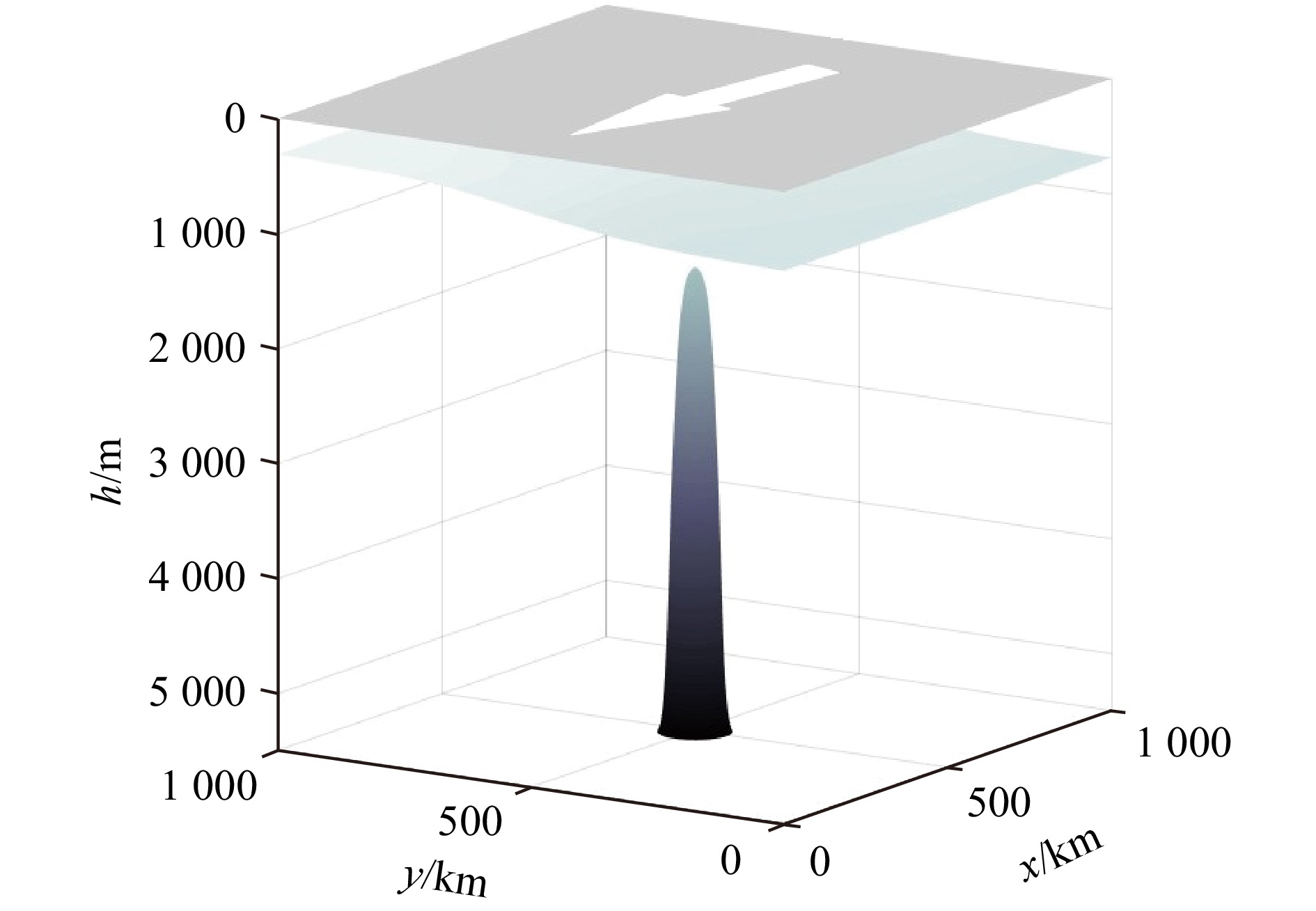
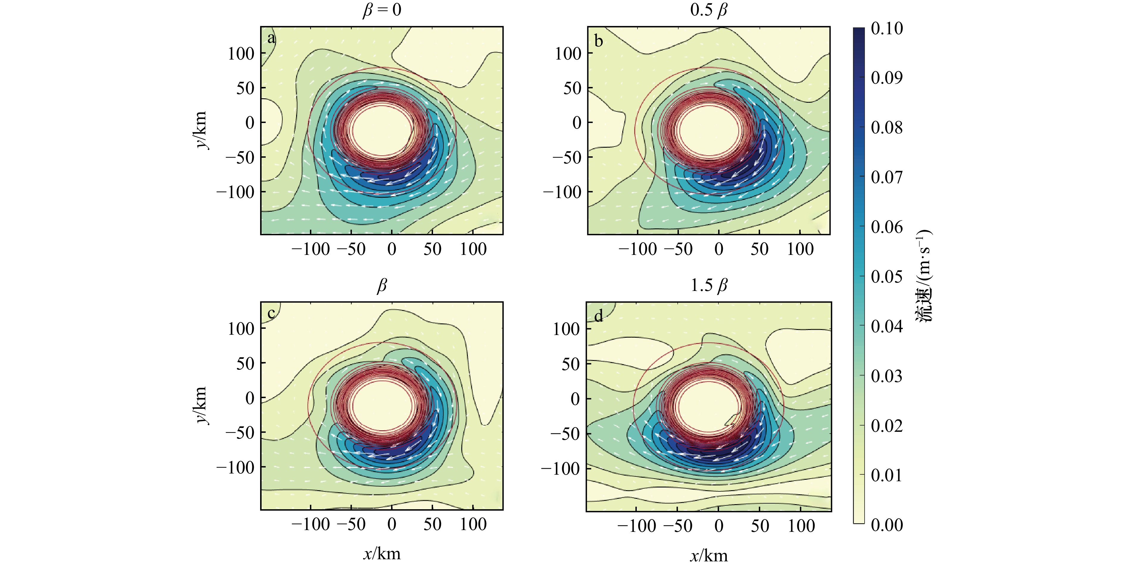
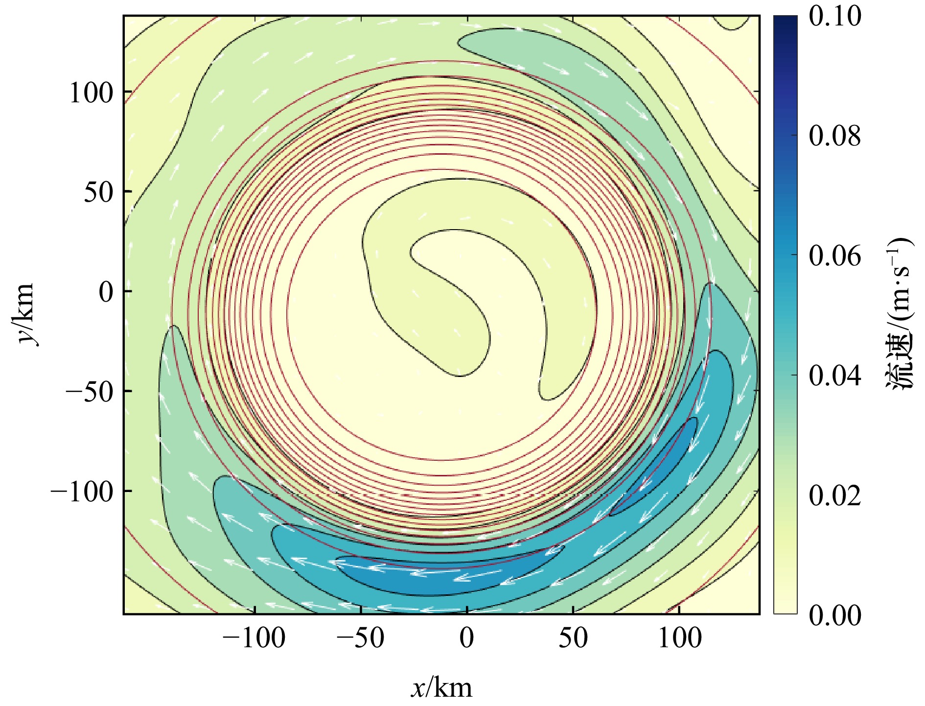
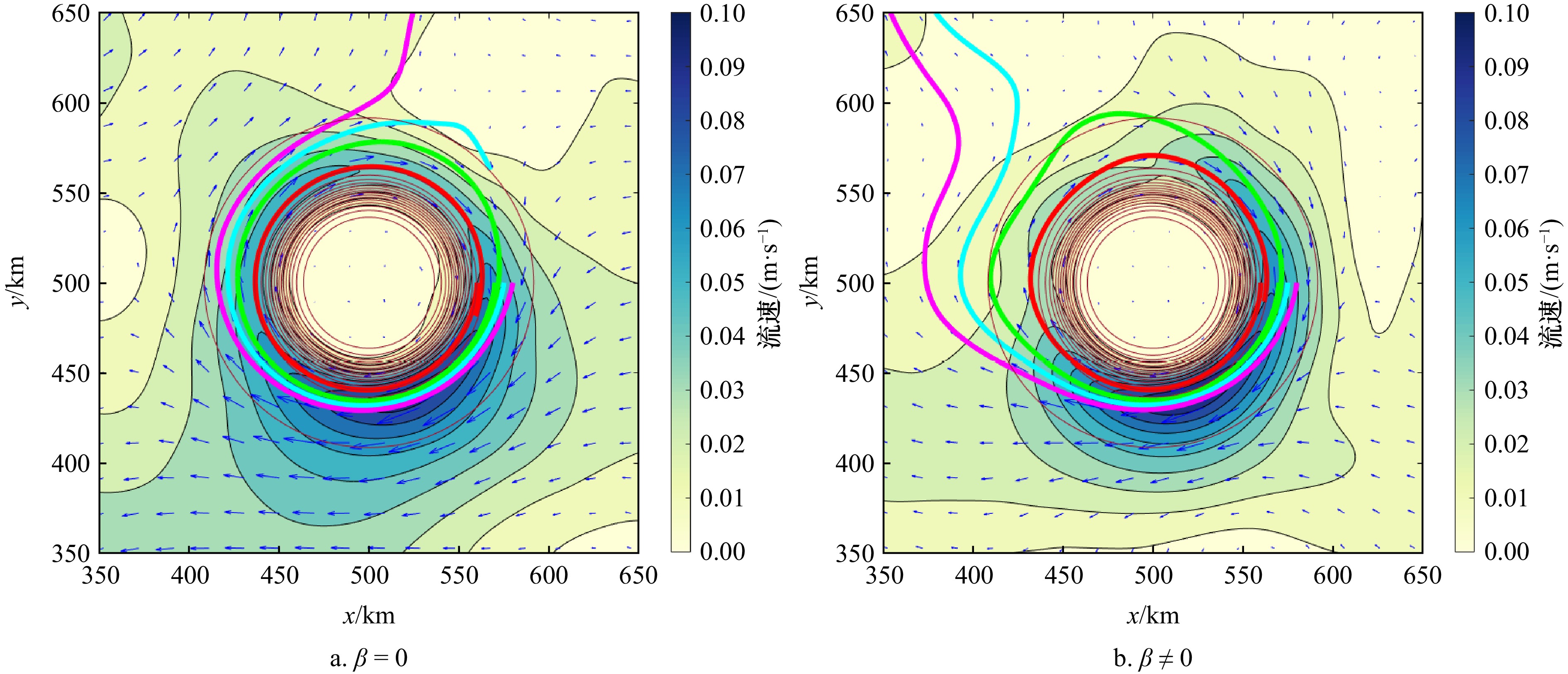
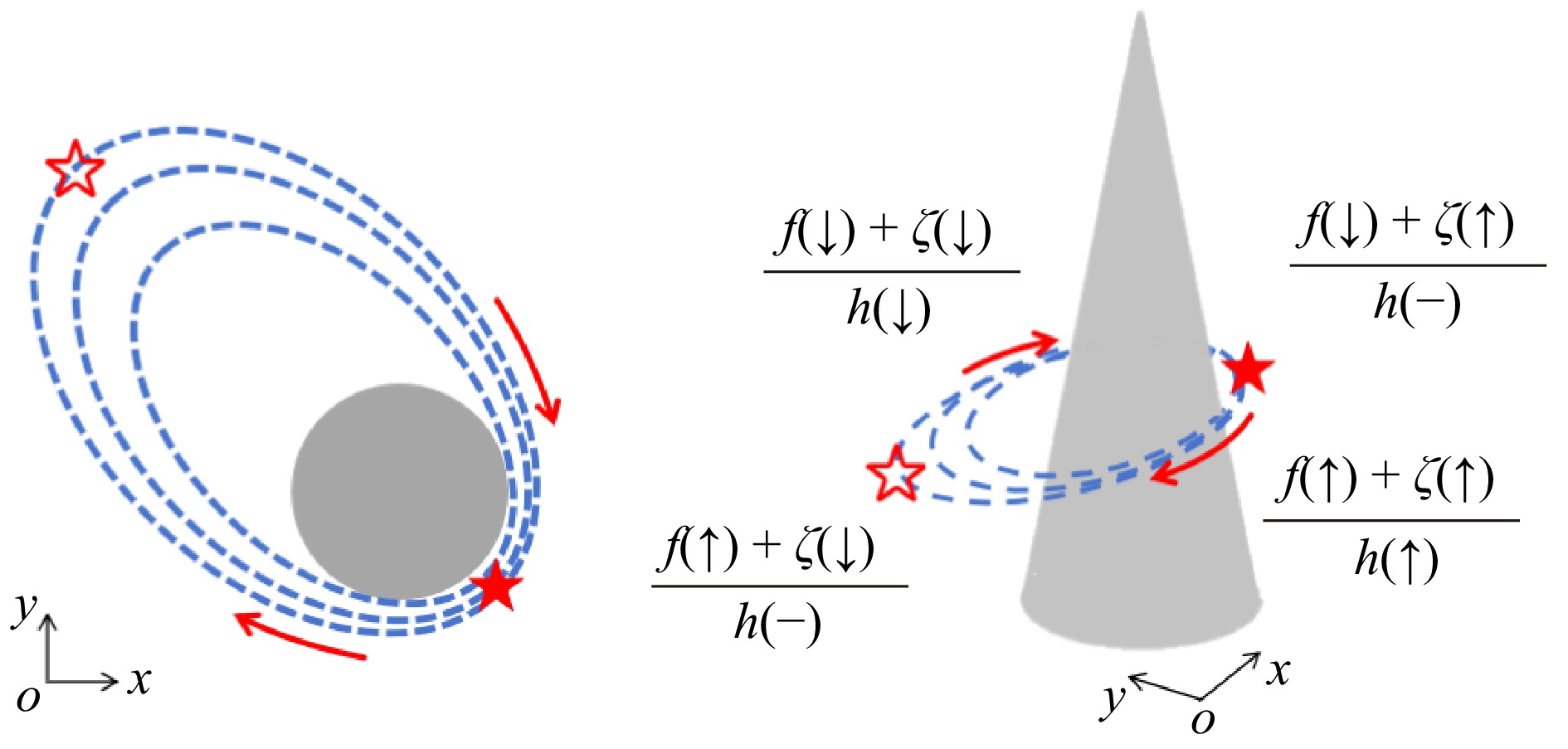
This paper studies the asymmetric characteristics and mechanism of the anticyclonic jet at the bottom of seamounts by using the in situ observations and numerical modeling at the Caiwei Seamount (CS) in the tropical western Pacific. The observation of bottom currents showed that there is a pronounced east-west asymmetry in the anticyclonic jet surrounding the seamount. A two-layer model reproduces the bottom flow field and its asymmetric characteristics of the idealized seamount, suggesting that the primary drivers of this asymmetry are the energy input from the background flow and vorticity change induced by the β effects. The flow field characteristics in all directions around the seamount are sequentially analyzed, and the mechanism by which vorticity changes affect the bottom jet and its asymmetric characteristics is explained in detail. In addition, this paper also discusses the influence of other environmental parameters (such as bottom friction coefficients and reduced gravity) on the bottom anticyclonic jet.
This paper studies the asymmetric characteristics and mechanism of the anticyclonic jet at the bottom of seamounts by using the in situ observations and numerical modeling at the Caiwei Seamount (CS) in the tropical western Pacific. The observation of bottom currents showed that there is a pronounced east-west asymmetry in the anticyclonic jet surrounding the seamount. A two-layer model reproduces the bottom flow field and its asymmetric characteristics of the idealized seamount, suggesting that the primary drivers of this asymmetry are the energy input from the background flow and vorticity change induced by the β effects. The flow field characteristics in all directions around the seamount are sequentially analyzed, and the mechanism by which vorticity changes affect the bottom jet and its asymmetric characteristics is explained in detail. In addition, this paper also discusses the influence of other environmental parameters (such as bottom friction coefficients and reduced gravity) on the bottom anticyclonic jet.


2025, 47(6): 13-21.
doi: 10.12284/hyxb2025051
Abstract:
Satellite altimetry data provides large-scale, long-term stable ocean flow field information, but its low resolution may affect the accuracy of Lagrangian fluid particle trajectories calculated from it. In this study, a comparative approach using buoy trajectories and chlorophyll structure evolution was employed to systematically assess the reliability of Lagrangian fluid particle trajectories derived from altimetry data. The results indicate that this method effectively characterizes mesoscale oceanic motions, with fluid particle trajectories closely matching the overall trends of actual buoy trajectories, particularly demonstrating strong tracking capability in rotational motion patterns. However, the sensitivity of these trajectories to sub-mesoscale motions is relatively low, with slower movement speeds making it difficult to accurately capture short-period perturbations. Further analysis reveals that fluid particle trajectories can reliably track the evolution of chlorophyll structures over a 30-day period, suggesting their applicability in mesoscale oceanic studies. This research provides a scientific basis for the application of altimetry data in Lagrangian analysis and offers valuable insights for the study of ocean circulation and ecological processes.
Satellite altimetry data provides large-scale, long-term stable ocean flow field information, but its low resolution may affect the accuracy of Lagrangian fluid particle trajectories calculated from it. In this study, a comparative approach using buoy trajectories and chlorophyll structure evolution was employed to systematically assess the reliability of Lagrangian fluid particle trajectories derived from altimetry data. The results indicate that this method effectively characterizes mesoscale oceanic motions, with fluid particle trajectories closely matching the overall trends of actual buoy trajectories, particularly demonstrating strong tracking capability in rotational motion patterns. However, the sensitivity of these trajectories to sub-mesoscale motions is relatively low, with slower movement speeds making it difficult to accurately capture short-period perturbations. Further analysis reveals that fluid particle trajectories can reliably track the evolution of chlorophyll structures over a 30-day period, suggesting their applicability in mesoscale oceanic studies. This research provides a scientific basis for the application of altimetry data in Lagrangian analysis and offers valuable insights for the study of ocean circulation and ecological processes.


2025, 47(6): 22-32.
doi: 10.12284/hyxb2025047
Abstract:
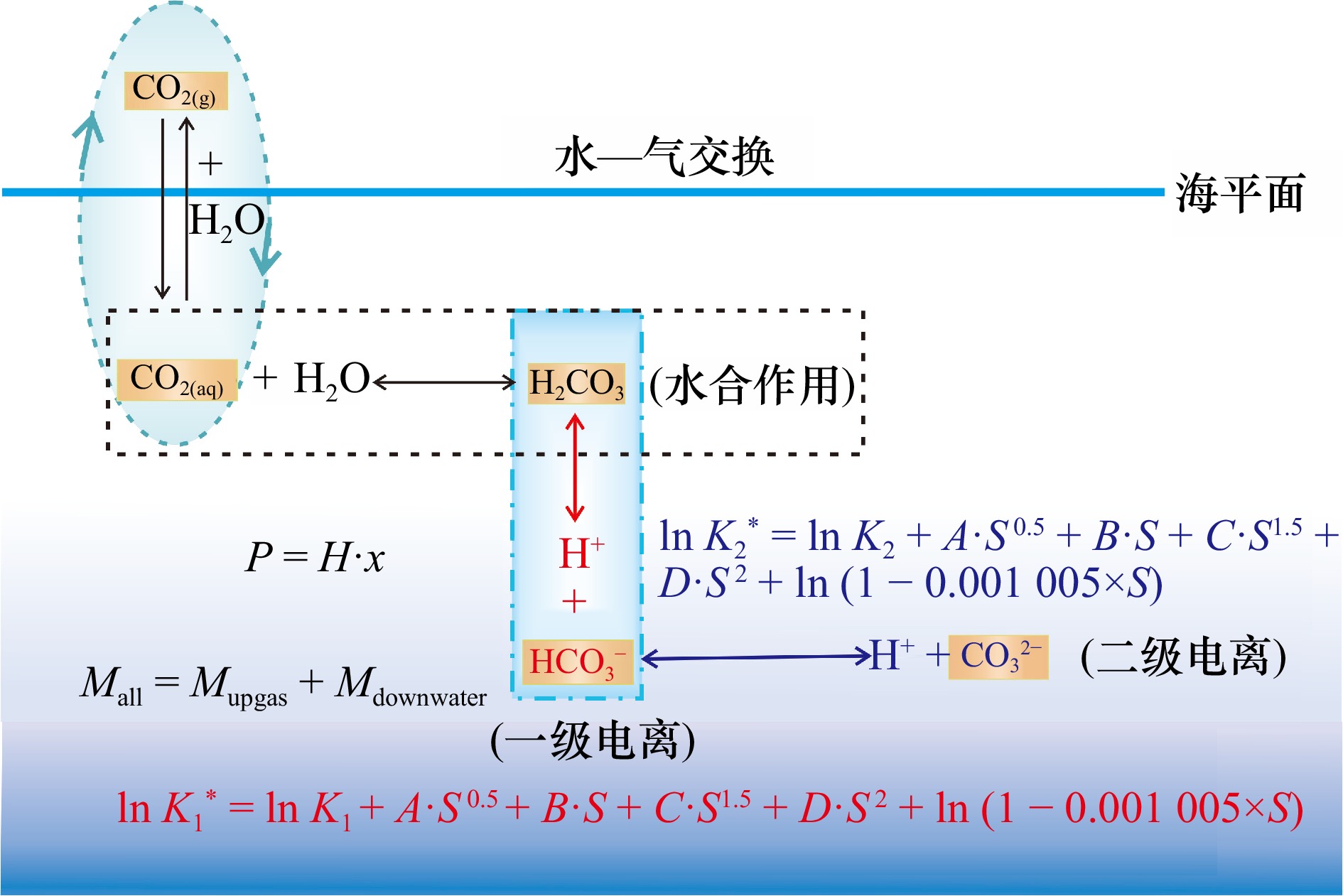
The concentration of dissolved carbon dioxide in seawater affects global climate change, the growth of marine organisms and controls the formation of submarine carbonates, and it is one of the most important indices in the marine environment and mineral resource survey. It has important academic value for the exploration of seabed minerals, monitoring of marine environment, the study of carbon cycle in seabed sediments and even the global carbon cycle. Titration and Henrys are used to determine the concentration of dissolved carbon dioxide in seawater. Titration is suitable for the content of free carbon dioxide in groundwater for a single sample. The Henrys is more suitable for seawater, especially for a great deal of seawater samples collected from the same sea area on board ships, the results are mainly based on the theoretical Henry’s constant of carbon dioxide in seawater. In fact, the Henry’s law constants of carbon dioxide in different seawater are different. In order to achieve higher measurement accuracy and precision, the Henry’s Law Constants of carbon dioxide in seawater have to be determined first. An experimental plan is designed and D-value of Multi Balance Systems is put forward in this article, which is used to determine the Henry’s law constants of carbon dioxide in seawater. D-value of Multi Balance Systems is based on the principle of mass conservation and the dissolution behavior of carbon dioxide in seawater. In D-value of Multi Balance Systems, multiple gas-liquid balance systems with different masses and volumes are constructed in advance, then the Henry’s law constant of carbon dioxide is derived on the basis of the different mass of carbon dioxide between the balance systems. The Henry’s values of carbon dioxide in 24 stratified seawater samples from the South China Sea’s Shenhu Sea are determined by D-value of Multi Balance Systems. At last the scientificalness and feasibility of D-value of Multi Balance Systems are proved by multiple system conversion coincidence experiments.
The concentration of dissolved carbon dioxide in seawater affects global climate change, the growth of marine organisms and controls the formation of submarine carbonates, and it is one of the most important indices in the marine environment and mineral resource survey. It has important academic value for the exploration of seabed minerals, monitoring of marine environment, the study of carbon cycle in seabed sediments and even the global carbon cycle. Titration and Henrys are used to determine the concentration of dissolved carbon dioxide in seawater. Titration is suitable for the content of free carbon dioxide in groundwater for a single sample. The Henrys is more suitable for seawater, especially for a great deal of seawater samples collected from the same sea area on board ships, the results are mainly based on the theoretical Henry’s constant of carbon dioxide in seawater. In fact, the Henry’s law constants of carbon dioxide in different seawater are different. In order to achieve higher measurement accuracy and precision, the Henry’s Law Constants of carbon dioxide in seawater have to be determined first. An experimental plan is designed and D-value of Multi Balance Systems is put forward in this article, which is used to determine the Henry’s law constants of carbon dioxide in seawater. D-value of Multi Balance Systems is based on the principle of mass conservation and the dissolution behavior of carbon dioxide in seawater. In D-value of Multi Balance Systems, multiple gas-liquid balance systems with different masses and volumes are constructed in advance, then the Henry’s law constant of carbon dioxide is derived on the basis of the different mass of carbon dioxide between the balance systems. The Henry’s values of carbon dioxide in 24 stratified seawater samples from the South China Sea’s Shenhu Sea are determined by D-value of Multi Balance Systems. At last the scientificalness and feasibility of D-value of Multi Balance Systems are proved by multiple system conversion coincidence experiments.


2025, 47(6): 33-46.
doi: 10.12284/hyxb2025061
Abstract:
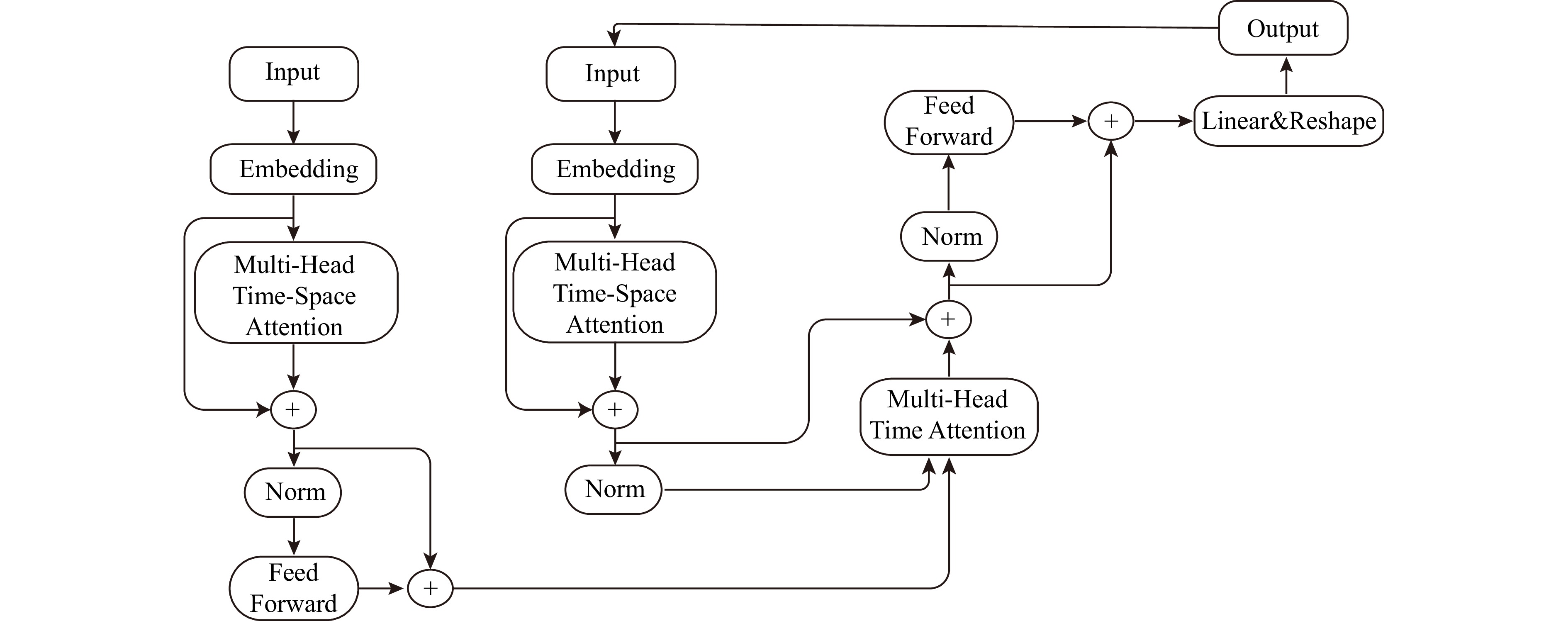
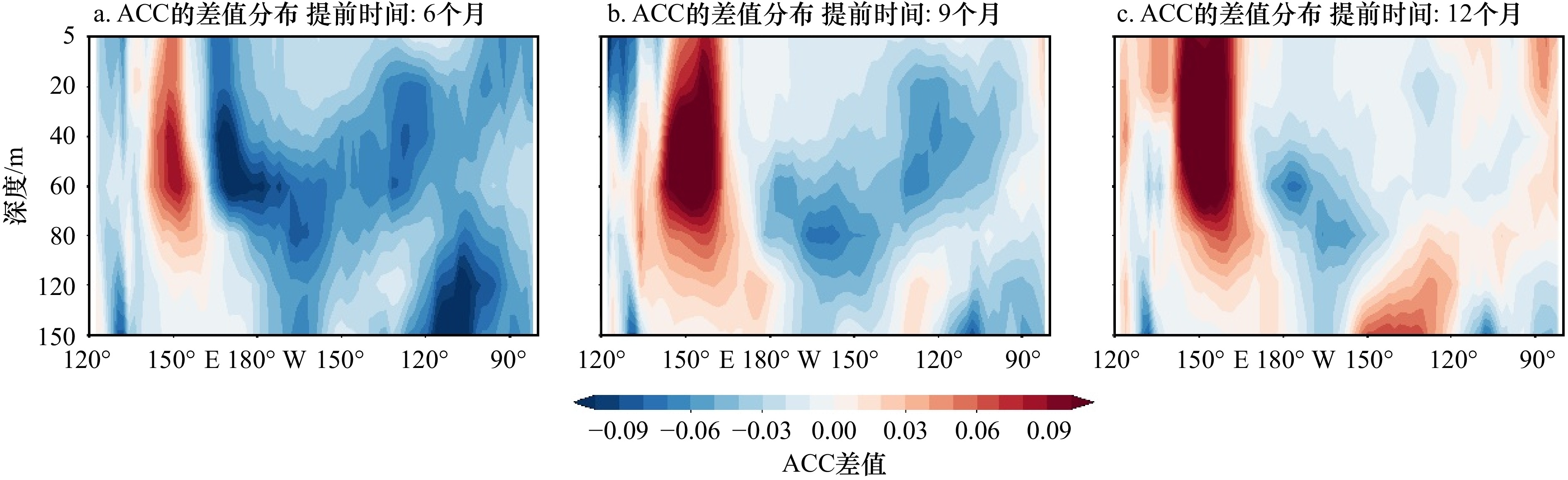
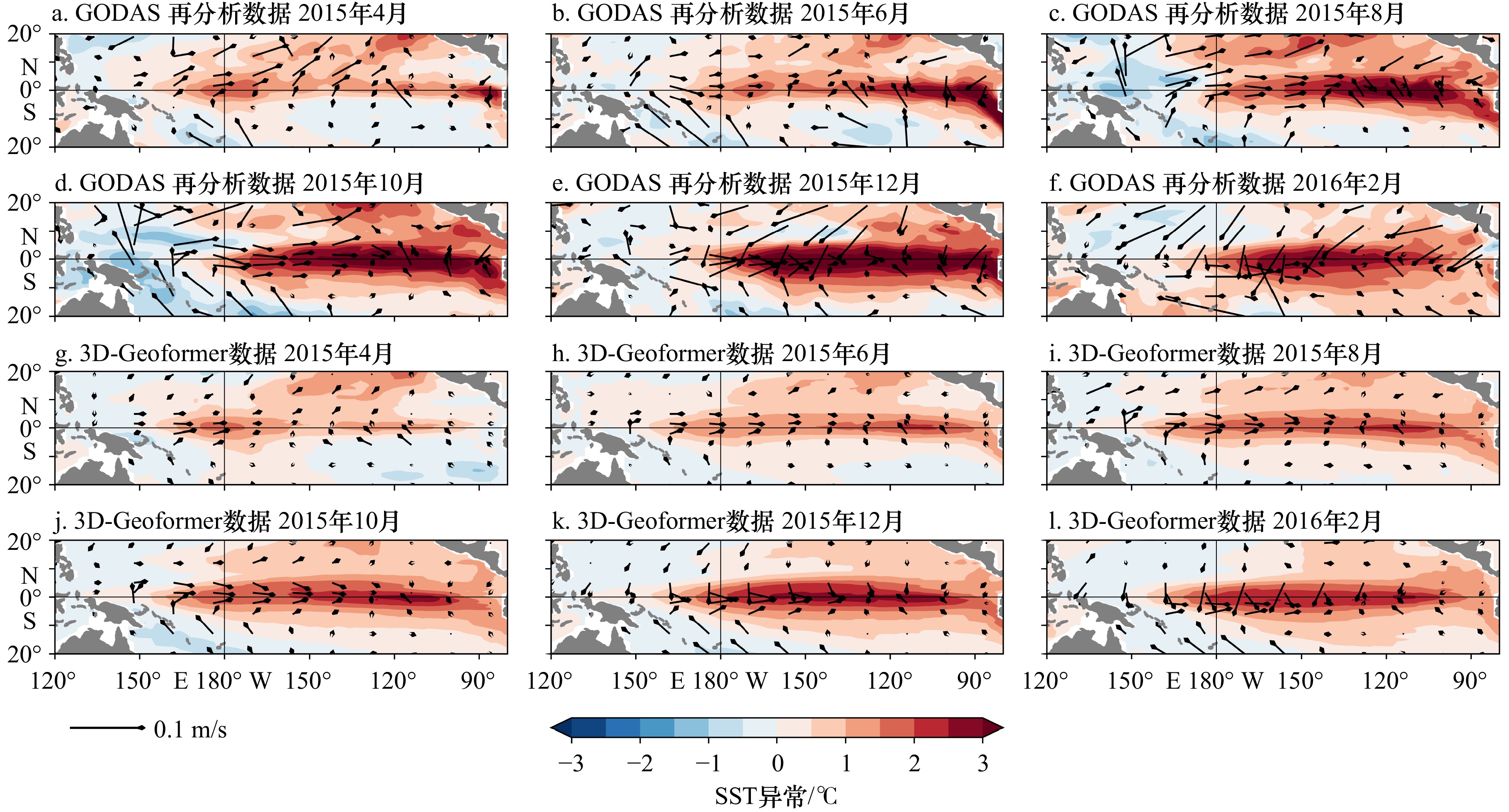
El Niño-Southern Oscillation (ENSO), as the most prominent interannual variability signal in the climate system, exerts significant impacts on global weather and climate. Under global warming, ENSO evolution has increasingly exhibited the characteristics of complex and diverse rendering its simulation and prediction a particularly challenging subject in climatology. This study introduces 3D-Geoformer, an advanced multi-variable intelligent prediction model for the tropical sea-air system based on Transformer architecture, to conduct error analysis and correction research for ENSO predictions. Unlike many existing models that focus solely on univariate fields or time series related to ENSO, the 3D-Geoformer model achieves accurate characterization and prediction of the multi-variable three-dimensional field of the tropical Pacific sea-air system while preserving the integrity of the physical processes essential for ENSO prediction. To address specific issues in ENSO predictions by the 3D-Geoformer model, such as low spring forecasting skills, weak sea surface temperature (SST) forecasting ability in the western equatorial Pacific, and inadequate forecasting intensity for extreme ENSO events, this study proposes a seasonal forecasting error correction technique based on empirical orthogonal function (EOF) decomposition. This method is applied to correct the prediction results of the 3D-Geoformer model. During the construction phase of the correction relationship, EOF analysis was used to establish the linear relationship between the principal component sequences of the multivariable prediction field and the prediction error field from 1983 to 2009. Subsequently, this relationship was utilized for subsequent error corrections. In the testing phase, the EOF principal component coefficients of the prediction field and their linear relationships with the main components of the error were employed to calculate the corresponding principal components of the prediction error, thereby obtaining the prediction error field and the corrected prediction field. The experimental results indicate that when the 3D-Geoformer model is employed for forecasting the sea surface temperature in the western equatorial Pacific, the prediction error remains below 0.15℃. Concurrently, there is a remarkable 46.7% reduction in the prediction error of SST in the central and eastern equatorial Pacific. Through a meticulous comparison of the disparities in the anomaly correlation coefficients (ACC) between the SST prediction outcomes of the 3D-Geoformer model with and without Empirical Orthogonal Function (EOF) correction in the equatorial Pacific, it is discerned that positive-value regions are consistently present in the ACC differences. This finding strongly suggests that the EOF-corrected model exhibits enhanced prediction accuracy, effectively alleviating the “cold tongue bias” issue arising from the utilization of climate model data from the Sixth Coupled Model Inter-comparison Project (CMIP6) during the training phase of the 3D-Geoformer model. For the 2015−2016 El Niño event, forecast corrections made 12 months in advance show that the SST error in the western equatorial Pacific is controlled within 0.5℃, and the SST error in the eastern equatorial Pacific is reduced by approximately 75%, with the error range narrowed to within ±0.5℃. This study underscores the application value of the seasonal forecast error correction method based on EOF decomposition in enhancing model prediction accuracy, providing a novel approach to improving the precision of ENSO intelligent predictions, and offering new insights into simulation prediction and error analysis in earth science.
El Niño-Southern Oscillation (ENSO), as the most prominent interannual variability signal in the climate system, exerts significant impacts on global weather and climate. Under global warming, ENSO evolution has increasingly exhibited the characteristics of complex and diverse rendering its simulation and prediction a particularly challenging subject in climatology. This study introduces 3D-Geoformer, an advanced multi-variable intelligent prediction model for the tropical sea-air system based on Transformer architecture, to conduct error analysis and correction research for ENSO predictions. Unlike many existing models that focus solely on univariate fields or time series related to ENSO, the 3D-Geoformer model achieves accurate characterization and prediction of the multi-variable three-dimensional field of the tropical Pacific sea-air system while preserving the integrity of the physical processes essential for ENSO prediction. To address specific issues in ENSO predictions by the 3D-Geoformer model, such as low spring forecasting skills, weak sea surface temperature (SST) forecasting ability in the western equatorial Pacific, and inadequate forecasting intensity for extreme ENSO events, this study proposes a seasonal forecasting error correction technique based on empirical orthogonal function (EOF) decomposition. This method is applied to correct the prediction results of the 3D-Geoformer model. During the construction phase of the correction relationship, EOF analysis was used to establish the linear relationship between the principal component sequences of the multivariable prediction field and the prediction error field from 1983 to 2009. Subsequently, this relationship was utilized for subsequent error corrections. In the testing phase, the EOF principal component coefficients of the prediction field and their linear relationships with the main components of the error were employed to calculate the corresponding principal components of the prediction error, thereby obtaining the prediction error field and the corrected prediction field. The experimental results indicate that when the 3D-Geoformer model is employed for forecasting the sea surface temperature in the western equatorial Pacific, the prediction error remains below 0.15℃. Concurrently, there is a remarkable 46.7% reduction in the prediction error of SST in the central and eastern equatorial Pacific. Through a meticulous comparison of the disparities in the anomaly correlation coefficients (ACC) between the SST prediction outcomes of the 3D-Geoformer model with and without Empirical Orthogonal Function (EOF) correction in the equatorial Pacific, it is discerned that positive-value regions are consistently present in the ACC differences. This finding strongly suggests that the EOF-corrected model exhibits enhanced prediction accuracy, effectively alleviating the “cold tongue bias” issue arising from the utilization of climate model data from the Sixth Coupled Model Inter-comparison Project (CMIP6) during the training phase of the 3D-Geoformer model. For the 2015−2016 El Niño event, forecast corrections made 12 months in advance show that the SST error in the western equatorial Pacific is controlled within 0.5℃, and the SST error in the eastern equatorial Pacific is reduced by approximately 75%, with the error range narrowed to within ±0.5℃. This study underscores the application value of the seasonal forecast error correction method based on EOF decomposition in enhancing model prediction accuracy, providing a novel approach to improving the precision of ENSO intelligent predictions, and offering new insights into simulation prediction and error analysis in earth science.


2025, 47(6): 47-60.
doi: 10.12284/hyxb2025055
Abstract:
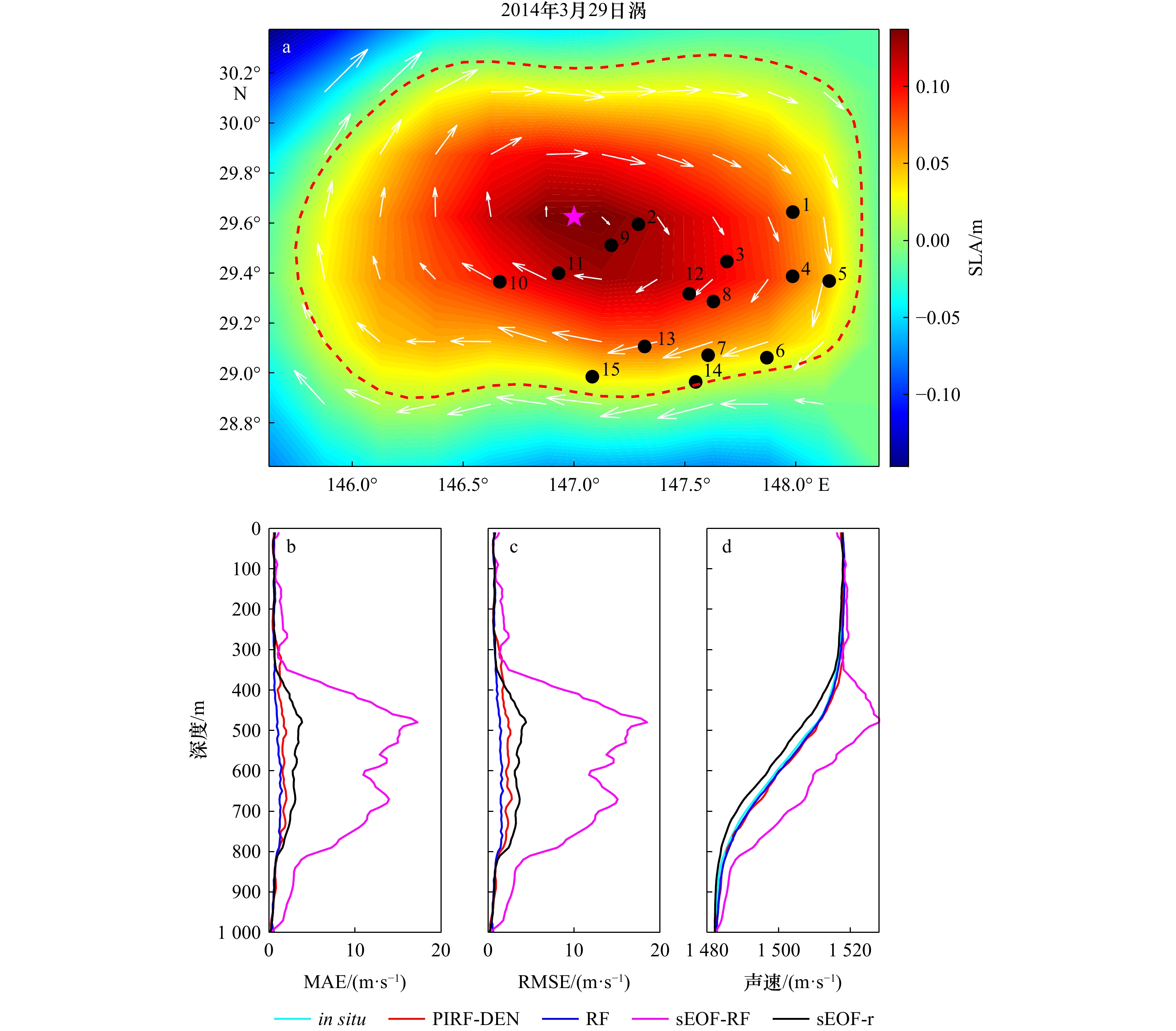
To address the issue of complex sound speed profile (SSP) structures and significantly large reconstruction errors within mesoscale eddies, this study proposes the PIRF-DEN model by integrating multi-source satellite remote sensing data and Argo profiles with a random forest algorithm and a unified mesoscale eddy structure model. By utilizing sea surface temperature, height anomaly, salinity, density, and other environmental parameters at the sea surface, along with Argo density data as inputs, the model establishes a “surface-to-underwater” sound speed mapping relationship. Additionally, it reconstructs the density field within eddies based on the unified mesoscale eddy structure model and incorporates both surface environmental parameters and reconstructed eddy densities into the mapping relationship to reconstruct the SSP within the eddies. The results demonstrate that the PIRF-DEN model markedly enhances the accuracy of SSP reconstruction, reducing the Mean Absolute Error (MAE) and Root Mean Square Error (RMSE) to0.8324 m/s and 1.3869 m/s, respectively. This represents an 87.3% and 83.7% reduction compared to the traditional sEOF-r method. Furthermore, the sound speed reconstruction accuracy and stability of the PIRF-DEN model surpass those of existing models.
To address the issue of complex sound speed profile (SSP) structures and significantly large reconstruction errors within mesoscale eddies, this study proposes the PIRF-DEN model by integrating multi-source satellite remote sensing data and Argo profiles with a random forest algorithm and a unified mesoscale eddy structure model. By utilizing sea surface temperature, height anomaly, salinity, density, and other environmental parameters at the sea surface, along with Argo density data as inputs, the model establishes a “surface-to-underwater” sound speed mapping relationship. Additionally, it reconstructs the density field within eddies based on the unified mesoscale eddy structure model and incorporates both surface environmental parameters and reconstructed eddy densities into the mapping relationship to reconstruct the SSP within the eddies. The results demonstrate that the PIRF-DEN model markedly enhances the accuracy of SSP reconstruction, reducing the Mean Absolute Error (MAE) and Root Mean Square Error (RMSE) to


2025, 47(6): 61-72.
doi: 10.12284/hyxb2025057
Abstract:
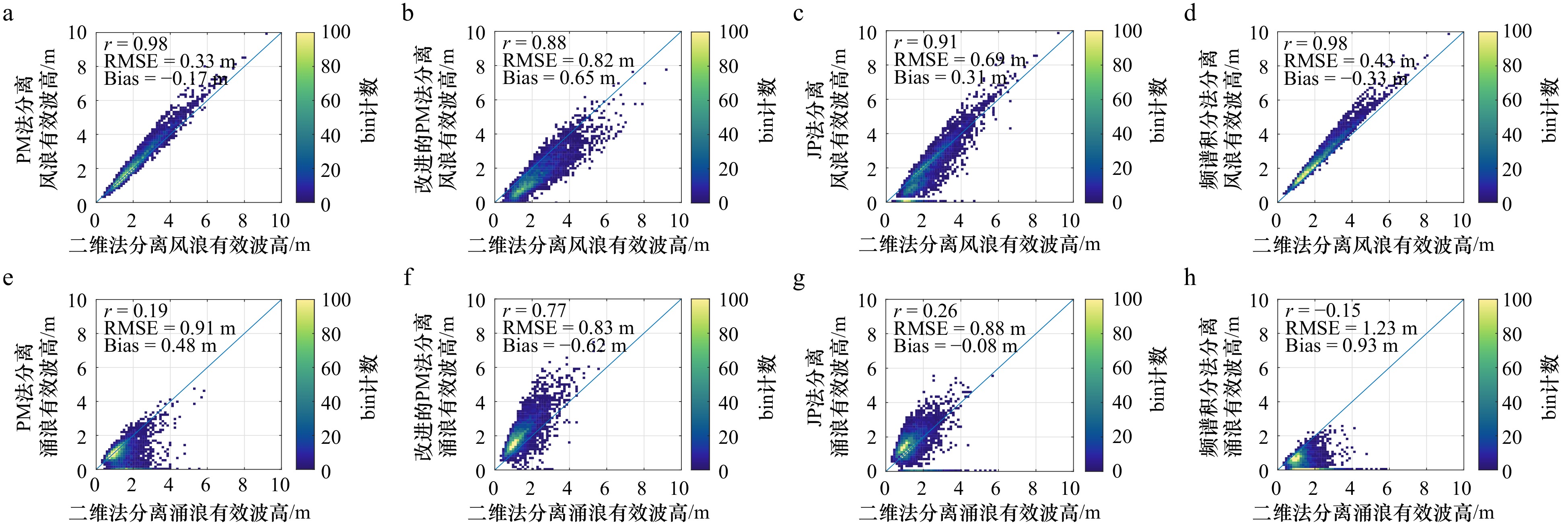
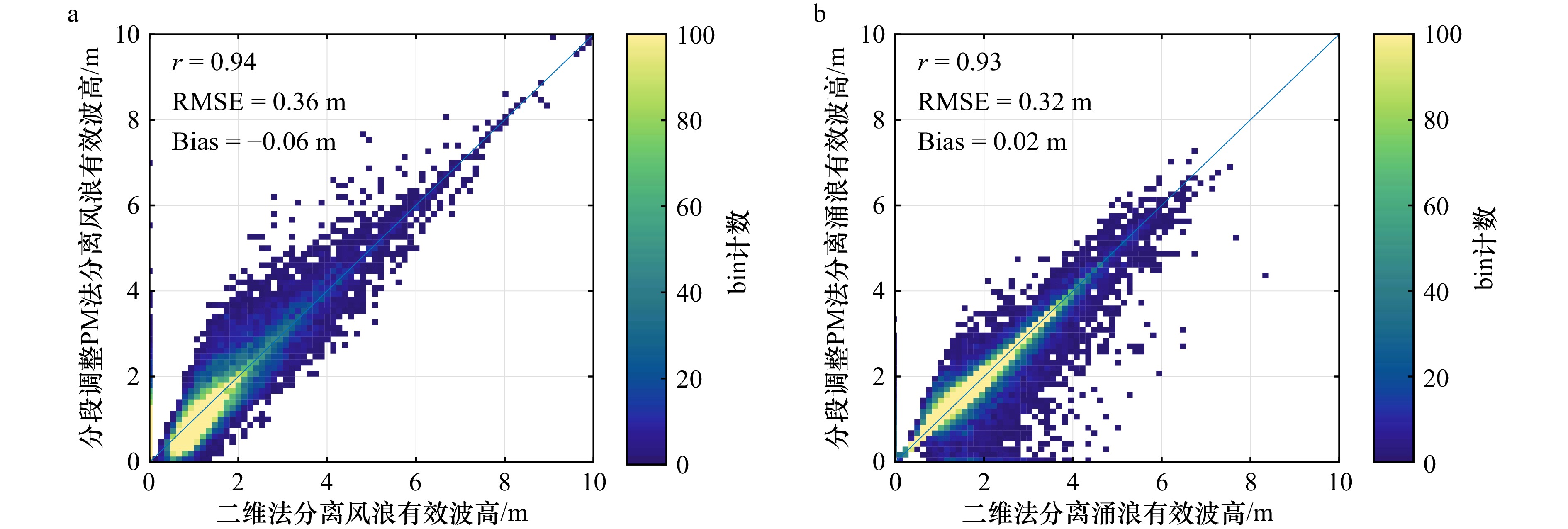
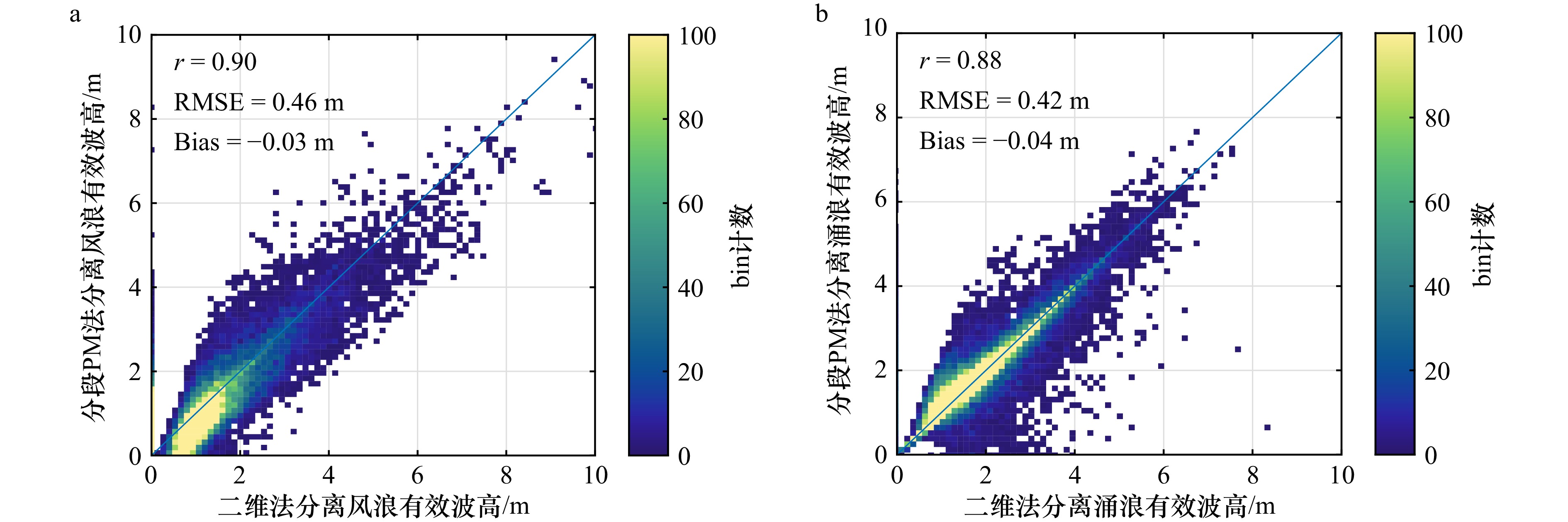
Mixed waves in the ocean typically consist of wind-sea and swell in varying proportions. Separation of wind-sea and swell components is frequently required for research or operational purposes. This paper focuses on four existing representative one-dimensional spectral wind-sea and swell separation methods (1D methods): the PM method (Pierson-Moskowitz), the improved PM method, the JP method (Jesús-Portilla), and the spectral integral method. Using two-dimensional wave spectrum data provided by the spectrometer onboard the China-France Oceanography Satellite, a comparative analysis of the separation results under four wave-dominant conditions—pure wind-sea, wind-sea-dominant, swell-dominant, and pure swell—was conducted. The results show that: (1) The PM method and the improved PM method perform better under wind-sea-dominant and swell-dominant conditions, respectively. (2) The JP method performs poorly overall and is insensitive to different wave-dominant conditions; the spectral integral method performs better when wind-sea dominate. (3) As the proportion of swell in mixed waves increases, appropriately increasing the frequency ratio coefficient in the PM method can improve separation accuracy. Based on this, a piecewise PM method considering wave age is proposed. By adjusting the proportional coefficient of the separation frequency to 1.03 for wind-sea-dominated conditions and 1.1 for swell-dominated conditions, the separation results obtained are more accurate.
Mixed waves in the ocean typically consist of wind-sea and swell in varying proportions. Separation of wind-sea and swell components is frequently required for research or operational purposes. This paper focuses on four existing representative one-dimensional spectral wind-sea and swell separation methods (1D methods): the PM method (Pierson-Moskowitz), the improved PM method, the JP method (Jesús-Portilla), and the spectral integral method. Using two-dimensional wave spectrum data provided by the spectrometer onboard the China-France Oceanography Satellite, a comparative analysis of the separation results under four wave-dominant conditions—pure wind-sea, wind-sea-dominant, swell-dominant, and pure swell—was conducted. The results show that: (1) The PM method and the improved PM method perform better under wind-sea-dominant and swell-dominant conditions, respectively. (2) The JP method performs poorly overall and is insensitive to different wave-dominant conditions; the spectral integral method performs better when wind-sea dominate. (3) As the proportion of swell in mixed waves increases, appropriately increasing the frequency ratio coefficient in the PM method can improve separation accuracy. Based on this, a piecewise PM method considering wave age is proposed. By adjusting the proportional coefficient of the separation frequency to 1.03 for wind-sea-dominated conditions and 1.1 for swell-dominated conditions, the separation results obtained are more accurate.


2025, 47(6): 73-90.
doi: 10.12284/hyxb2025059
Abstract:
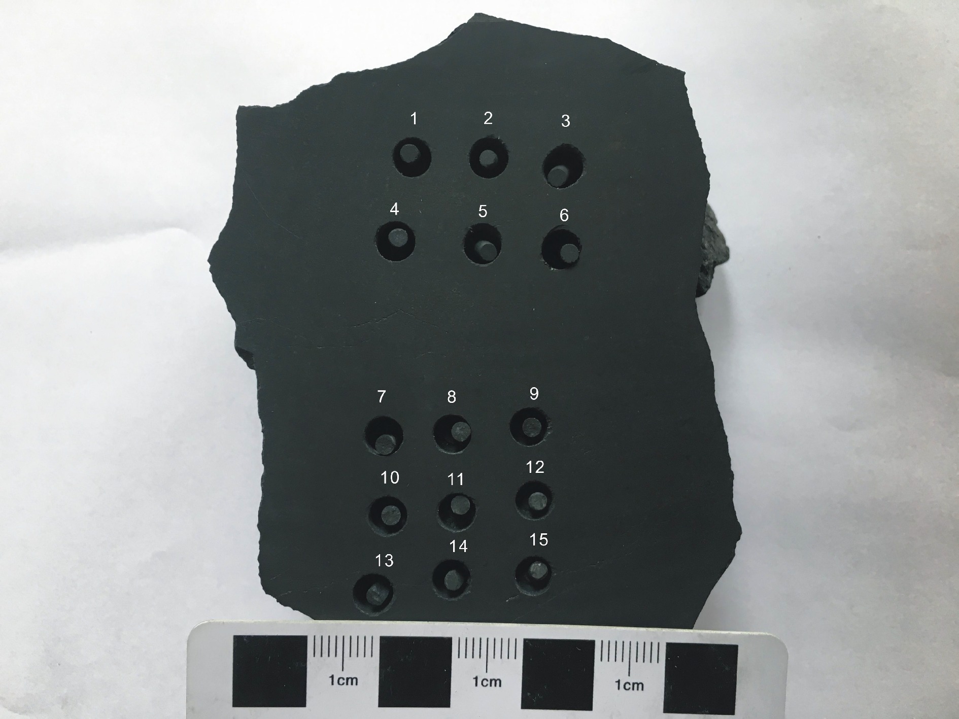
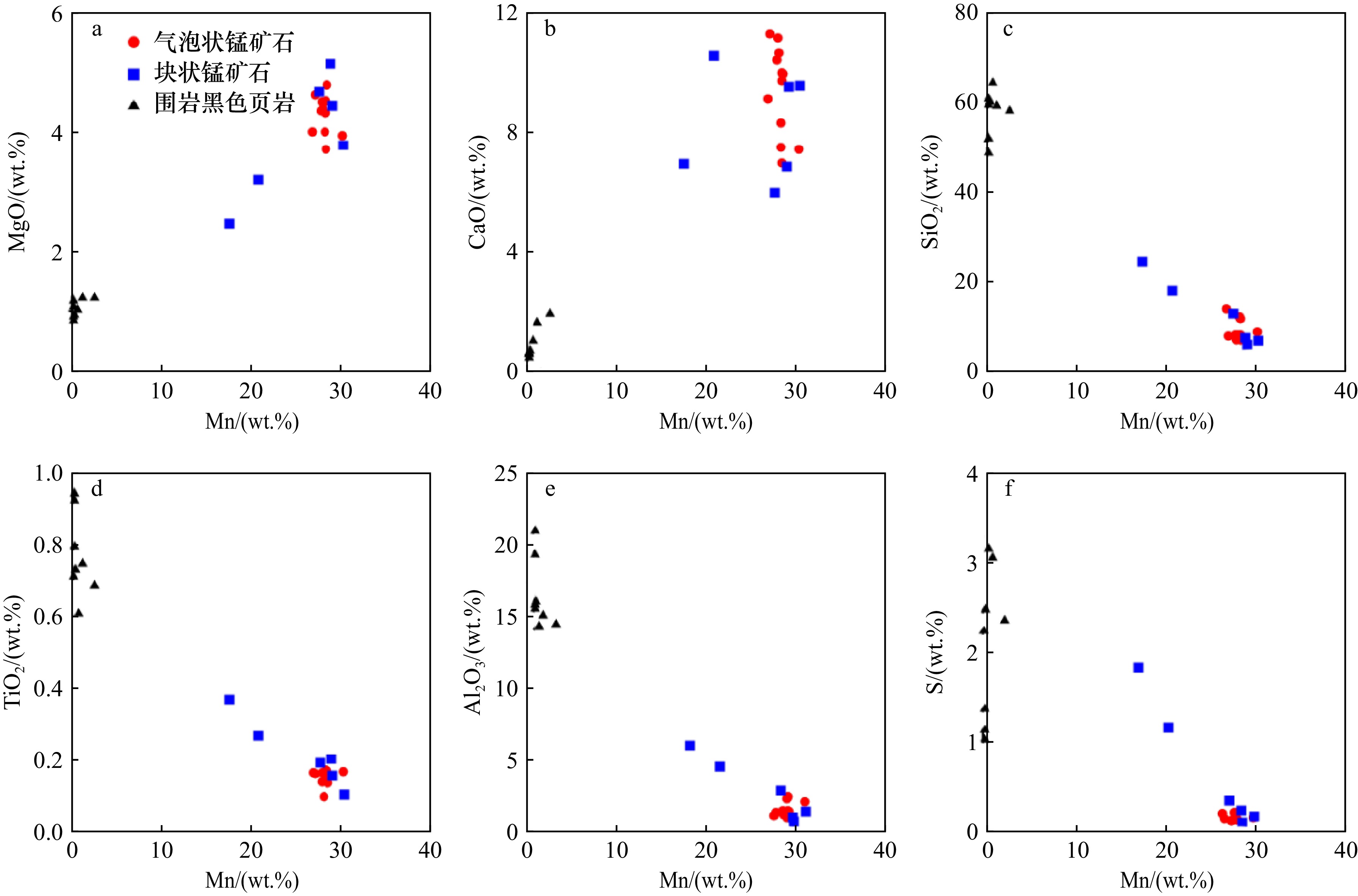
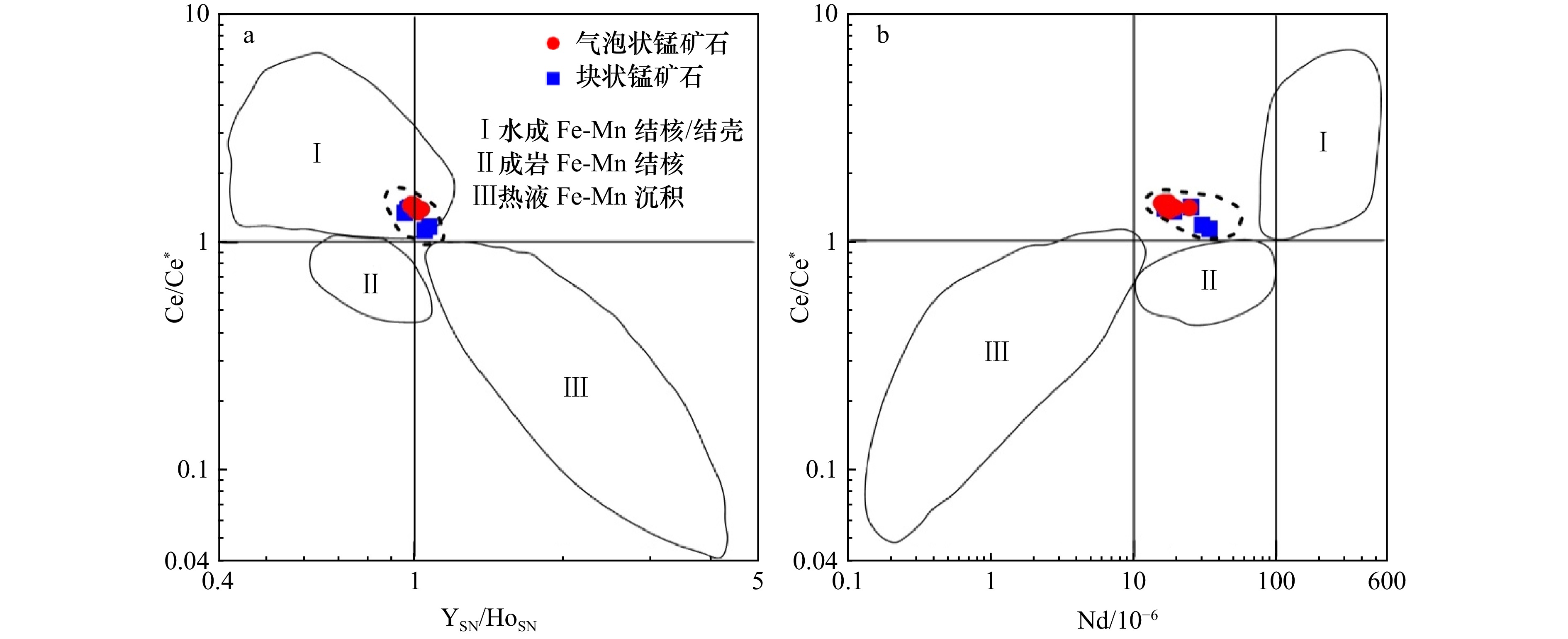
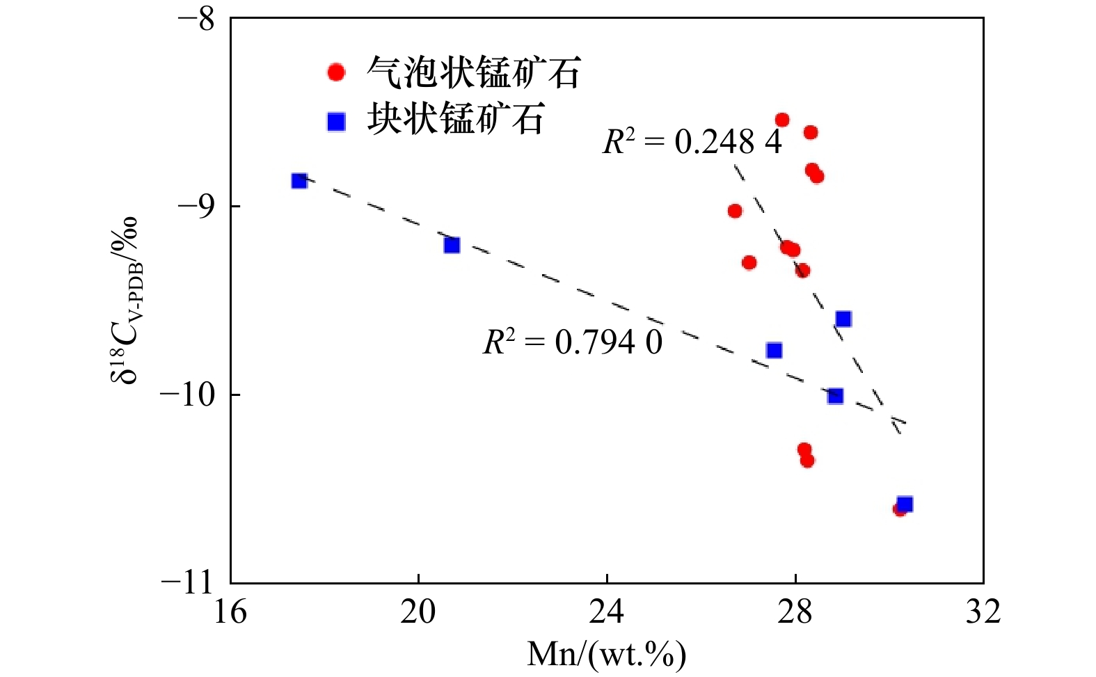
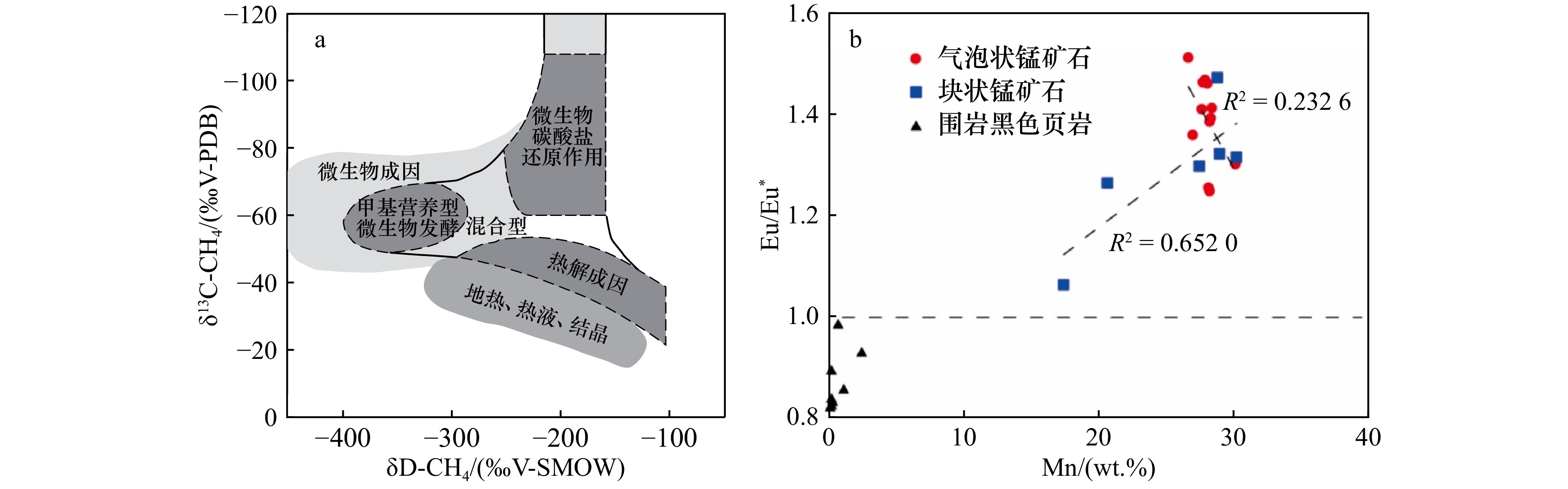
The Zhaiying carbonate-type Mn deposit belongs to the black shale hosted marine manganese(Mn)-bearing formations within the Datangpo Formation in the Nanhua Rift Basin in South China. Unlike other Mn deposits of the Datangpo Formation, parts of the Mn ores in the Zhaiying deposit bear unique bubble structures. To elucidate the metallogenic mechanism of the Zhaiying marine Mn-bearing formation, in this study, petrographic and whole-rock geochemical analyses, including measurements of major and trace elements, organic carbon isotopes, and carbonate carbon stable isotopes, were conducted using the bubble and massive Mn ores as well as host rocks (black shales). The main results are as follows: (1) The PAAS-normalized rare-earth element pattern of the Zhaiying Mn ores exhibits a “hat-shaped” plot. The Mn ores exhibit obvious positive Ce anomalies and are depleted in U and V, implying that the primary depositional environment of the Mn ores was oxidative. Primary Mn oxidizing precipitation has a mechanism similar to marine hydrogenous Mn-Fe nodules and crusts. However, the obvious absence of Ce anomalies and enrichment of pyrites in the host rocks indicate an anoxic depositional environment. (2) The Mn ores are enriched in light δ13Ccarb (−10.60‰ to −8.53‰, averaging at −9.45‰), similar to those belonging to major carbonate-type Mn deposits during geological time. This indicates that primary Mn oxides, as electron acceptors, oxidized organic matter to provide\begin{document}${\mathrm{HCO}}_{3}^- $\end{document} ![]()
![]()
The Zhaiying carbonate-type Mn deposit belongs to the black shale hosted marine manganese(Mn)-bearing formations within the Datangpo Formation in the Nanhua Rift Basin in South China. Unlike other Mn deposits of the Datangpo Formation, parts of the Mn ores in the Zhaiying deposit bear unique bubble structures. To elucidate the metallogenic mechanism of the Zhaiying marine Mn-bearing formation, in this study, petrographic and whole-rock geochemical analyses, including measurements of major and trace elements, organic carbon isotopes, and carbonate carbon stable isotopes, were conducted using the bubble and massive Mn ores as well as host rocks (black shales). The main results are as follows: (1) The PAAS-normalized rare-earth element pattern of the Zhaiying Mn ores exhibits a “hat-shaped” plot. The Mn ores exhibit obvious positive Ce anomalies and are depleted in U and V, implying that the primary depositional environment of the Mn ores was oxidative. Primary Mn oxidizing precipitation has a mechanism similar to marine hydrogenous Mn-Fe nodules and crusts. However, the obvious absence of Ce anomalies and enrichment of pyrites in the host rocks indicate an anoxic depositional environment. (2) The Mn ores are enriched in light δ13Ccarb (−10.60‰ to −8.53‰, averaging at −9.45‰), similar to those belonging to major carbonate-type Mn deposits during geological time. This indicates that primary Mn oxides, as electron acceptors, oxidized organic matter to provide


2025, 47(6): 91-101.
doi: 10.12284/hyxb2025049
Abstract:
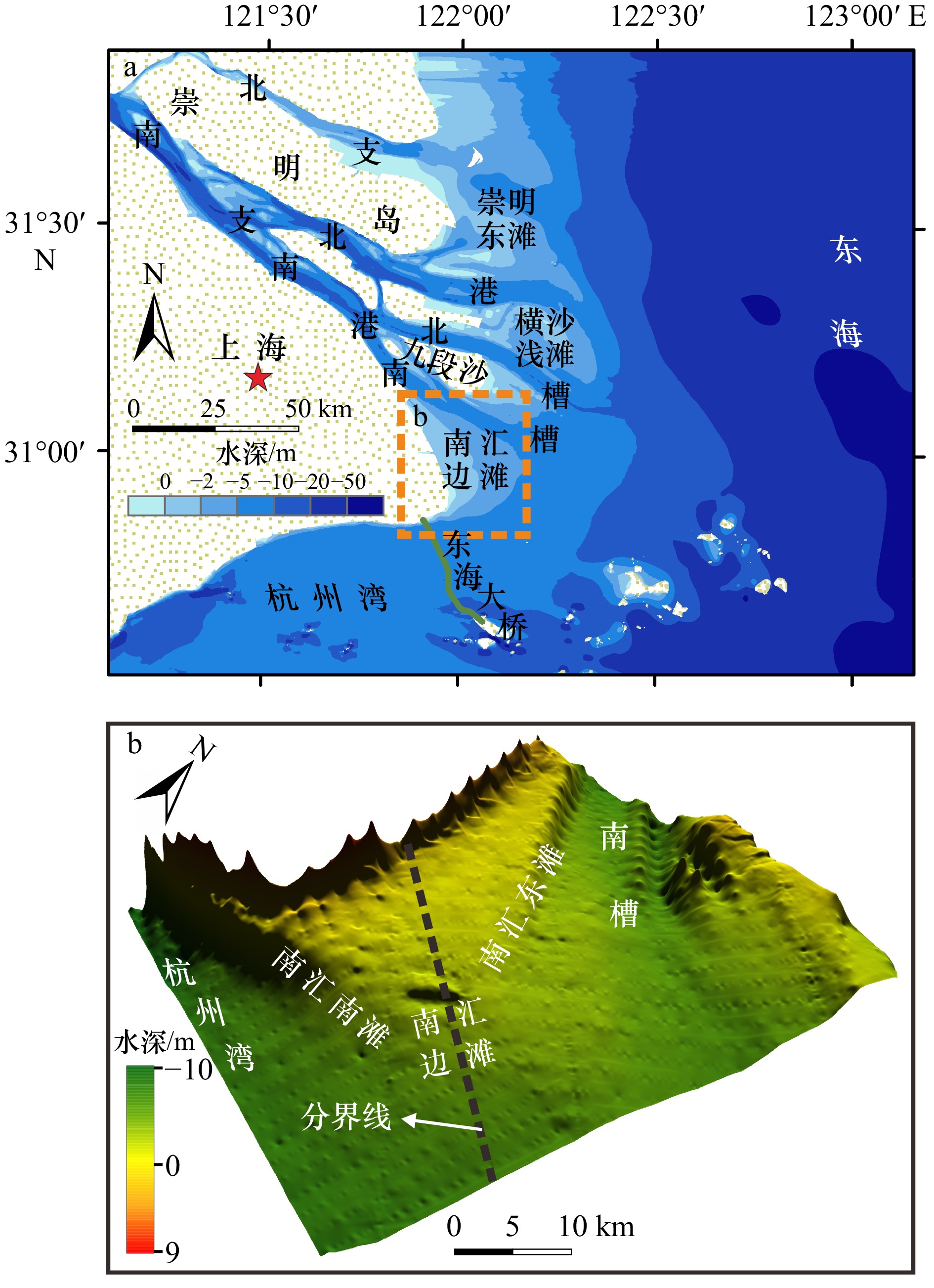
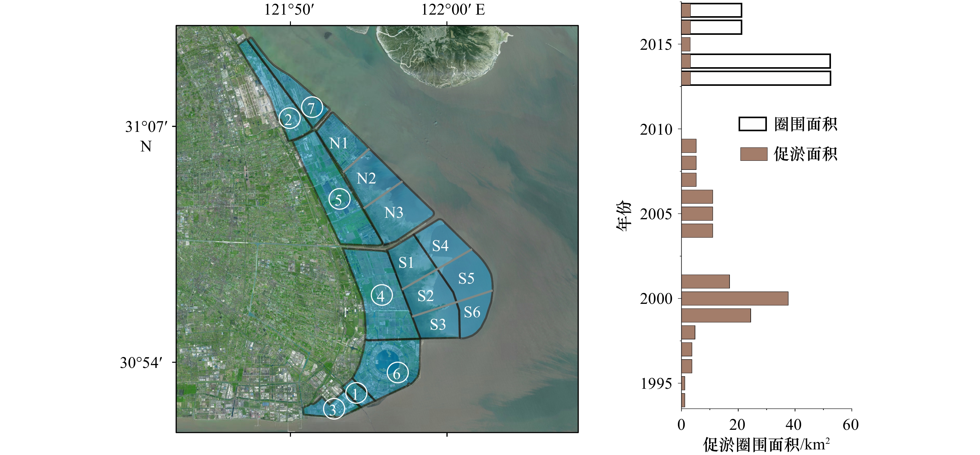
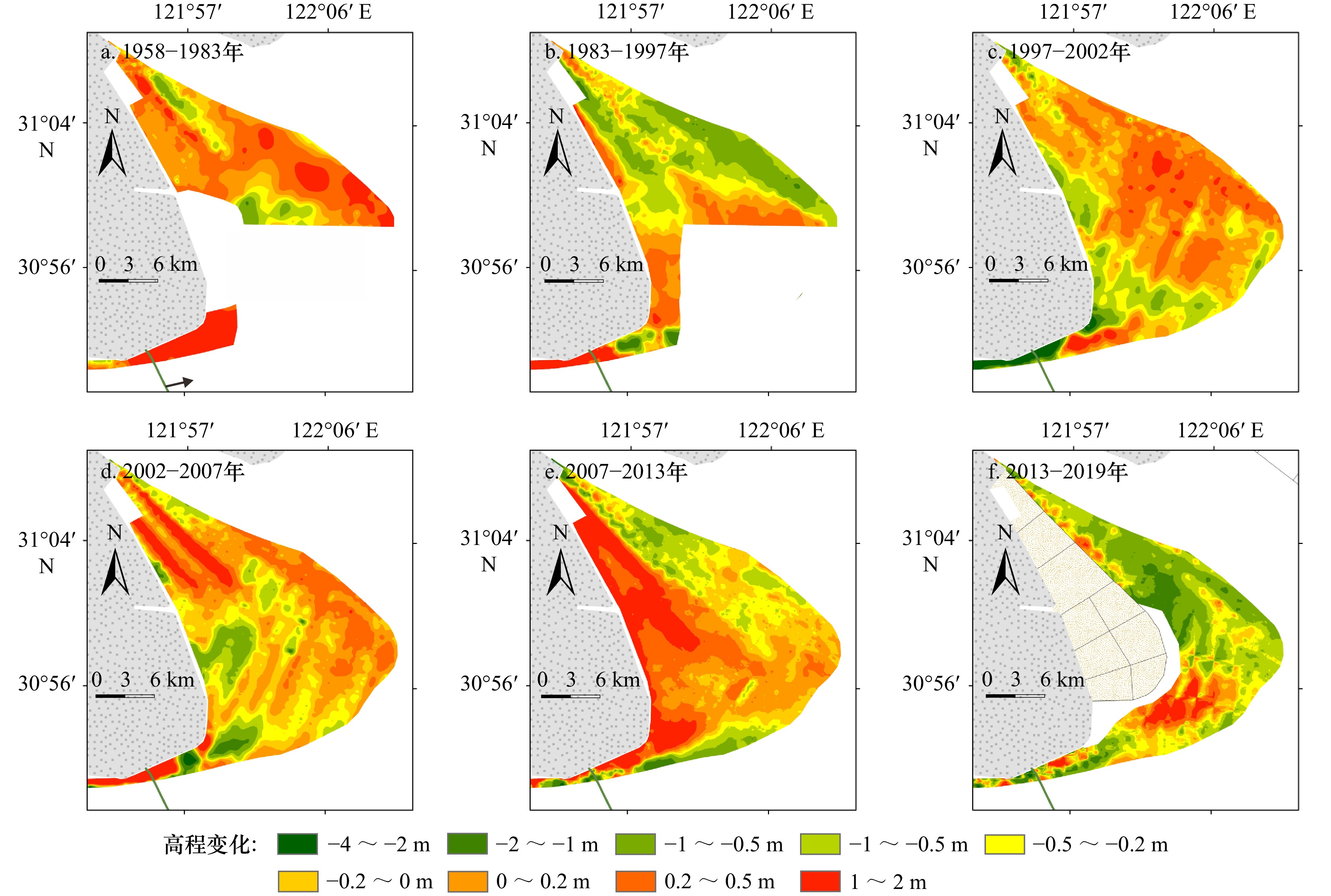
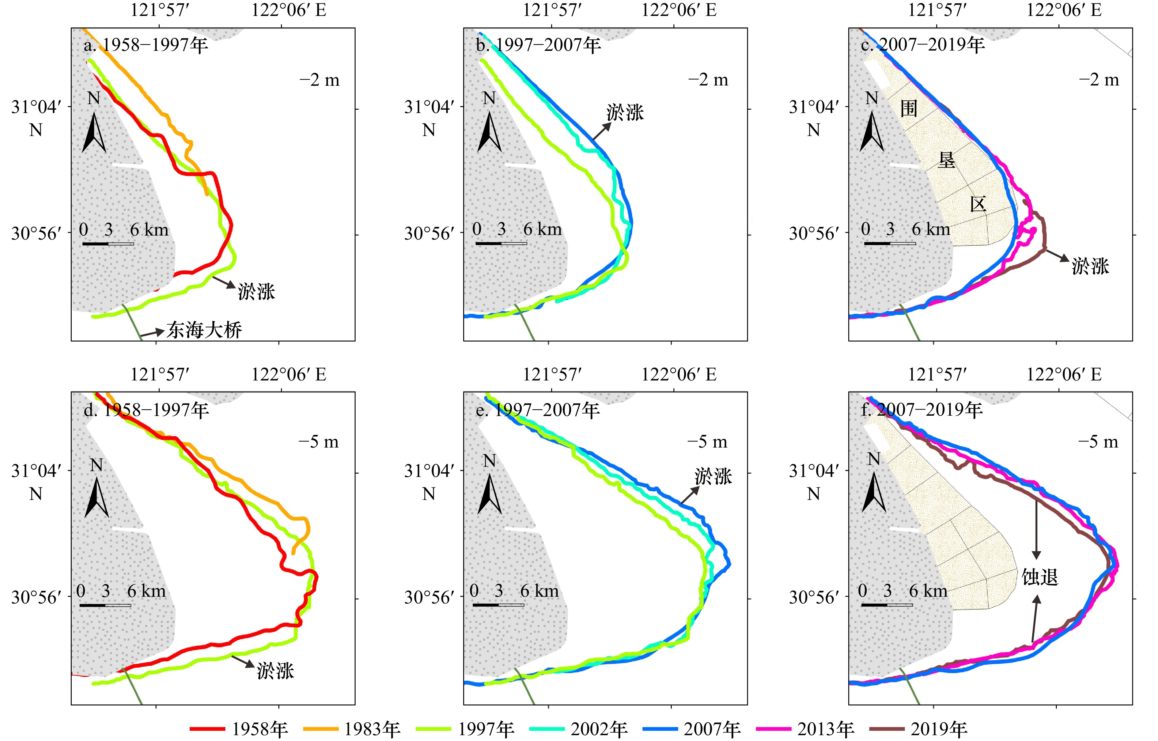
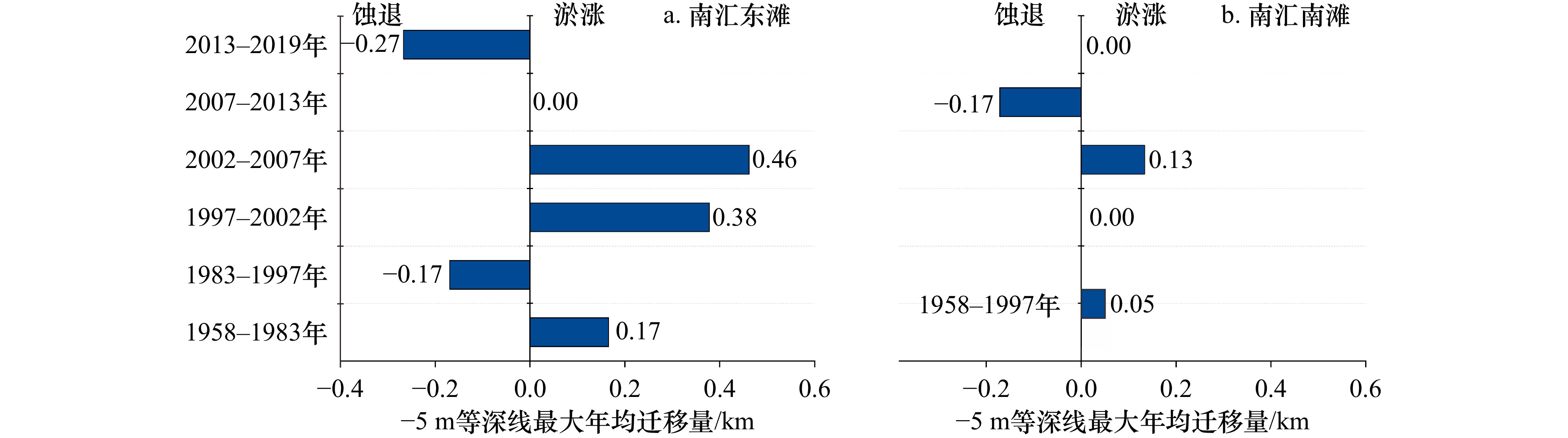
For the past two thousand years, the southern bank of the Changjiang River Estuary has basically shown an evolutionary trend of “shoal extension”, with a rate of about 1 km of siltation and development towards the sea every 40 years. It is the most important land growth area and tidal wetland resource in Shanghai, and the research significance is significant. This paper studies the evolution characteristics of Nanhui Shoal in the past 60 years based on indicators such as scouring and silting characteristics, isobath changes and mudflat migration rate from 1958 to 2019, and discusses its growth mode, driving factors and development trend through space-time comparison. The results showed that: (1) From 1958 to 2019, the Nanhuibian Shoal exhibited four stages of gradual siltation, rapid siltation, near siltation and far erosion, and comprehensive erosion. During this stage, the fastest siltation and erosion rates were 460 m/a and 270 m/a, respectively. (2) Human activities have become the main controlling factors affecting the evolution of the Nanhui Shoal at the mouth of the Changjiang River. Among them, variable factors such as watershed dam construction, Changjiang River Estuary bifurcation control engineering, Shoal reclamation and land reclamation, and channel dredging and sand mining have greatly affected the evolution of the Nanhui Shoal. The correlation between Shoal reclamation and terrain evolution is strong, with a correlation coefficient of 0.73. (3) With the strict control of land reclamation by the government and Shanghai, the Nanhui Beach will gradually reach a new balance of erosion and deposition in the future. It is recommended to study the protection and management measures of estuarine tidal wetlands as soon as possible to cope with possible coastal disasters in the future.
For the past two thousand years, the southern bank of the Changjiang River Estuary has basically shown an evolutionary trend of “shoal extension”, with a rate of about 1 km of siltation and development towards the sea every 40 years. It is the most important land growth area and tidal wetland resource in Shanghai, and the research significance is significant. This paper studies the evolution characteristics of Nanhui Shoal in the past 60 years based on indicators such as scouring and silting characteristics, isobath changes and mudflat migration rate from 1958 to 2019, and discusses its growth mode, driving factors and development trend through space-time comparison. The results showed that: (1) From 1958 to 2019, the Nanhuibian Shoal exhibited four stages of gradual siltation, rapid siltation, near siltation and far erosion, and comprehensive erosion. During this stage, the fastest siltation and erosion rates were 460 m/a and 270 m/a, respectively. (2) Human activities have become the main controlling factors affecting the evolution of the Nanhui Shoal at the mouth of the Changjiang River. Among them, variable factors such as watershed dam construction, Changjiang River Estuary bifurcation control engineering, Shoal reclamation and land reclamation, and channel dredging and sand mining have greatly affected the evolution of the Nanhui Shoal. The correlation between Shoal reclamation and terrain evolution is strong, with a correlation coefficient of 0.73. (3) With the strict control of land reclamation by the government and Shanghai, the Nanhui Beach will gradually reach a new balance of erosion and deposition in the future. It is recommended to study the protection and management measures of estuarine tidal wetlands as soon as possible to cope with possible coastal disasters in the future.

2025, 47(6): 102-118.
doi: 10.12284/hyxb2025043
Abstract:
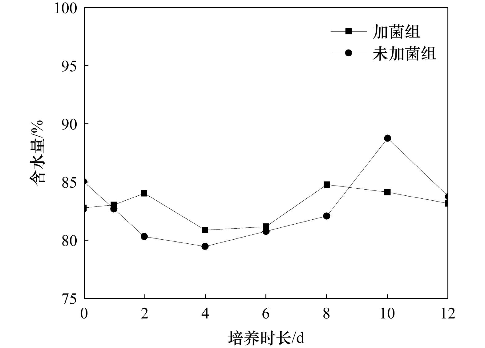
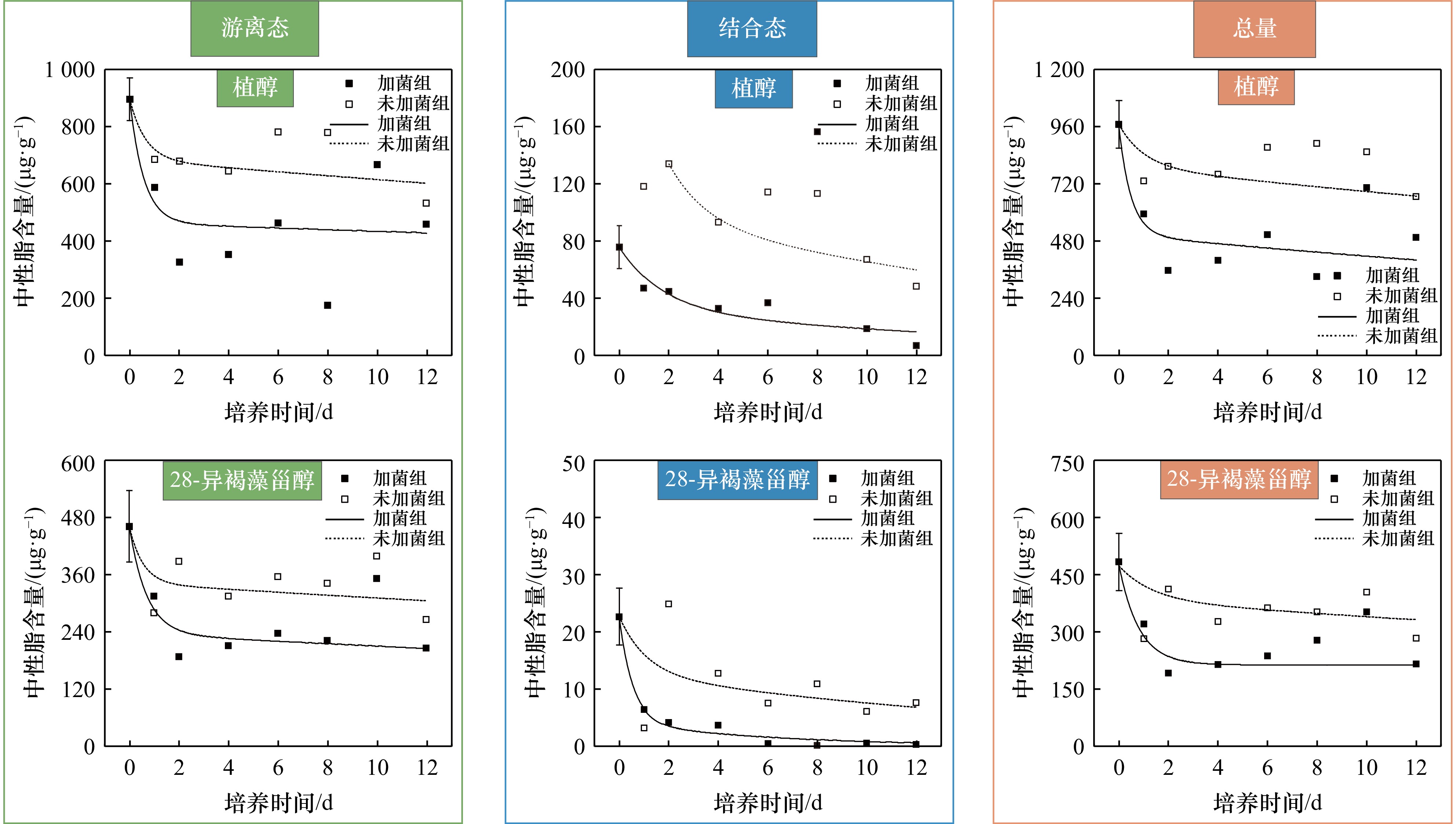
A series of seawater culture experiments were conducted to simulate the degradation of Ulva prolfiera in coastal area under the influence of exogenous degradation microbial consortia. The degradation mechanism of U. prolifera in seawater under the influence of the exogenous degradation microbial consortia was investigated by tracking the time-dependent changes of lipid biomarkers in culture system. The results showed that for most of the fatty acids (14∶0, i-15∶0 + a-15∶0, 16∶0, 16∶1ω7, 17∶0, 18∶0, 18∶1ω7, 18∶1ω9, 18∶3, 18∶4, 20∶0, 22∶0) and neutral lipids of U. prolifera in different forms, their contents presented trends of firstly rapid decline and followed by a slow decline or maintain stability in the culture system with and without exogenous microbial consortia. Under the influence of exogenous microbial consortia, the degradation efficiency of fatty acid and neutral lipids was generally increased by 20%−30%. The multi-G model was applied to fit the degradation processes of several fatty acids and neutral lipids, the results showed that the lipids could be divided into fast and slow degradation fractions in the culture system, and their degradation rates were improved in different degrees, with the range of 20% to 30% with the addition of the exogenous microbial consortia. Under the influence of the exogenous microbial consortia, there was no significant difference in the degradation efficiency and rates of different fatty acids in U. prolifera. In seawater, the degradation efficiency and rates of lipids in bound forms were significantly higher than that of their free forms, indicating that the existence forms of lipids of U. prolifera had significant effect on their degradation processes. The addition of exogenous degradation microbial consortia increased the degradation rate constants of the slow degradation fractions of the lipids in U. prolifera, thereby promoted its overall degradation.
A series of seawater culture experiments were conducted to simulate the degradation of Ulva prolfiera in coastal area under the influence of exogenous degradation microbial consortia. The degradation mechanism of U. prolifera in seawater under the influence of the exogenous degradation microbial consortia was investigated by tracking the time-dependent changes of lipid biomarkers in culture system. The results showed that for most of the fatty acids (14∶0, i-15∶0 + a-15∶0, 16∶0, 16∶1ω7, 17∶0, 18∶0, 18∶1ω7, 18∶1ω9, 18∶3, 18∶4, 20∶0, 22∶0) and neutral lipids of U. prolifera in different forms, their contents presented trends of firstly rapid decline and followed by a slow decline or maintain stability in the culture system with and without exogenous microbial consortia. Under the influence of exogenous microbial consortia, the degradation efficiency of fatty acid and neutral lipids was generally increased by 20%−30%. The multi-G model was applied to fit the degradation processes of several fatty acids and neutral lipids, the results showed that the lipids could be divided into fast and slow degradation fractions in the culture system, and their degradation rates were improved in different degrees, with the range of 20% to 30% with the addition of the exogenous microbial consortia. Under the influence of the exogenous microbial consortia, there was no significant difference in the degradation efficiency and rates of different fatty acids in U. prolifera. In seawater, the degradation efficiency and rates of lipids in bound forms were significantly higher than that of their free forms, indicating that the existence forms of lipids of U. prolifera had significant effect on their degradation processes. The addition of exogenous degradation microbial consortia increased the degradation rate constants of the slow degradation fractions of the lipids in U. prolifera, thereby promoted its overall degradation.


2025, 47(6): 119-128.
doi: 10.12284/hyxb2025037
Abstract:
In the process of marine integrated geophysical surveys, in the absence of an acoustic synchronizer, acoustic pulses emitted by multibeam and other acoustic equipment become noise for sub-bottom profiling, severely affecting the signal-to-noise ratio and resolution of sub-bottom profiling data as a form of interference. These types of noise have frequencies similar to those of effective signals, exhibit strong amplitudes, and can appear anywhere on seismic records. Although existing median filtering techniques can suppress such interference waves, they may also degrade the effective signals to a certain extent. This paper proposes an improved switching median filtering method. The method firstly identifies the location of the interference waves in the sub-bottom profile using the Median Absolute Deviation (MAD) criterion, and then applies median filtering to denoise signals in the vicinity of interference, while leaving noise-free signals unaltered. Applying this method to sub-bottom profiles obtained from the South Yellow Sea shelf showed that the proposed improved switching median filter could effectively attenuate acoustic interference similar to multibeam pulses while minimizing the loss of effective signals compared to previous methods.
In the process of marine integrated geophysical surveys, in the absence of an acoustic synchronizer, acoustic pulses emitted by multibeam and other acoustic equipment become noise for sub-bottom profiling, severely affecting the signal-to-noise ratio and resolution of sub-bottom profiling data as a form of interference. These types of noise have frequencies similar to those of effective signals, exhibit strong amplitudes, and can appear anywhere on seismic records. Although existing median filtering techniques can suppress such interference waves, they may also degrade the effective signals to a certain extent. This paper proposes an improved switching median filtering method. The method firstly identifies the location of the interference waves in the sub-bottom profile using the Median Absolute Deviation (MAD) criterion, and then applies median filtering to denoise signals in the vicinity of interference, while leaving noise-free signals unaltered. Applying this method to sub-bottom profiles obtained from the South Yellow Sea shelf showed that the proposed improved switching median filter could effectively attenuate acoustic interference similar to multibeam pulses while minimizing the loss of effective signals compared to previous methods.


 Email alert
 RSS
RSS