


2023 Vol. 45, No. 12
Display Method:
2023, 45(12): 1-12.
doi: 10.12284/hyxb2023173
Abstract:
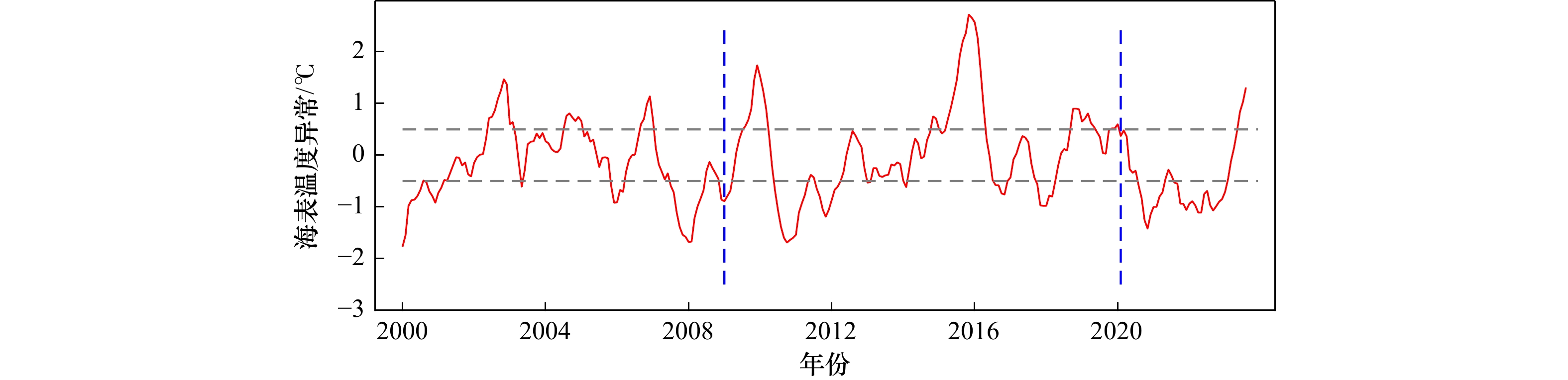
The intraseasonal variability (ISV) associated with mesoscale eddies in the northern South China Sea has been significant. Comparing the intraseasonal variability of flow at different times helps to elucidate the influence of mesoscale eddies with various dynamic instability, therefore, this study analyzed the dynamic instability of mesoscale eddies in the spring of 2009 and 2020 in the northern South China Sea, to figure out the characteristics of intraseasonal variability. Based on mooring velocity data, it conducted kinetic spectral analysis, and the results demonstrated that the ISV with period of 10‒60 days in 2009 and the ISV with period of 30‒90 days in 2020 displayed a similar vertical feature, with strong intraseasonal signals primarily occurring in the upper layer above 200 m. Moreover, the ISV with period of 30‒90 days was the main intraseasonal component during the corresponding observation period. Lag-regression analysis and calculation of dynamic instability showed that the intraseasonal variation of spring 2009 was affected by fast-moving but weak surface mesoscale eddies, and the dynamic instability was modulated by baroclinic instability and barotropic instability. On the other hand, the intraseasonal variability in the spring of 2020 was influenced by strong baroclinic mesoscale eddies, which might trigger the occurrence of intraseasonal variability in the flow fields more rapidly through enhanced vertical shear of velocity. The findings of this study contribute to a deeper understanding of the impact mechanisms of mesoscale eddies on intraseasonal activities in the northern South China Sea, providing important references and a theoretical basis for ocean dynamics and climate research.
The intraseasonal variability (ISV) associated with mesoscale eddies in the northern South China Sea has been significant. Comparing the intraseasonal variability of flow at different times helps to elucidate the influence of mesoscale eddies with various dynamic instability, therefore, this study analyzed the dynamic instability of mesoscale eddies in the spring of 2009 and 2020 in the northern South China Sea, to figure out the characteristics of intraseasonal variability. Based on mooring velocity data, it conducted kinetic spectral analysis, and the results demonstrated that the ISV with period of 10‒60 days in 2009 and the ISV with period of 30‒90 days in 2020 displayed a similar vertical feature, with strong intraseasonal signals primarily occurring in the upper layer above 200 m. Moreover, the ISV with period of 30‒90 days was the main intraseasonal component during the corresponding observation period. Lag-regression analysis and calculation of dynamic instability showed that the intraseasonal variation of spring 2009 was affected by fast-moving but weak surface mesoscale eddies, and the dynamic instability was modulated by baroclinic instability and barotropic instability. On the other hand, the intraseasonal variability in the spring of 2020 was influenced by strong baroclinic mesoscale eddies, which might trigger the occurrence of intraseasonal variability in the flow fields more rapidly through enhanced vertical shear of velocity. The findings of this study contribute to a deeper understanding of the impact mechanisms of mesoscale eddies on intraseasonal activities in the northern South China Sea, providing important references and a theoretical basis for ocean dynamics and climate research.


2023, 45(12): 13-24.
doi: 10.12284/hyxb2023161
Abstract:
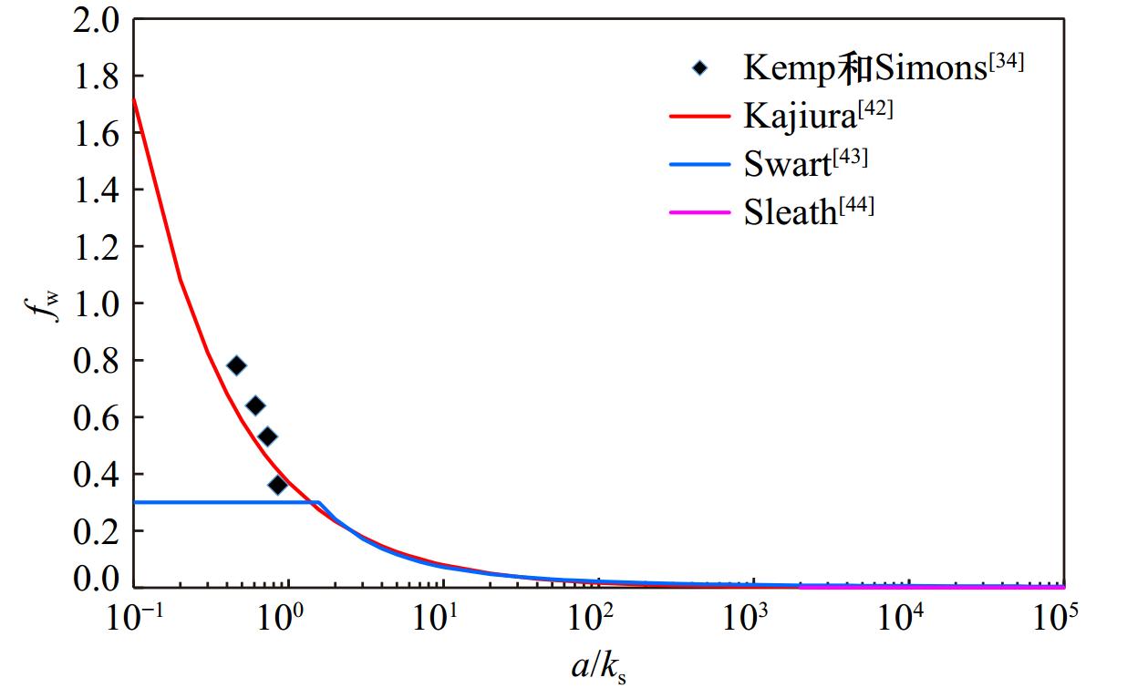
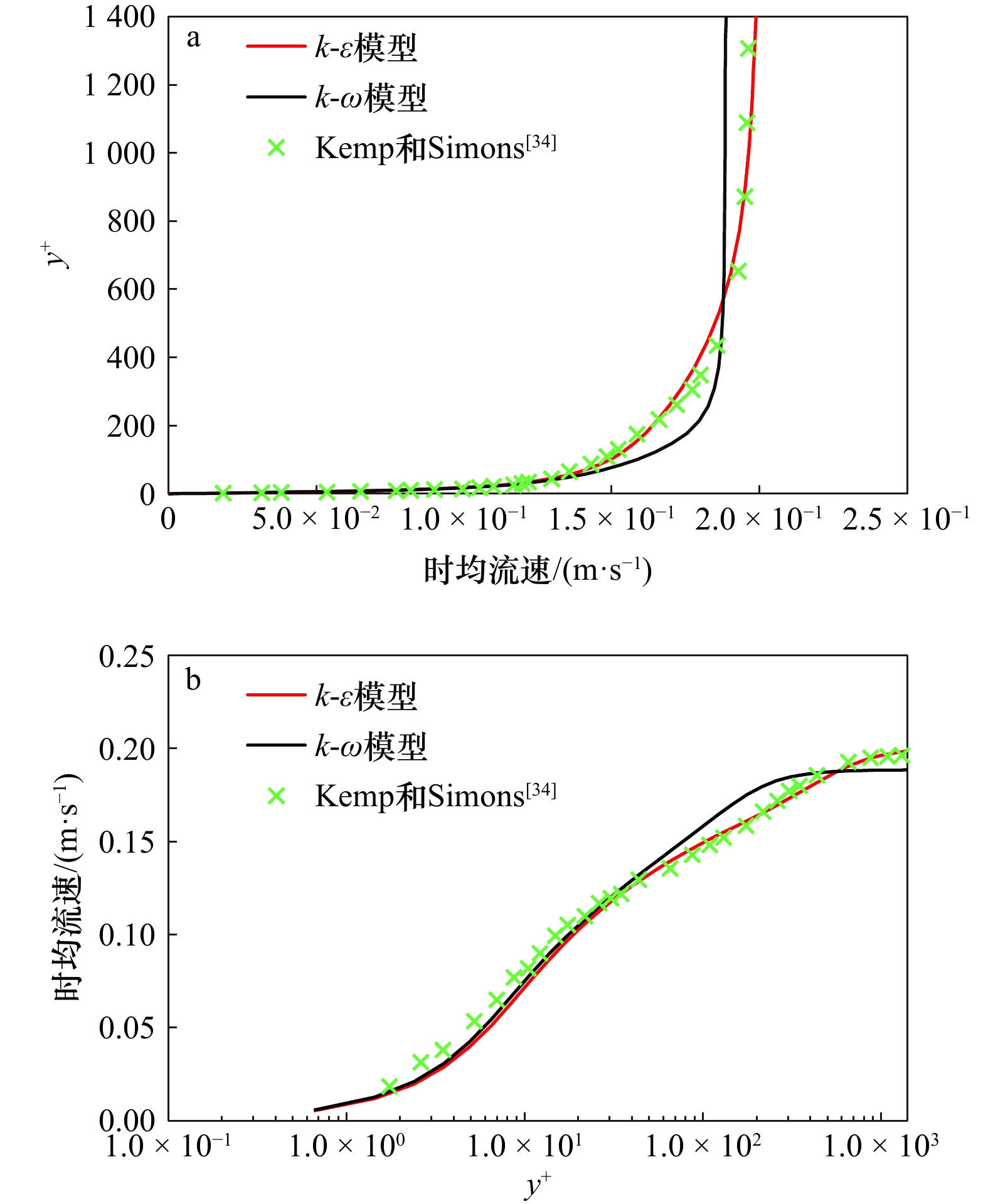
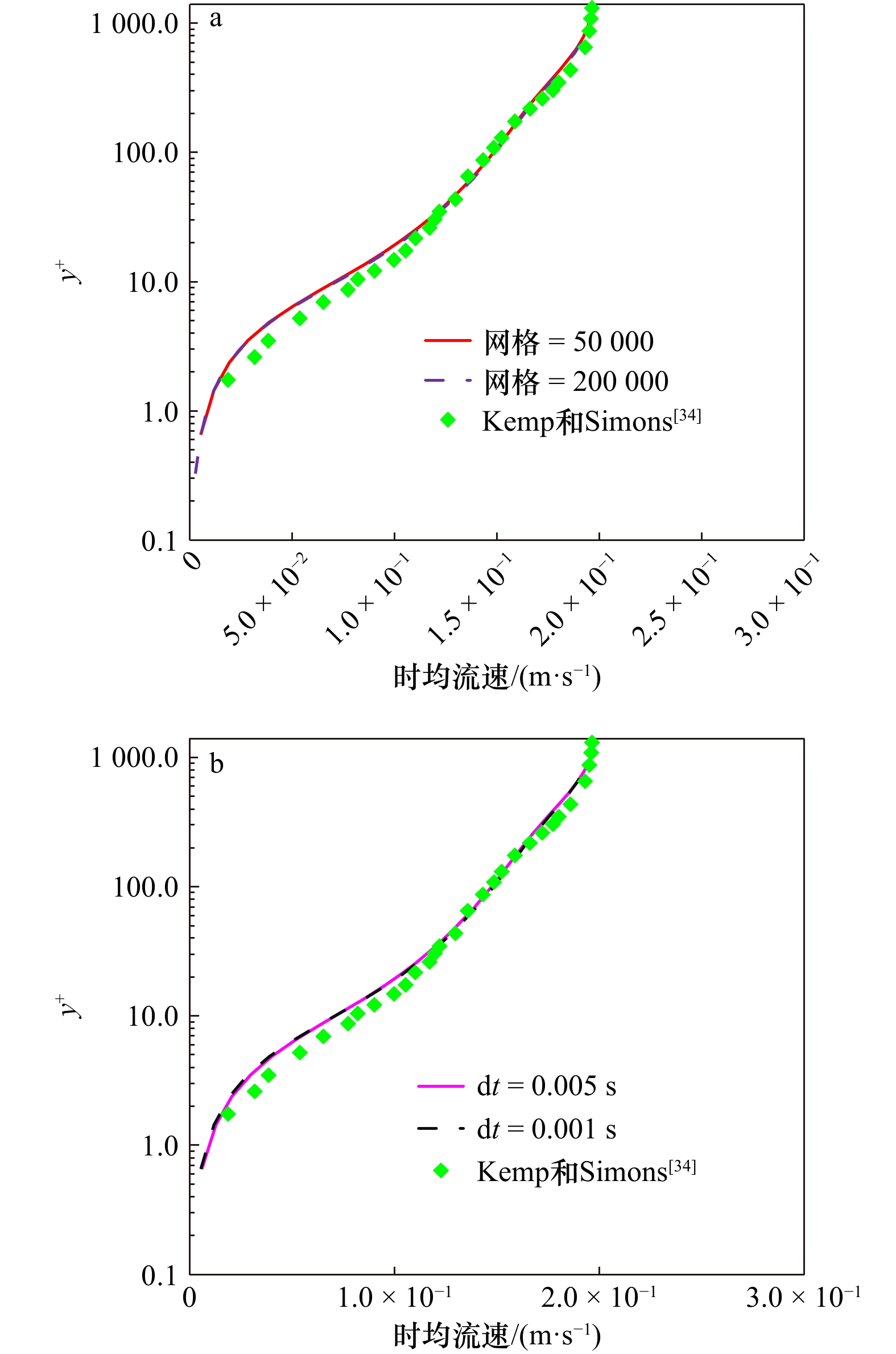
This paper investigates the characteristics of turbulent structures in combined wave-current boundary layers based on the standard\begin{document}$ k $\end{document} ![]()
![]()
\begin{document}$ \varepsilon $\end{document} ![]()
![]()
This paper investigates the characteristics of turbulent structures in combined wave-current boundary layers based on the standard


2023, 45(12): 25-43.
doi: 10.12284/hyxb2023165
Abstract:
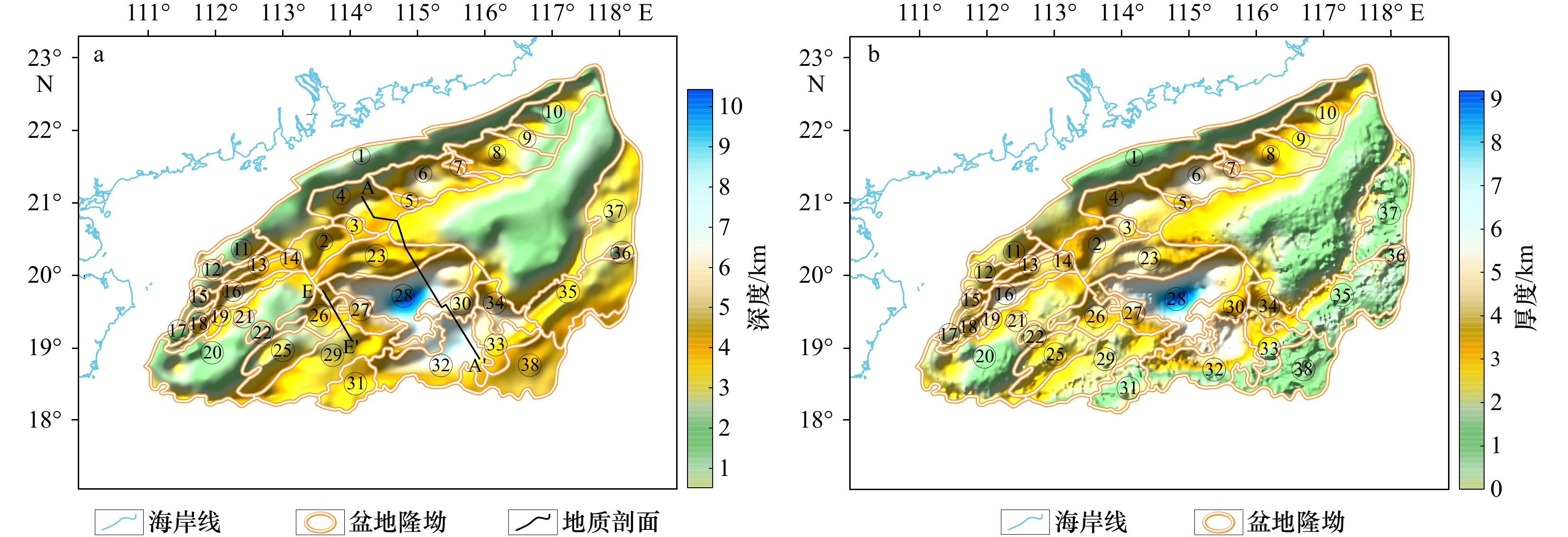
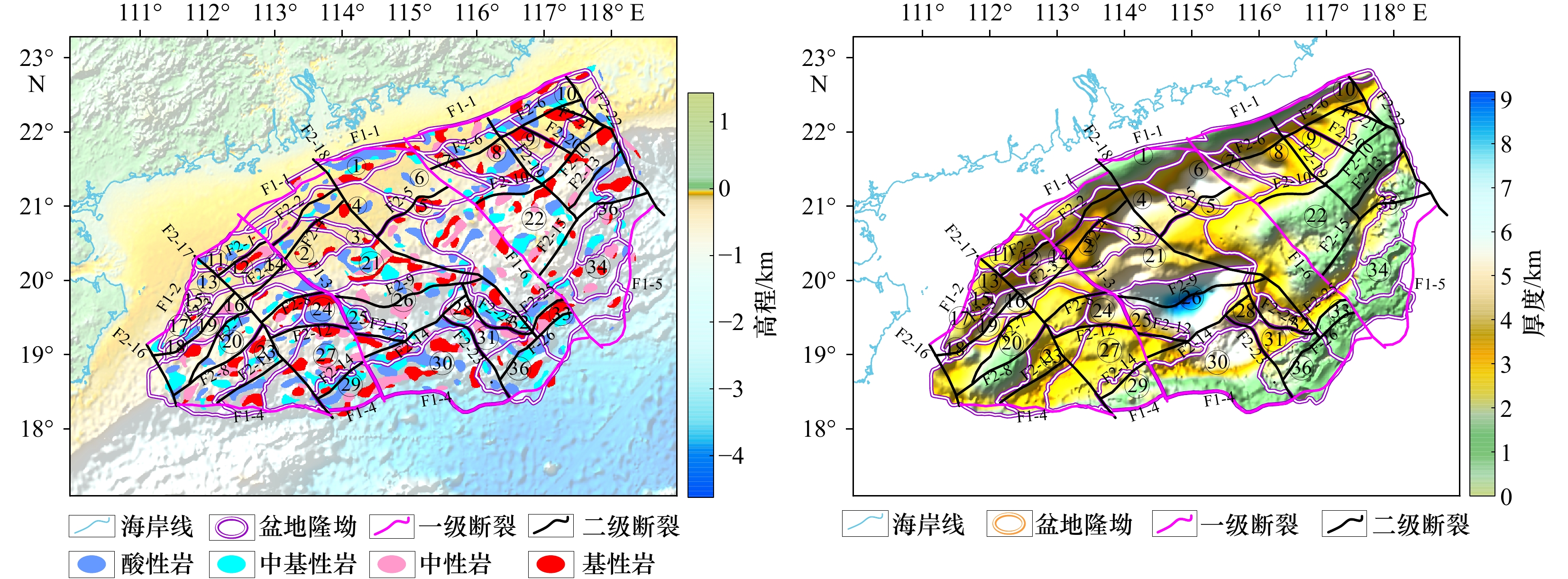
The Zhujiang River Mouth Basin is located in the northern shelf of the South China Sea, and its tectonic evolution is very complicated. At the same time, as one of the hydrocarbon-rich basins in offshore China, Zhujiang River Mouth Basin ranks the top in oil and gas production among the offshore basins. With the deepening of exploration, the boundary of the Zhujiang River Mouth Basin has been changing, and the southern boundary of the basin is disputed. In this paper, based on satellite gravity and magnetic anomaly data, the fault distribution of Zhujiang River Mouth Basin is re-studied and the plane location of igneous rocks is identified. The Cenozoic thickness of the study area is retrieved with high-precision seismic data, and the tectonic units of the study area are adjusted according to the processing results. The results show that the fault distribution in the study area is mainly NEE, NE and NW trending. In this study, four new faults were identified based on the satellite gravity data. The overall strike of the igneous rocks in the plane is NEE strike, but there are differences among different regional strikes. There are nearly EW trending igneous rocks in the western basin, NWW trending igneous rocks in the central basin, and no other strike in the eastern basin. According to gravity data and Cenozoic characteristics, Yangjiang Sag is divided into Yangjiang West Sag and Yangjiang East Sag, and Wenchang D Sag and Wenchang E Sag are deleted. The Beiweitan Fault is the same as the Yangjiang-Yitong Fault, which divides the basin into three parts: the west, the middle and the east. The fault strike, the plane position of igneous rock, the thickness of Cenozoic and the tectonic units of the three parts are different. The study of faults, igneous rocks and tectonic units in Zhujiang River Mouth Basin aims to provide geophysical support for subsequent basin research and oil and gas breakthrough.
The Zhujiang River Mouth Basin is located in the northern shelf of the South China Sea, and its tectonic evolution is very complicated. At the same time, as one of the hydrocarbon-rich basins in offshore China, Zhujiang River Mouth Basin ranks the top in oil and gas production among the offshore basins. With the deepening of exploration, the boundary of the Zhujiang River Mouth Basin has been changing, and the southern boundary of the basin is disputed. In this paper, based on satellite gravity and magnetic anomaly data, the fault distribution of Zhujiang River Mouth Basin is re-studied and the plane location of igneous rocks is identified. The Cenozoic thickness of the study area is retrieved with high-precision seismic data, and the tectonic units of the study area are adjusted according to the processing results. The results show that the fault distribution in the study area is mainly NEE, NE and NW trending. In this study, four new faults were identified based on the satellite gravity data. The overall strike of the igneous rocks in the plane is NEE strike, but there are differences among different regional strikes. There are nearly EW trending igneous rocks in the western basin, NWW trending igneous rocks in the central basin, and no other strike in the eastern basin. According to gravity data and Cenozoic characteristics, Yangjiang Sag is divided into Yangjiang West Sag and Yangjiang East Sag, and Wenchang D Sag and Wenchang E Sag are deleted. The Beiweitan Fault is the same as the Yangjiang-Yitong Fault, which divides the basin into three parts: the west, the middle and the east. The fault strike, the plane position of igneous rock, the thickness of Cenozoic and the tectonic units of the three parts are different. The study of faults, igneous rocks and tectonic units in Zhujiang River Mouth Basin aims to provide geophysical support for subsequent basin research and oil and gas breakthrough.


2023, 45(12): 44-57.
doi: 10.12284/hyxb2023103
Abstract:
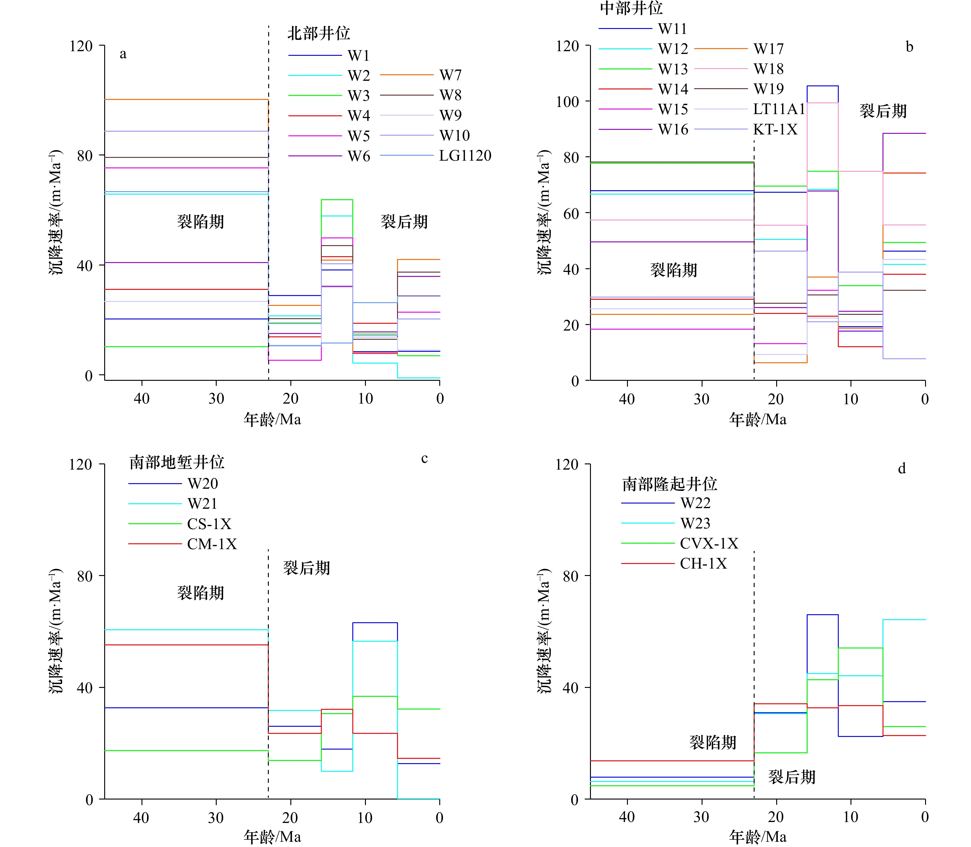
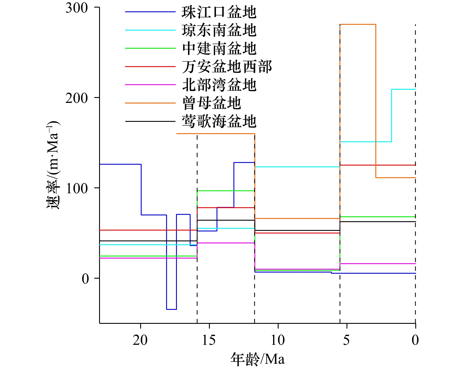
The tectonic evolution of the northwestern continental margin of the South China Sea were controlled by many factors, such as the Red River Fault, the Hainan mantle plume and the formation and evolution of the South China Sea. The Yinggehai Basin is located in the northwest of the South China Sea, where thick Cenozoic sediments were deposited. The Cenozoic evolution history of the northwestern continental margin of the South China Sea was recorded in detail in the Yinggehai Basin. However, which factor has mainly controlled the evolution of the Yinggehai Basin since the Cenozoic is still ambiguous. In this paper, 7 drilling wells and 23 simulated wells were selected in the Yinggehai Basin, and the sedimentation rate and subsidence rate of the Yinggehai Basin were reconstructed by empty basin tectonic subsidence analysis method. The deep structure of the Yinggehai Basin was simulated by gravity inversion method based on previous study. The results show that during the rift period, the subsidence rate of the Yinggehai Basin in the north and middle sections is larger than in the south section. There are two stages of “step acceleration subsidence” in the north and middle sections, which are 23–11.7 Ma BP and 11.7 Ma BP–present, respectively. The maximum tectonic subsidence rate can be up to 80 m/Ma in the post rift stage in the north section and about 110 m/Ma in the middle section. The maximum tectonic subsidence rate of the Southern Graben and Uplift is both close to 70 m/Ma during the periods of 11.7–5.7 Ma BP and 15.9–11.7 Ma BP, respectively. The Cenozoic subsidence of the Yinggehai Basin is consistent with the change of sedimentary rate, indicates that tectonic subsidence plays a significant role on sedimentary evolution. According to the results of gravity inversion, it may be lower crust high density anomaly intrusion underlying the Yinggehai Basin. We suggested it may be basic rock according to the drilling basalts in the sediments. By comparing with the subsidence rate of surrounding basins in the South China Sea, the acceleration subsidence in the 15.9–11.7 Ma BP may be related to the disappearance of secondary mantle convection due to the ceasing of the seafloor spreading of the South China Sea. The 5.7 Ma BP–present accelerated subsidence of the Yinggehai Basin may be related to the dextral strike-slip activity of the Red River Fault.
The tectonic evolution of the northwestern continental margin of the South China Sea were controlled by many factors, such as the Red River Fault, the Hainan mantle plume and the formation and evolution of the South China Sea. The Yinggehai Basin is located in the northwest of the South China Sea, where thick Cenozoic sediments were deposited. The Cenozoic evolution history of the northwestern continental margin of the South China Sea was recorded in detail in the Yinggehai Basin. However, which factor has mainly controlled the evolution of the Yinggehai Basin since the Cenozoic is still ambiguous. In this paper, 7 drilling wells and 23 simulated wells were selected in the Yinggehai Basin, and the sedimentation rate and subsidence rate of the Yinggehai Basin were reconstructed by empty basin tectonic subsidence analysis method. The deep structure of the Yinggehai Basin was simulated by gravity inversion method based on previous study. The results show that during the rift period, the subsidence rate of the Yinggehai Basin in the north and middle sections is larger than in the south section. There are two stages of “step acceleration subsidence” in the north and middle sections, which are 23–11.7 Ma BP and 11.7 Ma BP–present, respectively. The maximum tectonic subsidence rate can be up to 80 m/Ma in the post rift stage in the north section and about 110 m/Ma in the middle section. The maximum tectonic subsidence rate of the Southern Graben and Uplift is both close to 70 m/Ma during the periods of 11.7–5.7 Ma BP and 15.9–11.7 Ma BP, respectively. The Cenozoic subsidence of the Yinggehai Basin is consistent with the change of sedimentary rate, indicates that tectonic subsidence plays a significant role on sedimentary evolution. According to the results of gravity inversion, it may be lower crust high density anomaly intrusion underlying the Yinggehai Basin. We suggested it may be basic rock according to the drilling basalts in the sediments. By comparing with the subsidence rate of surrounding basins in the South China Sea, the acceleration subsidence in the 15.9–11.7 Ma BP may be related to the disappearance of secondary mantle convection due to the ceasing of the seafloor spreading of the South China Sea. The 5.7 Ma BP–present accelerated subsidence of the Yinggehai Basin may be related to the dextral strike-slip activity of the Red River Fault.


2023, 45(12): 58-66.
doi: 10.12284/hyxb2023175
Abstract:
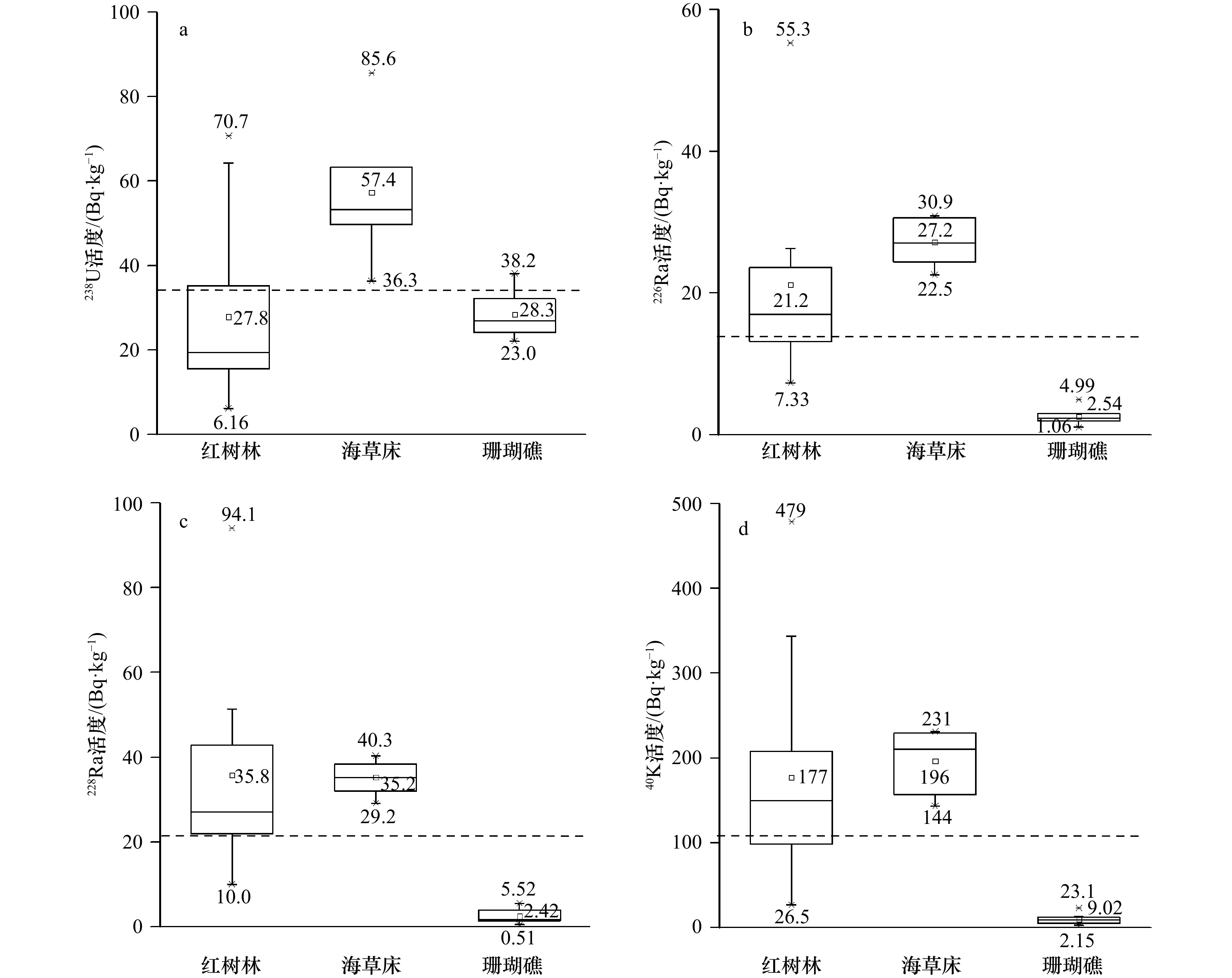
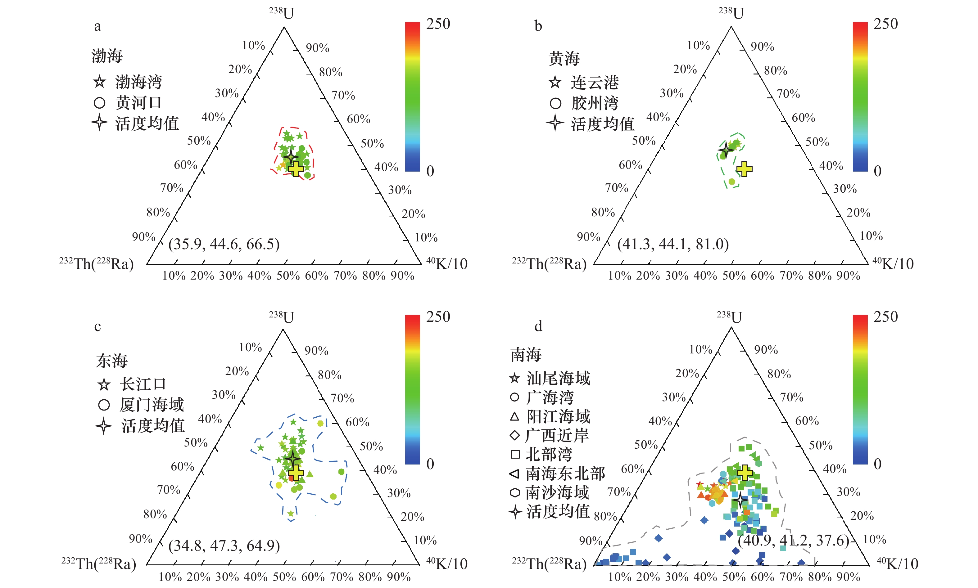
Sediment source is a key issue in sedimentology. Although sediment geochemistry is an important tool in sedimentology, the explorations and applications of radionuclides in sediment geochemistry are still limited. In this study, naturally occurring radionuclides (238U, 226Ra, 228Ra, and 40K) in sediments were simultaneously measured using a high-purity germanium γ-spectrometer in three typical ecosystems of mangrove, seagrass, and coral reefs. The distribution characteristics of radionuclides in sediments from the these ecosystems were discussed in one-dimensional view of activity level, two-dimensional view of radionuclide pairs and activity ratio, and three-dimensional view of ternary diagram of radionuclides to identify distinct sources of sediments. Ternary diagram of 238U-232Th(228Ra)-40K/10 in sediments was applied in the China different seas for tracking distinct sediment sources. This study emphasized that the three-dimensional view of ternary diagram of 238U-232Th(228Ra)-40K/10 comprehensively exhibited the information of activity level, composition, and spatial distribution area of radionuclides. In conclusion, ternary diagram of 238U-232Th(228Ra)-40K/10 may be an optimized method for source identification in sediments and provide a supplement to the existing tools of geochemical proxies.
Sediment source is a key issue in sedimentology. Although sediment geochemistry is an important tool in sedimentology, the explorations and applications of radionuclides in sediment geochemistry are still limited. In this study, naturally occurring radionuclides (238U, 226Ra, 228Ra, and 40K) in sediments were simultaneously measured using a high-purity germanium γ-spectrometer in three typical ecosystems of mangrove, seagrass, and coral reefs. The distribution characteristics of radionuclides in sediments from the these ecosystems were discussed in one-dimensional view of activity level, two-dimensional view of radionuclide pairs and activity ratio, and three-dimensional view of ternary diagram of radionuclides to identify distinct sources of sediments. Ternary diagram of 238U-232Th(228Ra)-40K/10 in sediments was applied in the China different seas for tracking distinct sediment sources. This study emphasized that the three-dimensional view of ternary diagram of 238U-232Th(228Ra)-40K/10 comprehensively exhibited the information of activity level, composition, and spatial distribution area of radionuclides. In conclusion, ternary diagram of 238U-232Th(228Ra)-40K/10 may be an optimized method for source identification in sediments and provide a supplement to the existing tools of geochemical proxies.


2023, 45(12): 67-79.
doi: 10.12284/hyxb2023157
Abstract:
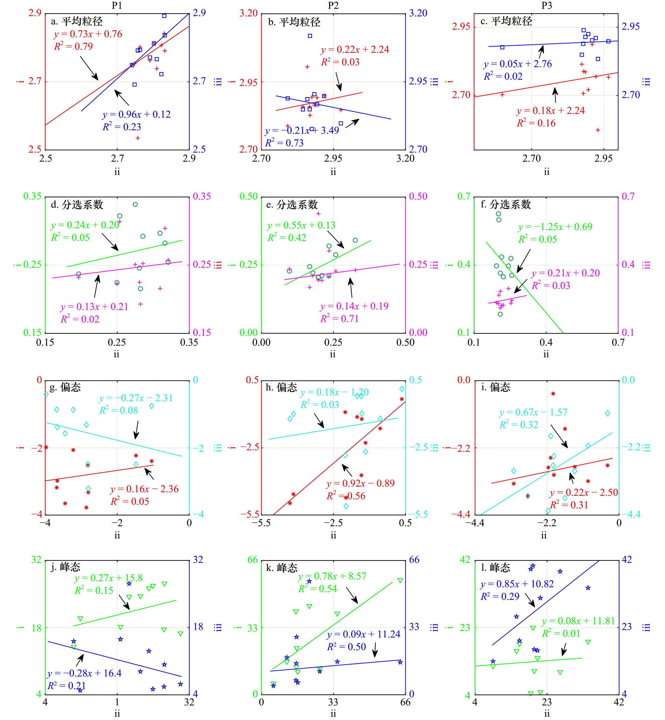
Previous research has conducted extensive work on sediment grain size testing, data analysis, and information extraction. However, studies on whether the collected sediment samples are representative are still relatively rare. Based on indicators such as the mode, median grain size, particle size distribution, sediment type, and grain size parameters, this study compared and analyzed the quantitative and qualitative results of the grain size distribution parameters of 30 parallel sediment samples collected from beaches in the southern part of Leizhou Peninsula, China. The study examined the differences, correlations, and consistencies of these parameters. The results showed that: (1) the mode, median grain size, and particle size distribution of parallel samples exhibited a certain degree of variability; (2) the skewness and kurtosis of parallel samples showed significant differences, with average values of P1 ranging from –2.90 to –1.53 and 11.23 to 21.59, P2 ranging from –2.55 to –1.52 and 11.23 to 21.59, and P3 ranging from –2.81 to –1.86 and 13.41 to 27.69; (3) about two-thirds of the combinations of grain size parameters had no correlation (R2 ≤ 0.29); (4) qualitative results of sorting coefficients, skewness, and kurtosis showed differences in 1/3, 1/2, and 4/15 of the cases, respectively. The spatial heterogeneity of sediment grain size distribution information and the randomness of sample collection are the main reasons for these differences. To minimize the randomness of sample collection and characterize the spatiotemporal heterogeneity of grain size distribution information, parallel samples are recommended for future sample collection. This study provides a typical case of comparing the results of parallel sample grain size parameters for beach sediment, which can improve our understanding of effective sediment sample collection strategies.
Previous research has conducted extensive work on sediment grain size testing, data analysis, and information extraction. However, studies on whether the collected sediment samples are representative are still relatively rare. Based on indicators such as the mode, median grain size, particle size distribution, sediment type, and grain size parameters, this study compared and analyzed the quantitative and qualitative results of the grain size distribution parameters of 30 parallel sediment samples collected from beaches in the southern part of Leizhou Peninsula, China. The study examined the differences, correlations, and consistencies of these parameters. The results showed that: (1) the mode, median grain size, and particle size distribution of parallel samples exhibited a certain degree of variability; (2) the skewness and kurtosis of parallel samples showed significant differences, with average values of P1 ranging from –2.90 to –1.53 and 11.23 to 21.59, P2 ranging from –2.55 to –1.52 and 11.23 to 21.59, and P3 ranging from –2.81 to –1.86 and 13.41 to 27.69; (3) about two-thirds of the combinations of grain size parameters had no correlation (R2 ≤ 0.29); (4) qualitative results of sorting coefficients, skewness, and kurtosis showed differences in 1/3, 1/2, and 4/15 of the cases, respectively. The spatial heterogeneity of sediment grain size distribution information and the randomness of sample collection are the main reasons for these differences. To minimize the randomness of sample collection and characterize the spatiotemporal heterogeneity of grain size distribution information, parallel samples are recommended for future sample collection. This study provides a typical case of comparing the results of parallel sample grain size parameters for beach sediment, which can improve our understanding of effective sediment sample collection strategies.


2023, 45(12): 80-91.
doi: 10.12284/hyxb2023159
Abstract:
Narrabeen Beach, located Sydney, Australia, has undergone frequent storm wave events. The beach form has an adaptive ability to evolve from storm profile to berm profile with little human intervention. In order to investigate the self-recovery capability of the headland bay after storm waves, this paper analyzes how beach evolves during the post-storm calm weathers and identify the main hydrodynamic factors that dominate the beach recovery based on the multi-year continuous measurement data of Narrabeen Beach. The results show that there are spatial differences along the shore in the recovery rates, with the fastest recovery rate in the middle of the beach. Besides, southeast breezes with small wave-height and long wave-period contribute most to the storm-profiles’ recovery, especially to the northern-to-central portion. Whilst for the southern part of the headland bay tidal force modulate the beach recovery efficiency more. Accordingly, a concept of cumulative wave energy considering tidal range is proposed by this study and found to well correlated with the self-recovery ability of the southern beach profile. Through investigation, variation of wave directions induced by topography, along with geological and geomorphological features all play a vital role on the spatial inhomogeneity of the recovery efficiency for the headland bay. In addition, from the secular time scale, the recovery ability of the storm profiles is also controlled by the Southern Oscillation Index. The analysis and findings of this paper can provide useful references for disaster prevention and mitigation, and post-disaster protection and restoration for a headland bay under extreme sea forces.
Narrabeen Beach, located Sydney, Australia, has undergone frequent storm wave events. The beach form has an adaptive ability to evolve from storm profile to berm profile with little human intervention. In order to investigate the self-recovery capability of the headland bay after storm waves, this paper analyzes how beach evolves during the post-storm calm weathers and identify the main hydrodynamic factors that dominate the beach recovery based on the multi-year continuous measurement data of Narrabeen Beach. The results show that there are spatial differences along the shore in the recovery rates, with the fastest recovery rate in the middle of the beach. Besides, southeast breezes with small wave-height and long wave-period contribute most to the storm-profiles’ recovery, especially to the northern-to-central portion. Whilst for the southern part of the headland bay tidal force modulate the beach recovery efficiency more. Accordingly, a concept of cumulative wave energy considering tidal range is proposed by this study and found to well correlated with the self-recovery ability of the southern beach profile. Through investigation, variation of wave directions induced by topography, along with geological and geomorphological features all play a vital role on the spatial inhomogeneity of the recovery efficiency for the headland bay. In addition, from the secular time scale, the recovery ability of the storm profiles is also controlled by the Southern Oscillation Index. The analysis and findings of this paper can provide useful references for disaster prevention and mitigation, and post-disaster protection and restoration for a headland bay under extreme sea forces.


2023, 45(12): 92-100.
doi: 10.12284/hyxb2023177
Abstract:
Gonadal development is a crucial process for sexual reproduction in scleractinian corals, after the gonad matured, corals will spawn in suitable environments, understanding this process is essential for predicting their spawn time. However, there is no report on the gonadal development cycle and the spawning time of corals in Weizhou Island is currently unknown. From September 2021 to May 2022, our study focused on Acropora formosa and Favites abdita in Weizhou Island to observe their gonadal development process and spawning time. In the wild, the oocytes of A. formosa began to develop in September and matured after nine months, while the testes were observed in November and matured after two to three months. In F. abdita, the onset of oocytes was between in October and November, mature oocytes were observed after seven to eight months, with the development period of the testes was about one to two months. Both corals’ gametes matured in May. In tanks, both corals were observed to spawn between May 19 to 22, 2022 ( April 19 to 22, Chinese lunar calendar), which was consistent with their spawning observed in wild. Based on the results, we postulate that the spawning time of A. formosa and F. abdita in Weizhou Island is around April 15th, Chinese lunar calendar. This study provides valuable information on the reproductive biology of Weizhou Island corals.
Gonadal development is a crucial process for sexual reproduction in scleractinian corals, after the gonad matured, corals will spawn in suitable environments, understanding this process is essential for predicting their spawn time. However, there is no report on the gonadal development cycle and the spawning time of corals in Weizhou Island is currently unknown. From September 2021 to May 2022, our study focused on Acropora formosa and Favites abdita in Weizhou Island to observe their gonadal development process and spawning time. In the wild, the oocytes of A. formosa began to develop in September and matured after nine months, while the testes were observed in November and matured after two to three months. In F. abdita, the onset of oocytes was between in October and November, mature oocytes were observed after seven to eight months, with the development period of the testes was about one to two months. Both corals’ gametes matured in May. In tanks, both corals were observed to spawn between May 19 to 22, 2022 ( April 19 to 22, Chinese lunar calendar), which was consistent with their spawning observed in wild. Based on the results, we postulate that the spawning time of A. formosa and F. abdita in Weizhou Island is around April 15th, Chinese lunar calendar. This study provides valuable information on the reproductive biology of Weizhou Island corals.


2023, 45(12): 101-111.
doi: 10.12284/hyxb2023181
Abstract:
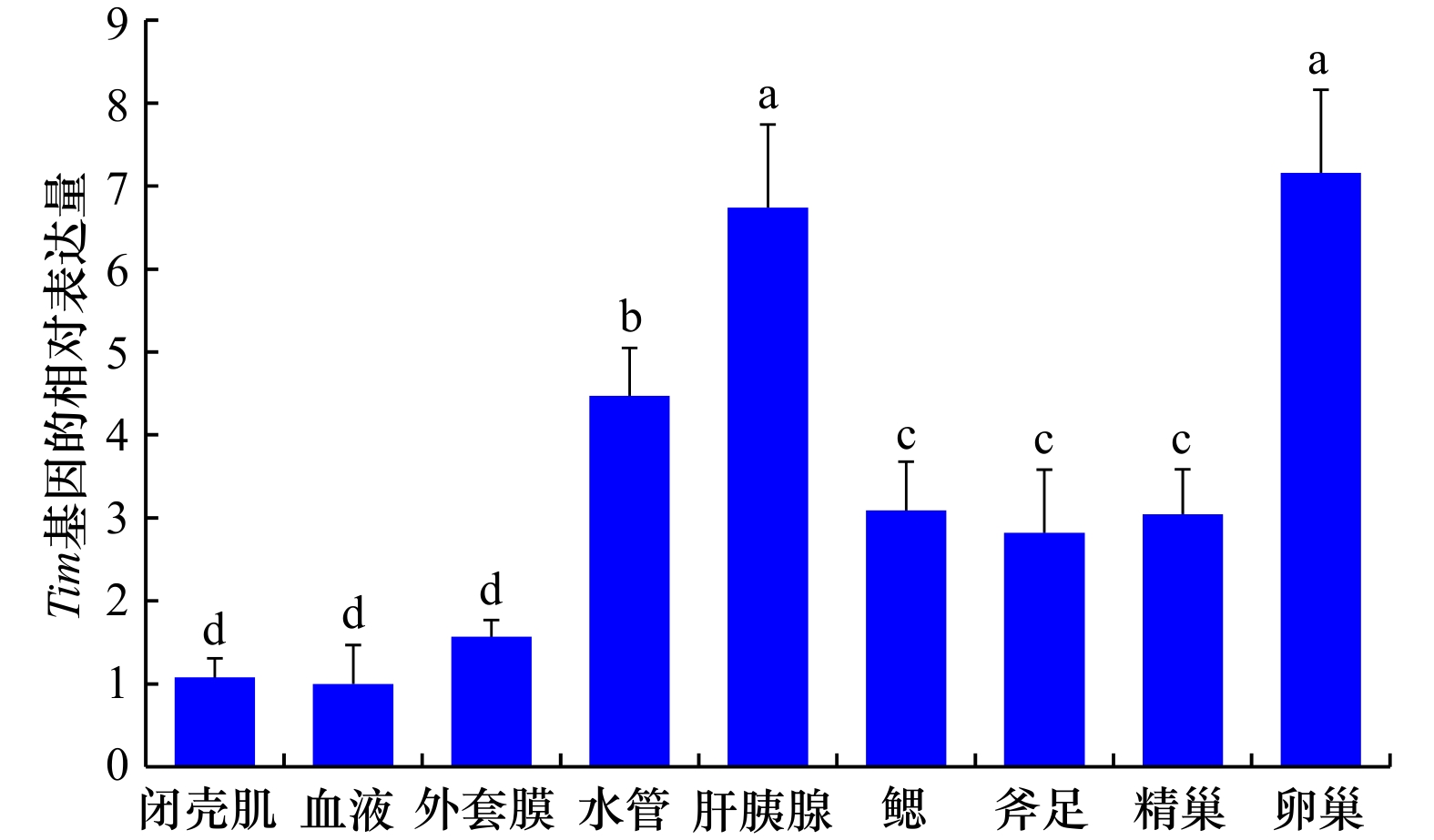
Tim (Timeless) is the second core circadian clock gene identified after the discovery of Per, which plays an important role in the regulation of animal reproduction. In order to explore the molecular mechanisms of Tim to regulate spawning in Sinonovacula constricta, the cDNA sequence of Tim was cloned and analyzed, the circadian expression patterns of Tim gene/protein in different tissues were analyzed by qRT-PCR and immunofluorescence technology, and the regulatory effects of Tim on sex hormone secretion were investigated by siRNA technology. The ORF sequence of Tim was 3 090 bp, encoding 1 029 amino acids and containing three conserved domains (TIMELESS superfamily、TIMELESS_C and FIil). Tim was expressed in test tissues, and showed higher expression levels in the hepatopancreas, siphon, ovary and testis. The expression levels of Tim were higher at 12:00–18:00 in the daytime and lower at 00:00–06:00 in the night time, which exhibited circadian rhythmic expression patterns in the ovary and testis. Tim protein was mainly expressed in hepatocytes of the hepatopancreas, epithelial cells of siphons, mature oocytes of the ovary, and spermatids of the testis. And protein fluorescence signals of Tim were slightly stronger at 12:00 during the day than at 00:00 during the night in the ovary and testis. After siRNA injection, the expression levels of Tim significantly decreased from the 3rd to 7th day in the siRNA treatment groups of the ovary and testis (P < 0.05). Meanwhile, the contents of testosterone in the testis and estradiol in the ovary decreased significantly from the 1st to 9th day after siRNA injection (P < 0.01). Consequently, it could be concluded that Tim gene/protein exhibited circadian rhythmic expression patterns in the ovary and testis, and the contents of sex hormones significantly decreased after Tim interference, which suggested that Tim might regulate the nocturnal spawning by mediating the secretion of sex hormones in S. constricta. These findings preliminarily explored the regulatory effects of circadian clock gene Tim on nocturnal spawning of S. constricta, which will provide important application value for in-depth analysis of spawning mechanism and optimizing industrialized seedling breeding technology in mollusks.
Tim (Timeless) is the second core circadian clock gene identified after the discovery of Per, which plays an important role in the regulation of animal reproduction. In order to explore the molecular mechanisms of Tim to regulate spawning in Sinonovacula constricta, the cDNA sequence of Tim was cloned and analyzed, the circadian expression patterns of Tim gene/protein in different tissues were analyzed by qRT-PCR and immunofluorescence technology, and the regulatory effects of Tim on sex hormone secretion were investigated by siRNA technology. The ORF sequence of Tim was 3 090 bp, encoding 1 029 amino acids and containing three conserved domains (TIMELESS superfamily、TIMELESS_C and FIil). Tim was expressed in test tissues, and showed higher expression levels in the hepatopancreas, siphon, ovary and testis. The expression levels of Tim were higher at 12:00–18:00 in the daytime and lower at 00:00–06:00 in the night time, which exhibited circadian rhythmic expression patterns in the ovary and testis. Tim protein was mainly expressed in hepatocytes of the hepatopancreas, epithelial cells of siphons, mature oocytes of the ovary, and spermatids of the testis. And protein fluorescence signals of Tim were slightly stronger at 12:00 during the day than at 00:00 during the night in the ovary and testis. After siRNA injection, the expression levels of Tim significantly decreased from the 3rd to 7th day in the siRNA treatment groups of the ovary and testis (P < 0.05). Meanwhile, the contents of testosterone in the testis and estradiol in the ovary decreased significantly from the 1st to 9th day after siRNA injection (P < 0.01). Consequently, it could be concluded that Tim gene/protein exhibited circadian rhythmic expression patterns in the ovary and testis, and the contents of sex hormones significantly decreased after Tim interference, which suggested that Tim might regulate the nocturnal spawning by mediating the secretion of sex hormones in S. constricta. These findings preliminarily explored the regulatory effects of circadian clock gene Tim on nocturnal spawning of S. constricta, which will provide important application value for in-depth analysis of spawning mechanism and optimizing industrialized seedling breeding technology in mollusks.


2023, 45(12): 112-120.
doi: 10.12284/hyxb2023169
Abstract:
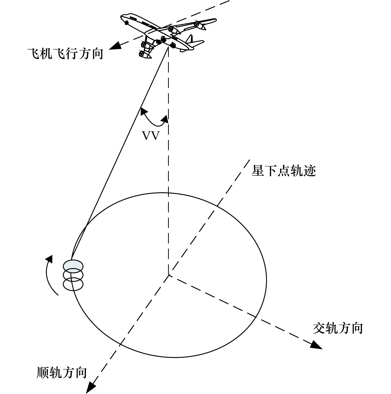
Doppler scatterometer is able to measure radar backscattering coefficient and Doppler frequency over sea surface, such that it can be used to retrieve sea surface wind and sea surface current simultaneously. This paper performs a study on the joint wind and current retrieval based on the observation data from an airborne Doppler scatterometer, which results are compared with those of independent retrieval. The results indicate that the accuracy of sea surface current is significantly improved by introducing the radar backscattering coefficients into the joint inversion method, however, the accuracy of the retrieved wind field from the joint inversion method is slightly lower than that of the independent wind inversion, compared to the European Centre for Medium-Range Weather Forecasts winds. This implies that the Doppler information has little influence on the wind retrieval, while the radar backscattering coefficients (the wind) have a remarkable impact on the sea surface current retrieval. The joint inversion algorithm can mitigates the effects of sea surface wind for the current retrieval. The results of this study provide a new insight to the interplay between wind inversion and current retrieval, and also provide a reference for the data processing of spaceborne Doppler scatterometer.
Doppler scatterometer is able to measure radar backscattering coefficient and Doppler frequency over sea surface, such that it can be used to retrieve sea surface wind and sea surface current simultaneously. This paper performs a study on the joint wind and current retrieval based on the observation data from an airborne Doppler scatterometer, which results are compared with those of independent retrieval. The results indicate that the accuracy of sea surface current is significantly improved by introducing the radar backscattering coefficients into the joint inversion method, however, the accuracy of the retrieved wind field from the joint inversion method is slightly lower than that of the independent wind inversion, compared to the European Centre for Medium-Range Weather Forecasts winds. This implies that the Doppler information has little influence on the wind retrieval, while the radar backscattering coefficients (the wind) have a remarkable impact on the sea surface current retrieval. The joint inversion algorithm can mitigates the effects of sea surface wind for the current retrieval. The results of this study provide a new insight to the interplay between wind inversion and current retrieval, and also provide a reference for the data processing of spaceborne Doppler scatterometer.


2023, 45(12): 121-132.
doi: 10.12284/hyxb2023107
Abstract:
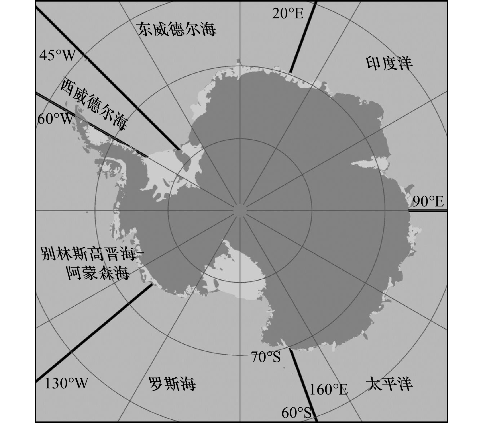
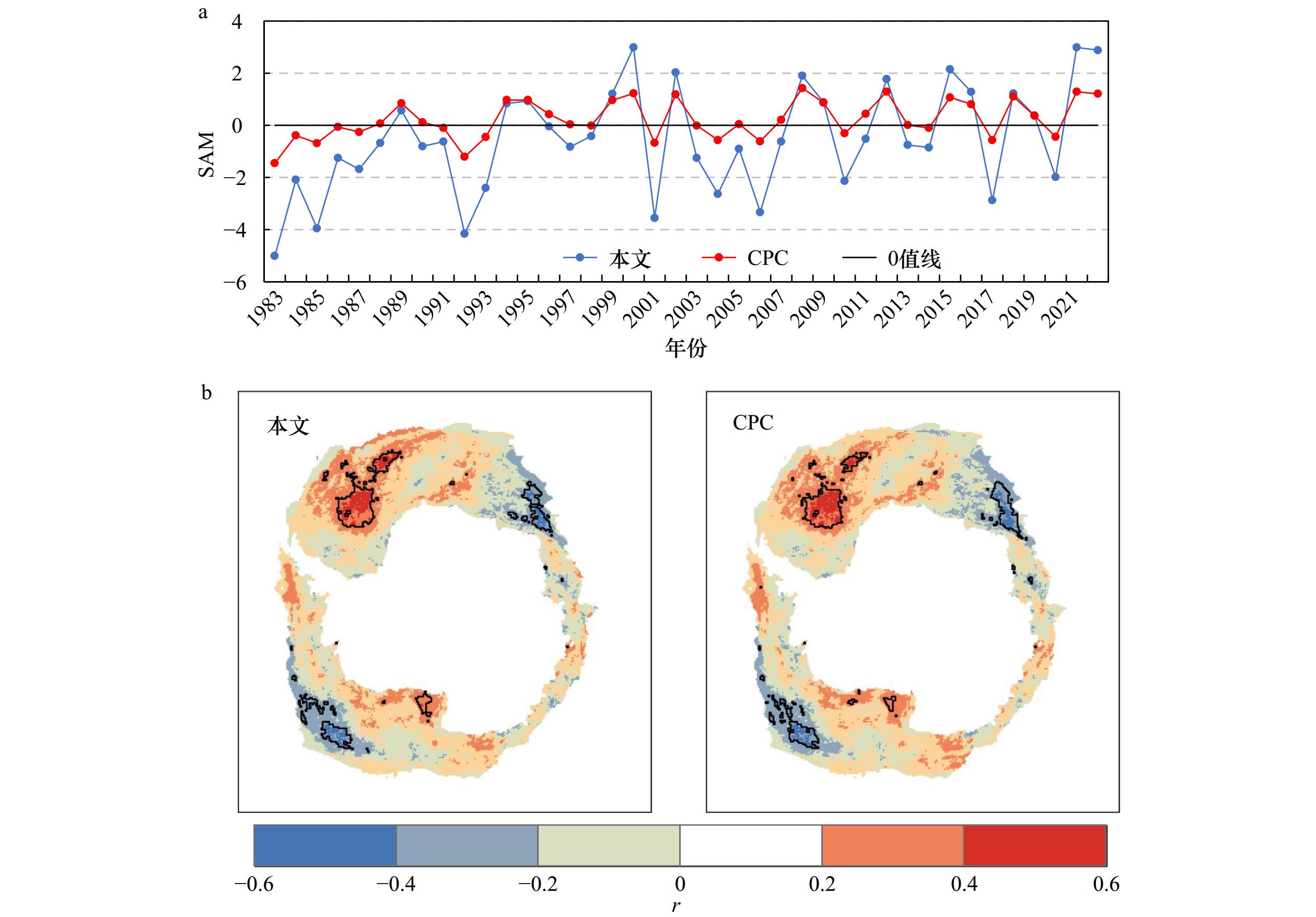
The albedo of Antarctic sea-ice zone (ASZ) can affect the radiation budget and thus has essential influence on global climate change. Using the albedo product from satellite application facility on climate monitoring, the spatio-temporal variations of summer albedo in sea-ice zone from 1983 to 2022 in Antarctica and six sea sectors were analyzed, the relationships between ASZ albedo and sea ice concentration (SIC), air temperature and atmospheric circulation were also quantified. Results show that the albedo retrieved from satellite is consistent to that obtained from in situ observations and thus the satellite-based albedo is reliable. Among the six sea sectors, Weddell West has the highest multi-year averaged albedo of 0.61, whilst Ross Sea features the lowest one of 0.45. Albedo of ASZ in summer experienced gradual increases before 2015 followed by the rapid decline (2015–2022). All sea sectors have similar ASZ albedo variations to that of Antarctica, excepting for Bellingshausen-Amundsen Seas where decreases can be found in both two periods. ASZ albedo is positively correlated to SIC and negatively related to air temperature. From 1983 to 2015, the decreased summer air temperature weakened the sea ice ablation and the SIC increased slightly (0.03%/a), sea ice area increased by 2.07 × 10⁵ km2 per decade on average, all of these led to the increase of reflected solar radiation and sea-ice zone albedo. During the summer from 2015 to 2022, as the increased temperature enhanced the sea ice ablation, more leads and open water appeared, and then decreased the SIC. The sea-ice zone thus absorbed more solar radiation and had less reflected radiation, which leads to a rapid decline of the albedo. In addition, the Antarctic annular mode is one of the driving factors changing the albedo in sea-ice zone in the Ross Sea and Weddell Sea.
The albedo of Antarctic sea-ice zone (ASZ) can affect the radiation budget and thus has essential influence on global climate change. Using the albedo product from satellite application facility on climate monitoring, the spatio-temporal variations of summer albedo in sea-ice zone from 1983 to 2022 in Antarctica and six sea sectors were analyzed, the relationships between ASZ albedo and sea ice concentration (SIC), air temperature and atmospheric circulation were also quantified. Results show that the albedo retrieved from satellite is consistent to that obtained from in situ observations and thus the satellite-based albedo is reliable. Among the six sea sectors, Weddell West has the highest multi-year averaged albedo of 0.61, whilst Ross Sea features the lowest one of 0.45. Albedo of ASZ in summer experienced gradual increases before 2015 followed by the rapid decline (2015–2022). All sea sectors have similar ASZ albedo variations to that of Antarctica, excepting for Bellingshausen-Amundsen Seas where decreases can be found in both two periods. ASZ albedo is positively correlated to SIC and negatively related to air temperature. From 1983 to 2015, the decreased summer air temperature weakened the sea ice ablation and the SIC increased slightly (0.03%/a), sea ice area increased by 2.07 × 10⁵ km2 per decade on average, all of these led to the increase of reflected solar radiation and sea-ice zone albedo. During the summer from 2015 to 2022, as the increased temperature enhanced the sea ice ablation, more leads and open water appeared, and then decreased the SIC. The sea-ice zone thus absorbed more solar radiation and had less reflected radiation, which leads to a rapid decline of the albedo. In addition, the Antarctic annular mode is one of the driving factors changing the albedo in sea-ice zone in the Ross Sea and Weddell Sea.


2023, 45(12): 133-144.
doi: 10.12284/hyxb2023163
Abstract:
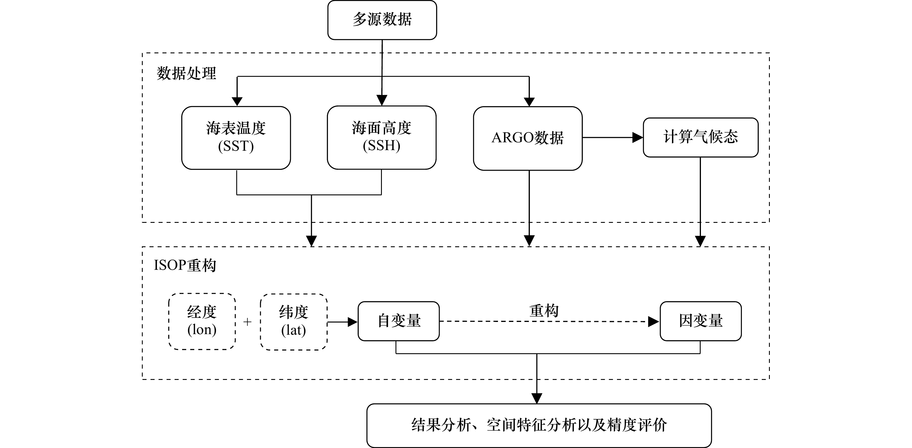
Research on the reconstruction of underwater three-dimensional temperature and salinity fields and the acquisition of acoustic field characteristics based on satellite sea surface observations has significant practical value in military oceans and other fields. However, its effectiveness not only depends on the reconstruction method but also changes with different sea surface observations used. Although there are few reports on related research, it has significant guiding value for the design of satellite sea surface observation schemes. In this study, based on the latest variational method applied by the US Navy, the influence of the vertical gradient of temperature and salinity and the sea surface height, sea surface temperature, and their joint use on the reconstruction of three-dimensional temperature and salinity and acoustic field characteristics were investigated. The results showed that the reconstruction scheme incorporating the three constraint items had the highest accuracy, with average reconstruction errors of 1.08℃ for temperature field and 0.11 for salinity field, and could better capture the spatial features of the temperature and salinity fields. By analyzing the spatial characteristics of different schemes, the sea surface temperature mainly plays a role in capturing the temperature and salinity characteristics of the shallow region of the mixing layer, which has a great influence on the Sound Layer Depth (SLD). Both the sea surface height and the vertical gradient of warm salt field can improve the inversion accuracy of mixed layer and deep area, which can affect the accuracy of the whole sound velocity profile. According to the analysis of acoustic characteristics, when SST, SSH, and the gradient were constrained simultaneously, the SLD had the smallest difference from HYCOM in the shallow sound speed, which was about 1 m/s. When there was no gradient constraint, the SLD differed significantly from HYCOM and failed to reflect the surface duct characteristics. It can be seen that the surface duct is more sensitive to sea surface temperature and gradient constraints.
Research on the reconstruction of underwater three-dimensional temperature and salinity fields and the acquisition of acoustic field characteristics based on satellite sea surface observations has significant practical value in military oceans and other fields. However, its effectiveness not only depends on the reconstruction method but also changes with different sea surface observations used. Although there are few reports on related research, it has significant guiding value for the design of satellite sea surface observation schemes. In this study, based on the latest variational method applied by the US Navy, the influence of the vertical gradient of temperature and salinity and the sea surface height, sea surface temperature, and their joint use on the reconstruction of three-dimensional temperature and salinity and acoustic field characteristics were investigated. The results showed that the reconstruction scheme incorporating the three constraint items had the highest accuracy, with average reconstruction errors of 1.08℃ for temperature field and 0.11 for salinity field, and could better capture the spatial features of the temperature and salinity fields. By analyzing the spatial characteristics of different schemes, the sea surface temperature mainly plays a role in capturing the temperature and salinity characteristics of the shallow region of the mixing layer, which has a great influence on the Sound Layer Depth (SLD). Both the sea surface height and the vertical gradient of warm salt field can improve the inversion accuracy of mixed layer and deep area, which can affect the accuracy of the whole sound velocity profile. According to the analysis of acoustic characteristics, when SST, SSH, and the gradient were constrained simultaneously, the SLD had the smallest difference from HYCOM in the shallow sound speed, which was about 1 m/s. When there was no gradient constraint, the SLD differed significantly from HYCOM and failed to reflect the surface duct characteristics. It can be seen that the surface duct is more sensitive to sea surface temperature and gradient constraints.


2023, 45(12): 145-155.
doi: 10.12284/hyxb2023167
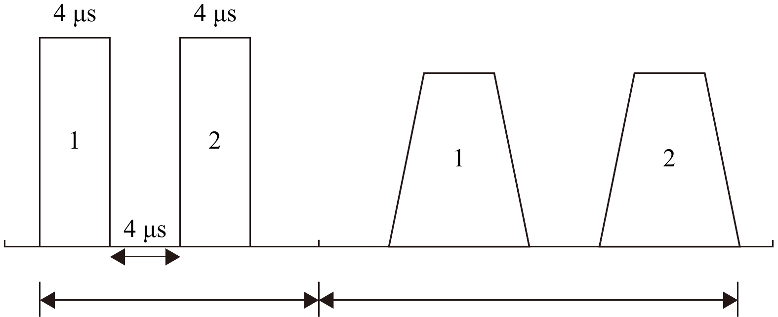
Abstract:
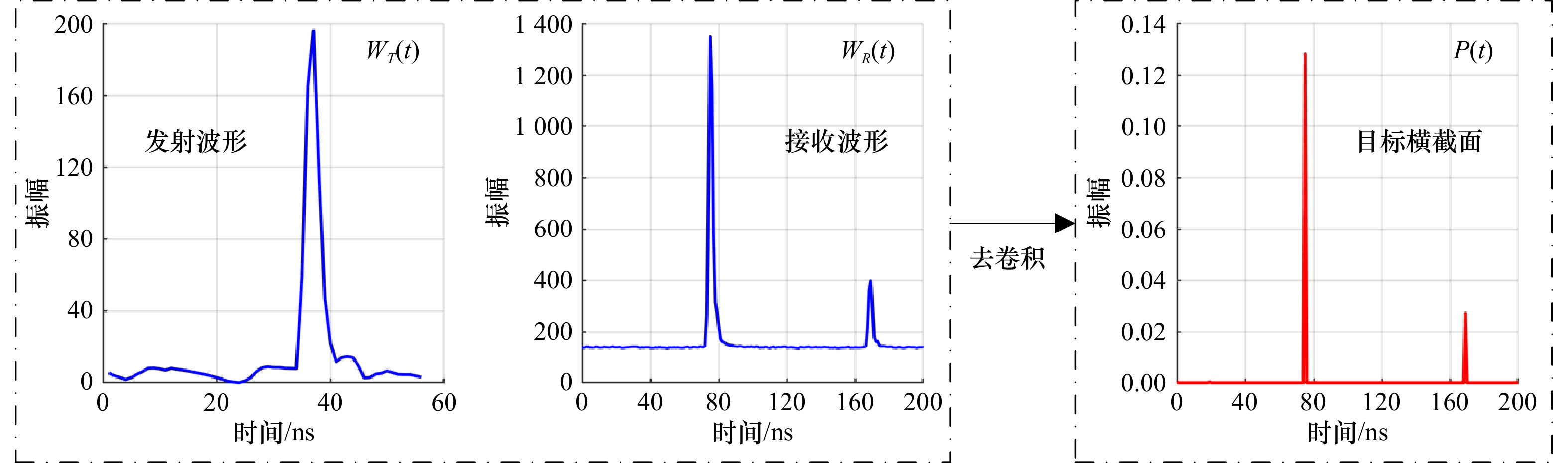
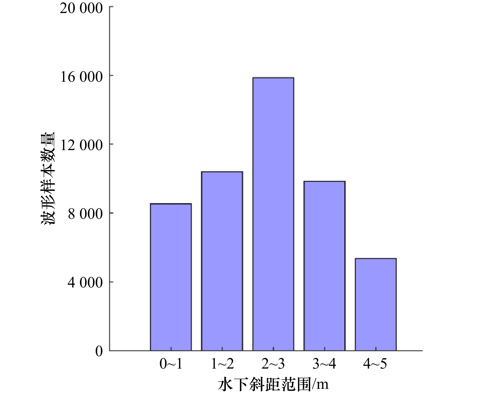
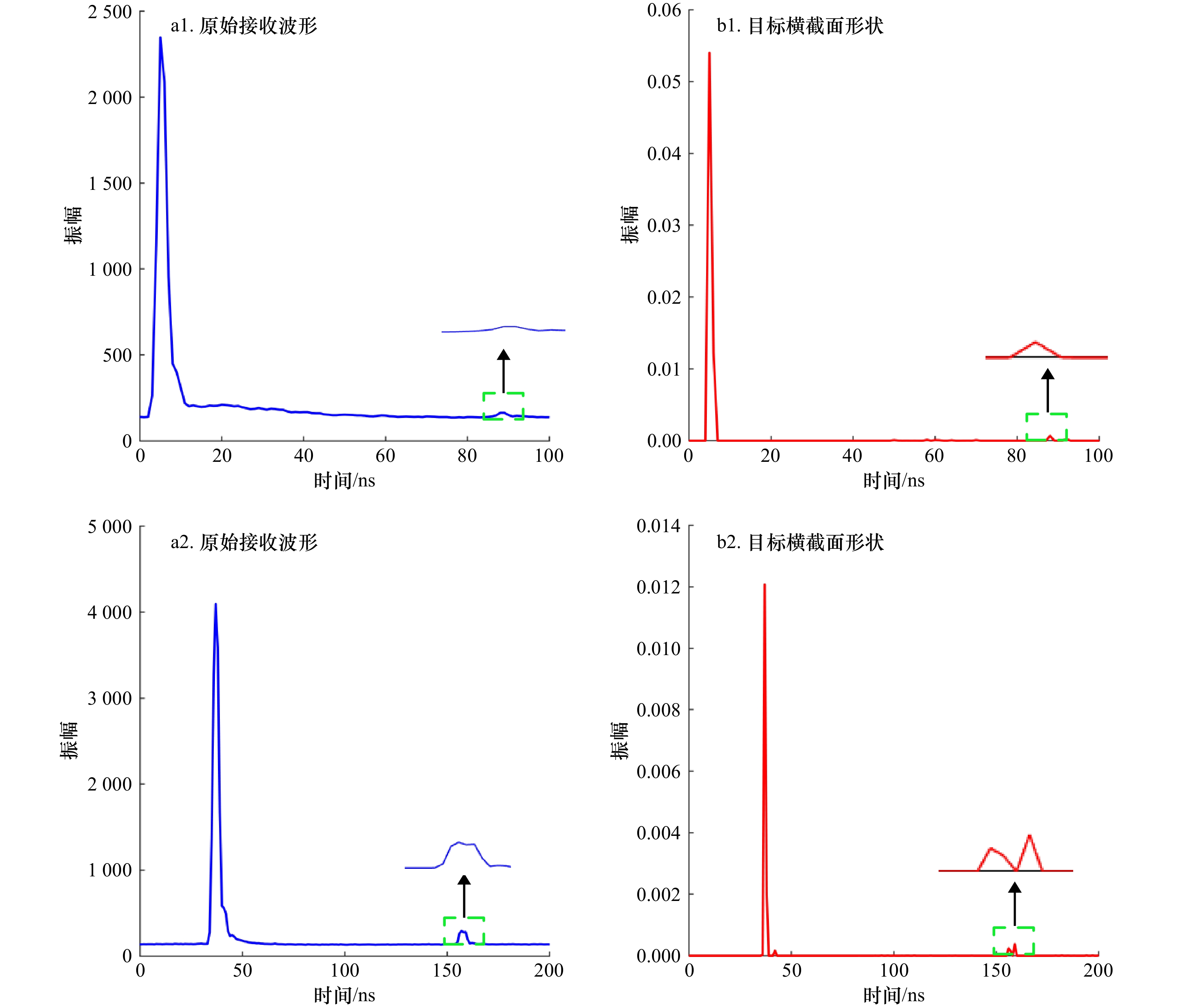
The airborne LiDAR bathymetry (ALB) technology has the advantages of high precision, high efficiency, strong mobility and dual use of water and land. It is especially suitable for the rapid detection of complex terraforming in shallow waters such as coastal zones, islands and reefs. When the laser penetrates the water, the energy will attenuate rapidly, which makes it difficult to extract part of the seabed echo effectively and distinguish the true position of the sea bottom. Therefore, an airborne LiDAR bathymetric travel time in the water column extraction algorithm based on echo enhancement is proposed in this paper. The Gold deconvolution algorithm was used to restore the cross section shape of the target and determine the initial range of the seabed. Then, the effective range of backscattering was fitted by double exponential function, and the diffuse attenuation coefficient Kd was obtained. Finally, combined with the seabed LiDAR equation, the waveform in the initial range of the seabed is enhanced by Kd value, and the enhanced echo is decomposed by Gaussian function to determine the seabed position parameters, so as to realize the travel time in the water column extraction of ALB waveform. The feasibility of the proposed algorithm was verified by using the experimental data of RIEGL VQ-840-G ALB in Qingdao Jiaozhou Bay, and the proposed algorithm was compared with the Richardson-Lucy deconvolution model and the peak detection model. The results show that the root mean square error (RMSE) between the proposed algorithm and the single-beam point with the same name is 18.5 cm, which is 29.9% and 41.4% lower than the above two algorithms, respectively. Therefore, the proposed algorithm is feasible and can satisfy the high precision extraction of ALB waveform during water column traveling, which can provide certain technical support for the fine processing of airborne LiDAR bathymetry data.
The airborne LiDAR bathymetry (ALB) technology has the advantages of high precision, high efficiency, strong mobility and dual use of water and land. It is especially suitable for the rapid detection of complex terraforming in shallow waters such as coastal zones, islands and reefs. When the laser penetrates the water, the energy will attenuate rapidly, which makes it difficult to extract part of the seabed echo effectively and distinguish the true position of the sea bottom. Therefore, an airborne LiDAR bathymetric travel time in the water column extraction algorithm based on echo enhancement is proposed in this paper. The Gold deconvolution algorithm was used to restore the cross section shape of the target and determine the initial range of the seabed. Then, the effective range of backscattering was fitted by double exponential function, and the diffuse attenuation coefficient Kd was obtained. Finally, combined with the seabed LiDAR equation, the waveform in the initial range of the seabed is enhanced by Kd value, and the enhanced echo is decomposed by Gaussian function to determine the seabed position parameters, so as to realize the travel time in the water column extraction of ALB waveform. The feasibility of the proposed algorithm was verified by using the experimental data of RIEGL VQ-840-G ALB in Qingdao Jiaozhou Bay, and the proposed algorithm was compared with the Richardson-Lucy deconvolution model and the peak detection model. The results show that the root mean square error (RMSE) between the proposed algorithm and the single-beam point with the same name is 18.5 cm, which is 29.9% and 41.4% lower than the above two algorithms, respectively. Therefore, the proposed algorithm is feasible and can satisfy the high precision extraction of ALB waveform during water column traveling, which can provide certain technical support for the fine processing of airborne LiDAR bathymetry data.


2023, 45(12): 156-165.
doi: 10.12284/hyxb2023155
Abstract:
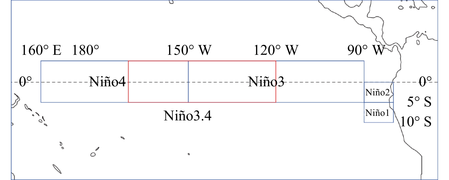
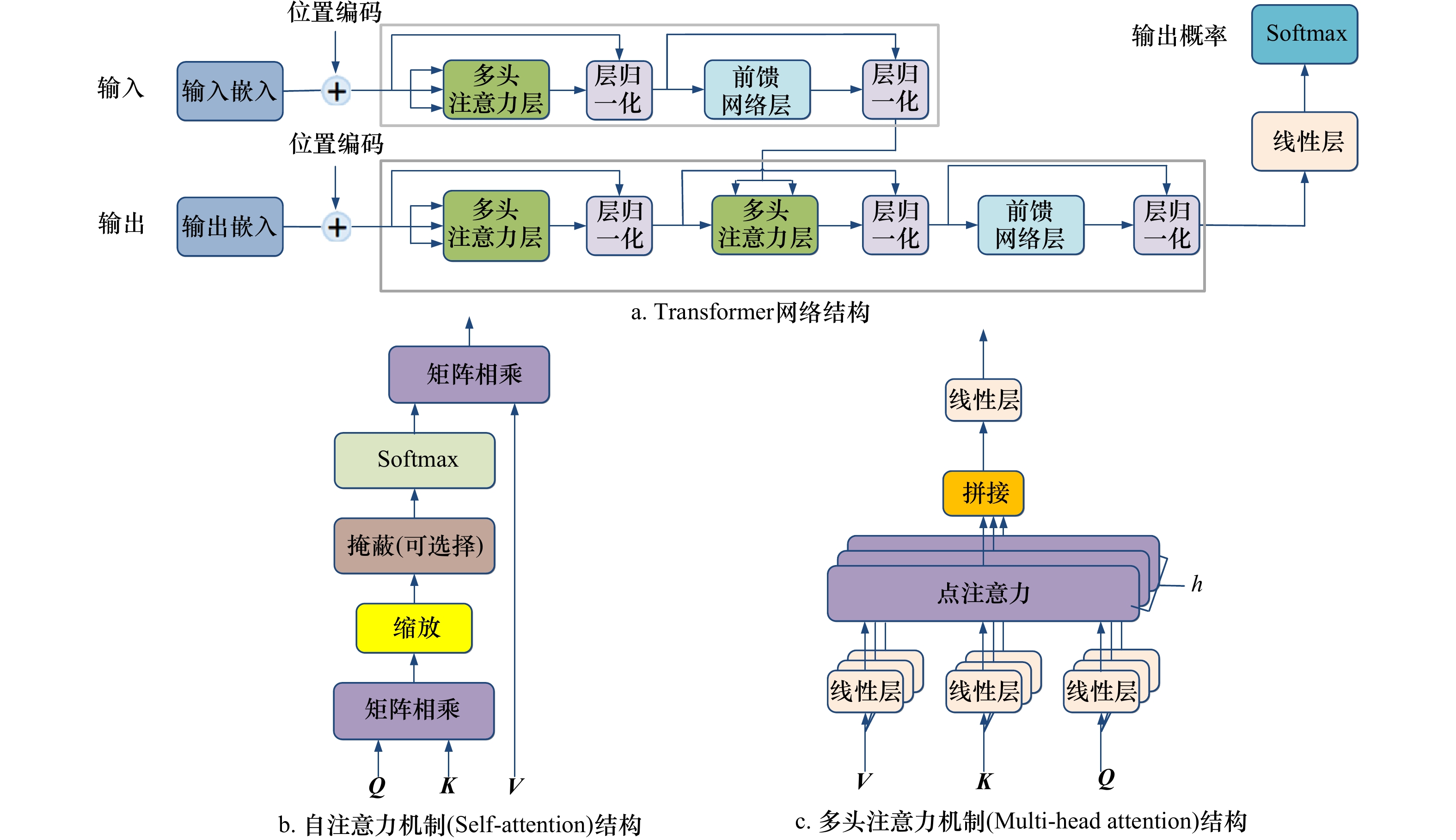
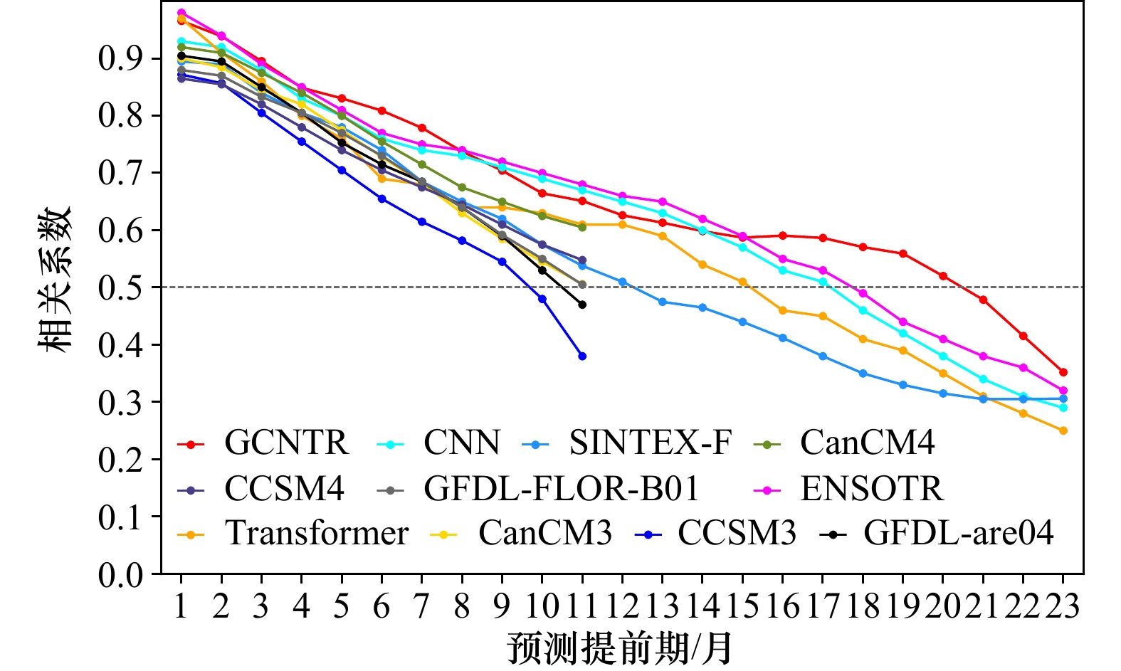
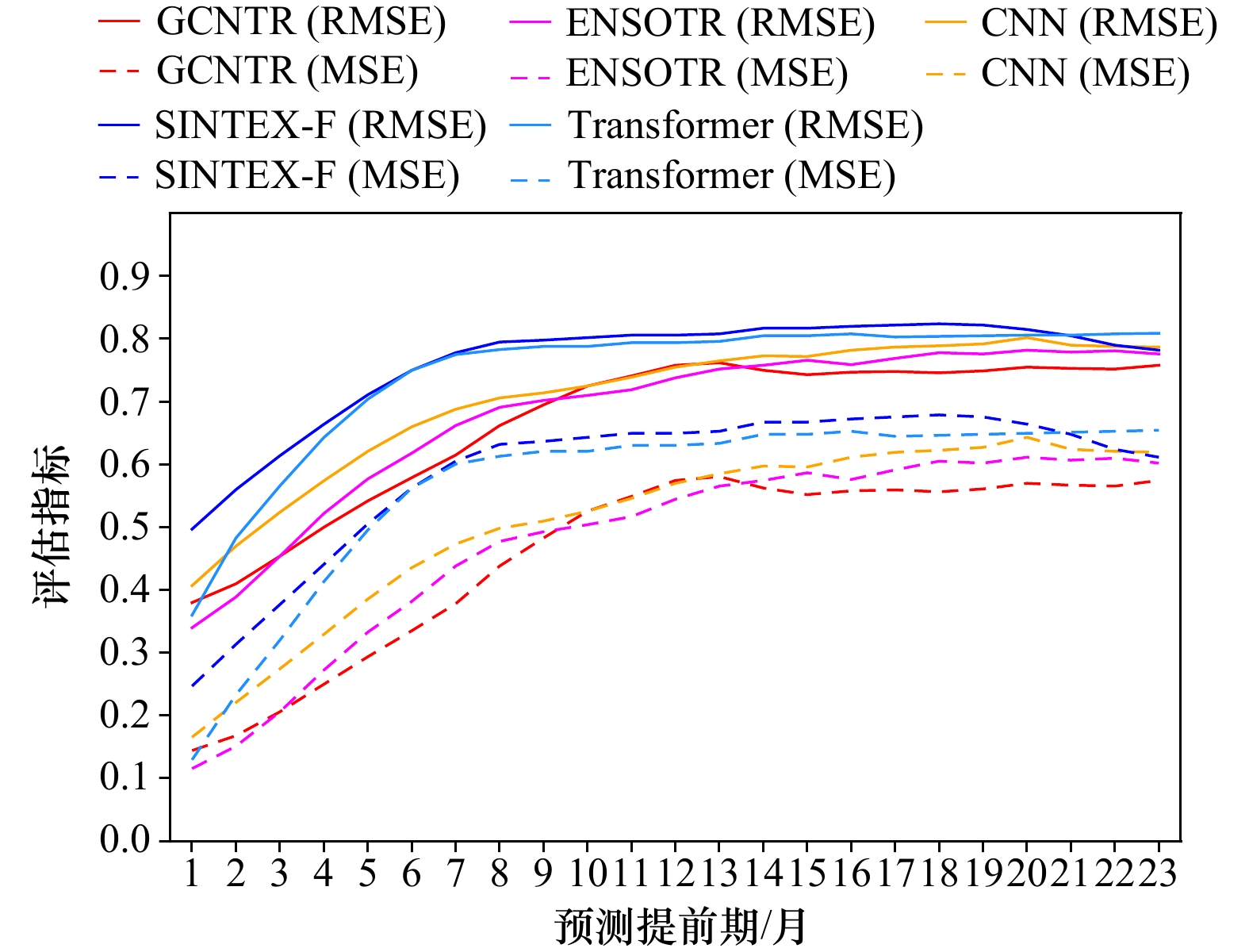
El Niño-Southern Oscillation (ENSO) is an anomaly in the Tropical Pacific Ocean sea surface that can lead to extreme weather such as hail, floods, and typhoons, therefore, accurate prediction of ENSO is of great significance. An integrated graph convolutional network-transformer (GCNTR) model is presented in this paper. Firstly, transformer network is used to encode data features based on its strong focus ability of the global feature. Secondly, GCN is employed to extract features from graph data, and finally introduces a gated feature fusion mechanism to fuse the encoded features with the features extracted by GCN to achieve the accurate prediction ENSO. The results indicate that the GCNTR model achieves the prediction of ENSO 20 months in advance, which is 3 months longer than ENSOTR and 5 months longer than Transformer, and most of the prediction accuracy of the model is better than other models. Compared to the existing methods, the GCNTR model enables better prediction of ENSO.
El Niño-Southern Oscillation (ENSO) is an anomaly in the Tropical Pacific Ocean sea surface that can lead to extreme weather such as hail, floods, and typhoons, therefore, accurate prediction of ENSO is of great significance. An integrated graph convolutional network-transformer (GCNTR) model is presented in this paper. Firstly, transformer network is used to encode data features based on its strong focus ability of the global feature. Secondly, GCN is employed to extract features from graph data, and finally introduces a gated feature fusion mechanism to fuse the encoded features with the features extracted by GCN to achieve the accurate prediction ENSO. The results indicate that the GCNTR model achieves the prediction of ENSO 20 months in advance, which is 3 months longer than ENSOTR and 5 months longer than Transformer, and most of the prediction accuracy of the model is better than other models. Compared to the existing methods, the GCNTR model enables better prediction of ENSO.


2023, 45(12): 166-178.
doi: 10.12284/hyxb2023179
Abstract:
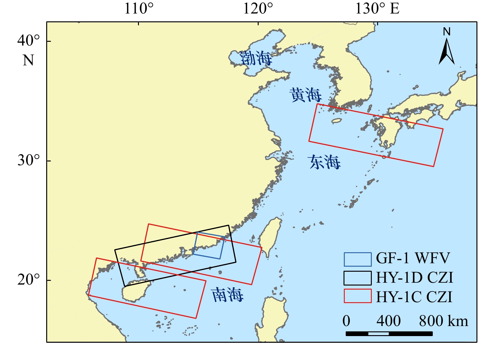
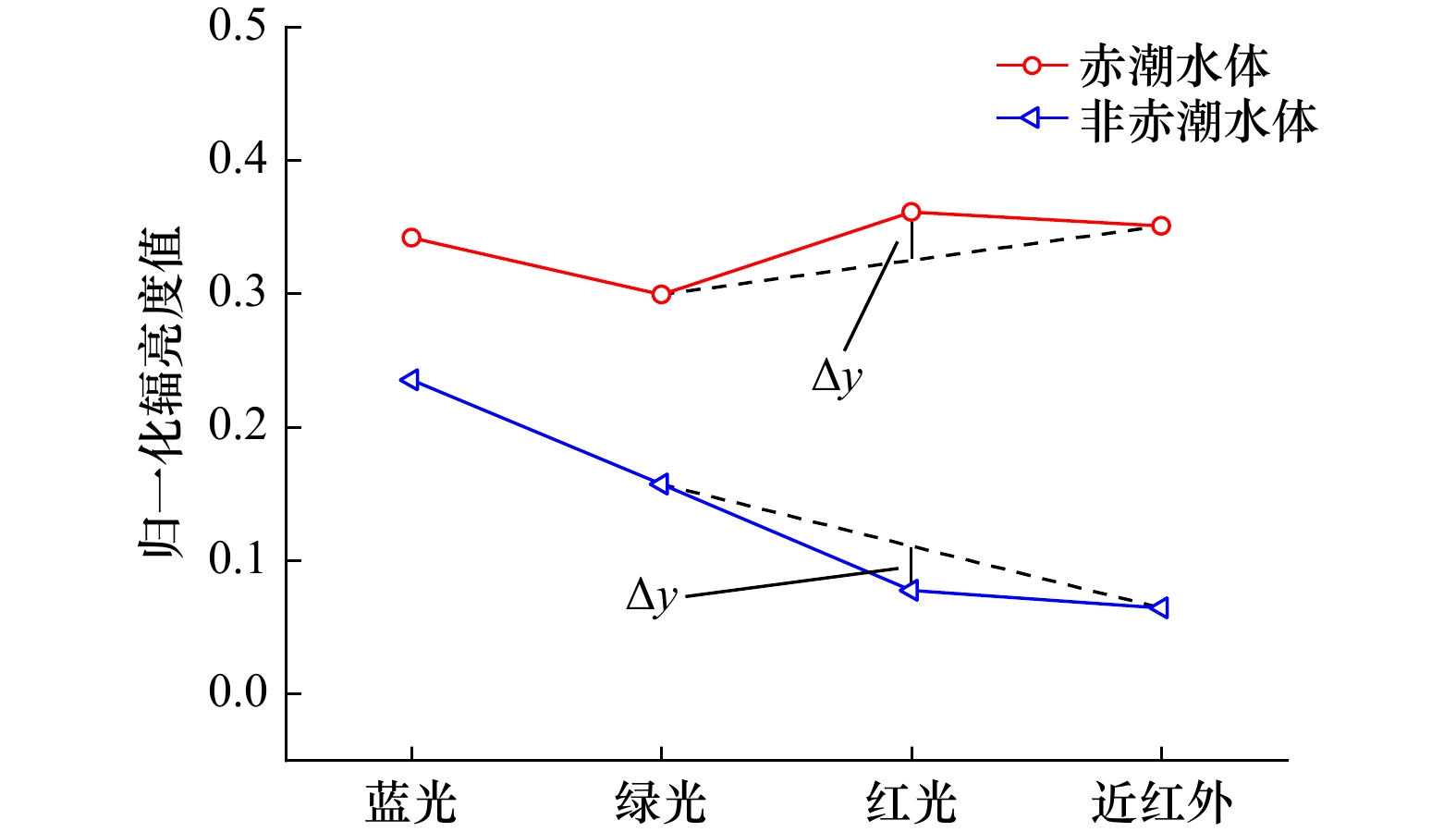
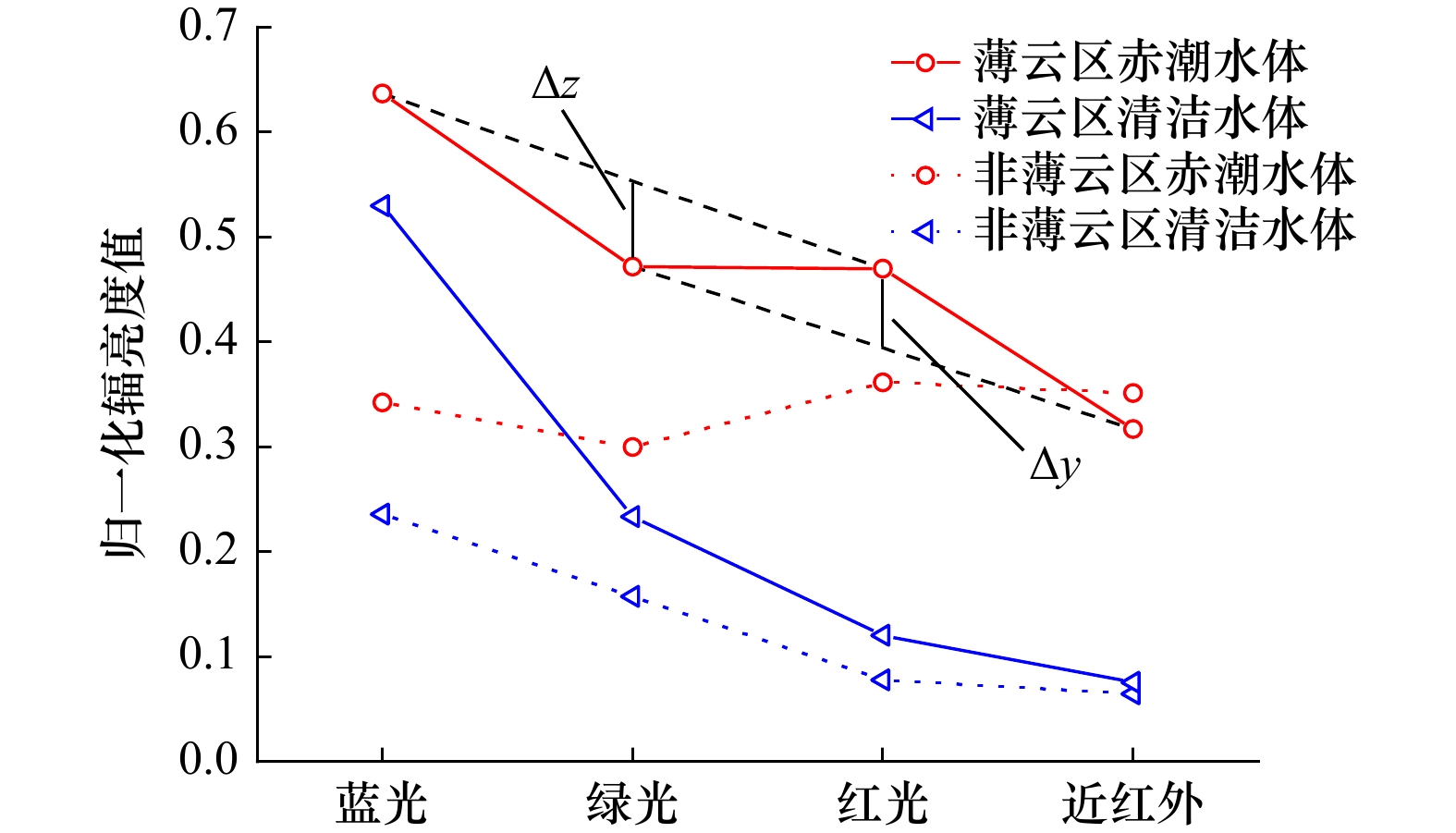
Red Noctiluca scintillans is the main red tide species in China, which often occurs in the Bohai Sea, Yellow Sea, East China Sea and South China Sea. Recently, the red N. scintillans blooms occurred frequently, leading to an urgent need for their monitoring. However, the occurrence of red N. scintillans blooms is characterized by wide distribution range, rapid change and strip distribution. Therefore, the high spatial resolution, large coverage and short revisit period satellites are needed for red N. scintillans blooms monitoring. Although, ocean color satellites have played an important role in red tide detection, they cannot detect the strip distributed red N. scintillans blooms for their low spatial resolution. The Coastal Zone Imager (CZI) onboard HY-1C/D satellite, with high spatial resolution, wide swath and short revisit cycle, has been increasingly used for red tide monitoring. Most existing red N. scintillans blooms detection methods for HY-1C/D CZI are based on deep learning methods, which need a large number of training samples. However, the training samples are difficult to obtain, which affects the accuracy of the models. Therefore, taking red N. scintillans bloom occurred in the Honghai Bay, Guangdong Province in March 2022 as an example, the spectral features of red N. scintillans blooms were analyzed in this paper, the red tide detection method based on the high reflectance features of red N. scintillans blooms in the red and near infrared bands and turbid water in the green band was constructed for HY-1C/D CZI. The experimental results show that based on the method, red N. scintillans blooms can be detected effectively in the turbid water, with precision and F1-Score of 89.72% and 0.90 respectively. Moreover, the method has good applicability, and it is proved to be suitable for the detection of red N. scintillans blooms in different marine environments. Also, it is applicable to different broad band sensors.
Red Noctiluca scintillans is the main red tide species in China, which often occurs in the Bohai Sea, Yellow Sea, East China Sea and South China Sea. Recently, the red N. scintillans blooms occurred frequently, leading to an urgent need for their monitoring. However, the occurrence of red N. scintillans blooms is characterized by wide distribution range, rapid change and strip distribution. Therefore, the high spatial resolution, large coverage and short revisit period satellites are needed for red N. scintillans blooms monitoring. Although, ocean color satellites have played an important role in red tide detection, they cannot detect the strip distributed red N. scintillans blooms for their low spatial resolution. The Coastal Zone Imager (CZI) onboard HY-1C/D satellite, with high spatial resolution, wide swath and short revisit cycle, has been increasingly used for red tide monitoring. Most existing red N. scintillans blooms detection methods for HY-1C/D CZI are based on deep learning methods, which need a large number of training samples. However, the training samples are difficult to obtain, which affects the accuracy of the models. Therefore, taking red N. scintillans bloom occurred in the Honghai Bay, Guangdong Province in March 2022 as an example, the spectral features of red N. scintillans blooms were analyzed in this paper, the red tide detection method based on the high reflectance features of red N. scintillans blooms in the red and near infrared bands and turbid water in the green band was constructed for HY-1C/D CZI. The experimental results show that based on the method, red N. scintillans blooms can be detected effectively in the turbid water, with precision and F1-Score of 89.72% and 0.90 respectively. Moreover, the method has good applicability, and it is proved to be suitable for the detection of red N. scintillans blooms in different marine environments. Also, it is applicable to different broad band sensors.


2023, 45(12): 179-192.
doi: 10.12284/hyxb2023171
Abstract:
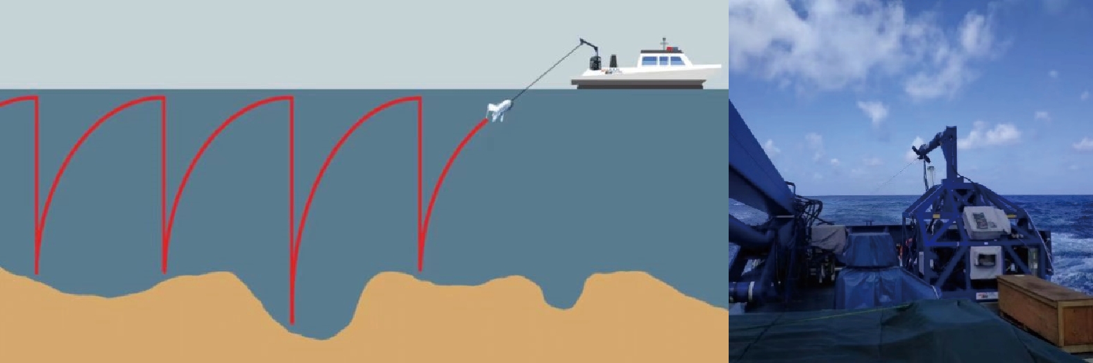
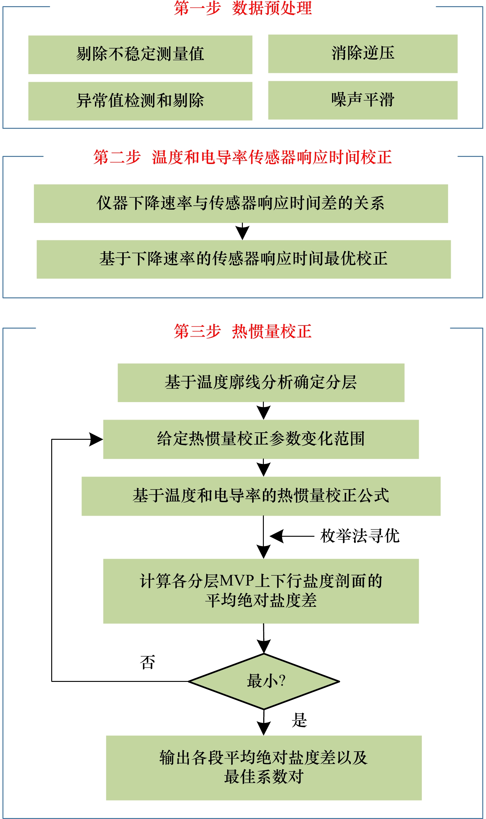
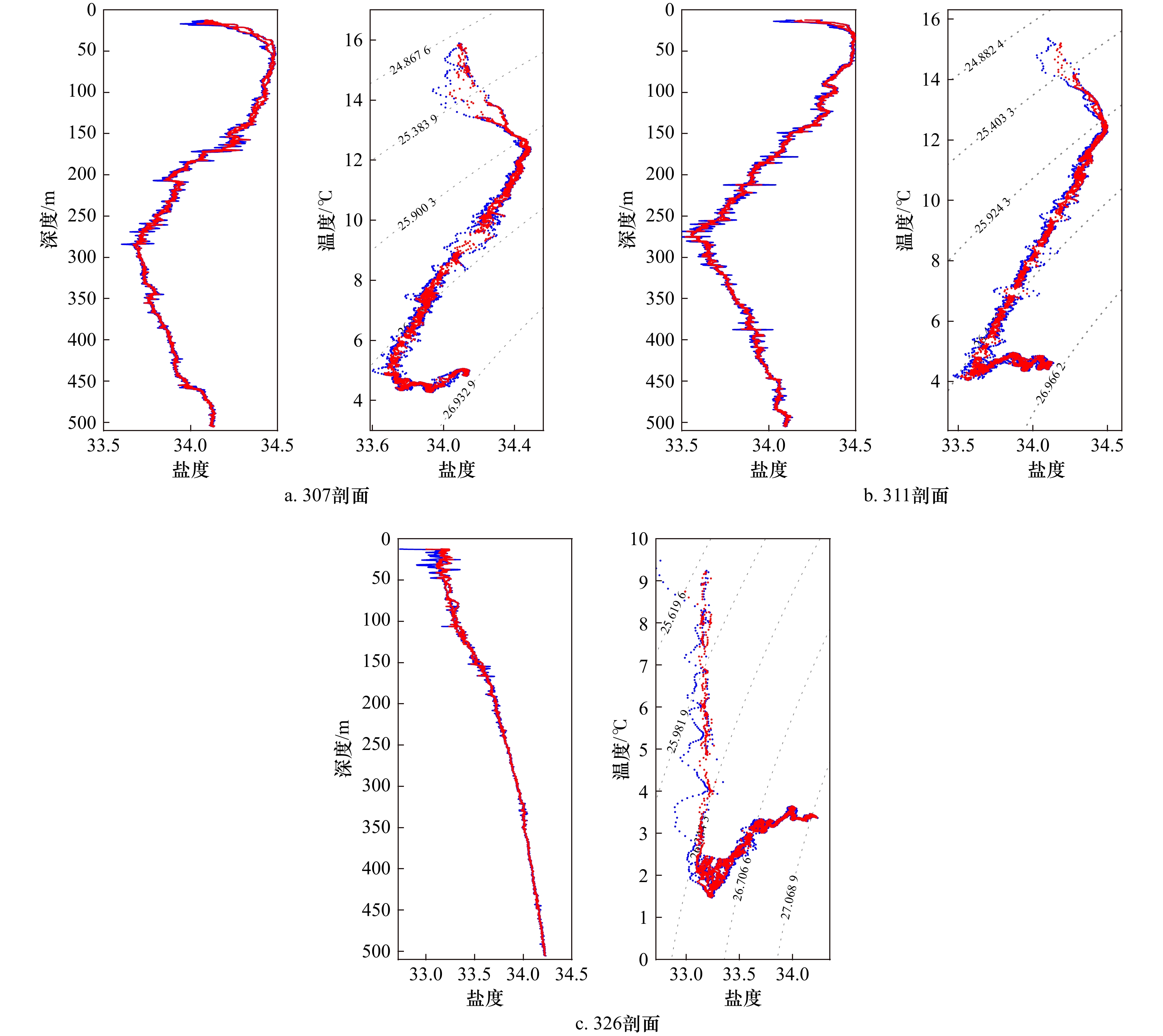
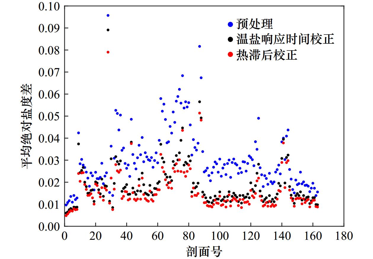
The Moving Vessel Profiler (MVP) has the advantage of acquiring temperature and salinity profiles with high spatial resolution. However, since a pumpless CTD is used for the temperature and salinity measurements, adjusting the response time of the sensor and correcting for thermal inertia are important issues in processing the measured data and complicate the application of the data. Since the existing thermal inertia correction methods still have salinity peaks at the strong thermocline, in this work we propose a layered method to optimize the thermal inertia correction parameters based on the analysis of the measured temperature gradient profile to correct the temperature and conductivity, and thus the salinity profile. The results show that the method significantly reduces the salinity difference between the upward and downward measured profiles of the MVP and essentially eliminates the salinity peaks, especially in the thermocline. The average absolute salinity difference between the upward and downward measured profiles is reduced from 0.031 to 0.016 1, which corresponds to a 48.1% reduction in salinity error and confirms the appropriateness of the salinity profile correction method proposed in this work for the MVP.
The Moving Vessel Profiler (MVP) has the advantage of acquiring temperature and salinity profiles with high spatial resolution. However, since a pumpless CTD is used for the temperature and salinity measurements, adjusting the response time of the sensor and correcting for thermal inertia are important issues in processing the measured data and complicate the application of the data. Since the existing thermal inertia correction methods still have salinity peaks at the strong thermocline, in this work we propose a layered method to optimize the thermal inertia correction parameters based on the analysis of the measured temperature gradient profile to correct the temperature and conductivity, and thus the salinity profile. The results show that the method significantly reduces the salinity difference between the upward and downward measured profiles of the MVP and essentially eliminates the salinity peaks, especially in the thermocline. The average absolute salinity difference between the upward and downward measured profiles is reduced from 0.031 to 0.016 1, which corresponds to a 48.1% reduction in salinity error and confirms the appropriateness of the salinity profile correction method proposed in this work for the MVP.


 Email alert
 RSS
RSS