

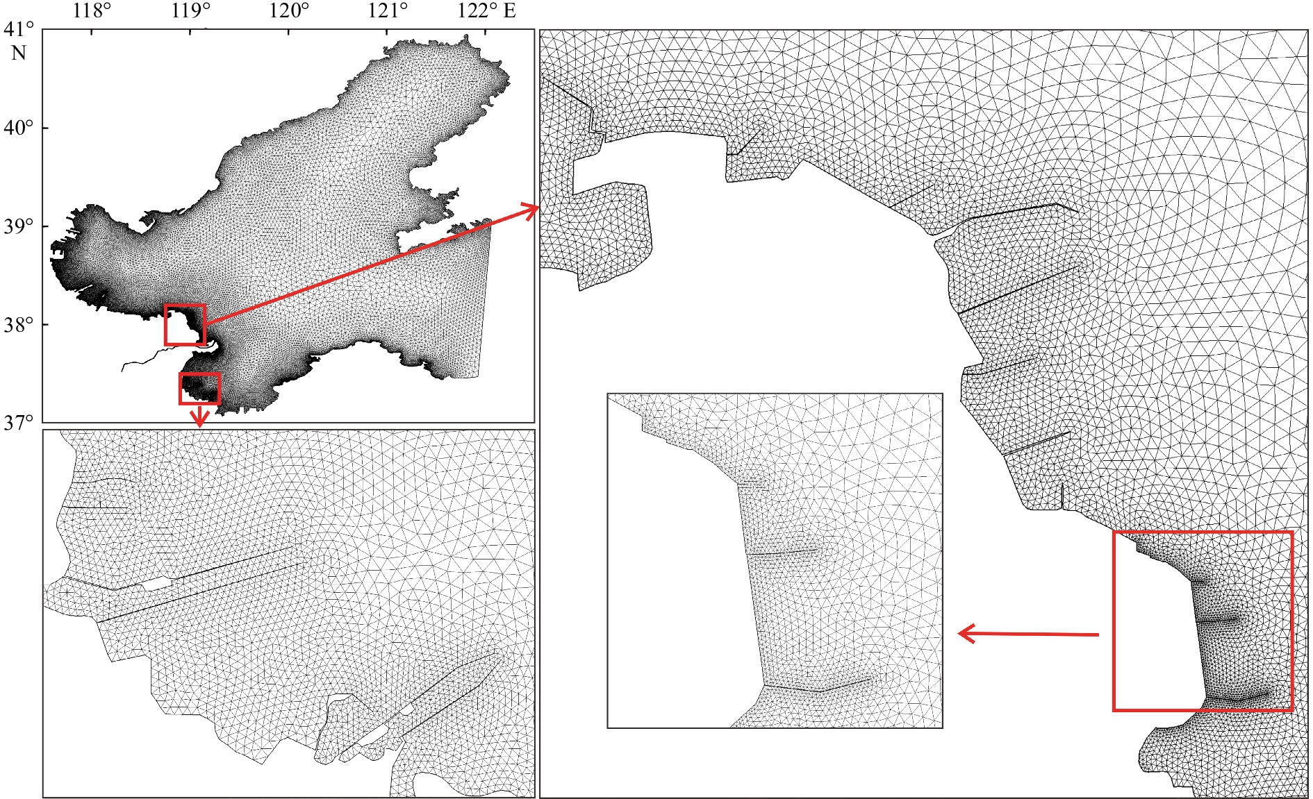
Evolution of tidal system and material transport off the Huanghe River Delta induced by human activities and natural evolution
-
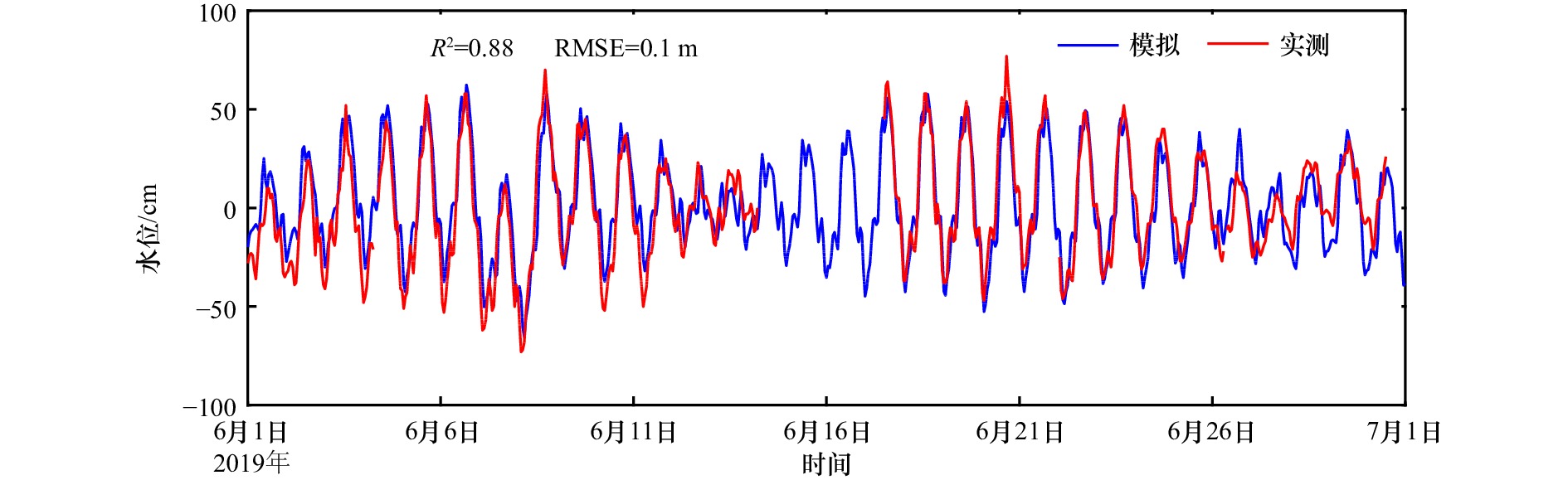
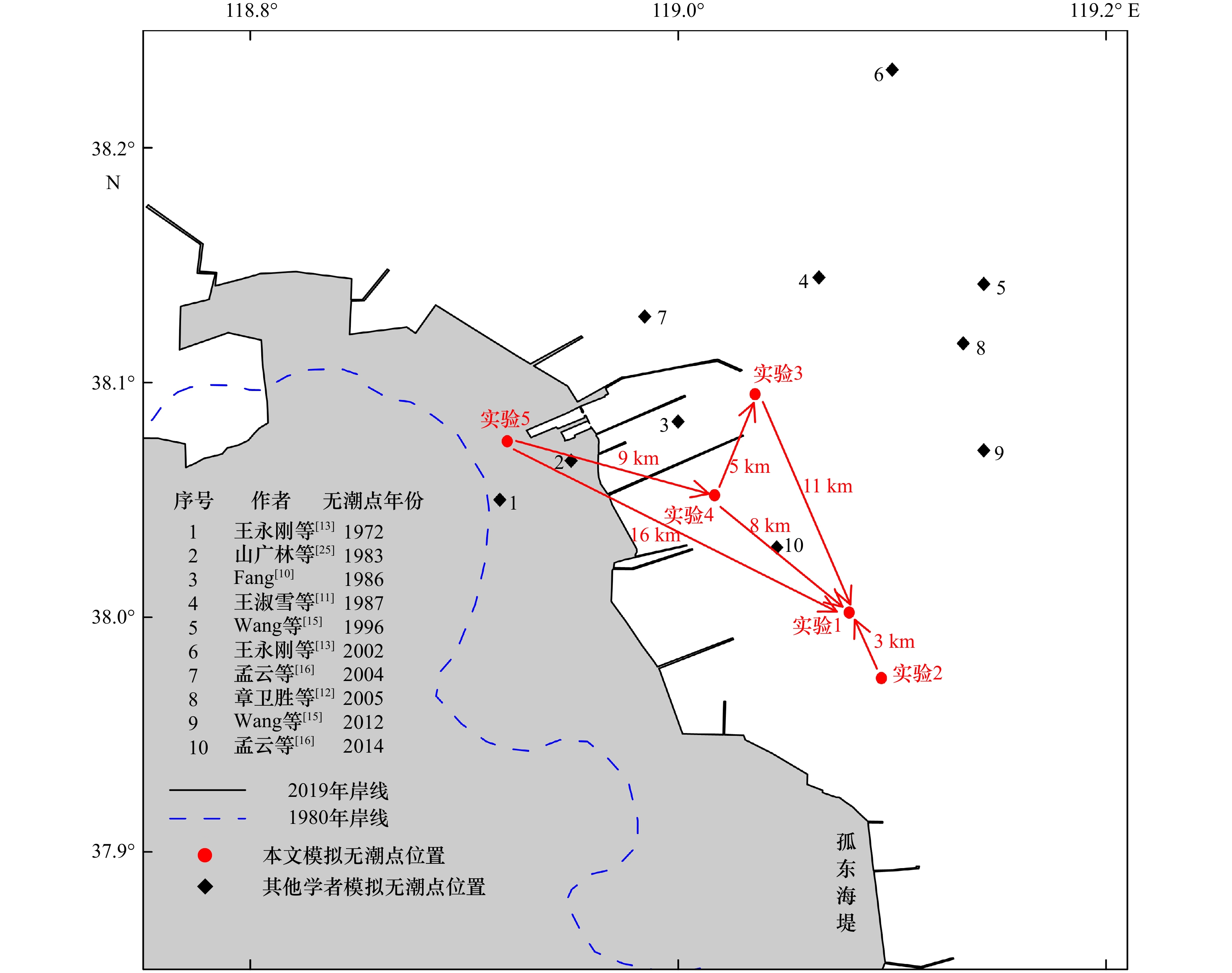
摘要: 在海堤建设等人类活动和三角洲蚀淤等自然演变的共同作用下,黄河三角洲岸线水深近年来发生了剧烈变化,同时也将引起邻近海域潮波系统及物质输运路径的重要变化。本文基于FVCOM数值模式,建立了黄河三角洲及邻近海域三维高分辨率潮汐、潮流及拉格朗日粒子追踪数值模型。通过与环渤海长期验潮站的潮汐调和常数、黄河三角洲临时潮位站和测流站的实测资料对比,模型结果验证良好,能较好反映黄河三角洲及邻近海域潮汐、潮流运动特征,并获得了2019年M2分潮无潮点位置。通过设置1980年、2019年黄河三角洲岸线自然演变、海堤建设及相应水深地形变化的5个数值实验,结果表明:在人类活动与自然演变共同驱动下,黄河三角洲海域的M2分潮无潮点向东南方向移动,主要影响因素为水深。黄河口向海延伸和海堤丁坝建设导致的岸线变化,对无潮点位置影响较小,但在该凸出岸段两侧形成余流流涡,使得黄河入海物质在莱州湾内停留时间变长,向渤海输运扩散的时间推迟。Abstract: In recent years, the topography of Huanghe River Delta exhibits significant changes due to natural and man-made reasons, such as delta acceleration and dyke construction. At the same time, these factors also lead to important variations in the tidal wave system and material transport path in the adjacent sea area. In this study, we establish a three-dimensional high-resolution tide, current and Lagrangian particle tracking numerical model of the Huanghe River Delta and its adjacent sea area based on FVCOM. Our modeling results agree well with the tidal harmonic constant of the tide gauge stations in Bohai Sea region and the observation data of tide level stations and current stations in the Huanghe River Delta. Thus, this model can reflect the characteristics of tide and tidal current in the Huanghe River Delta and its adjacent sea area. Furthermore, the location of the 2019 amphidromic point of M2 is also obtained from this model. By designing five numerical experiments of natural coastline evolution, dyke construction and corresponding water depth changes in the Huanghe River Delta in 1980 and 2019, the following conclusions are drawn. Firstly, from 1980 to 2019, the amphidromic point of M2 moves southeast, with the major factor of water depth. Secondly, changes of coastal line caused by the extension of the Huanghe River Estuary and the construction of dykes have minor effects to the location of amphidromic point of M2. Nevertheless, these changes can form the residual current gyres on both sides of the convex bank. As a result, the material from the Huanghe River stays longer in Laizhou Bay and delays its transportation and diffusion to Bohai Sea.
-
Key words:
- Huanghe River Delta /
- amphidromic point evolution /
- FVCOM /
- material transport
-

图 1 渤海2019年水深地形(a)及黄河三角洲1980–2019年水深变化(b)
Fig. 1 Water depth in the Bohai Sea in 2019 (a) with its variation off the Huanghe River Delta from 1980 to 2019 (b)

图 4 KD站位M2、K1分潮潮流椭圆验证
Fig. 4 Tidal current ellipses validation at KD station for M2 and K1 tidal components
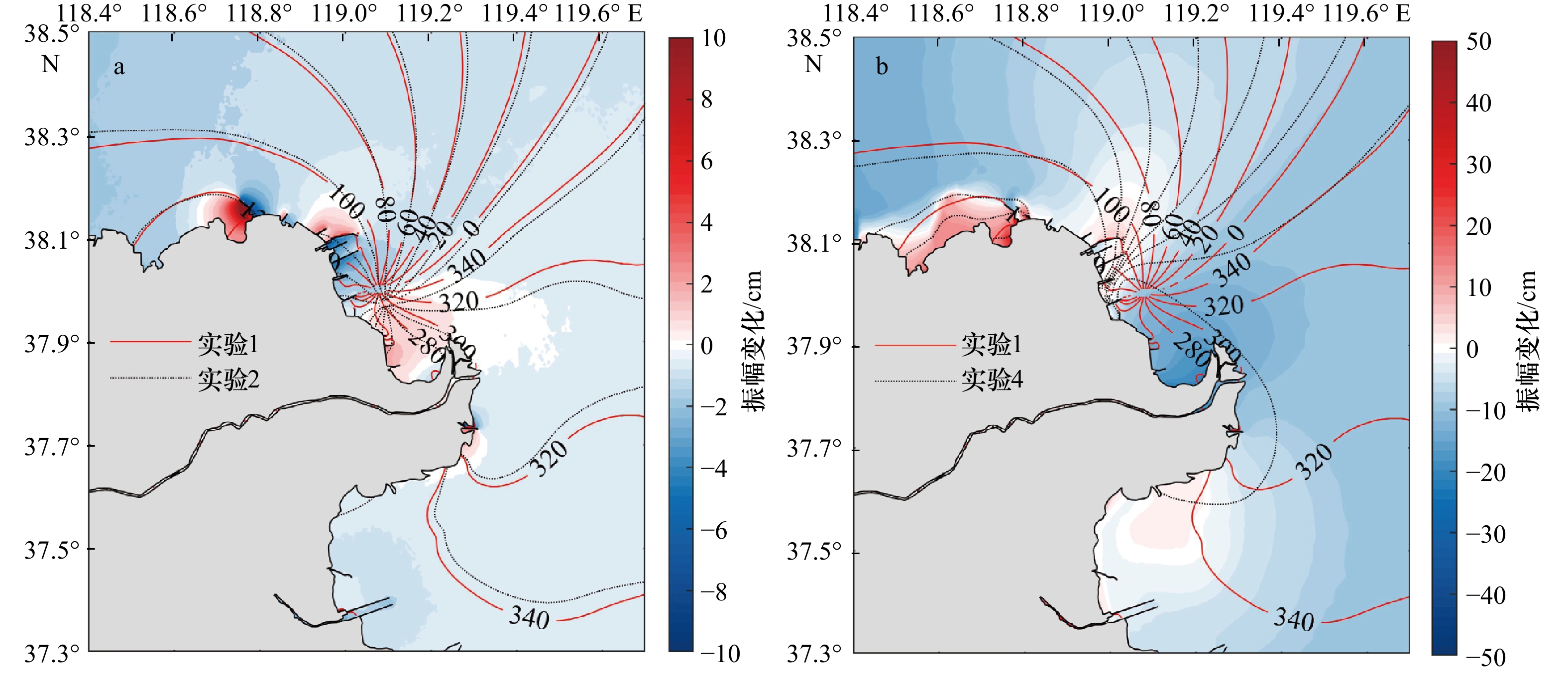
图 7 M2分潮振幅、迟角变化
填色代表振幅变化,等值线代表迟角(单位:(°))变化
Fig. 7 The change of co-amplitude and co-phase lines of the M2 tidal component
Shaded areas indicate the amplitude change and isolines indicate the phase (unit: (°)) change
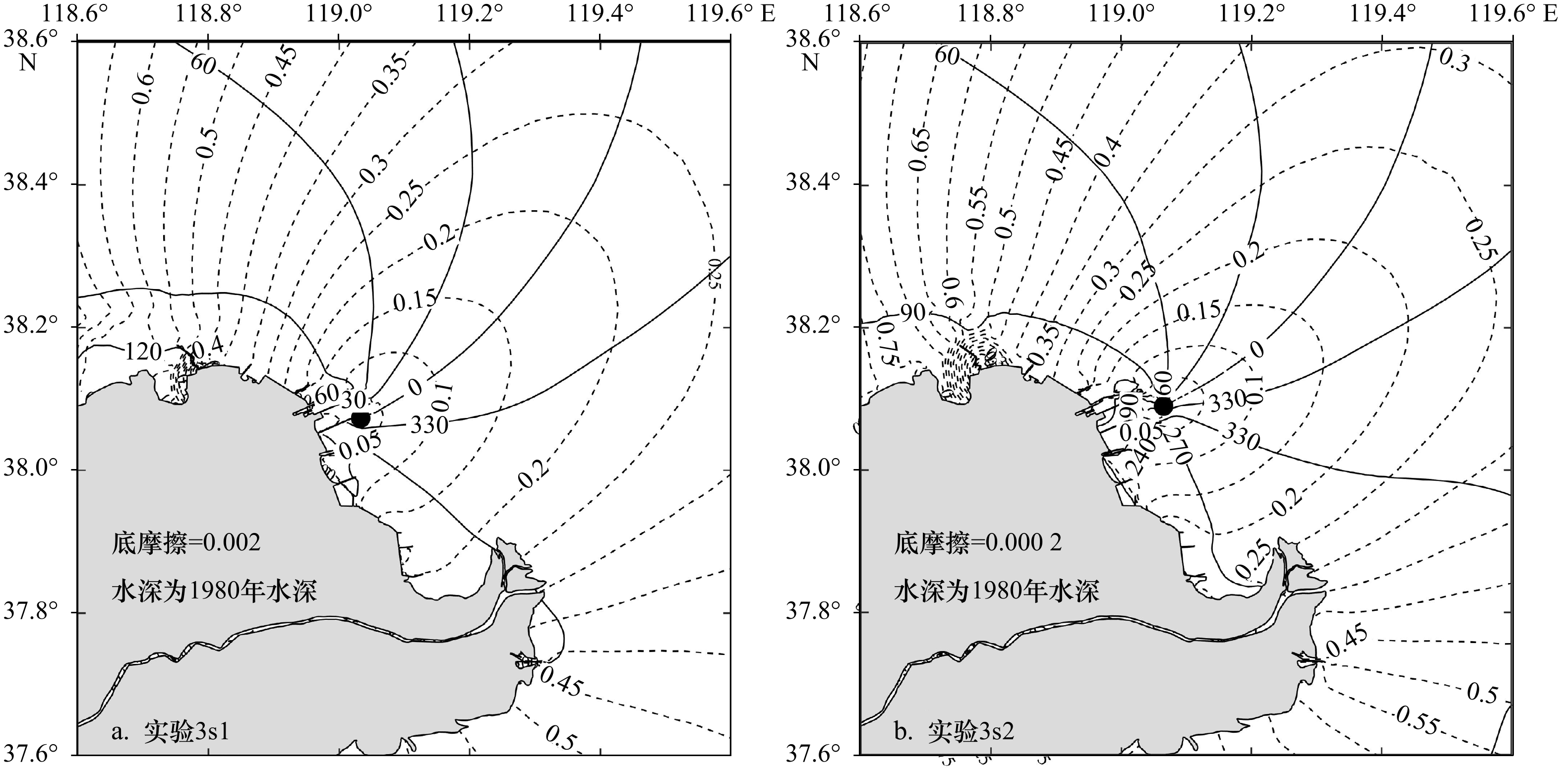
图 8 敏感实验同潮图及无潮点位置
实线表示迟角(单位:(°));虚线表示振幅(单位:m)
Fig. 8 Sensitivity experiment co-tidal diagram and amphidromic points position
The solid lines represent phase (unit: (°)); the dash lines represent amplitude (unit: m)
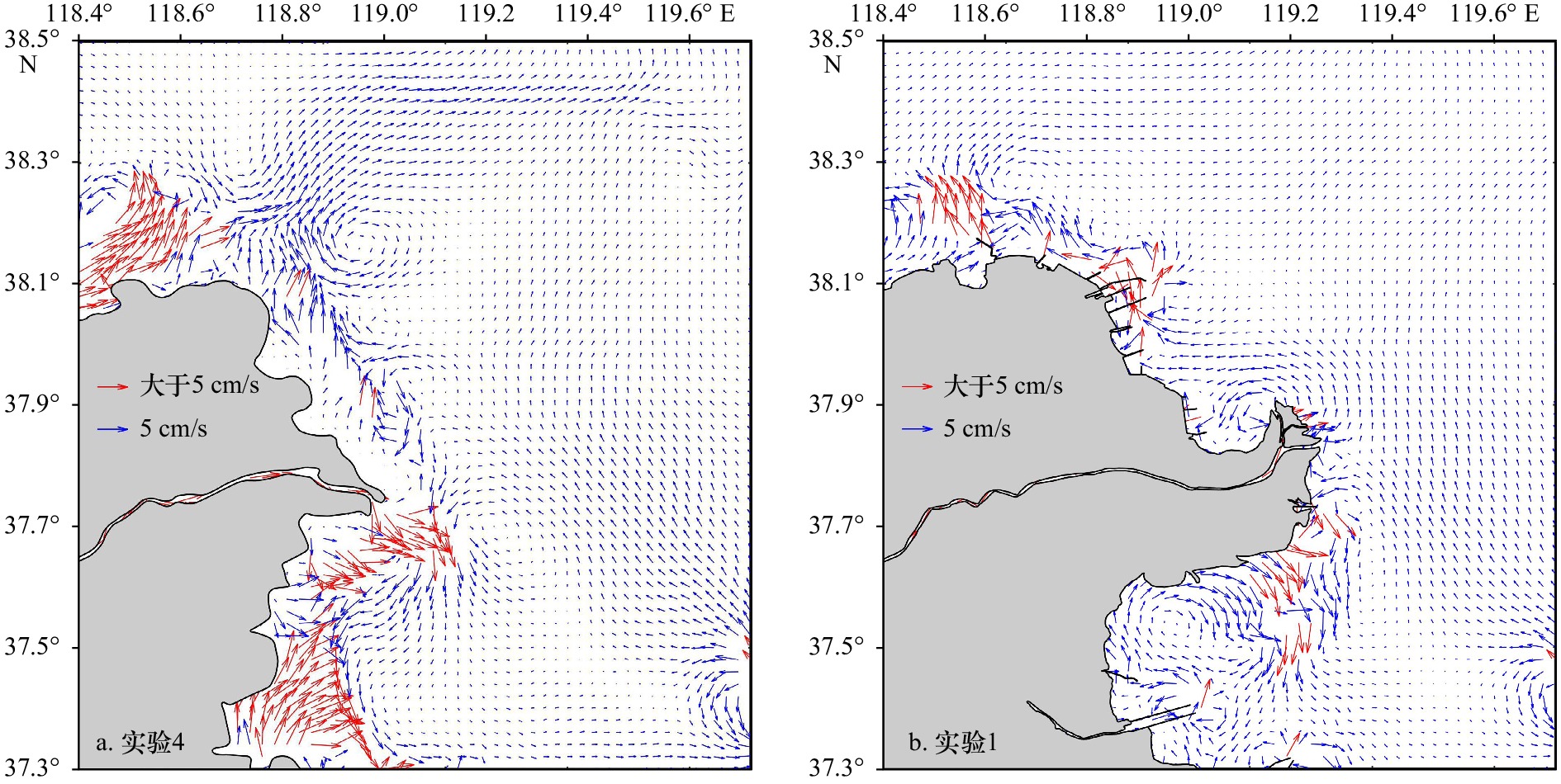
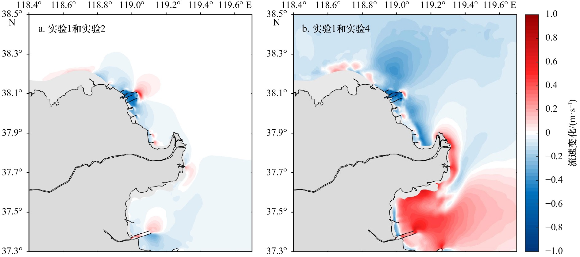
图 10 1980年(a)和2019(b)年表层潮余流场
Fig. 10 Surface tidal residual current field in 1980 (a) and 2019 (b)

图 11 1980年(a)和2019年(b)切变锋特征
线条表示切变锋的锋面,数字表示其在两个潮周期内出现的时间(单位:h)
Fig. 11 Shear front characteristics in 1980 (a) and 2019 (b)
The lines represent the shear fronts, and the numbers represent the time (unit: h) it occurs over two tidal cycles

图 12 1980年(a)和2019年(b)拉格朗日粒子示踪结果
Fig. 12 Lagrangian particle tracer results in 1980 (a) and 2019 (b)

图 13 基于Landsat的 1980年(a)和2019年(b)黄河三角洲表层悬沙遥感影像,丁坝附近海域的表层悬沙分布(c)和涨潮流场(d)
Fig. 13 Landsat images of surface suspended sediment off the Huanghe River Delta in 1980 (a) and 2019 (b), distribution characteristics of surface suspended sediment in the sea in front of the dykes (c), and ebb tidal current around the dyke area (d)
表 1 M2、S2、K1、O1 分潮模拟结果验证
Tab. 1 Model validation for harmonic constants of M2, S2, K1, O1 tidal components
验潮站 M2 S2 O1 K1 振幅
差/cm迟角
差/(°)振幅
差/cm迟角
差/(°)振幅
差/cm迟角
差/(°)振幅
差/cm迟角
差/(°)1 5.59 5.82 0.38 7.26 2.75 10.24 0.91 15.52 2 4.36 0.50 1.03 6.99 0.59 0.27 1.19 3.80 3 0.98 6.45 1.58 0.58 1.61 3.40 0.64 5.68 4 1.75 3.84 2.69 3.33 0.86 1.99 1.11 0.18 5 0.05 5.49 2.67 6.66 0.04 2.10 3.70 2.20 6 5.58 2.74 1.03 8.76 2.25 7.49 3.12 3.19 7 0.56 0.10 1.68 15.86 2.08 3.60 4.86 0.51 8 5.45 3.65 2.17 3.42 0.89 1.26 3.18 10.87 9 3.77 1.80 0.88 11.33 0.01 1.05 1.40 0.02 10 1.45 4.05 0.72 5.88 1.05 0.16 2.36 0.58 11 0.39 3.13 0.28 0.15 2.98 2.19 5.50 2.51 12 1.24 0.67 0.47 1.59 1.61 3.71 2.58 3.06 13 8.06 8.63 1.36 13.36 4.20 2.13 5.78 0.76 14 2.34 4.44 0.83 3.21 0.50 6.54 2.58 4.99 15 4.56 7.42 1.07 6.48 4.31 1.10 5.04 2.83 16 3.23 3.60 0.94 3.97 0.59 6.49 1.62 2.65 17 10.15 0.97 2.60 1.42 0.11 4.85 4.16 3.22 18 9.50 8.00 1.54 4.93 1.61 2.97 0.60 1.29 19 0.58 0.22 0.54 2.47 0.08 2.47 1.26 8.12 20 0.43 4.39 1.05 5.81 0.58 10.90 1.24 9.12 21 6.89 5.43 0.41 10.47 0.91 8.64 1.32 3.97 22 4.82 6.84 1.15 3.40 1.61 8.12 1.96 7.15 孤东 0 4.24 0.01 22.81 0 3.84 0.01 0.35 BH02 0 3.82 0 1.58 0.03 3.97 0.01 1.18 平均绝
对误差3.41 4.01 1.13 6.32 1.30 4.15 2.34 3.91  下载: 导出CSV
表 2 数值实验设置及目的
Tab. 2 Setting and purpose of numerical experiments
实验 水深 岸线 实验目的 1 2019年 2019年 现状水动力(基准模拟) 2 2019年 2019年无丁坝 丁坝的影响 3 1980年 2019年 黄河三角洲岸线
水深变化的影响4 1980年 黄河三角洲1980年岸线,
2019年渤海其余岸线黄河三角洲
岸线水深变化的影响5 1980年 1980年 渤海岸线水深变化的影响
下载: 导出CSV
表 3 孤东验潮站2005和2019年主要分潮调和常数
Tab. 3 Harmonic constants of major components at Gudong tide station in 2005 and 2019
年份 O1分潮 K1分潮 M2分潮 S2分潮 振幅/cm 迟角/(°) 振幅/cm 迟角/(°) 振幅/cm 迟角/(°) 振幅/cm 迟角/(°) 2005年 19 113 23 167 10 291 5 7 2019年 19 104 24 154 3 262 3 337 差值 0 –9 1 –13 –7 –29 –2 –30
下载: 导出CSV
-
[1] 黄海军, 樊辉. 1976年黄河改道以来三角洲近岸区变化遥感监测[J]. 海洋与湖沼, 2004, 35(4): 306−314. doi: 10.3321/j.issn:0029-814X.2004.04.003Huang Haijun, Fan Hui. Monitoring changes of nearshore zones in the Huanghe (Yellow River) Delta since 1976[J]. Oceanologia et Limnologia Sinica, 2004, 35(4): 306−314. doi: 10.3321/j.issn:0029-814X.2004.04.003 [2] Li Guangxue, Yang Zuosheng, Yue Shuhong, et al. Sedimentation in the shear front off the Yellow River Mouth[J]. Continental Shelf Research, 2001, 21(6/7): 607−625. [3] Wang Houjie, Yang Zuosheng, Li Yunhai, et al. Dispersal pattern of suspended sediment in the shear frontal zone off the Huanghe (Yellow River) Mouth[J]. Continental Shelf Research, 2007, 27(6): 854−871. doi: 10.1016/j.csr.2006.12.002 [4] 彭俊, 陈沈良, 李谷祺, 等. 黄河三角洲岸线及现行河口区水下地形演变[J]. 地理学报, 2012, 67(3): 368−376. doi: 10.11821/xb201203008Peng Jun, Chen Shenliang, Li Guqi, et al. Evolution of coastline and subaqueous geomorphology off the survived river mouth in the Yellow River Delta[J]. Acta Geographica Sinica, 2012, 67(3): 368−376. doi: 10.11821/xb201203008 [5] 程慧, 陈沈良, 徐丛亮, 等. 黄河三角洲孤东近岸冲淤演变及其影响因素[J]. 海洋科学, 2019, 43(11): 11−18. doi: 10.11759/hykx20180917001Cheng Hui, Chen Shenliang, Xu Congliang, et al. Coastal evolution and its influencing factors in Gudong near-shore area of the Yellow River Delta[J]. Marine Sciences, 2019, 43(11): 11−18. doi: 10.11759/hykx20180917001 [6] 黄祖珂, 黄磊. 潮汐原理与计算[M]. 青岛: 中国海洋大学出版社, 2005.Huang Zuke, Huang Lei. Tidal Theory and Calculation[M]. Qingdao: China Ocean University Press, 2005. [7] 王志豪. 黄河三角洲风暴潮特征与防潮大堤设计高度[J]. 海洋工程, 1986, 4(1): 71−78.Wang Zhihao. The character of storm and tide of Yellow River Delta and design height of tidal barrier[J]. The Ocean Engineering, 1986, 4(1): 71−78. [8] 陈沈良, 谷国传, 吴桑云. 黄河三角洲风暴潮灾害及其防御对策[J]. 地理与地理信息科学, 2007, 23(3): 100−104, 112. doi: 10.3969/j.issn.1672-0504.2007.03.023Chen Shenliang, Gu Guochuan, Wu Sangyun. Storm surge disasters on the Yellow River Delta and countermeasures[J]. Geography and Geo-Information Science, 2007, 23(3): 100−104, 112. doi: 10.3969/j.issn.1672-0504.2007.03.023 [9] 乐肯堂, 刘兴泉, 史久新. 黄河口的变迁对邻近海区潮波运动影响的数值研究[J]. 海洋科学集刊, 1995(36): 33−46.Le Kentang, Liu Xingquan, Shi Jiuxin. A numerical study on the effect of the changes of the Huanghe River Estuary on the tidal wave movement in its adjacent sea area[J]. Studia Marina Sinica, 1995(36): 33−46. [10] Fang Guohong. Tide and tidal current charts for the marginal seas adjacent to China[J]. Chinese Journal of Oceanology and Limnology, 1986, 4(1): 1−16. doi: 10.1007/BF02850393 [11] 王淑雪, 董以芝, 丁玉兰. 黄河口M2无潮点及潮汐特征分析[J]. 海洋通报, 1987, 6(1): 1−6.Wang Shuxue, Dong Yizhi, Ding Yulan. Analysis of amphidromic point M2 and the tidal characteristics at Huanghe River Mouth[J]. Marine Science Bulletin, 1987, 6(1): 1−6. [12] 章卫胜, 张金善, 林瑞栋, 等. 中国近海潮汐变化对外海海平面上升的响应[J]. 水科学进展, 2013, 24(2): 243−250.Zhang Weisheng, Zhang Jinshan, Lin Ruidong, et al. Tidal response of sea level rise in marginal seas near China[J]. Advances in Water Science, 2013, 24(2): 243−250. [13] 王永刚, 魏泽勋, 方国洪, 等. 黄河口及其邻近海域水深和岸线变化对M2分潮影响的数值研究[J]. 海洋科学进展, 2014, 32(2): 141−147. doi: 10.3969/j.issn.1671-6647.2014.02.003Wang Yonggang, Wei Zexun, Fang Guohong, et al. A numerical study on the effect of changes in water depth and coastline on M2 tidal component near the Yellow River Estuary[J]. Advances in Marine Science, 2014, 32(2): 141−147. doi: 10.3969/j.issn.1671-6647.2014.02.003 [14] 李秉天, 王永刚, 魏泽勋, 等. 渤海主要分潮的模拟及地形演变对潮波影响的数值研究[J]. 海洋与湖沼, 2015, 46(1): 9−16.Li Bingtian, Wang Yonggang, Wei Zexun, et al. Numerical study on tides of Bohai Sea and impact of topography changes on the tidal wave system[J]. Oceanologia et Limnologia Sinica, 2015, 46(1): 9−16. [15] Wang Nan, Li Guangxue, Xu Jishang, et al. The marine dynamics and changing trend off the modern Yellow River Mouth[J]. Journal of Ocean University of China, 2015, 14(3): 433−445. doi: 10.1007/s11802-015-2764-0 [16] 孟云, 娄安刚, 刘亚飞, 等. 渤海岸线地形变化对潮波系统和潮流性质的影响[J]. 中国海洋大学学报, 2015, 45(12): 1−7, 101.Meng Yun, Lou An’gang, Liu Yafei, et al. Impact of coastline and topography changes on tidal wave system and tidal current character in the Bohai Sea[J]. Periodical of Ocean University of China, 2015, 45(12): 1−7, 101. [17] 董娇娇, 孙健, 陈燕珍, 等. 渤海岸线及水深变化对水动力影响的数值模拟[J]. 海洋科学进展, 2020, 38(4): 676−687. doi: 10.3969/j.issn.1671-6647.2020.04.011Dong Jiaojiao, Sun Jian, Chen Yanzhen, et al. Numerical simulation of the hydrodynamics affected by coastline and bathymetry changes in the Bohai Sea[J]. Advances in Marine Science, 2020, 38(4): 676−687. doi: 10.3969/j.issn.1671-6647.2020.04.011 [18] Zhu Longhai, Hu Rijun, Zhu Haijun, et al. Modeling studies of tidal dynamics and the associated responses to coastline changes in the Bohai Sea, China[J]. Ocean Dynamics, 2018, 68(12): 1625−1648. doi: 10.1007/s10236-018-1212-2 [19] Chen Changsheng, Beardsley R C, Cowles G. An unstructured grid, finite-volume coastal ocean model (FVCOM) system[J]. Oceanography, 2006, 19(1): 78−89. doi: 10.5670/oceanog.2006.92 [20] 丁芮, 陈学恩, 曲念东. 珠江口及邻近海域潮波数值模拟——Ⅰ模型的建立和分析[J]. 中国海洋大学学报, 2015, 45(11): 1−9.Ding Rui, Chen Xueen, Qu Niandong. Three-dimensional high-resolution numerical study of the tide and circulation in the Pearl River Estuary and its adjacent waters Part I: model building and analysis[J]. Periodical of Ocean University of China, 2015, 45(11): 1−9. [21] 李春良, 倪晓雯, 梅国永. FVCOM在长江口水动力数值模拟中的应用[J]. 港工技术, 2016, 53(3): 1−5.Li Chunliang, Ni Xiaowen, Mei Guoyong. Application of FVCOM in numerical simulation of hydrodynamic force at Yangtze River Estuary[J]. Port Engineering Technology, 2016, 53(3): 1−5. [22] Zhong Yi, Qiao Lulu, Song Dehai, et al. Impact of cold water mass on suspended sediment transport in the South Yellow Sea[J]. Marine Geology, 2020, 428: 106244. doi: 10.1016/j.margeo.2020.106244 [23] 韩沙沙, 谈广鸣, 赵连军, 等. 黄河入海水沙情势变化分析[J]. 中国农村水利水电, 2022(2): 1−5, 19. doi: 10.3969/j.issn.1007-2284.2022.02.001Han Shasha, Tan Guangming, Zhao Lianjun, et al. An analysis of the latest variations of incoming water and sediment in the Yellow River Delta[J]. China Rural Water and Hydropower, 2022(2): 1−5, 19. doi: 10.3969/j.issn.1007-2284.2022.02.001 [24] 王柯萌, 孙永福, 宋玉鹏, 等. 调水调沙对黄河三角洲切变锋及冲淡水扩散的影响[J]. 海洋科学进展, 2019, 37(4): 551−564.Wang Kemeng, Sun Yongfu, Song Yupeng, et al. Characteristics of shear fronts and dispersal of diluted water during the water-sediment regulation scheme in Yellow River Delta[J]. Advances in Marine Science, 2019, 37(4): 551−564. [25] 山广林, 刘赞沛, 王钟桾, 等. 渤海潮混合数值模拟 Ⅰ.渤海主要半日分潮的数值模拟[J]. 海洋与湖沼, 1983, 14(5): 419−431.Shan Guanglin, Liu Zanpei, Wang Zhongjin, et al. Numerical simulation of the tidal mixing in the Bohai Sea Ⅰ.the Numerical simulation of the principal semidiurnal constituent in the Bohai Sea[J]. Oceanologia et Limnologia Sinica, 1983, 14(5): 419−431. [26] Qiao L L, Bao X W, Wu D X, et al. Numerical study of generation of the tidal shear front off the Yellow River Mouth[J]. Continental Shelf Research, 2008, 28(14): 1782−1790. doi: 10.1016/j.csr.2008.04.007 [27] 王厚杰, 杨作升, 毕乃双. 黄河口泥沙输运三维数值模拟Ⅰ——黄河口切变锋[J]. 泥沙研究, 2006(2): 1−9. doi: 10.3321/j.issn:0468-155X.2006.02.001Wang Houjie, Yang Zuosheng, Bi Naishuang. 3-D simulation of the suspended sediment transport in the Yellow River Mouth Ⅰ: shear front off the Yellow River mouth[J]. Journal of Sediment Research, 2006(2): 1−9. doi: 10.3321/j.issn:0468-155X.2006.02.001 [28] Wang Nan, Li Guangxue, Qiao Lulu, et al. Long-term evolution in the location, propagation, and magnitude of the tidal shear front off the Yellow River Mouth[J]. Continental Shelf Research, 2017, 137: 1−12. doi: 10.1016/j.csr.2017.01.020 [29] Ji Hongyu, Pan Shunqi, Chen Shenliang. Impact of river discharge on hydrodynamics and sedimentary processes at Yellow River Delta[J]. Marine Geology, 2020, 425: 106210. doi: 10.1016/j.margeo.2020.106210 -


计量
- 文章访问数: 822
- HTML全文浏览量: 294
- PDF下载量: 113
- 被引次数: 0
