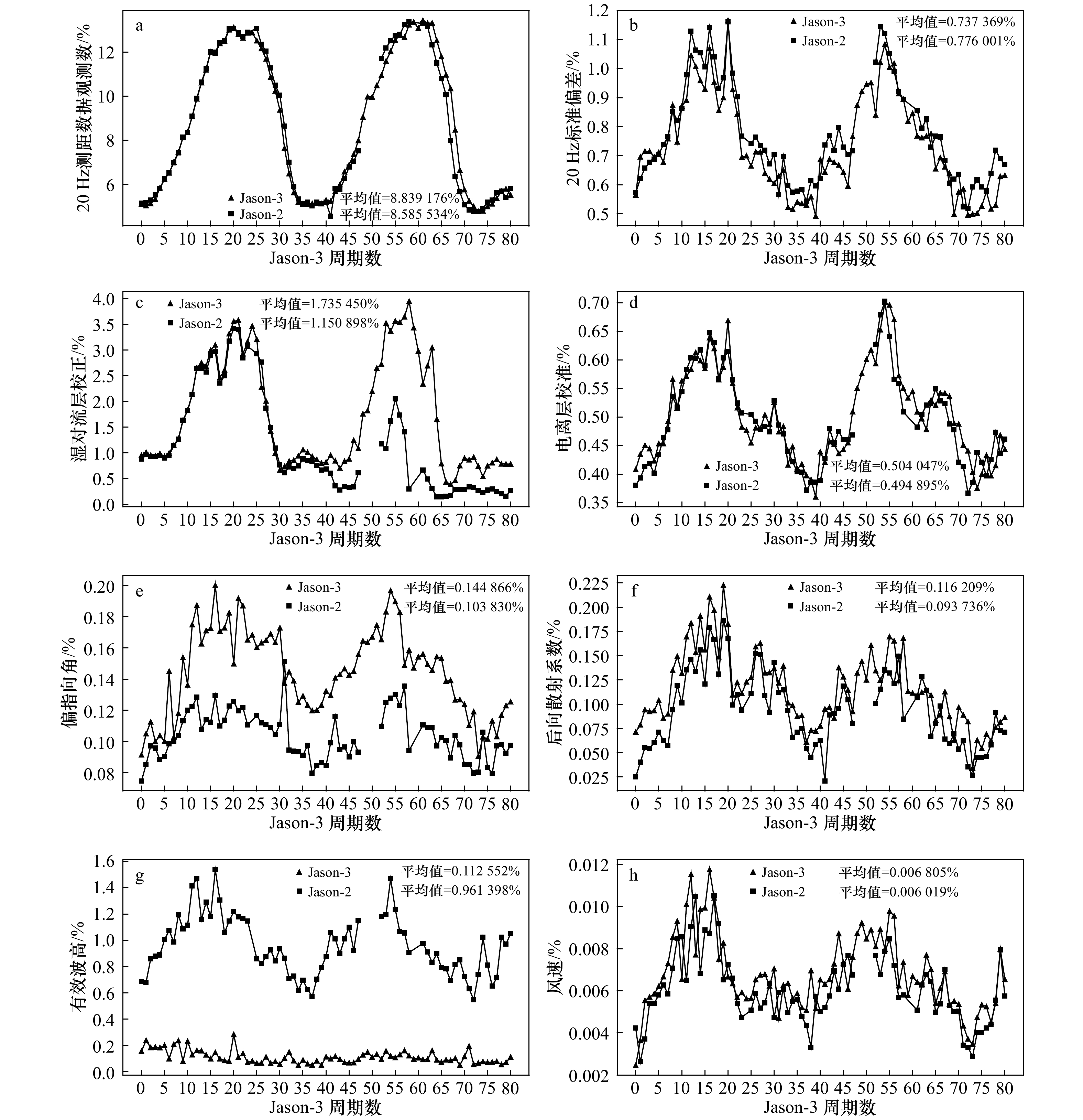
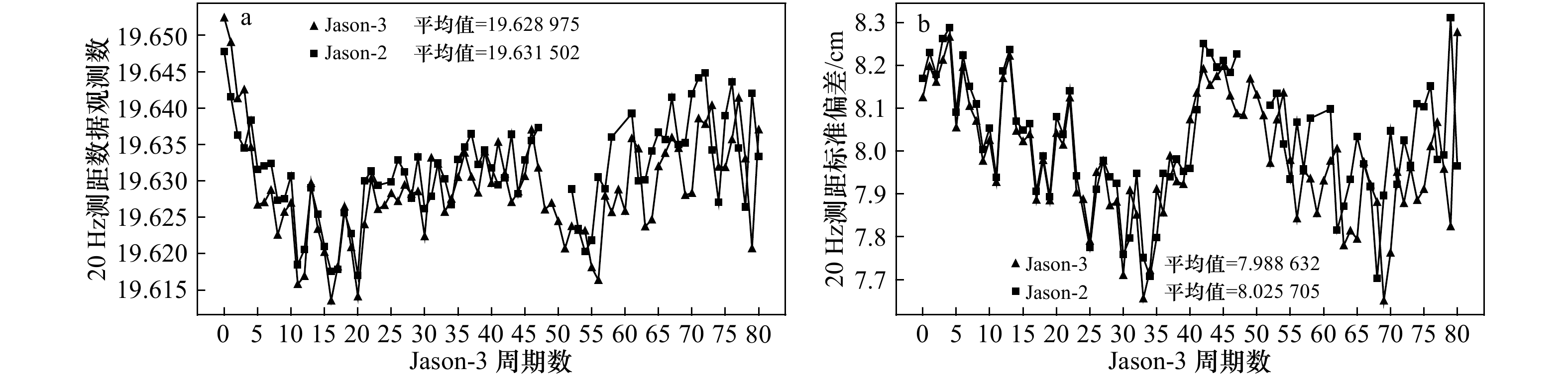
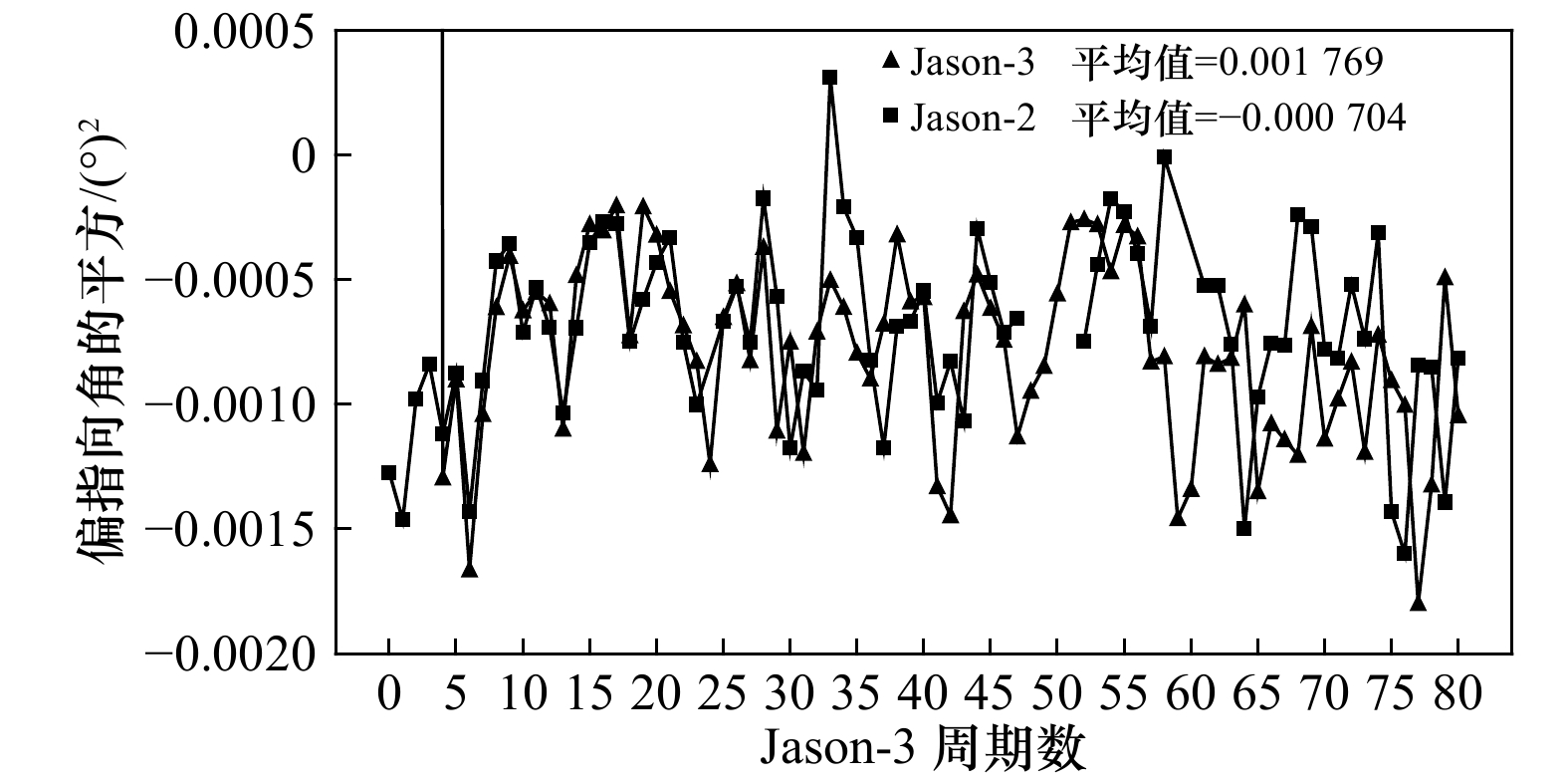
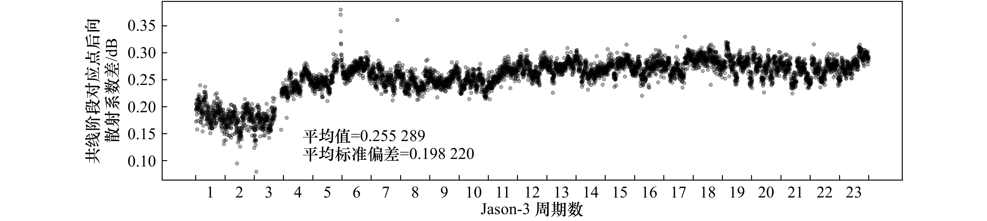
| Citation: | Liu Zhizhong,Yang Jungang,Zhang Jie, et al. Jason-3 global statistical assessment based on Jason-2[J]. Haiyang Xuebao,2020, 42(3):129–139,doi:10.3969/j.issn.0253−4193.2020.03.012

|

| [1] |
崔伟, 王伟, 马毅, 等. 基于1993–2014年高度计数据的西北太平洋中尺度涡识别和特征分析[J]. 海洋学报, 2017, 39(2): 16−28.
Cui Wei, Wang Wei, Ma Yi, et al. Identification and analysis of mesoscale eddies in the Northwestern Pacific Ocean from 1993-2014 based on altimetry data[J]. Haiyang Xuebao, 2017, 39(2): 16−28.
|
| [2] |
胡冬, 陈希, 毛科峰, 等. 黑潮延伸体邻近区域中尺度涡特征统计分析[J]. 海洋与湖沼, 2018, 49(3): 497−511.
Hu Dong, Chen Xi, Mao Kefeng, et al. Statistical characteristics of mesoscale eddies near the kuroshio extension region[J]. Ocean and Lakes, 2018, 49(3): 497−511.
|
| [3] |
赵杰, 汪一航, 王永刚, 等. 基于卫星高度计资料提取浙江近海的潮汐信息[J]. 应用海洋学学报, 2018, 37(3): 356−365. doi: 10.3969/J.ISSN.2095-4972.2018.03.007
Zhao Jie, Wang Yihang, Wang Yonggang, et al. Extraction of tidal information on Zhejiang offshore based on satellite altimetry data[J]. Journal of Applied Oceanography, 2018, 37(3): 356−365. doi: 10.3969/J.ISSN.2095-4972.2018.03.007
|
| [4] |
王天驹, 齐琳琳, 朱江, 等. HY-2卫星高度计波高资料在集合最优插值同化中的应用研究——以台风“Lipee”为例[J]. 海洋学报, 2017, 39(2): 29−38.
Wang Tianju, Qi Linlin, Zhu Jiang, et al. Application studies of using HY-2 satellite altimeter wave data in ensemble optimal interpolation method——"Lipee" for instance[J]. Haiyang Xuebao, 2017, 39(2): 29−38.
|
| [5] |
贾永君, 林明森, 张有广. 海洋二号卫星A星雷达高度计在海洋防灾减灾中的应用[J]. 卫星应用, 2018(5): 34−39. doi: 10.3969/j.issn.1674-9030.2018.05.010
Jia Yongjun, Lin Mingsen, Zhang Youguang. Application of ocean altimeter a satellite radar altimeter in marine disaster prevention and mitigation[J]. Satellite Applications, 2018(5): 34−39. doi: 10.3969/j.issn.1674-9030.2018.05.010
|
| [6] |
赵小阳, 李建成, 王正涛, 等. 利用卫星测高技术监测厄尔尼诺和拉尼娜现象[J]. 海洋测绘, 2007, 27(1): 41−44. doi: 10.3969/j.issn.1671-3044.2007.01.011
Zhao Xiaoyang, Li Jiancheng, Wang Zhengtao, et al. Using satellite altimetry technique for monitoring El Niño and La Nña phenomenon[J]. Marine Surveying and Mapping, 2007, 27(1): 41−44. doi: 10.3969/j.issn.1671-3044.2007.01.011
|
| [7] |
杨磊, 周兴华, 彭海龙, 等. 基于Jason-2的Saral/AltiKa高度计全球统计评估与交叉定标[J]. 海洋科学进展, 2014, 32(4): 482−490. doi: 10.3969/j.issn.1671-6647.2014.04.005
Yang Lei, Zhou Xinghua, Peng Hailong, et al. Global assessment and cross-calibration of Saral/AltiKa based on Jason-2 altimeter[J]. Advances in Marine Science, 2014, 32(4): 482−490. doi: 10.3969/j.issn.1671-6647.2014.04.005
|
| [8] |
Prandi P, Philipps S, Pignot V, et al. SARAL/AltiKa global statistical assessment and cross-calibration with jason-2[J]. Marine Geodesy, 2015, 38(S1): 297−312.
|
| [9] |
Chambers D P, Ries J C, Urban T J. Calibration and verification of jason-1 using global along-track residuals with TOPEX special issue: jason-1 calibration/validation[J]. Marine Geodesy, 2003, 26(3/4): 305−317. doi: 10.1080/714044523
|
| [10] |
彭海龙, 林明森, 穆博, 等. HY-2A卫星雷达高度计数据的全球统计评价及质量分析[J]. 海洋学报, 2015, 37(7): 54−66.
Peng Hailong, Lin Mingsen, Mu Bo, et al. Global statistical evaluation and performance analysis of HY-2A satellite radar altimeter data[J]. Haiyang Xuebao, 2015, 37(7): 54−66.
|
| [11] |
Dorandeu J, Ablain M, Faugère Y, et al. Jason-1 global statistical evaluation and performance assessment: Calibration and cross-calibration results[J]. Marine Geodesy, 2004, 27(3/4): 345−372. doi: 10.1080/01490410490889094
|
| [12] |
Ablain M, Philipps S, Picot N, et al. Jason-2 global statistical assessment and cross-calibration with Jason-1[J]. Marine Geodesy, 2010, 33(S1): 162−185. doi: 10.1080/01490419.2010.487805
|
| [13] |
翟国君, 黄漠涛, 谢锡君, 等. 卫星测高数据处理的理论与方法[M]. 北京: 测绘出版社, 2000.
Zhai Guojun, Huang Motao, Xie Xijun, et al. Theories and Methods of Satellite Altimetry Data Processing[M]. Beijing: Surveying and Mapping Press, 2000.
|
| [14] |
汪海洪, 罗北. 计算测高卫星地面轨迹交叉点的快速数值算法[J]. 武汉大学学报: 信息科学版, 2017, 42(3): 293−298.
Wang Haihong, Luo Bei. Fast numerical algorithm for the calculation of altimetric crossovers from satellite ground tracks[J]. Geomatics and Information Science of Wuhan University, 2017, 42(3): 293−298.
|
| [15] |
Wessel P. Tools for analyzing intersecting tracks: The x2sys package[J]. Computers & Geosciences, 2010, 36(3): 348−354.
|
| [16] |
Desjonquères J D, Carayon G, Steunou N, et al. Poseidon-3 radar altimeter: new modes and in-flight performances[J]. Marine Geodesy, 2010, 33(S1): 53−79. doi: 10.1080/01490419.2010.488970
|
| [17] |
崔伟. 多源卫星高度计海面高度异常数据融合研究[D]. 青岛: 国家海洋局第一海洋研究所, 2016.
Cui Wei. The study of merging sea level anomalies data derived from multi-satellite altimeter[D]. Qingdao: First Institute of Oceanography, State Oceanic Administration, 2016.
|

Figures(18) / Tables(1)


 DownLoad: