


2021 Vol. 43, No. 6
Display Method:
Hydrography and circulation of the South China Sea in deep summer: The August 2000 cruises revisited
2021, 43(6): 1-12.
doi: 10.12284/hyxb2021088
Abstract:
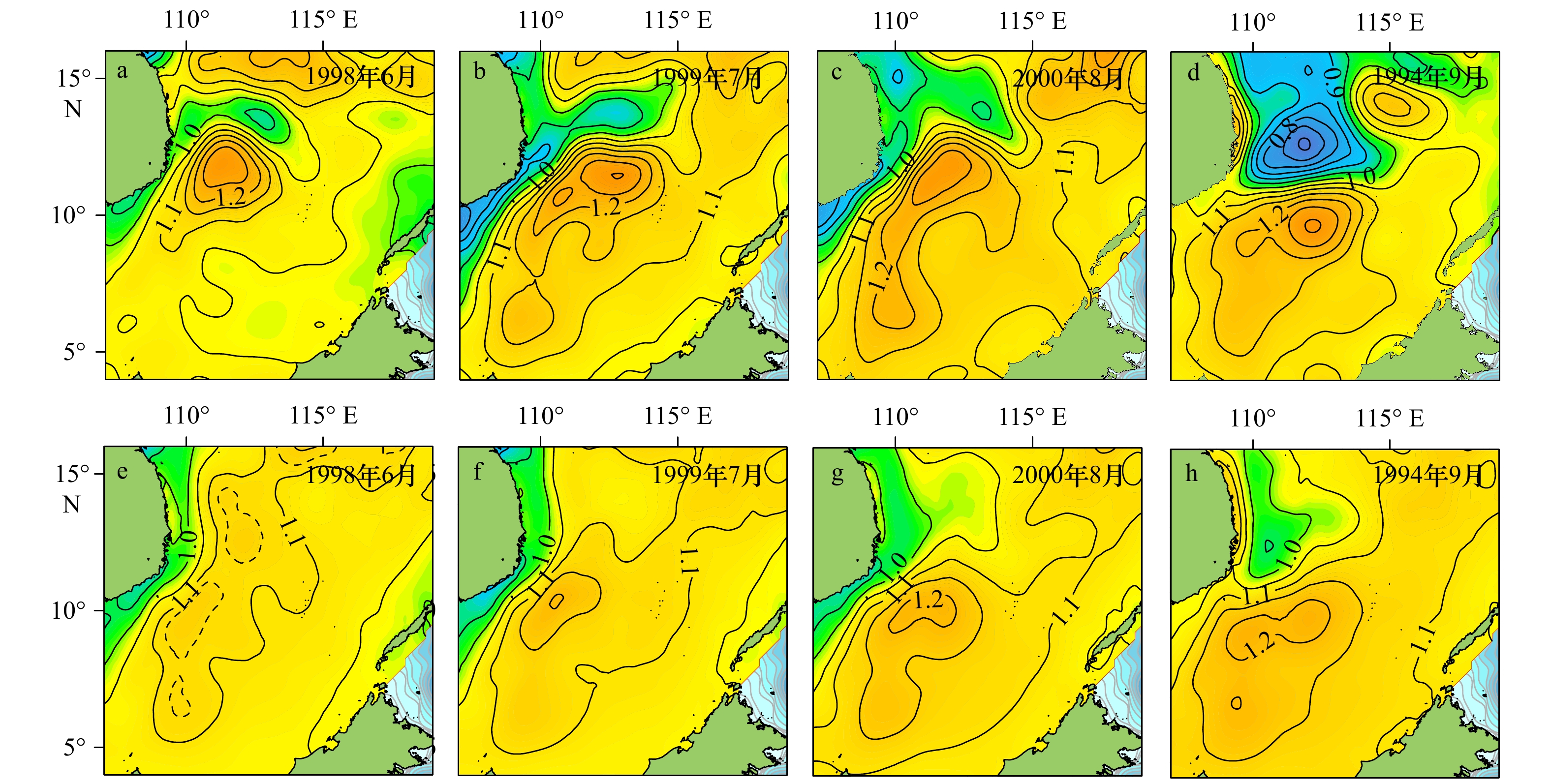
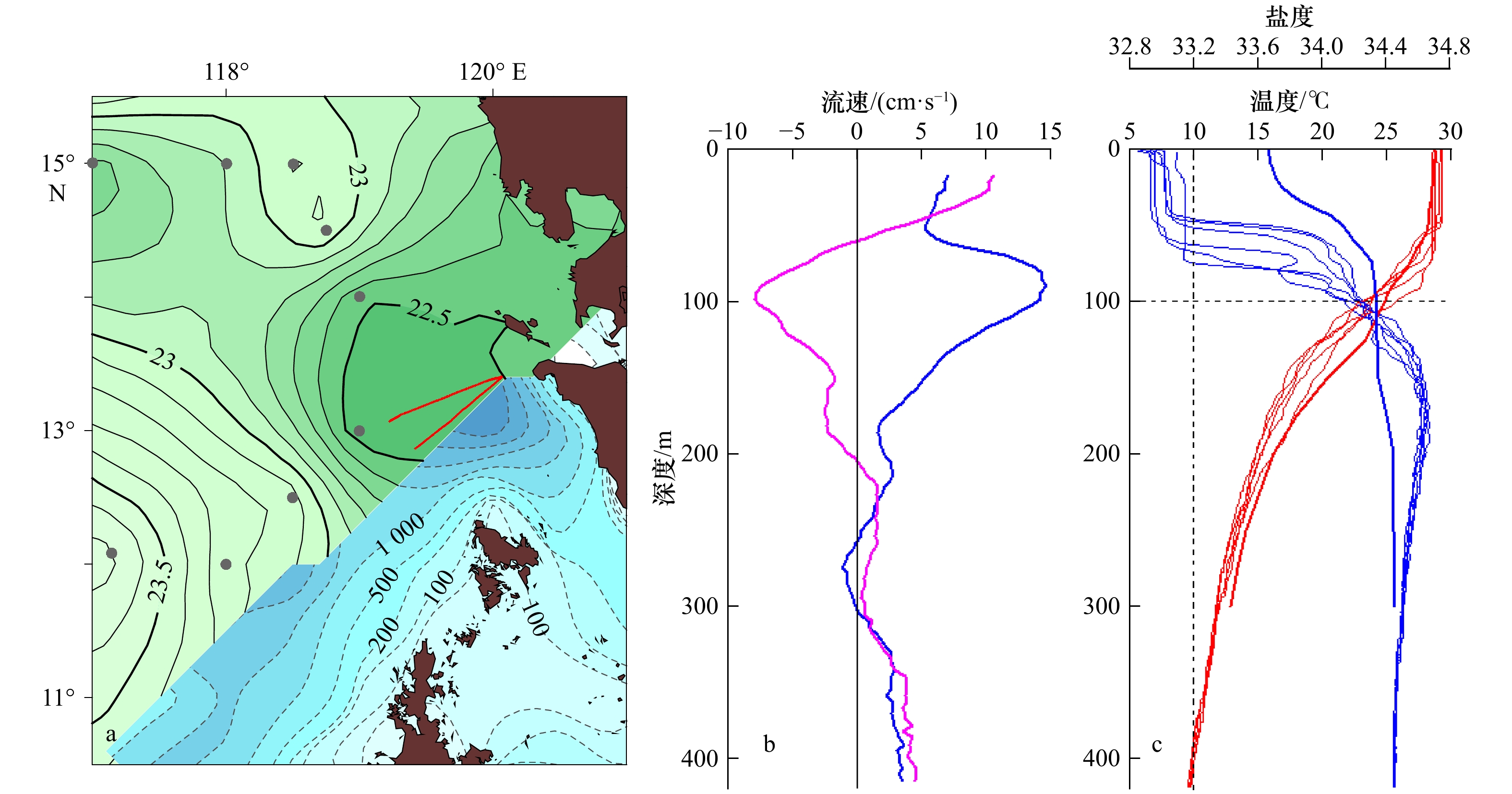
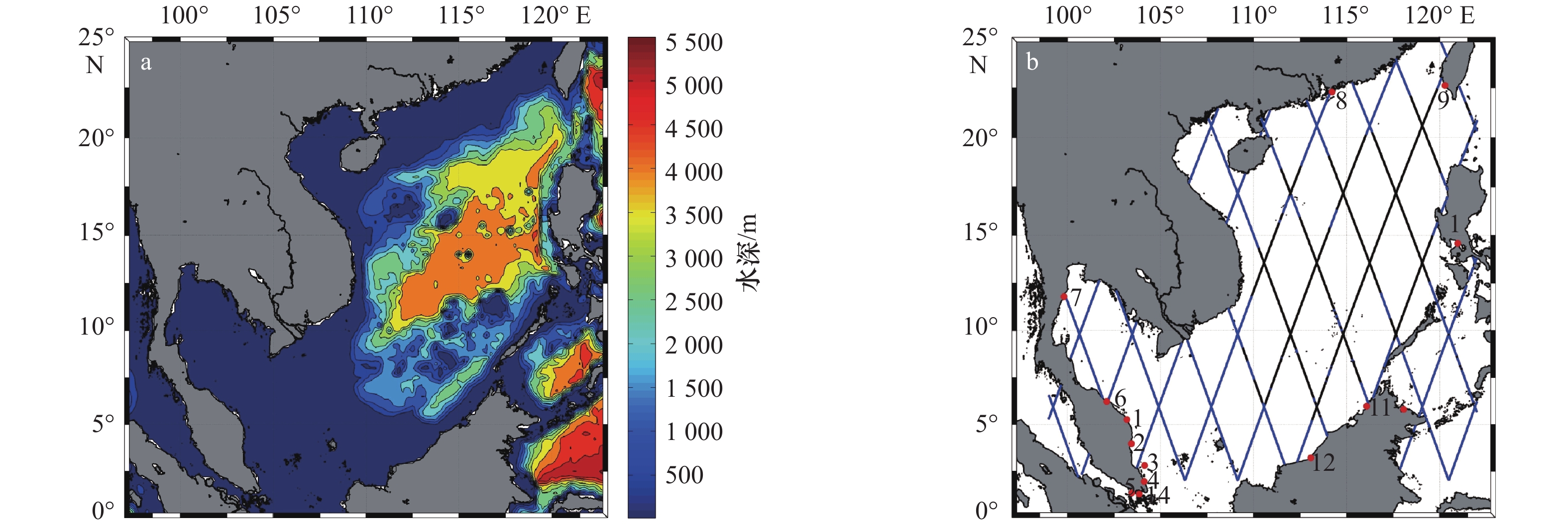
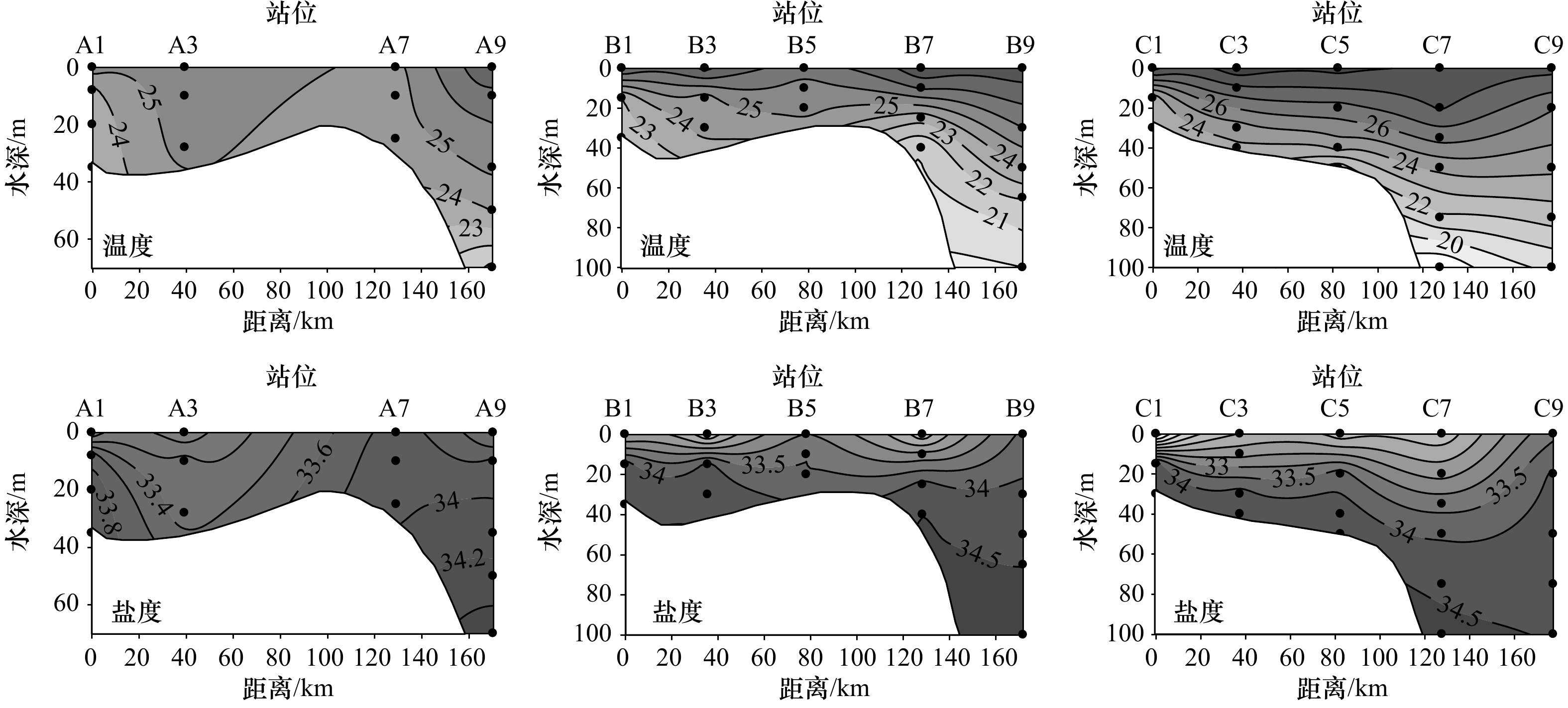
Funded by the National Key Basic Research Development Program, a multi-vessel oceanography survey was conducted synoptically in the South China Sea (SCS) in August 2000, which appeared to be the unique, available synoptic survey that covered the entire SCS basin in deep summer. A number of difficulties were encountered during the survey that affected the quality of observation, even though they were resolved underway. Although some related research works were previously published, no carefully quality control of the data and a comprehensive analyses had ever appeared before. In this work, the original CTD and shipboard ADCP data were carefully calibrated in the first place, and the hydrography and circulation features were then analyzed and discussed to leave a record of the cruises as complete as possible. The results indicate that, in deep summer, the basin shows different physical characteristics on both sides of its SW–NE oriented axis of the basin. The circulation is generally anticyclonic southeast of the axis, in which the Nansha anticyclonic gyre (NSAG) is especially powerful; the area northwest of the axis, in contrast, appears to be dominated by mesoscale features of different categories, where no obvious structure of large scale circulation is found. The analyses confirm that the scales of the NSAG are over 400 km horizontally and nearly 1000 m vertically, with a maximal swirling speed close to 1 m/s, which appears to be the most remarkable circulation feature of the SCS. Moreover, its position and strength are subject to significant interannual variation. In the Mindoro Strait, the exchange flow showes a sandwich structure during the observation period. This is different from our previous understanding and suggests that the strait exchange may have different modes varying with the forcing condition.
Funded by the National Key Basic Research Development Program, a multi-vessel oceanography survey was conducted synoptically in the South China Sea (SCS) in August 2000, which appeared to be the unique, available synoptic survey that covered the entire SCS basin in deep summer. A number of difficulties were encountered during the survey that affected the quality of observation, even though they were resolved underway. Although some related research works were previously published, no carefully quality control of the data and a comprehensive analyses had ever appeared before. In this work, the original CTD and shipboard ADCP data were carefully calibrated in the first place, and the hydrography and circulation features were then analyzed and discussed to leave a record of the cruises as complete as possible. The results indicate that, in deep summer, the basin shows different physical characteristics on both sides of its SW–NE oriented axis of the basin. The circulation is generally anticyclonic southeast of the axis, in which the Nansha anticyclonic gyre (NSAG) is especially powerful; the area northwest of the axis, in contrast, appears to be dominated by mesoscale features of different categories, where no obvious structure of large scale circulation is found. The analyses confirm that the scales of the NSAG are over 400 km horizontally and nearly 1000 m vertically, with a maximal swirling speed close to 1 m/s, which appears to be the most remarkable circulation feature of the SCS. Moreover, its position and strength are subject to significant interannual variation. In the Mindoro Strait, the exchange flow showes a sandwich structure during the observation period. This is different from our previous understanding and suggests that the strait exchange may have different modes varying with the forcing condition.


2021, 43(6): 13-25.
doi: 10.12284/hyxb2021094
Abstract:
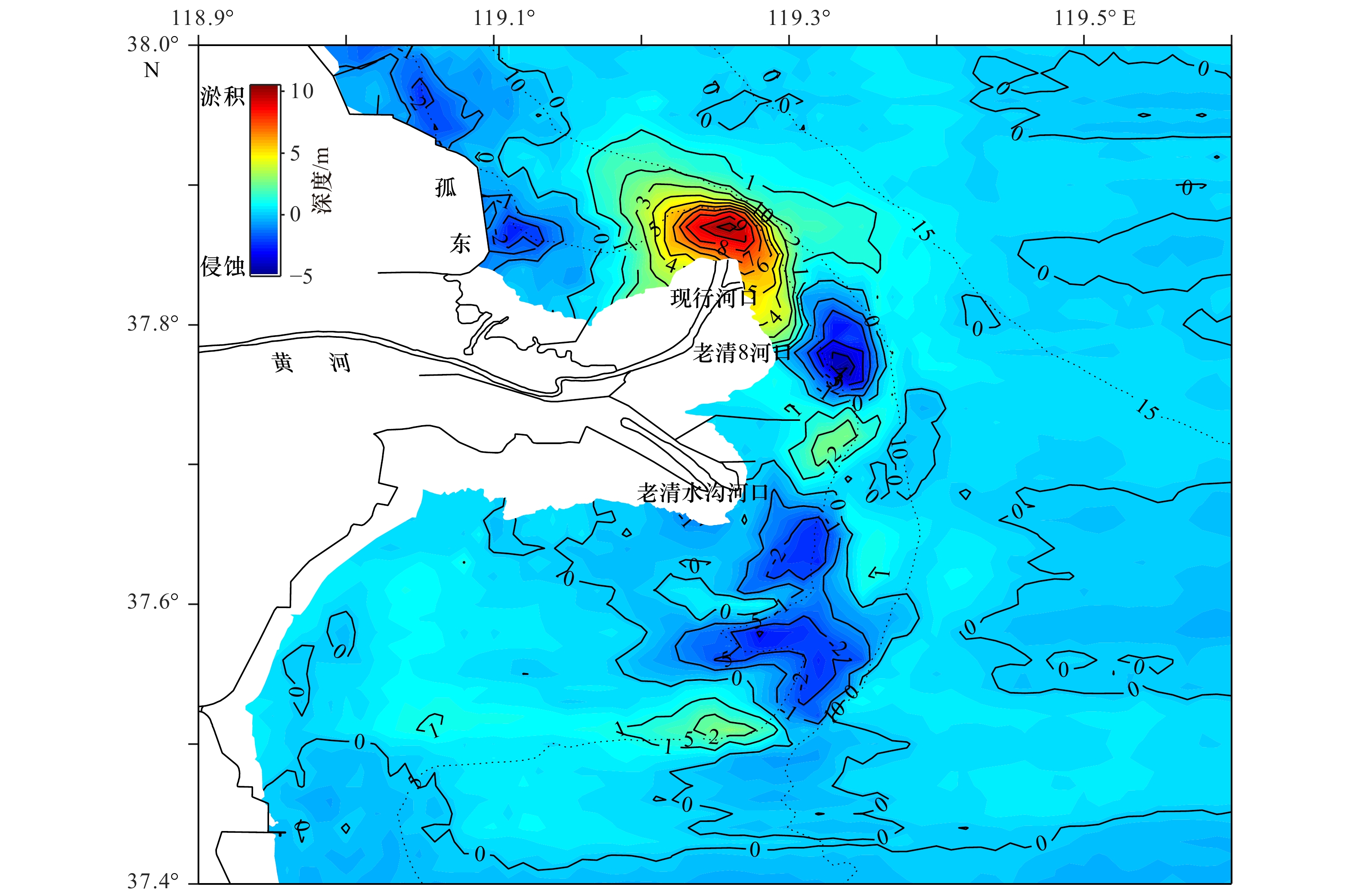
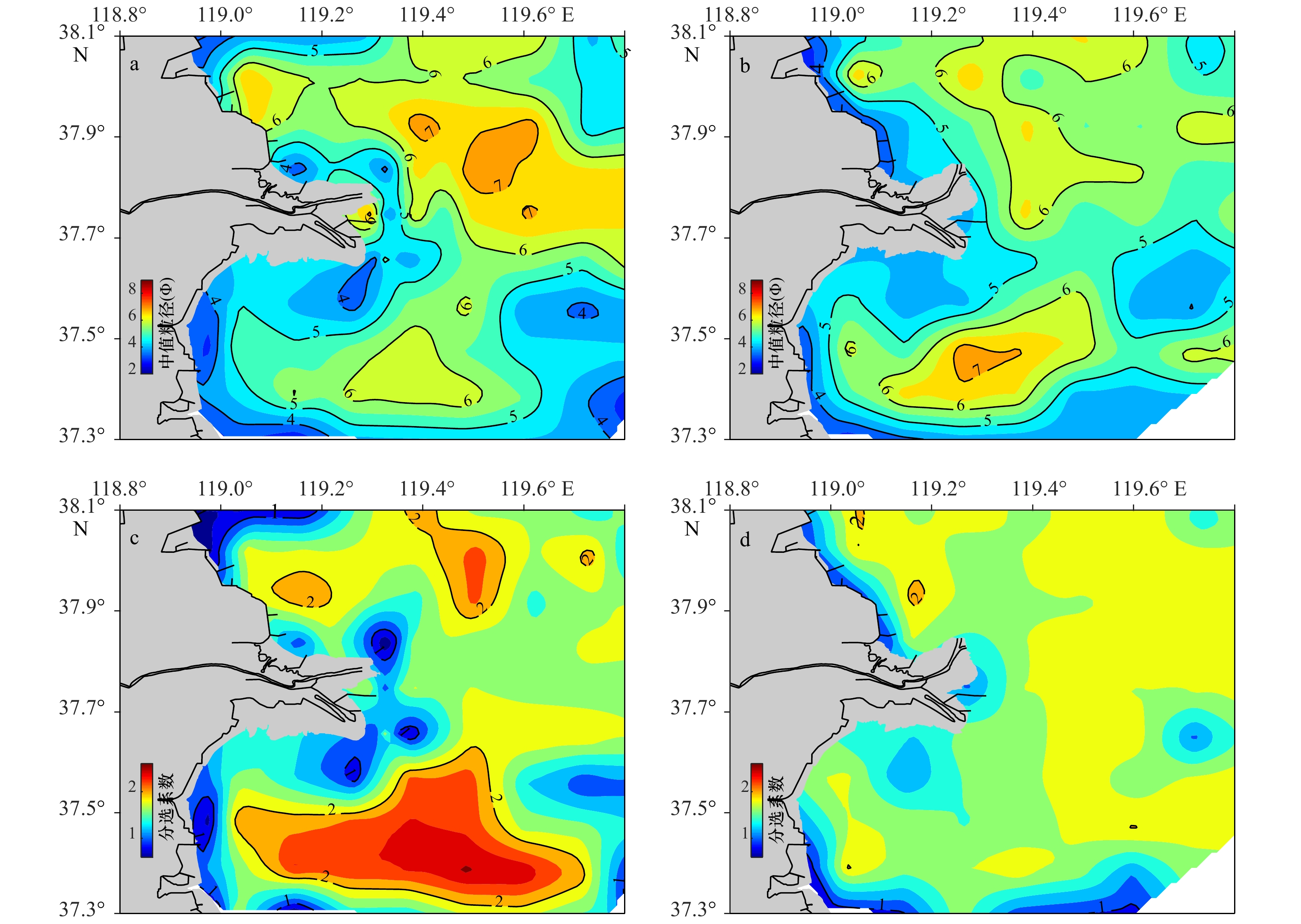
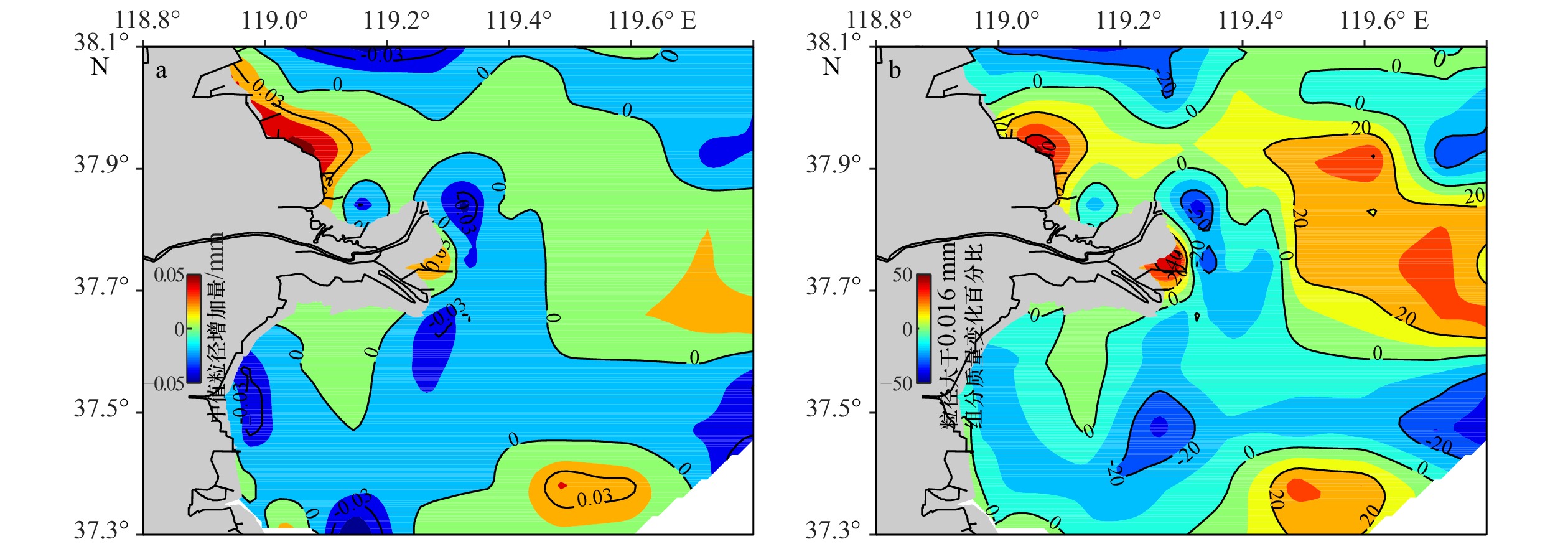
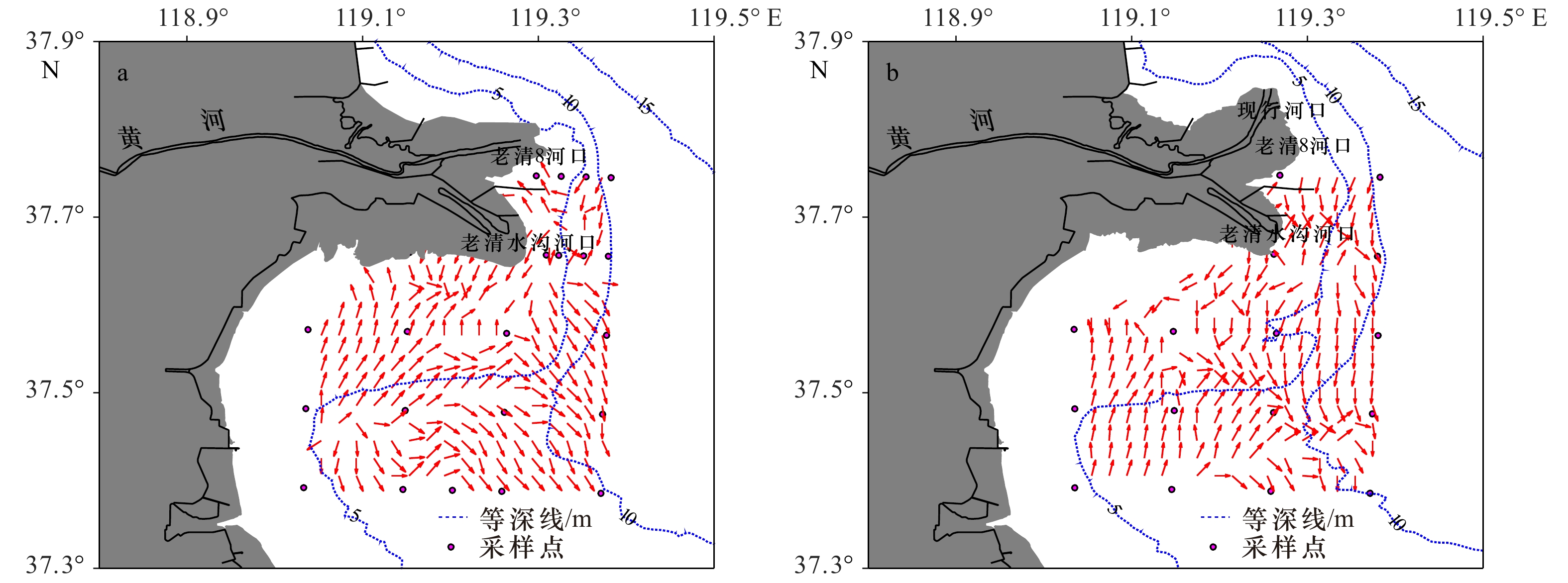
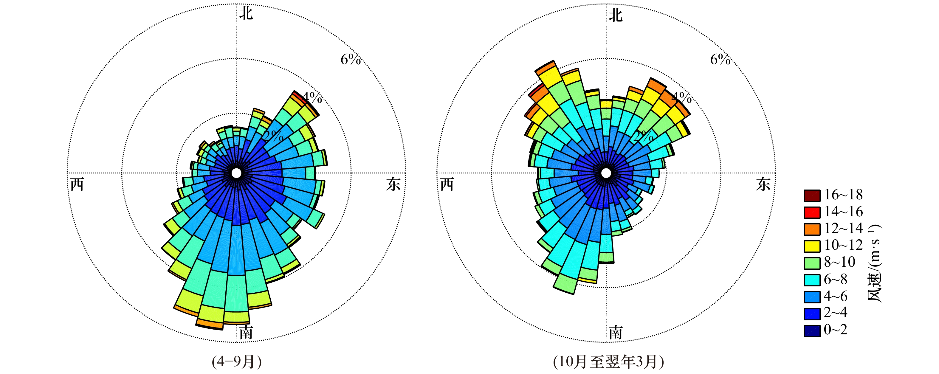
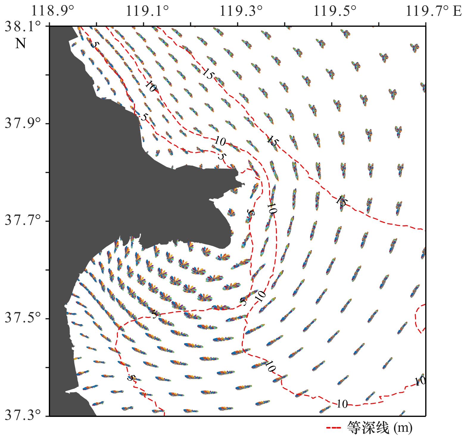
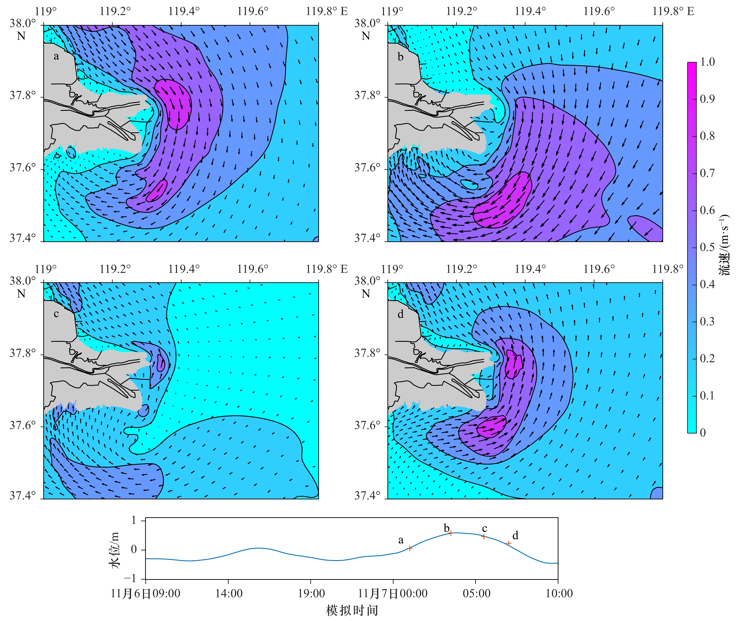
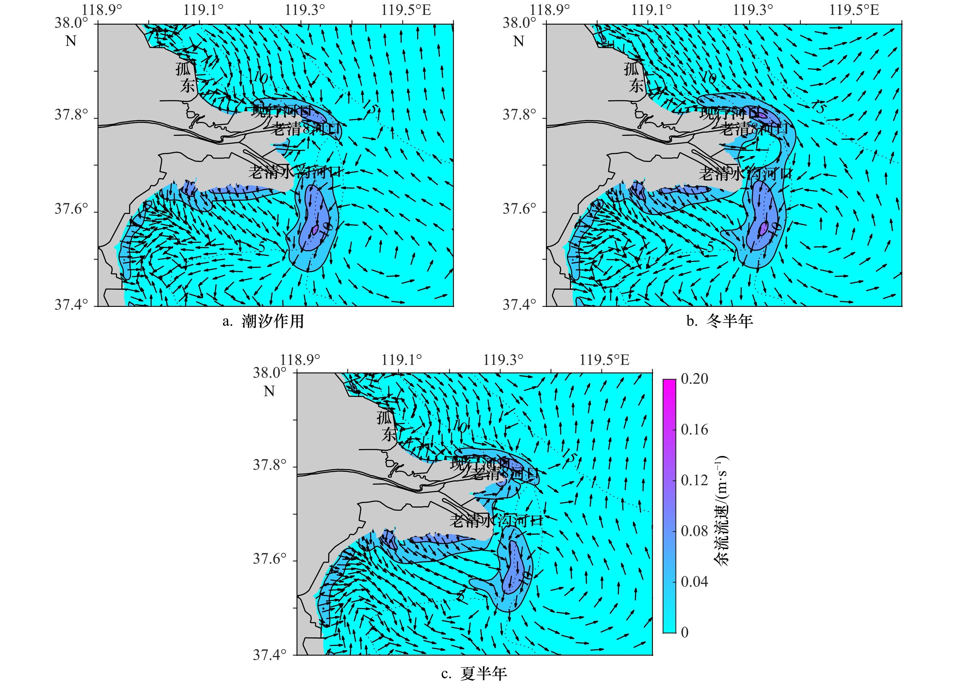
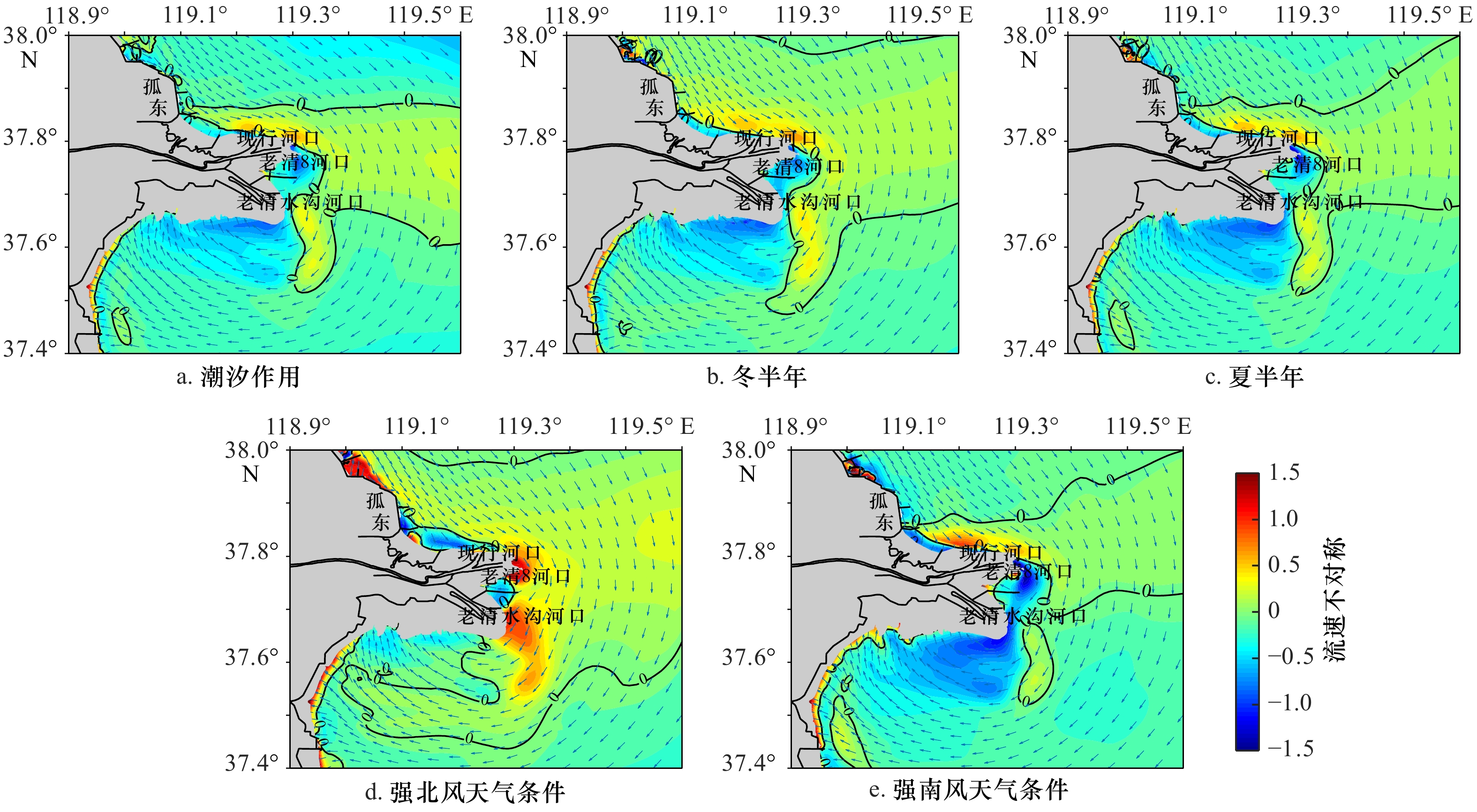
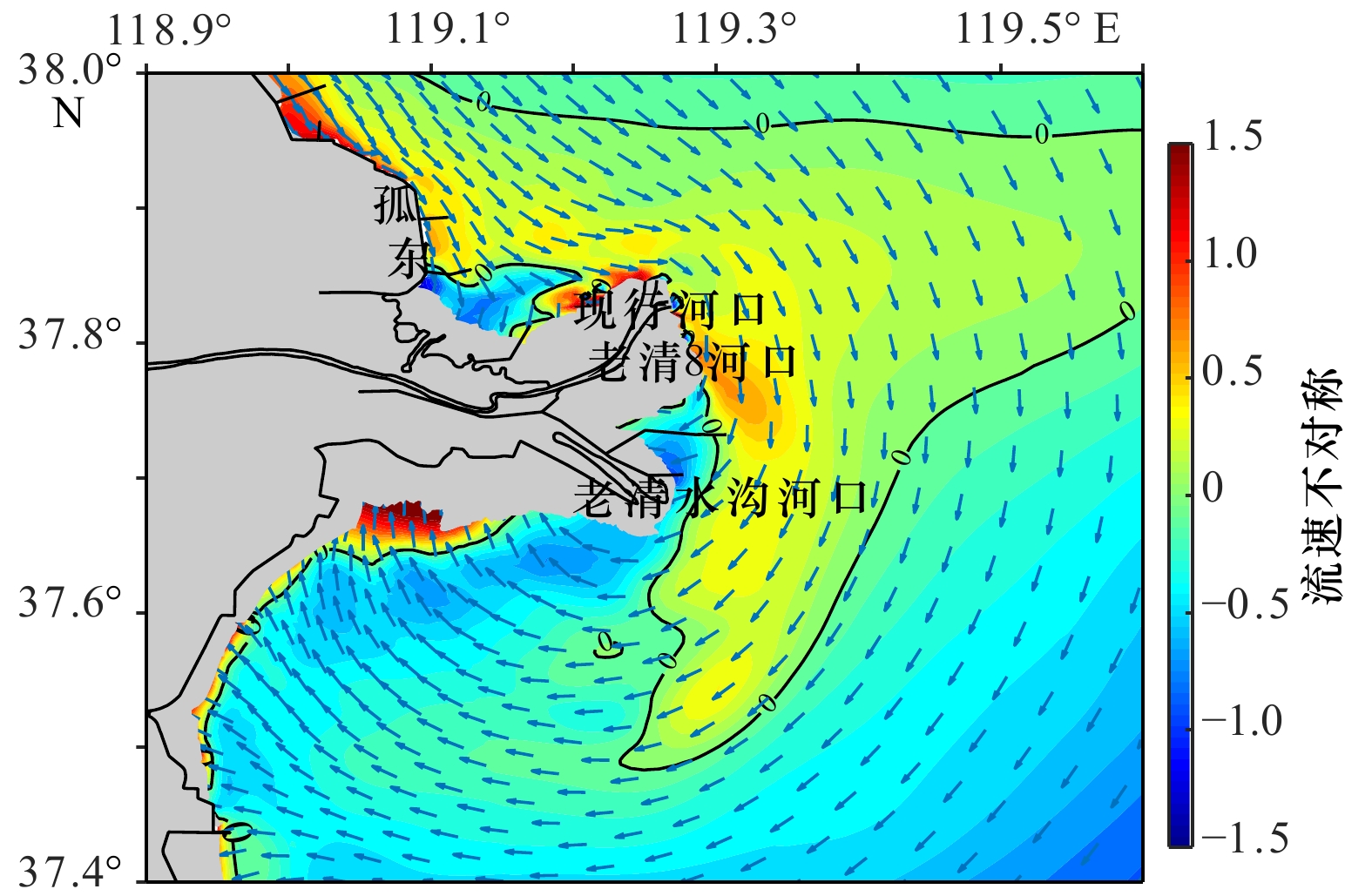
The asymmetry of flood and ebb plays an important role in the process of sediment transport and geomorphological evolution, which is a significant feature of the flow field in estuaries. The erosion and accumulation, sediment transport and sediment characteristics in the Huanghe River Estuary based on the measured topography, sediment particle size, hydrological and sediment observation data were analyzed in this paper. The Delft 3D model was used to simulate the flow field in the Huanghe River Estuary, and the spatial distribution of magnitude differences between flood and ebb velocities under different conditions were calculated. Combining the above, the dynamic mechanism of erosion and accretion in coastal area of the Huanghe River Estuary was discussed. The results show that there are multiple siltation and erosion centers distributed between the active river mouth and the Laizhou Bay. There is a noticeable asymmetry of flood and ebb velocities in the area, and there is the flood dominant area off the active river mouth, extending the Laizhou Bay southward in a tongue shape, while the near shore and the Laizhou Bay are dominated by ebb. The erosion and deposition in the Huanghe River Estuary are largely controlled by the spatial distribution of flow velocity asymmetry and the conversion of dominant flow. The strong north wind strengthens and expands flood-dominance, and promotes siltation and coarsening of sediment in the Laizhou Bay.
The asymmetry of flood and ebb plays an important role in the process of sediment transport and geomorphological evolution, which is a significant feature of the flow field in estuaries. The erosion and accumulation, sediment transport and sediment characteristics in the Huanghe River Estuary based on the measured topography, sediment particle size, hydrological and sediment observation data were analyzed in this paper. The Delft 3D model was used to simulate the flow field in the Huanghe River Estuary, and the spatial distribution of magnitude differences between flood and ebb velocities under different conditions were calculated. Combining the above, the dynamic mechanism of erosion and accretion in coastal area of the Huanghe River Estuary was discussed. The results show that there are multiple siltation and erosion centers distributed between the active river mouth and the Laizhou Bay. There is a noticeable asymmetry of flood and ebb velocities in the area, and there is the flood dominant area off the active river mouth, extending the Laizhou Bay southward in a tongue shape, while the near shore and the Laizhou Bay are dominated by ebb. The erosion and deposition in the Huanghe River Estuary are largely controlled by the spatial distribution of flow velocity asymmetry and the conversion of dominant flow. The strong north wind strengthens and expands flood-dominance, and promotes siltation and coarsening of sediment in the Laizhou Bay.


2021, 43(6): 26-34.
doi: 10.12284/hyxb2021096
Abstract:
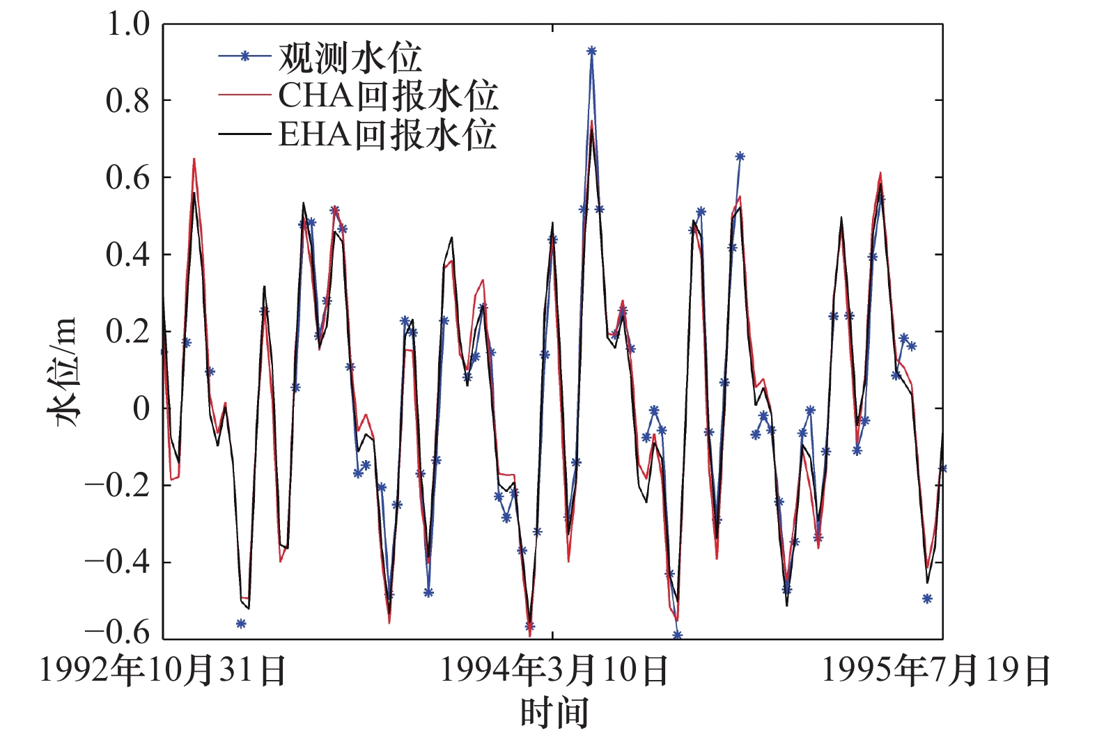
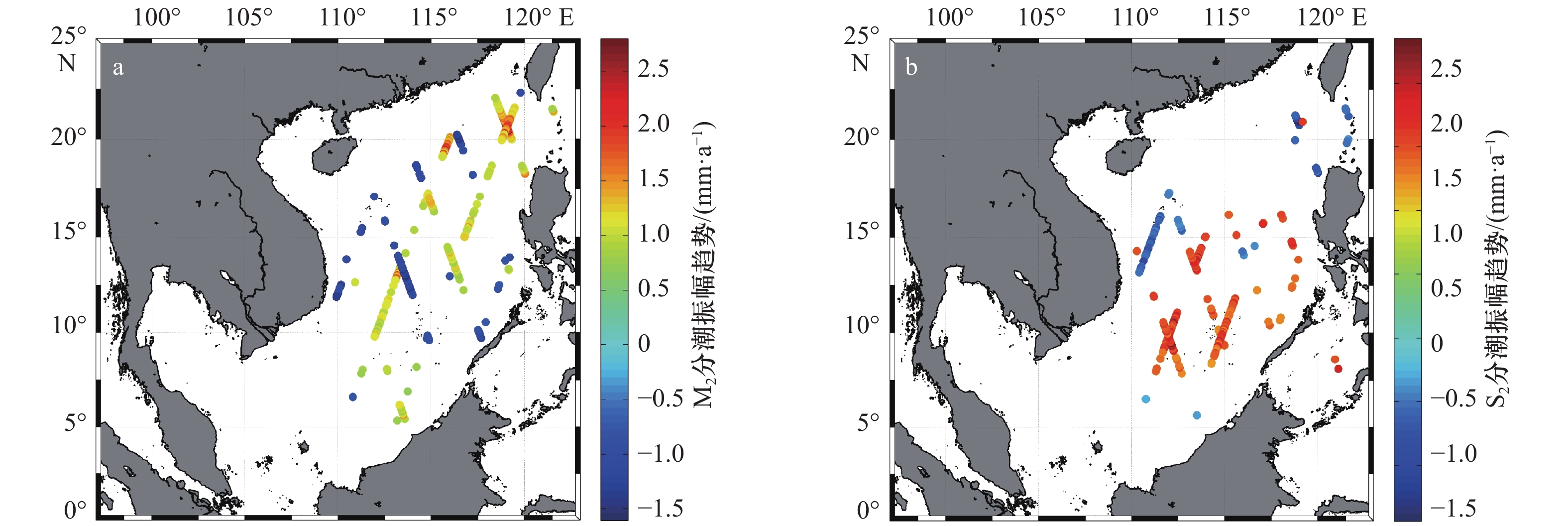
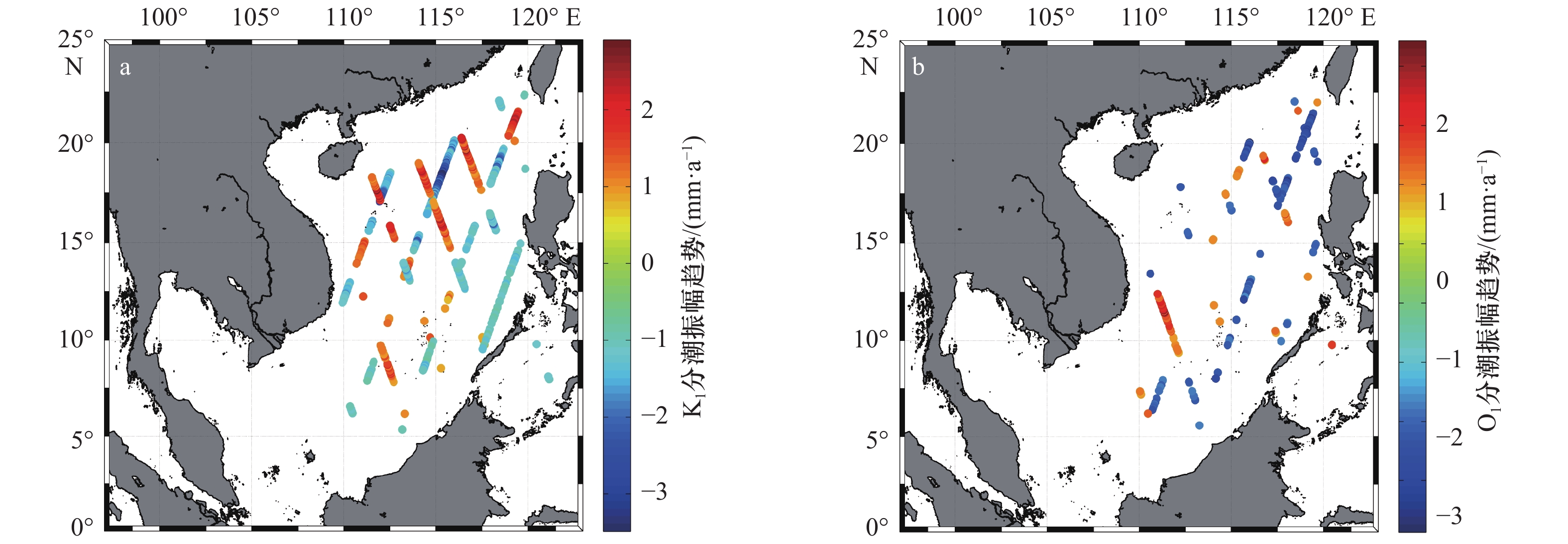
The study of tidal changes is of great significance in marine engineering, marine mapping as well as marine transportation. Because nearly all tide gauges are located in the coastal waters, previous studies mainly focus on tidal changes in the shallow waters. In the deep sea, due to the lack of long-term high-frequency sea level observations, tidal changes are remained unclear. Based on the tide gauge observations and satellite altimeter data, non-stationary tidal harmonic analysis toolbox S_TIDE to extract the long-term trend of amplitudes of four major constituents in the South China Sea is first used in this paper. Results show that in most areas of the South China Sea, the amplitudes of four major constituents are stable and have no significant positive or negative trends. In minor areas of the South China Sea, the amplitudes of four major constituents have significant trends. The largest positive trends can reach 2.91 mm/a and the largest negative trends can reach 3.50 mm/a. The long-term trends of tidal amplitudes in this area may be related to the change of the surface expression of internal tides. The tides observed by satellite contain not only barotropic tides but also the surface expression of internal tides. The internal tides as well as their surface expression in the South China Sea are strongest in the world. The changes of ocean stratification can influence the generation, propagation and dissipation of internal tides as well as their surface expression and eventually induce the long-term trends of tidal amplitudes in the South China Sea.
The study of tidal changes is of great significance in marine engineering, marine mapping as well as marine transportation. Because nearly all tide gauges are located in the coastal waters, previous studies mainly focus on tidal changes in the shallow waters. In the deep sea, due to the lack of long-term high-frequency sea level observations, tidal changes are remained unclear. Based on the tide gauge observations and satellite altimeter data, non-stationary tidal harmonic analysis toolbox S_TIDE to extract the long-term trend of amplitudes of four major constituents in the South China Sea is first used in this paper. Results show that in most areas of the South China Sea, the amplitudes of four major constituents are stable and have no significant positive or negative trends. In minor areas of the South China Sea, the amplitudes of four major constituents have significant trends. The largest positive trends can reach 2.91 mm/a and the largest negative trends can reach 3.50 mm/a. The long-term trends of tidal amplitudes in this area may be related to the change of the surface expression of internal tides. The tides observed by satellite contain not only barotropic tides but also the surface expression of internal tides. The internal tides as well as their surface expression in the South China Sea are strongest in the world. The changes of ocean stratification can influence the generation, propagation and dissipation of internal tides as well as their surface expression and eventually induce the long-term trends of tidal amplitudes in the South China Sea.


2021, 43(6): 35-44.
doi: 10.12284/hyxb2021076
Abstract:
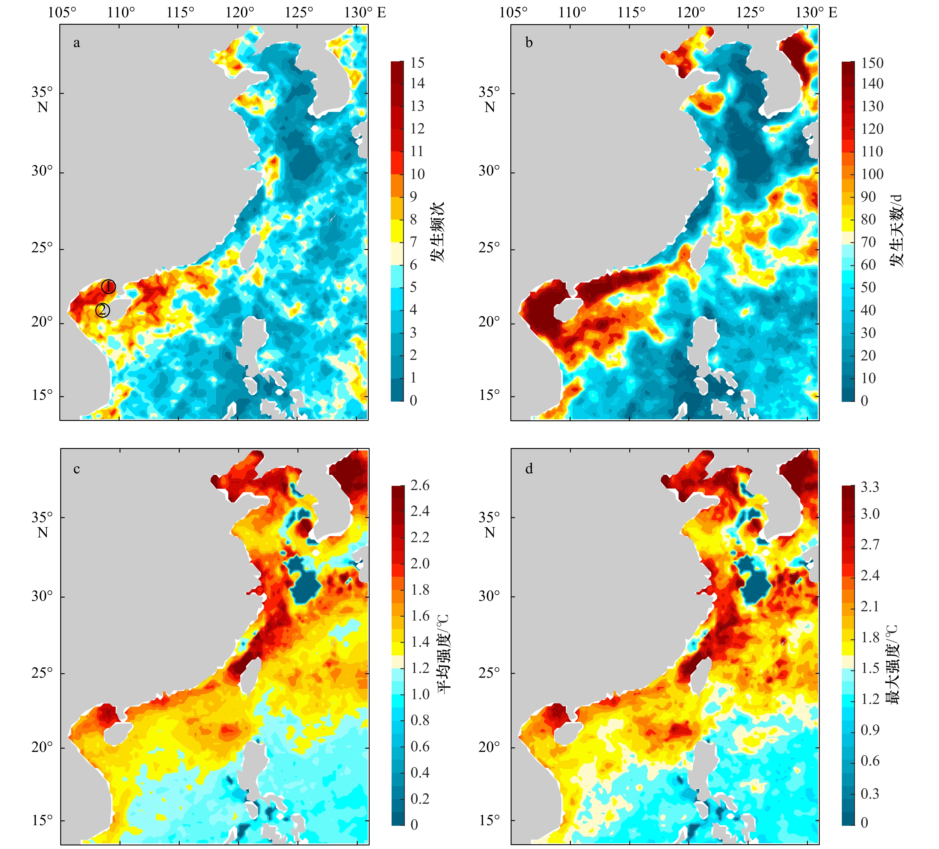
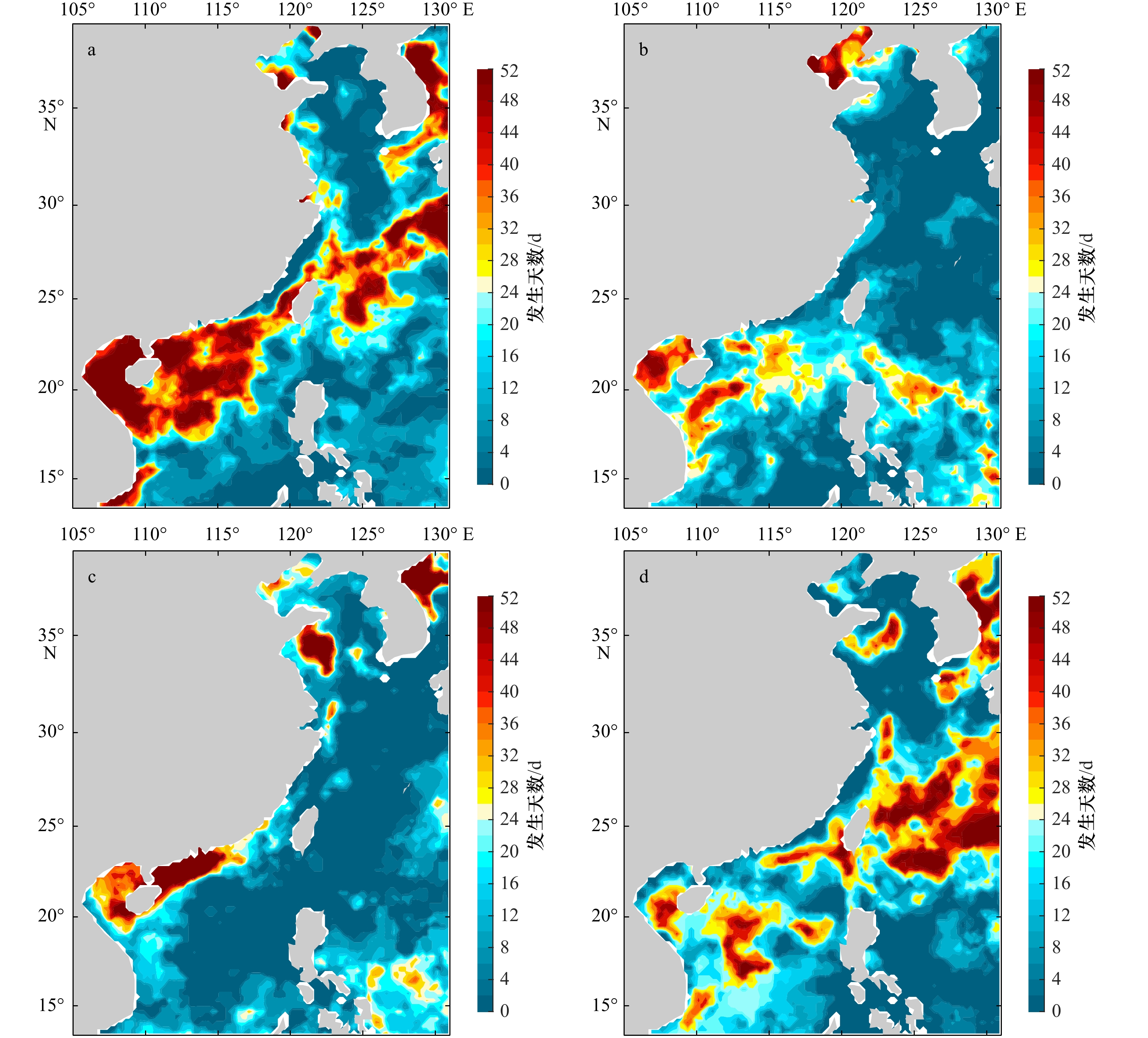
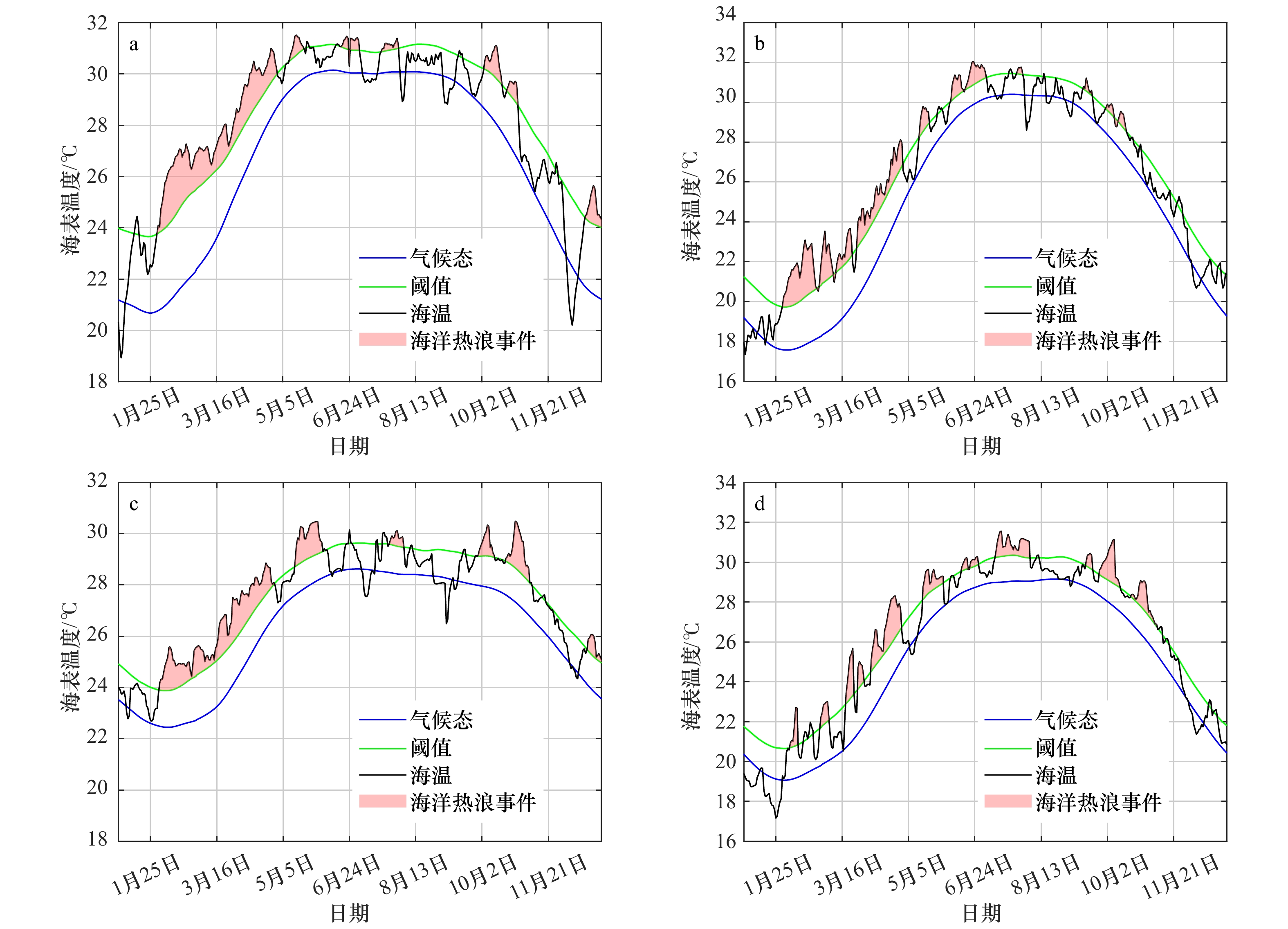
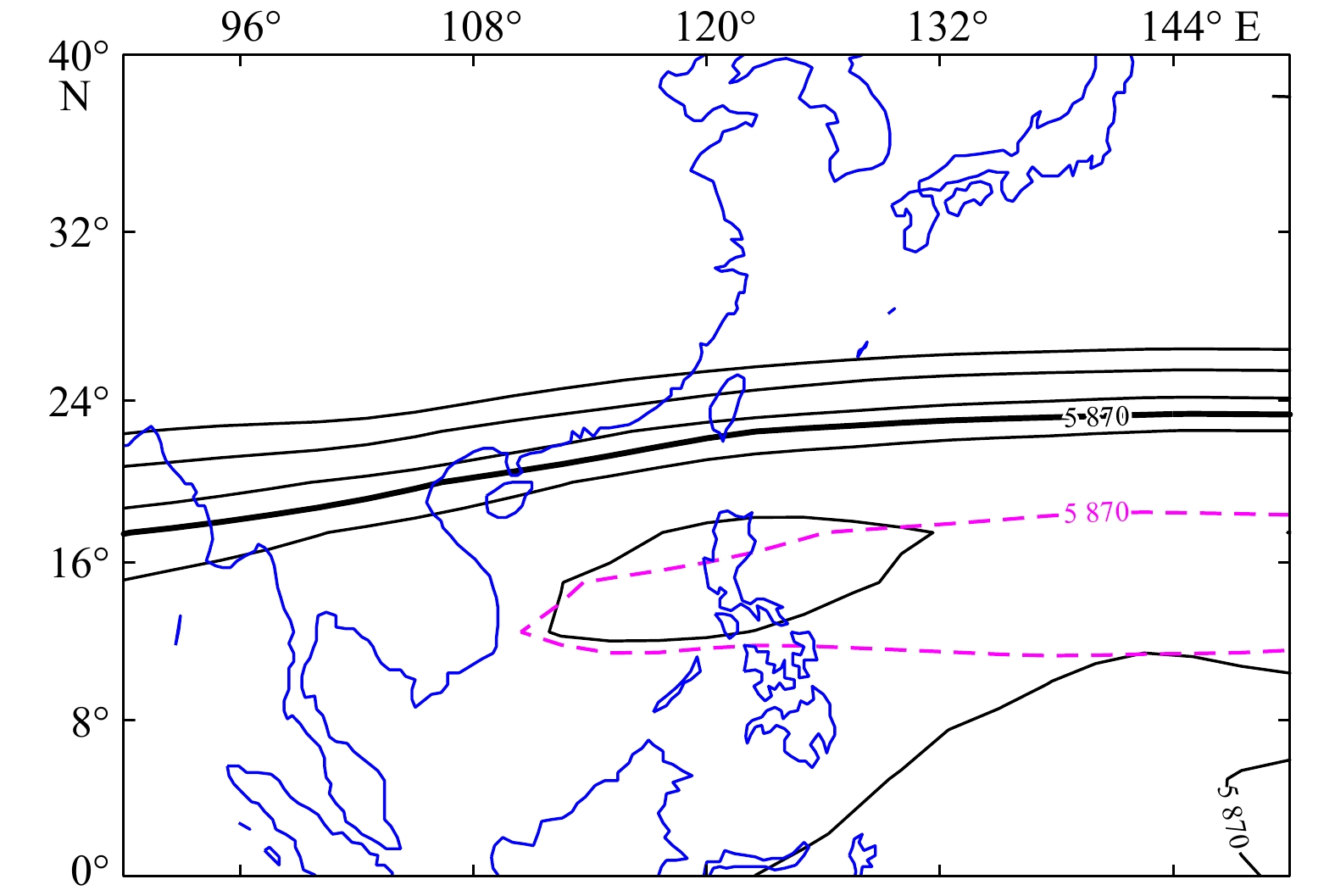
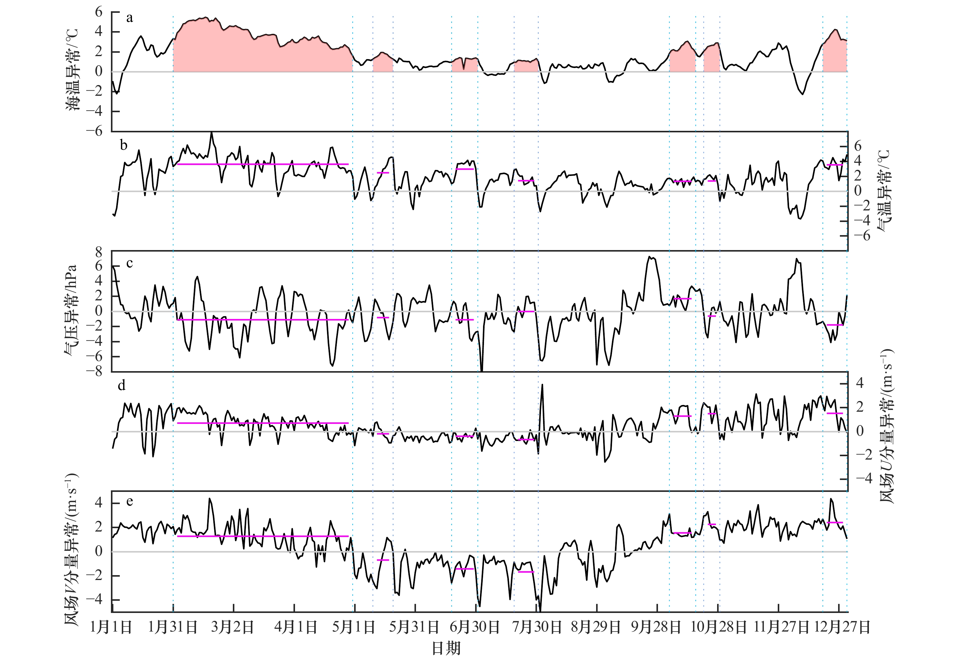
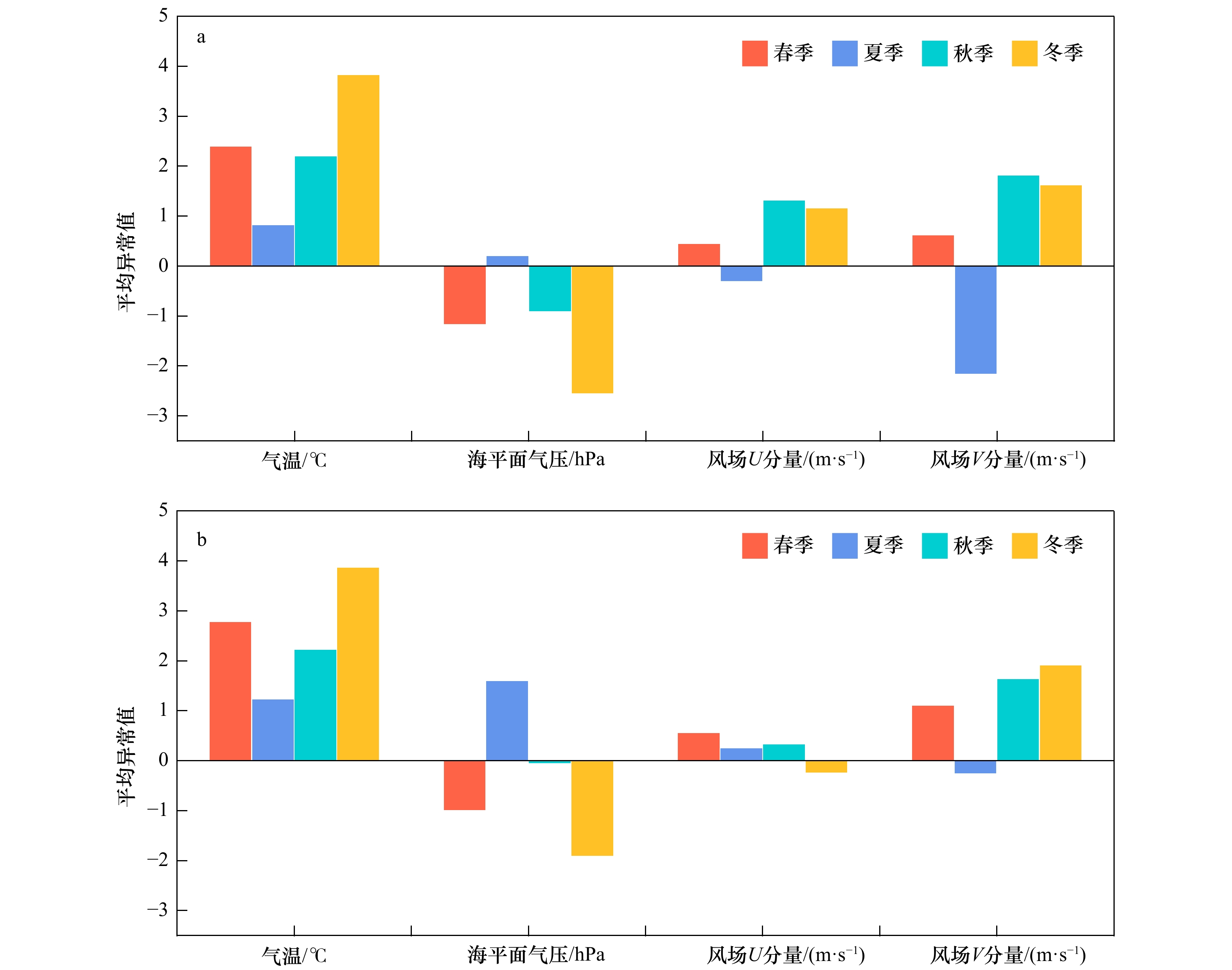
Marine heatwave, considered as events with prolonged anomalously high sea surface temperature in certain sea areas. The occurrence of marine heatwave could impact the function and service of marine ecosystem. In recent years, the marine heatwave in the China offshore become more frequent, and attract considerable attention. Used a range of ocean temperature data including daily satellite observations and daily in situ measurements, we analysised the characteristics of marine heatwave in the China offshore in 2019. Results show that in 2019, the frequency of marine heatwave is higher in the sea areas around Hainan Island, the Changjiang River Estuary, the Bohai Sea and the sea areas off Jiangsu Province, with the frequency of 7−12 times. The marine heatwave duration in the Beibu Gulf lasts the longest, more than 150 days. In addition, took the classical marine heatwave that last from February to April in Beibu Gulf as an example, anomaly characteristics of air temperature, sea level pressure and wind during the event period were investigated specifically and the corresponding relationships between the marine heatwave and meteorological background fields in different seasons in Beibu Gulf was further studied. On the whole, the higher air temperature, weaker East Asian winter monsoon, larger area and the northward and westward extension of subtropical high are the important factors for the occurrence and maintenance of the marine heatwave in the Beibu Gulf in the early 2019.
Marine heatwave, considered as events with prolonged anomalously high sea surface temperature in certain sea areas. The occurrence of marine heatwave could impact the function and service of marine ecosystem. In recent years, the marine heatwave in the China offshore become more frequent, and attract considerable attention. Used a range of ocean temperature data including daily satellite observations and daily in situ measurements, we analysised the characteristics of marine heatwave in the China offshore in 2019. Results show that in 2019, the frequency of marine heatwave is higher in the sea areas around Hainan Island, the Changjiang River Estuary, the Bohai Sea and the sea areas off Jiangsu Province, with the frequency of 7−12 times. The marine heatwave duration in the Beibu Gulf lasts the longest, more than 150 days. In addition, took the classical marine heatwave that last from February to April in Beibu Gulf as an example, anomaly characteristics of air temperature, sea level pressure and wind during the event period were investigated specifically and the corresponding relationships between the marine heatwave and meteorological background fields in different seasons in Beibu Gulf was further studied. On the whole, the higher air temperature, weaker East Asian winter monsoon, larger area and the northward and westward extension of subtropical high are the important factors for the occurrence and maintenance of the marine heatwave in the Beibu Gulf in the early 2019.


2021, 43(6): 45-61.
doi: 10.12284/hyxb2021080
Abstract:
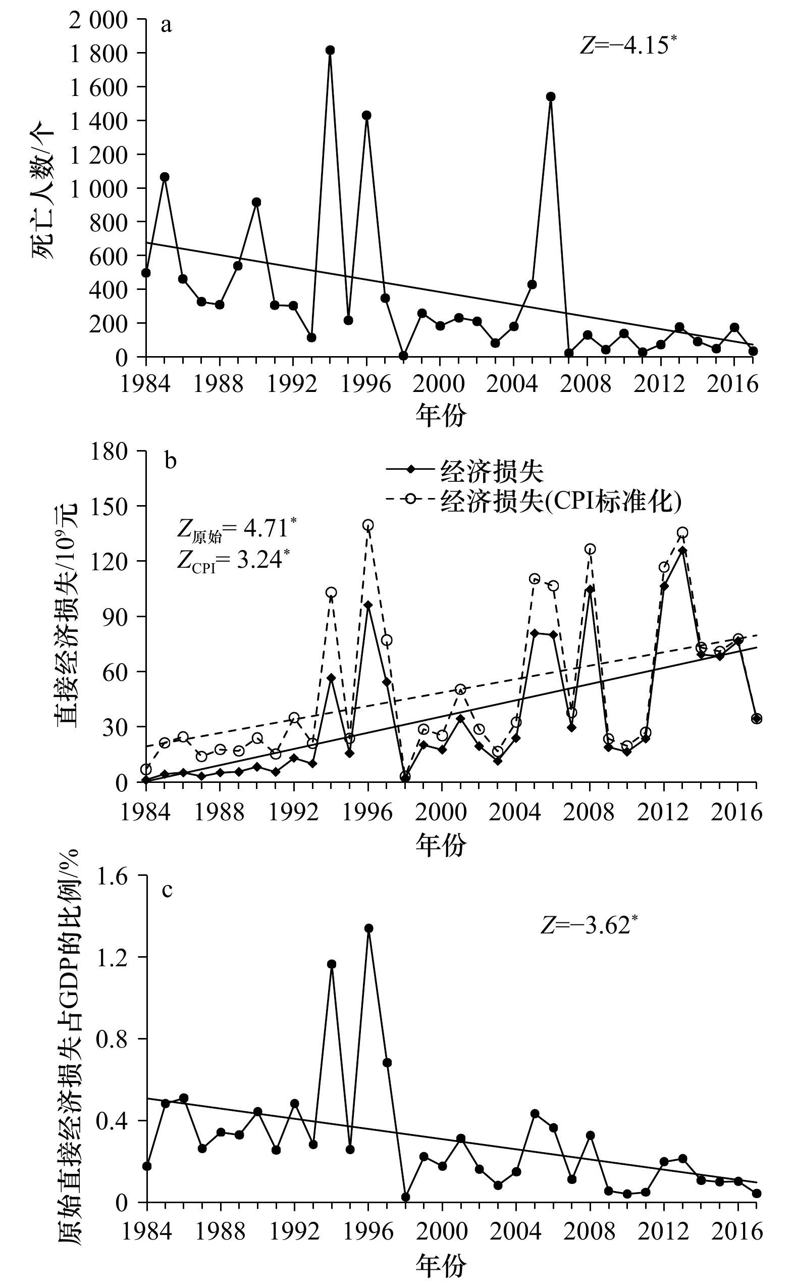
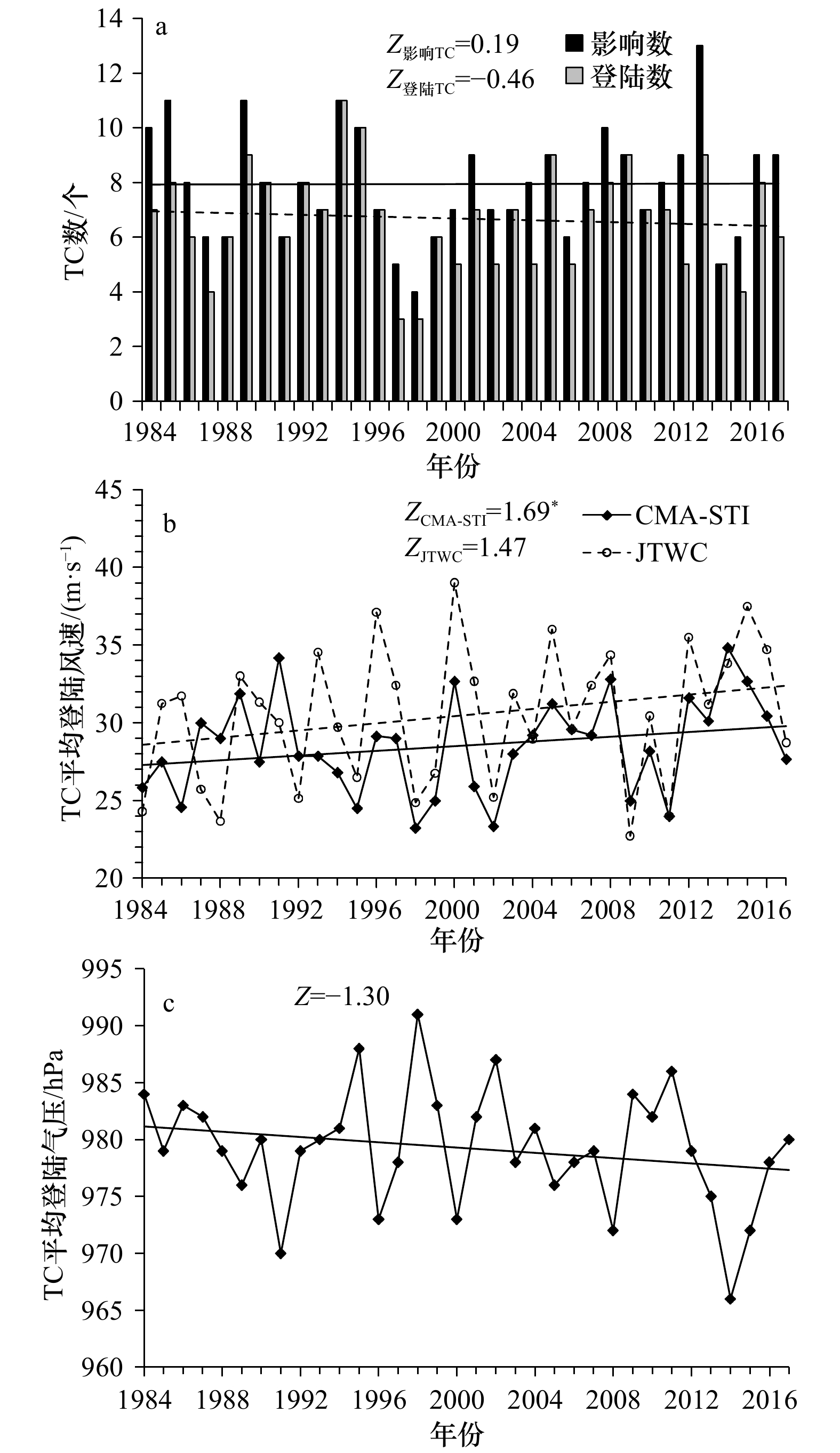
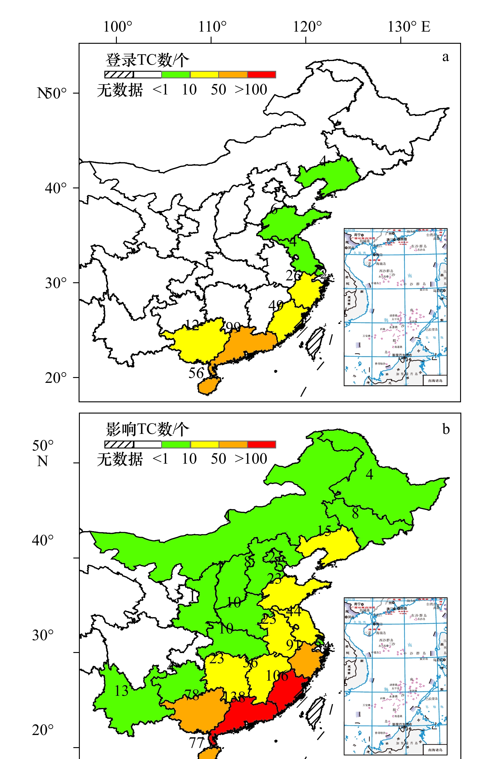
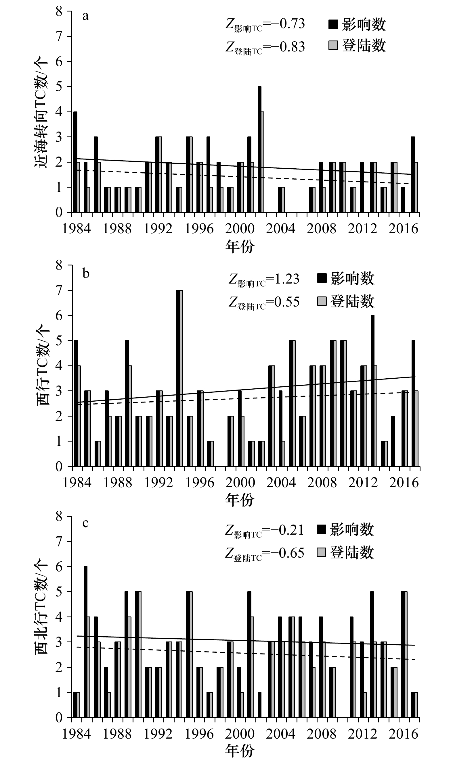
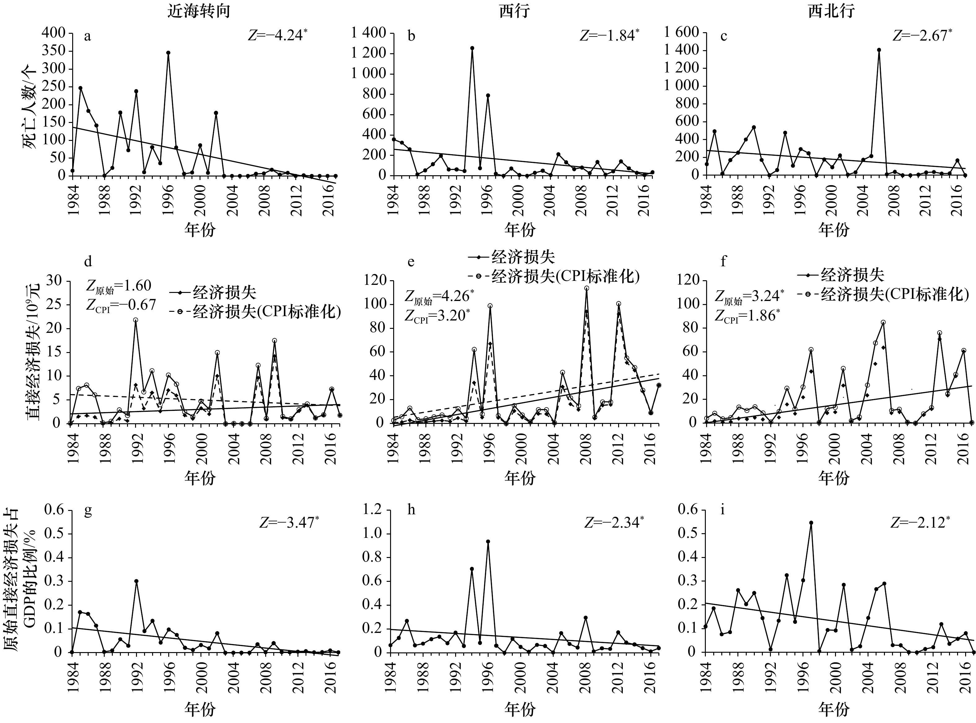
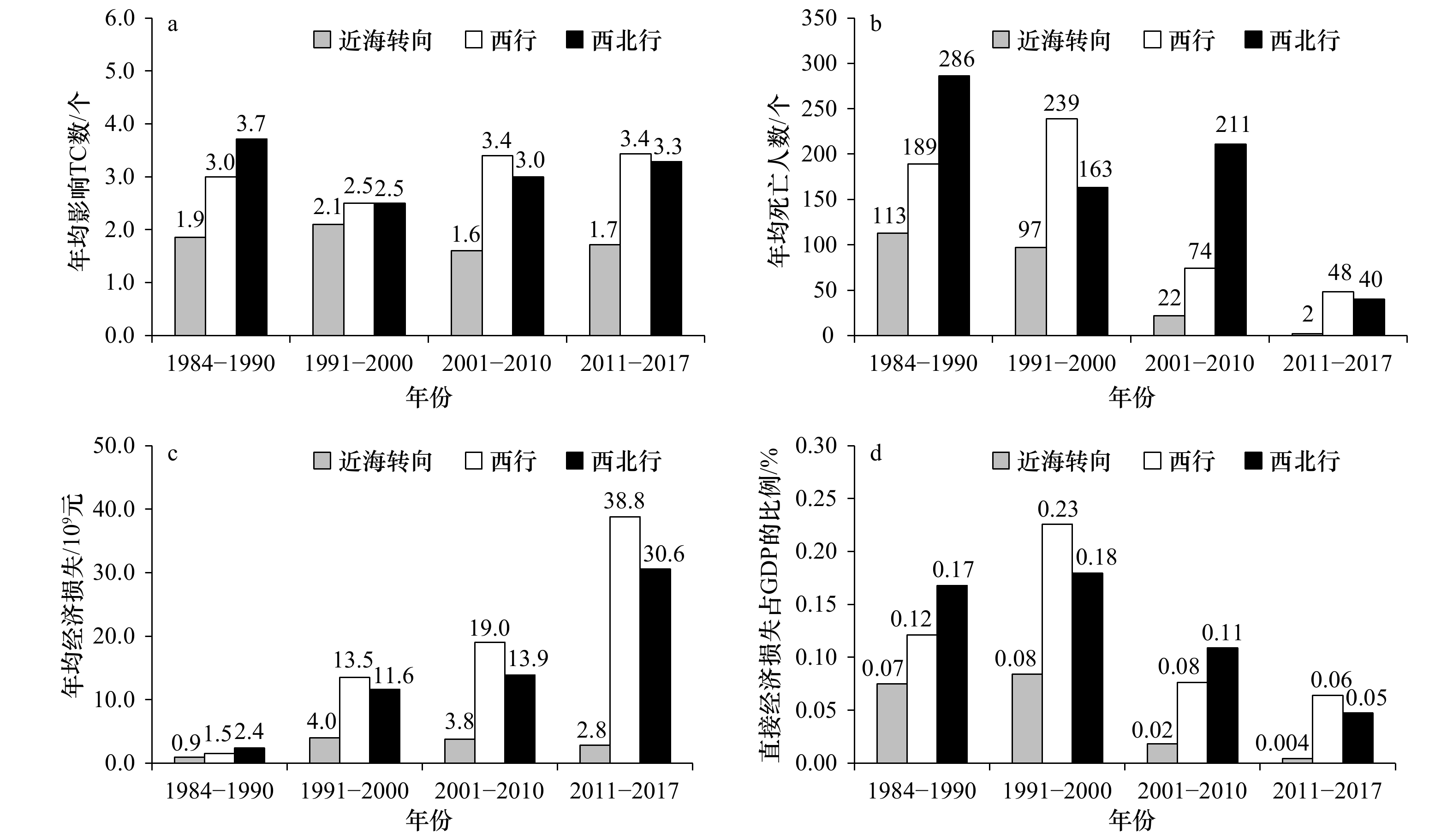
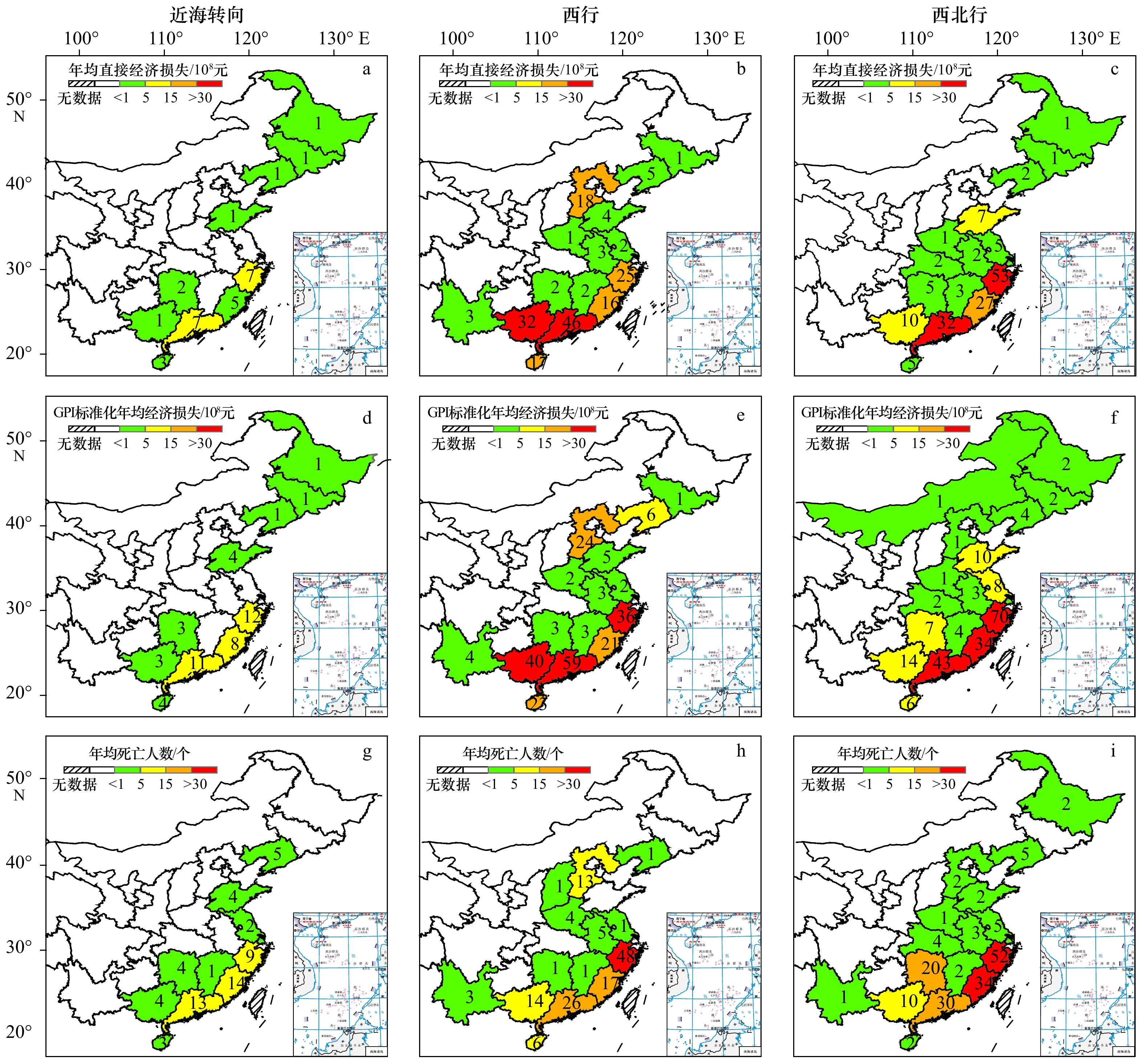
Based on tropical cyclone (TC) disaster data and the best-track database from Shanghai Typhoon Institute of China Meteorological Administration (CMA-STI) during 1984 to 2017, this study analyzed the spatial-temporal characteristics of TC disaster in China and their differences for the three prevailing tracks, along with the discussion of the overland duration and its potential risk. Main results of this study were summarized as follows: (1) There was a significant upward trend with direct TC-associated economic losses, while the proportion of losses to Gross Domestic Product (GDP) and the deaths showed a downward trend. (2) TC-associated economic losses accompanied with the three prevailing TC tracks showed a substantial difference. The recurving TCs tended to be less and lower impact, while westward and west-northward TCs appeared to be more and higher impact in China. Particularly, more frequent TCs with westward movement affected the Guangdong, Guangxi and Hainan provinces. TCs tending to west-northward tracks mainly caused a serious TC-associated disaster in Guangdong, Fujian, and Zhejiang provinces. (3) The average overland duration, as a potential index for TC-associated disaster, showed an upward trend. Note that the reasons on the changes of TC overland duration for the three prevailing tracks appeared to be different. The increased average overland duration for recurving TCs were likely to relate to the decreased in TC average overland translation speed. In contrast, the increased average overland duration of westward and west-northward moving TCs were possibly due to the increased average distance that TCs traveled over land.
Based on tropical cyclone (TC) disaster data and the best-track database from Shanghai Typhoon Institute of China Meteorological Administration (CMA-STI) during 1984 to 2017, this study analyzed the spatial-temporal characteristics of TC disaster in China and their differences for the three prevailing tracks, along with the discussion of the overland duration and its potential risk. Main results of this study were summarized as follows: (1) There was a significant upward trend with direct TC-associated economic losses, while the proportion of losses to Gross Domestic Product (GDP) and the deaths showed a downward trend. (2) TC-associated economic losses accompanied with the three prevailing TC tracks showed a substantial difference. The recurving TCs tended to be less and lower impact, while westward and west-northward TCs appeared to be more and higher impact in China. Particularly, more frequent TCs with westward movement affected the Guangdong, Guangxi and Hainan provinces. TCs tending to west-northward tracks mainly caused a serious TC-associated disaster in Guangdong, Fujian, and Zhejiang provinces. (3) The average overland duration, as a potential index for TC-associated disaster, showed an upward trend. Note that the reasons on the changes of TC overland duration for the three prevailing tracks appeared to be different. The increased average overland duration for recurving TCs were likely to relate to the decreased in TC average overland translation speed. In contrast, the increased average overland duration of westward and west-northward moving TCs were possibly due to the increased average distance that TCs traveled over land.


2021, 43(6): 62-70.
doi: 10.12284/hyxb2021142
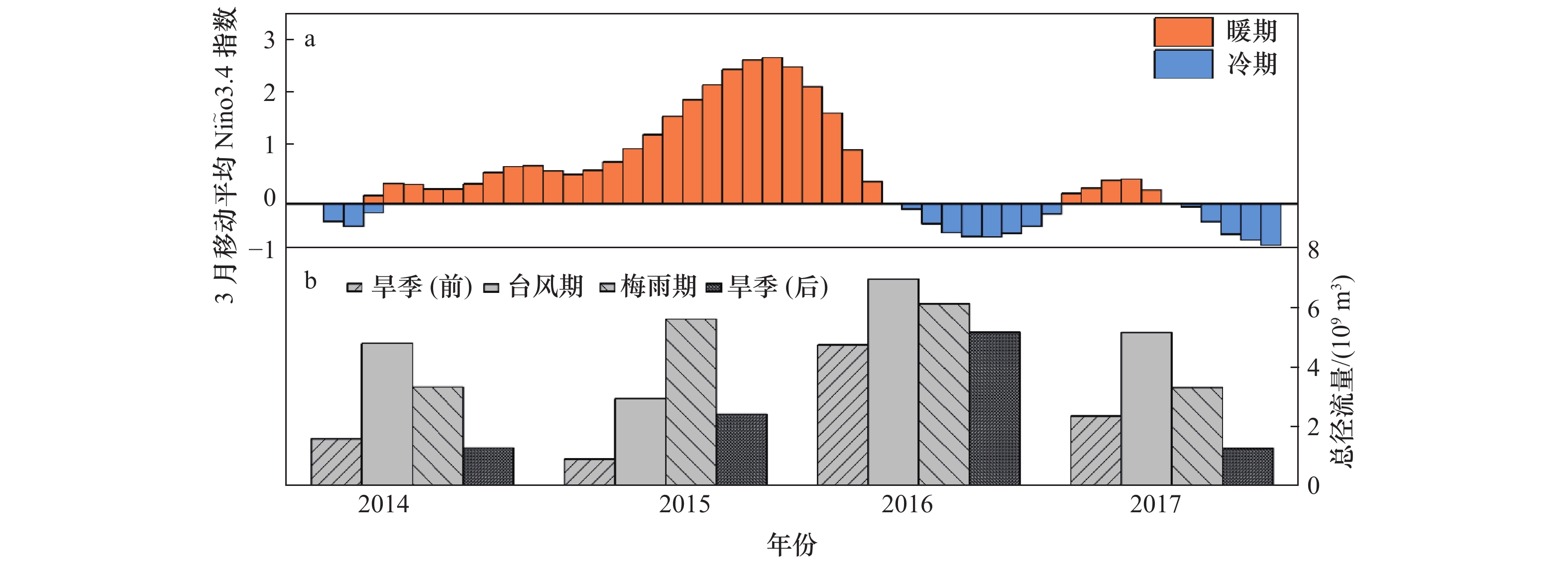
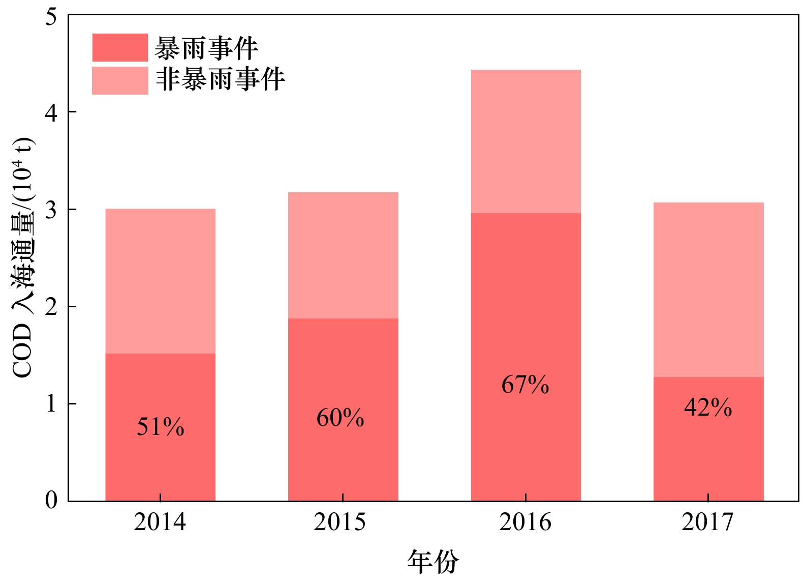
Abstract:
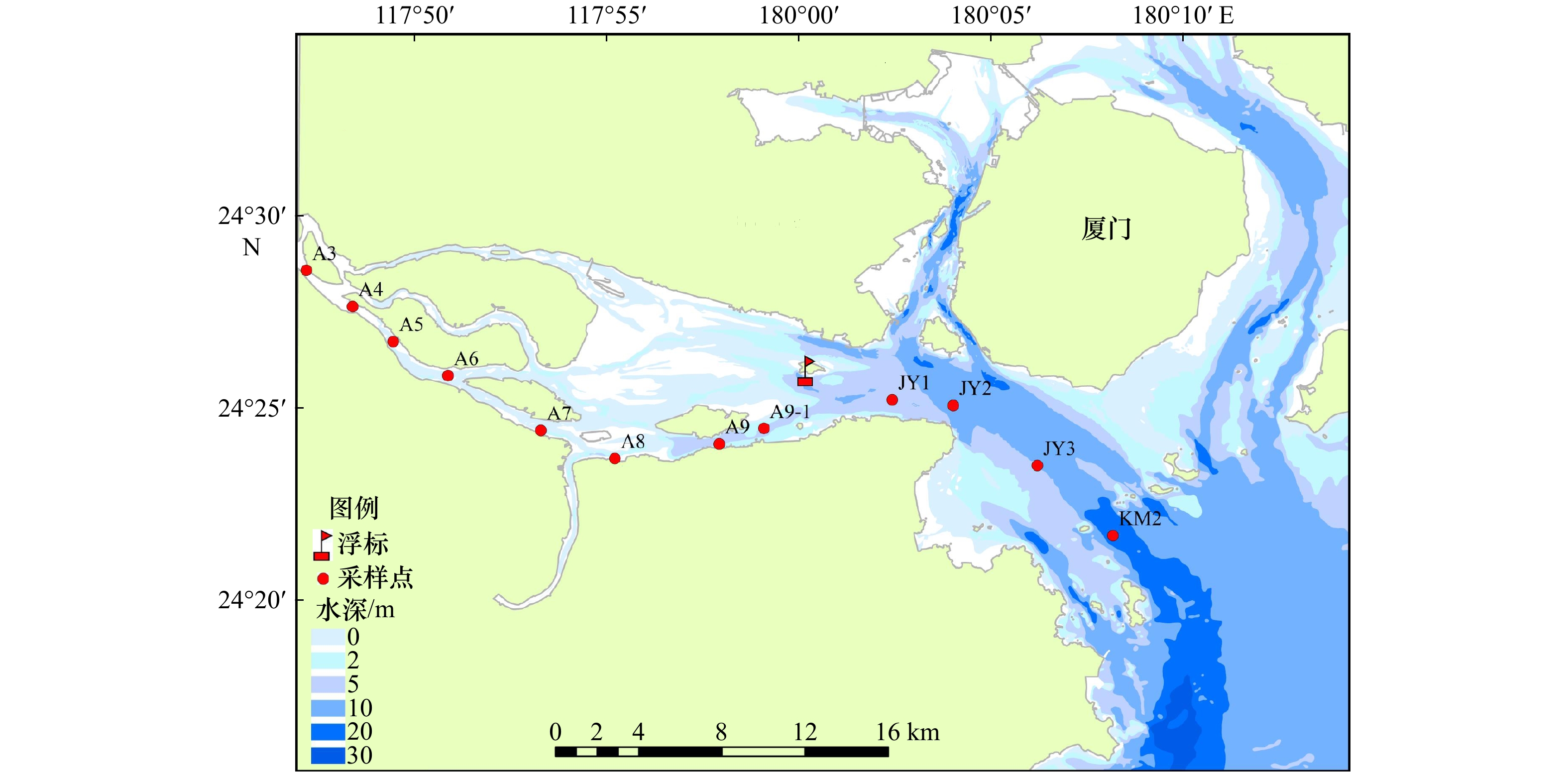
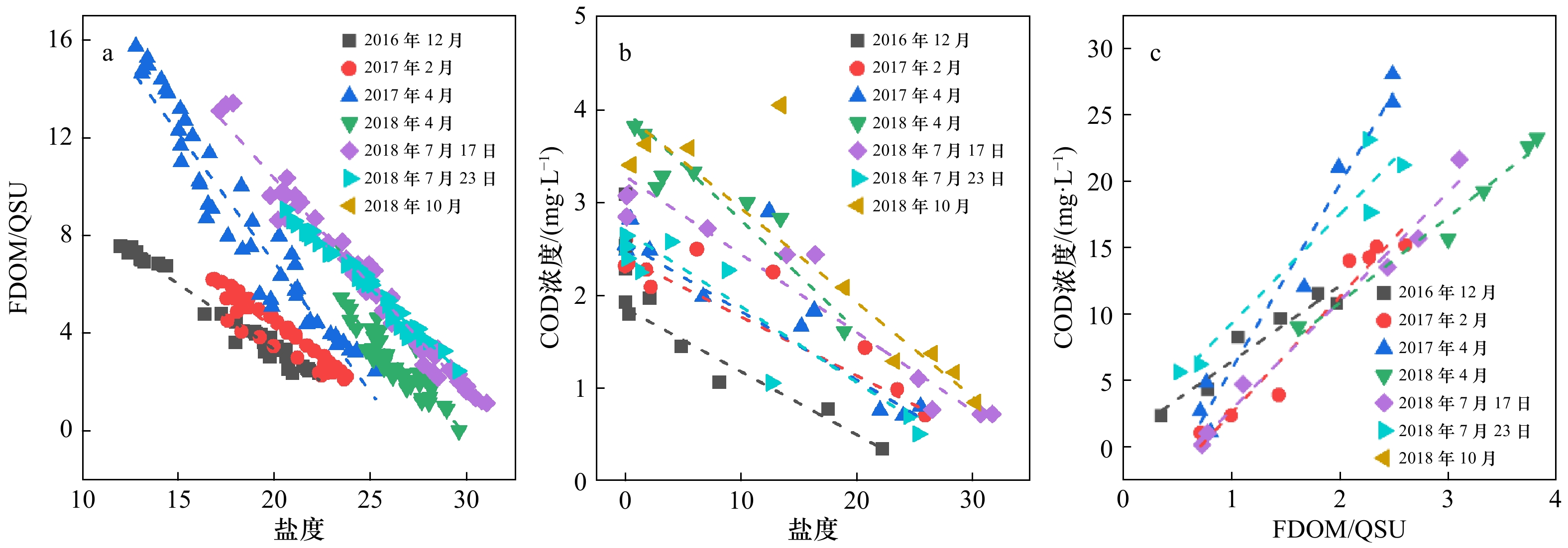
Online monitoring of pollutants exporting into coastal waters is one of the key technique to realize marine pollution control and coordination of monitoring and management. In this study, based on salinity and fluorescence dissolved organic matter (FDOM) sensor data between 2014−2018 from a multi-parameter buoy deployed in Jiulong River Estuary, a rapid inversion model of chemical oxygen demand (COD) was established. Daily river end member COD concentrations were then extrapolated by effective concentration method. Combined with daily runoff data, daily estuarine export fluxes of COD between 2014 and 2017 were estimated. The factors controlling the flux variations were quantified by flux decomposition model. The results indicated: (1) The average concentration deviation of the inversion was (10.4±8.8)%, indicating the good reliability and stability of inversion model. (2) On seasonal scale, COD concentration in dry season of 2016 was lower than the other dry seasons, which was regulated by 2015−2016 super El Niño events. However, the sharp increase of runoff still significantly increased the COD export flux. (3) On annual scale, the COD export flux in 2016 from the Jiulong River 4.4 ×10⁴ t/a was significantly higher than the other three years (3.0−3.2)×104 t/a. The abnormal precipitation in 2016 caused by 2015−2016 El Niño event was the major reason for such yearly variation. This study highlighted the application of online FDOM sensor system for high frequency monitoring of COD export. This would help to achieve long-term continuous high-frequency monitoring of land-based pollutants and their fluxes into the sea and their regulatory factors. This would provide important technical support for marine ecological environmental protection and management.
Online monitoring of pollutants exporting into coastal waters is one of the key technique to realize marine pollution control and coordination of monitoring and management. In this study, based on salinity and fluorescence dissolved organic matter (FDOM) sensor data between 2014−2018 from a multi-parameter buoy deployed in Jiulong River Estuary, a rapid inversion model of chemical oxygen demand (COD) was established. Daily river end member COD concentrations were then extrapolated by effective concentration method. Combined with daily runoff data, daily estuarine export fluxes of COD between 2014 and 2017 were estimated. The factors controlling the flux variations were quantified by flux decomposition model. The results indicated: (1) The average concentration deviation of the inversion was (10.4±8.8)%, indicating the good reliability and stability of inversion model. (2) On seasonal scale, COD concentration in dry season of 2016 was lower than the other dry seasons, which was regulated by 2015−2016 super El Niño events. However, the sharp increase of runoff still significantly increased the COD export flux. (3) On annual scale, the COD export flux in 2016 from the Jiulong River 4.4 ×10⁴ t/a was significantly higher than the other three years (3.0−3.2)×104 t/a. The abnormal precipitation in 2016 caused by 2015−2016 El Niño event was the major reason for such yearly variation. This study highlighted the application of online FDOM sensor system for high frequency monitoring of COD export. This would help to achieve long-term continuous high-frequency monitoring of land-based pollutants and their fluxes into the sea and their regulatory factors. This would provide important technical support for marine ecological environmental protection and management.


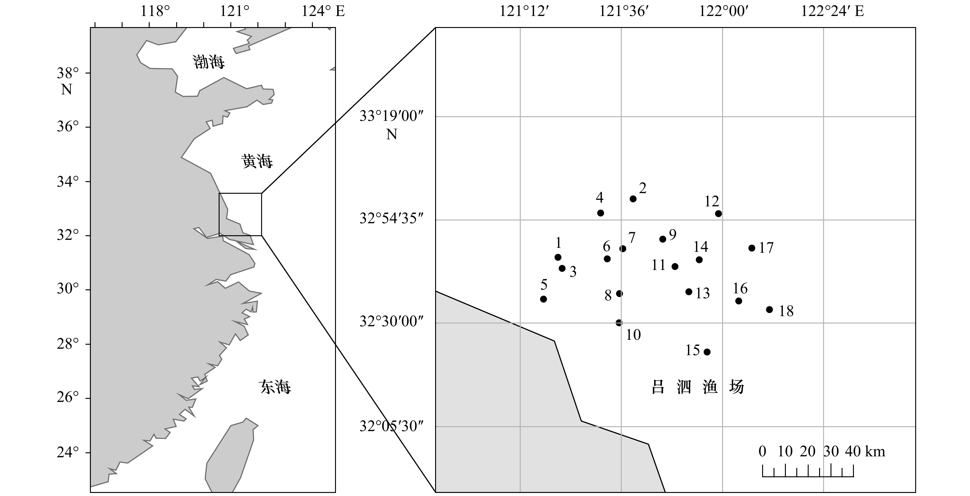
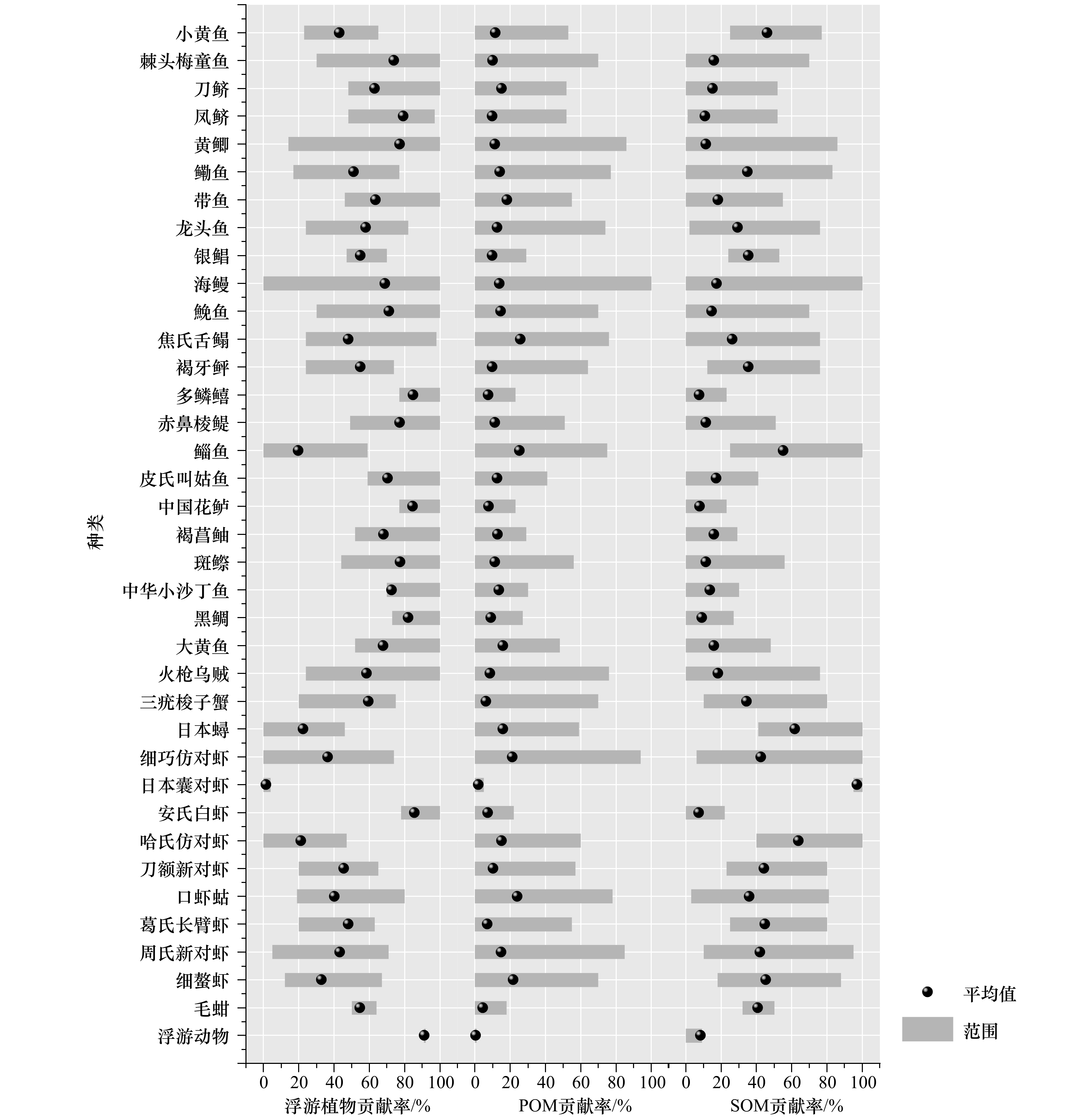
2021, 43(6): 71-80.
doi: 10.12284/hyxb2021066
Abstract:
Trophic level among main organisms in costal water of Lüsi fishing ground in summer, 2018, were analyzed in this study by stable isotope method. Using IsoSource model, we calculated potential carbon source contribution of the phytoplankton, POM and SOM of consumers, and then compared the former and latter TLs variation of main organisms by overlapping potential carbon source influence. Results showed that phytoplankton and SOM were main potential carbon source of main organisms in costal water of Lüsi fishing ground in summer. Two trophic level spectrums were constructed by overlapping three potential carbon sources and a single species as the baseline organisms, respectively. The trophic level of the right trophic level spectrum ranged from 1.74 to 3.92, which was averagely 0.19 lower than that of the left trophic level spectrum. Although the overall trend was unchanged, the trophic positions of some fish and most shrimps were changed in two spectrums. The baseline organisms in the right trophic level spectrum changed with the different stacking ratio of potential carbon sources, which could reflect the trophic level more effectively and was more suitable for organisms at low trophic levels, such as shrimp and crabs. However, this had little impact on fish in the position of middle and advanced consumers.
Trophic level among main organisms in costal water of Lüsi fishing ground in summer, 2018, were analyzed in this study by stable isotope method. Using IsoSource model, we calculated potential carbon source contribution of the phytoplankton, POM and SOM of consumers, and then compared the former and latter TLs variation of main organisms by overlapping potential carbon source influence. Results showed that phytoplankton and SOM were main potential carbon source of main organisms in costal water of Lüsi fishing ground in summer. Two trophic level spectrums were constructed by overlapping three potential carbon sources and a single species as the baseline organisms, respectively. The trophic level of the right trophic level spectrum ranged from 1.74 to 3.92, which was averagely 0.19 lower than that of the left trophic level spectrum. Although the overall trend was unchanged, the trophic positions of some fish and most shrimps were changed in two spectrums. The baseline organisms in the right trophic level spectrum changed with the different stacking ratio of potential carbon sources, which could reflect the trophic level more effectively and was more suitable for organisms at low trophic levels, such as shrimp and crabs. However, this had little impact on fish in the position of middle and advanced consumers.


2021, 43(6): 81-89.
doi: 10.12284/hyxb2021106
Abstract:
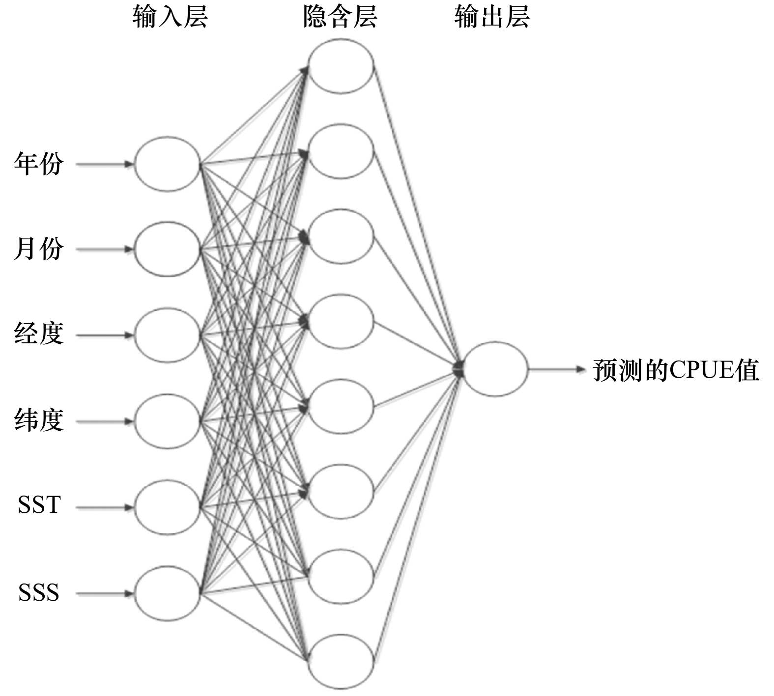
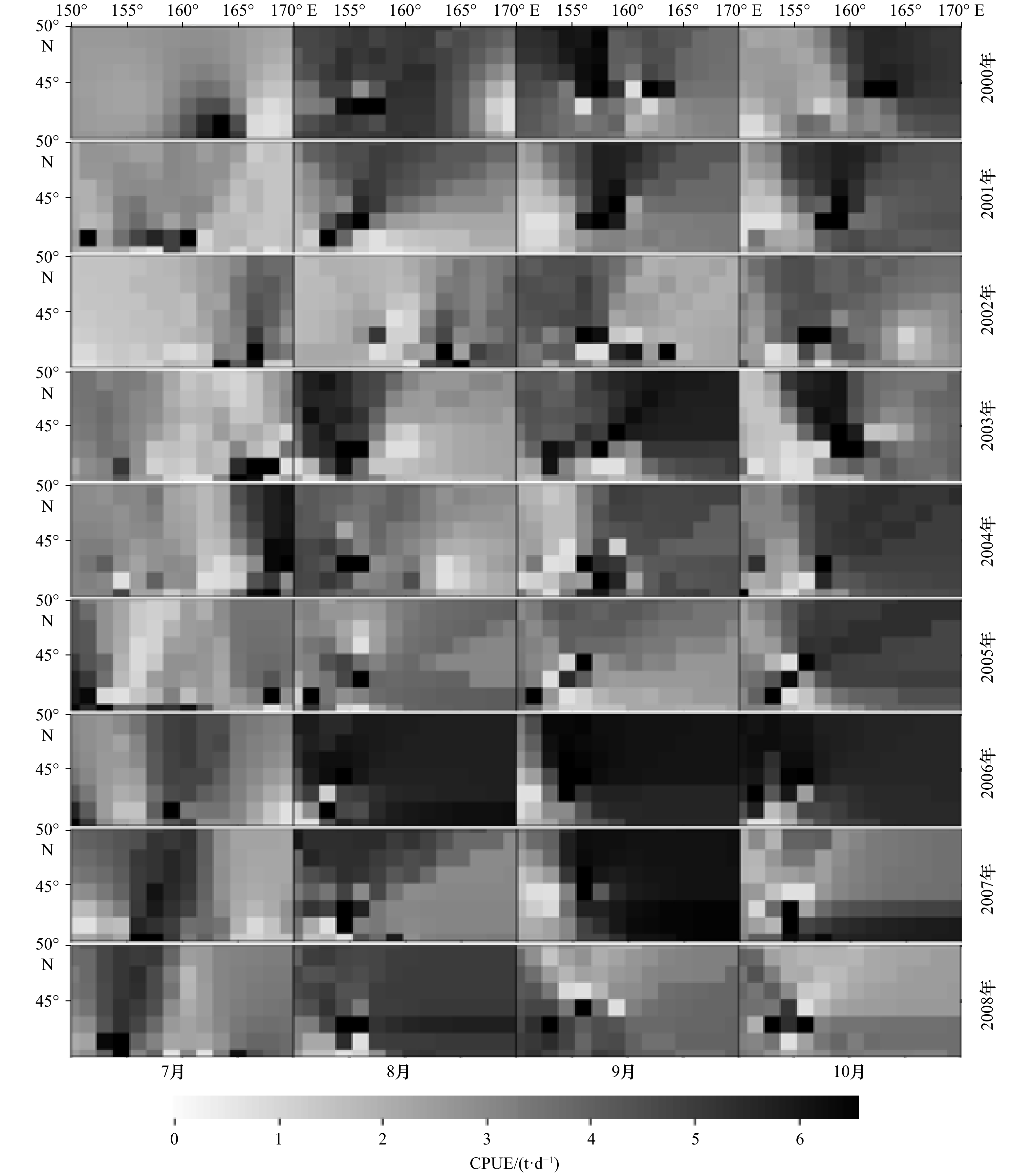
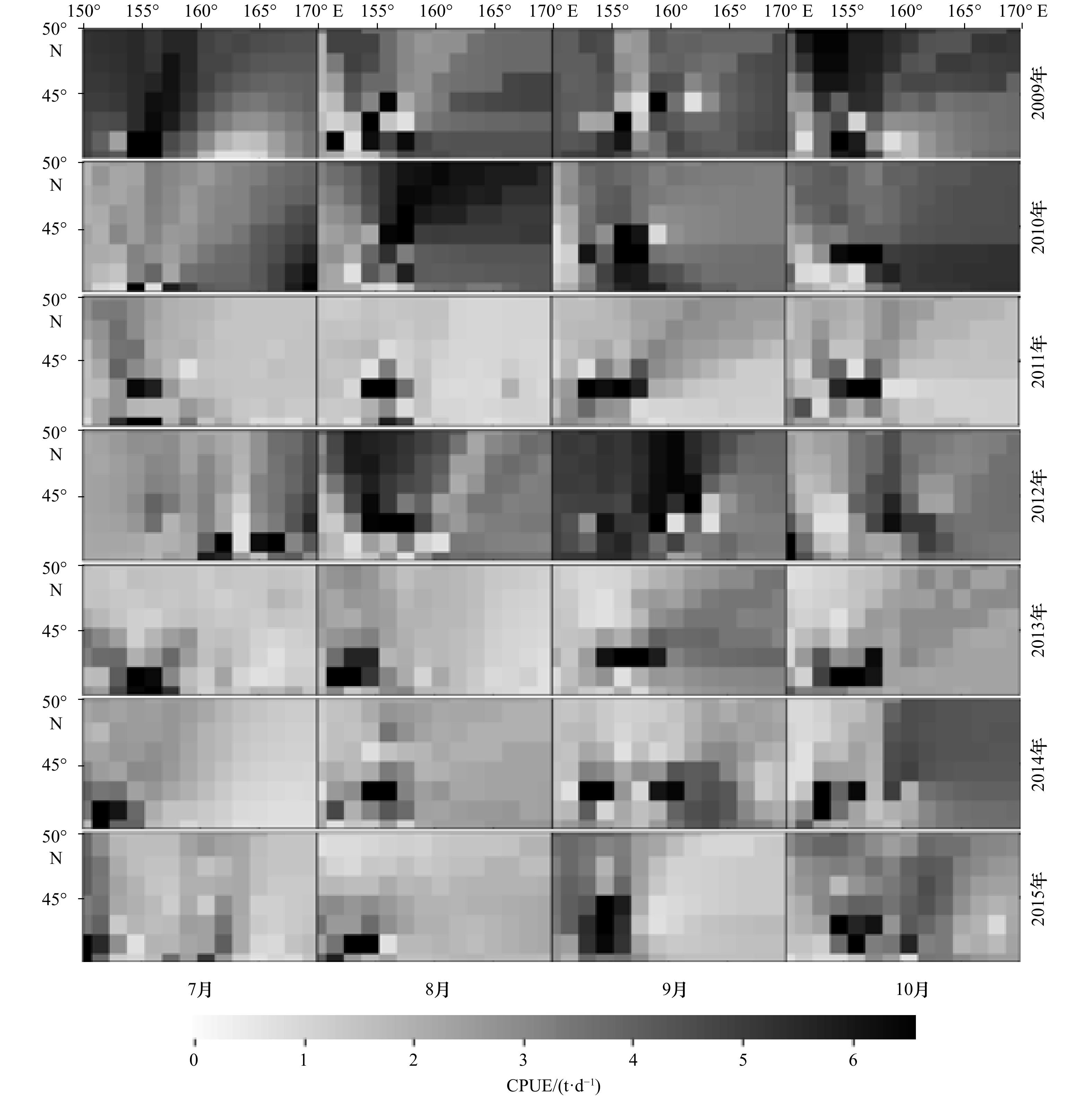
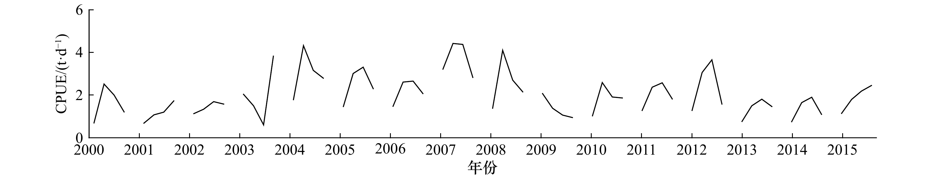
Ommastrephes bartramii is an economically important species for Chinese squid jigging fleet. Understanding the spatio-temporal distribution on fishing ground is crucial to the sustainable utilization of fish resources. The study constructed BP (back propagation) neural network models with different scenarios to speculate the dynamics of O. bartramii abundance based on fishery data in the months of July to October during 2000 to 2015. The model with year, month, longitude, latitude, sea surface temperature (SST), and sea surface salinity (SSS) as independent variables, 8 neurons in hidden layers, had the smallest mean square error, and thus selected as optimal model. The results showed that the significant fluctuation in CPUE between years, the local abundance was low and scattered in July and October, whereas was high and concentrated at 41.5°−43.5°N, 155°−160°E in August and September. Environmental factors, including SST and SSS affect the spatio-temporal distribution of local abundance, and should be considered in stock assessment and management.
Ommastrephes bartramii is an economically important species for Chinese squid jigging fleet. Understanding the spatio-temporal distribution on fishing ground is crucial to the sustainable utilization of fish resources. The study constructed BP (back propagation) neural network models with different scenarios to speculate the dynamics of O. bartramii abundance based on fishery data in the months of July to October during 2000 to 2015. The model with year, month, longitude, latitude, sea surface temperature (SST), and sea surface salinity (SSS) as independent variables, 8 neurons in hidden layers, had the smallest mean square error, and thus selected as optimal model. The results showed that the significant fluctuation in CPUE between years, the local abundance was low and scattered in July and October, whereas was high and concentrated at 41.5°−43.5°N, 155°−160°E in August and September. Environmental factors, including SST and SSS affect the spatio-temporal distribution of local abundance, and should be considered in stock assessment and management.
2021, 43(6): 90-97.
doi: 10.12284/hyxb2021102
Abstract:
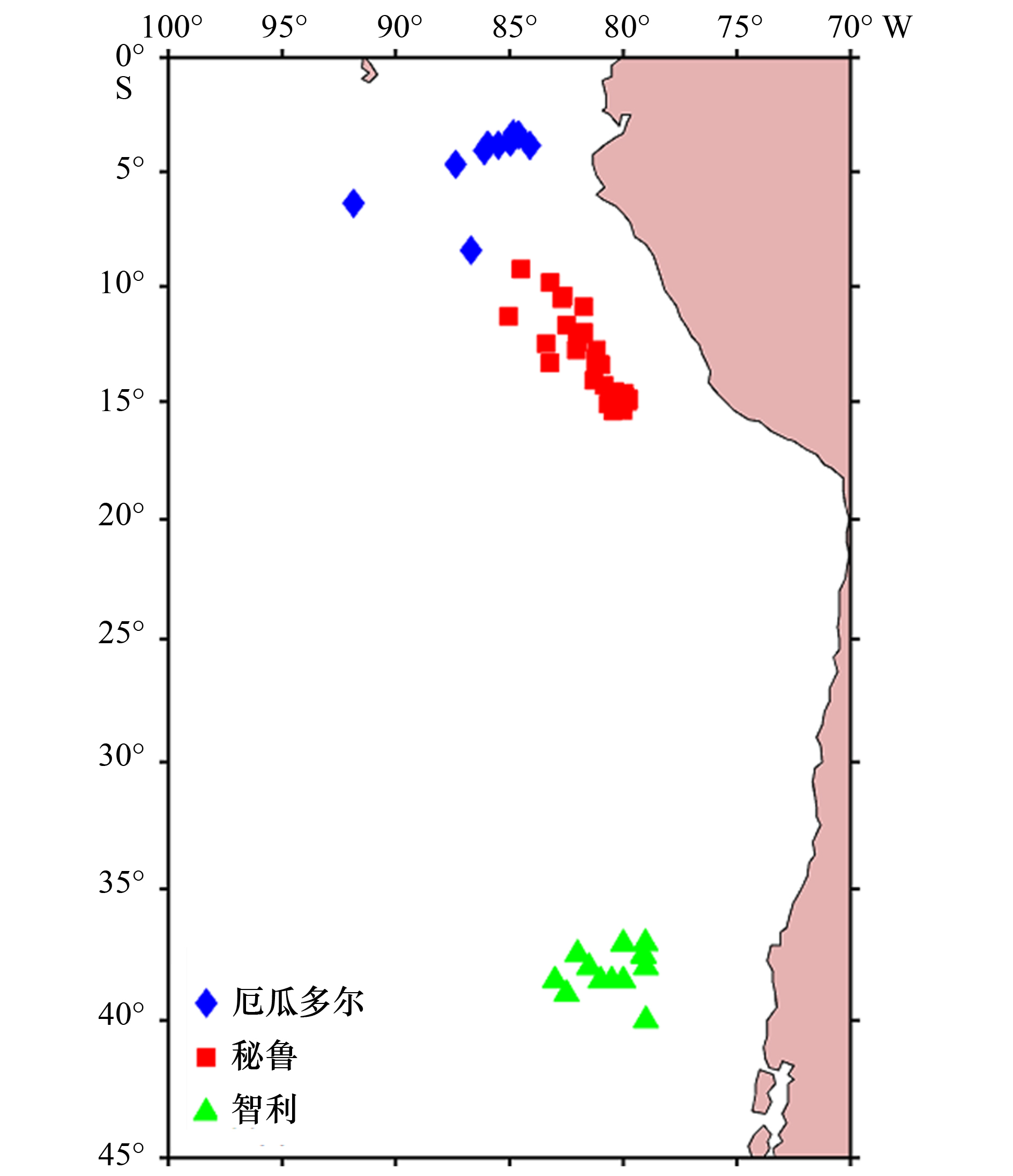
Samples of Jumbo flying squid (Dosidicus gigas) were collected from Chinese squid jigging vessels in the high seas of Ecuador, Peru and Chile in the southeast Pacific Ocean in 2015 and 2017. The trace elements in the eye lenses of D. gigas were measured to study the geographical differences and their relationship with sea surface temperature. The results showed that elements such as Mg25, Ni60, Cu63, Sr88 and Ba137 in the peripheral part of eye lenses of D. gigas in the high seas of Ecuador, Peru and Chile were significant difference, while there were no significant differences between each two sea areas in the elements of Na23, Al27, Si29, P31, Ca43, Mn55, Zn66 and Pb. Except for Sr88, Ba137, Fe57 and Ni60, which showed significantly linear negative correlations with SST (p<0.05), there were no significant correlations with SST in the other elements (p>0.05). Sr88, Ba137, Fe57 and Ni60 could be regarded as indicator elements of the ambient temperature of D. gigas, and Ba137 could also be regarded as indicator element of the water depth and upwelling. Consequently, trace elements in eye lenses could be used to reconstruct the habitat environment of cephalopod.
Samples of Jumbo flying squid (Dosidicus gigas) were collected from Chinese squid jigging vessels in the high seas of Ecuador, Peru and Chile in the southeast Pacific Ocean in 2015 and 2017. The trace elements in the eye lenses of D. gigas were measured to study the geographical differences and their relationship with sea surface temperature. The results showed that elements such as Mg25, Ni60, Cu63, Sr88 and Ba137 in the peripheral part of eye lenses of D. gigas in the high seas of Ecuador, Peru and Chile were significant difference, while there were no significant differences between each two sea areas in the elements of Na23, Al27, Si29, P31, Ca43, Mn55, Zn66 and Pb. Except for Sr88, Ba137, Fe57 and Ni60, which showed significantly linear negative correlations with SST (p<0.05), there were no significant correlations with SST in the other elements (p>0.05). Sr88, Ba137, Fe57 and Ni60 could be regarded as indicator elements of the ambient temperature of D. gigas, and Ba137 could also be regarded as indicator element of the water depth and upwelling. Consequently, trace elements in eye lenses could be used to reconstruct the habitat environment of cephalopod.


2021, 43(6): 98-107.
doi: 10.12284/hyxb2021068
Abstract:
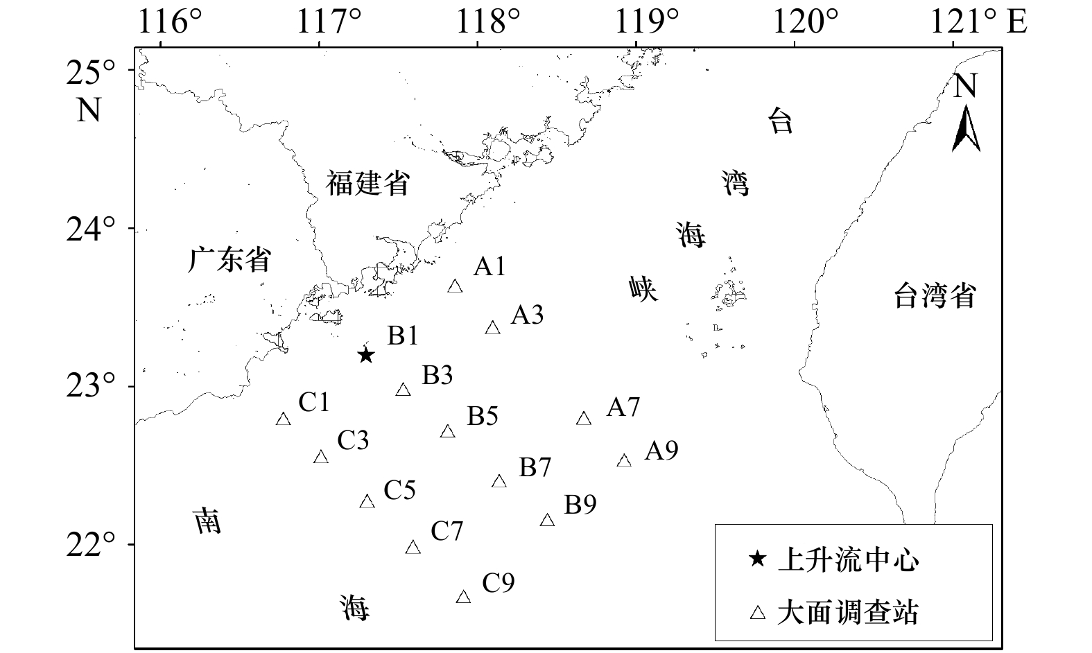
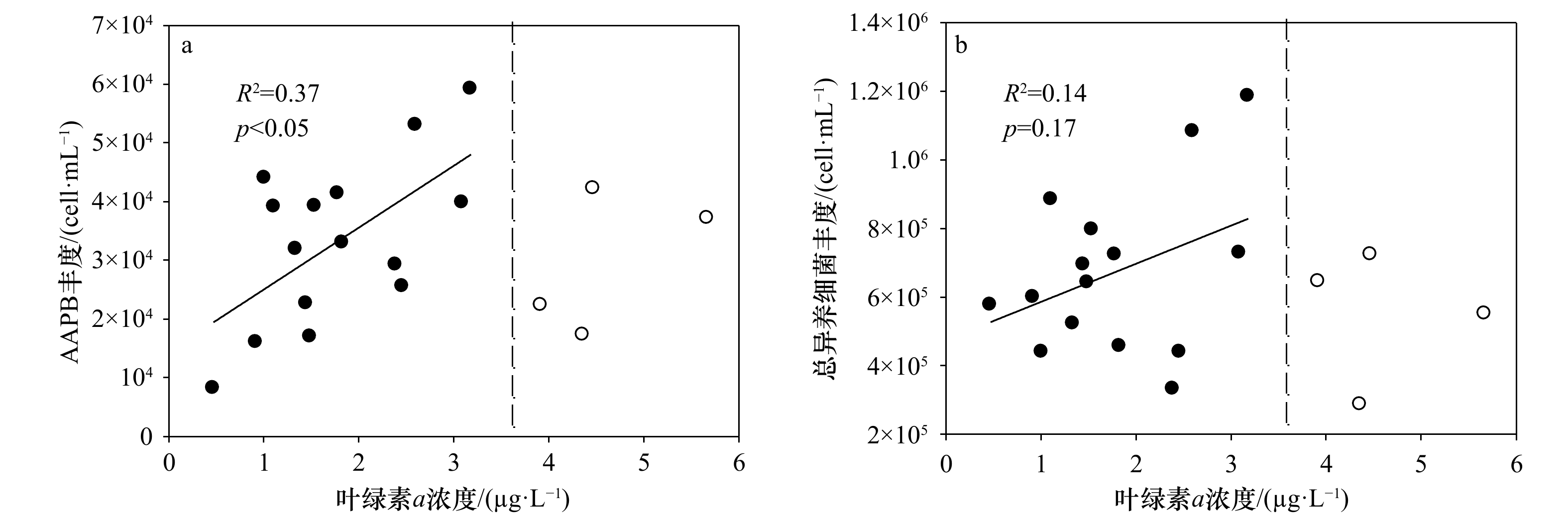
There is little information about the relationship between aerobic anoxygenic photoheterotrophic bacteria (AAPB) and upwelling. In this work, the response of AAPB to upwelling in the southern Taiwan Strait was examined, using the “Time-series observation-based cyanobacteria-calibrated InfraRed Epifluorescence Microscopy, TIREM”. The results showed that in the initial stage of upwelling, the abundances of AAPB and total heterotrophic bacteria were low; with the development, their abundances both increased and reached the highest value at the mature stage of upwelling; notably, when the upwelling declined, they began to decrease. During the developmental process of upwelling, AAPB abundance was positively correlated with chlorophyll a concentration in a certain range, and limited by low phosphorus concentration, while total heterotrophic bacteria abundance was positively correlated with nitrogen, phosphorus and silicon nutrients concentration, suggesting that dissolved organic carbon released by phytoplankton and phosphorus limitation might play a more direct and important role in AAPB, while nutrients probably acted as an important role in the response of total heterotrophic bacteria to upwelling. This study will help to better understand the unique role of AAPB in the biogeochemical cycle of carbon and other biogenic elements.
There is little information about the relationship between aerobic anoxygenic photoheterotrophic bacteria (AAPB) and upwelling. In this work, the response of AAPB to upwelling in the southern Taiwan Strait was examined, using the “Time-series observation-based cyanobacteria-calibrated InfraRed Epifluorescence Microscopy, TIREM”. The results showed that in the initial stage of upwelling, the abundances of AAPB and total heterotrophic bacteria were low; with the development, their abundances both increased and reached the highest value at the mature stage of upwelling; notably, when the upwelling declined, they began to decrease. During the developmental process of upwelling, AAPB abundance was positively correlated with chlorophyll a concentration in a certain range, and limited by low phosphorus concentration, while total heterotrophic bacteria abundance was positively correlated with nitrogen, phosphorus and silicon nutrients concentration, suggesting that dissolved organic carbon released by phytoplankton and phosphorus limitation might play a more direct and important role in AAPB, while nutrients probably acted as an important role in the response of total heterotrophic bacteria to upwelling. This study will help to better understand the unique role of AAPB in the biogeochemical cycle of carbon and other biogenic elements.


2021, 43(6): 108-117.
doi: 10.12284/hyxb2021110
Abstract:
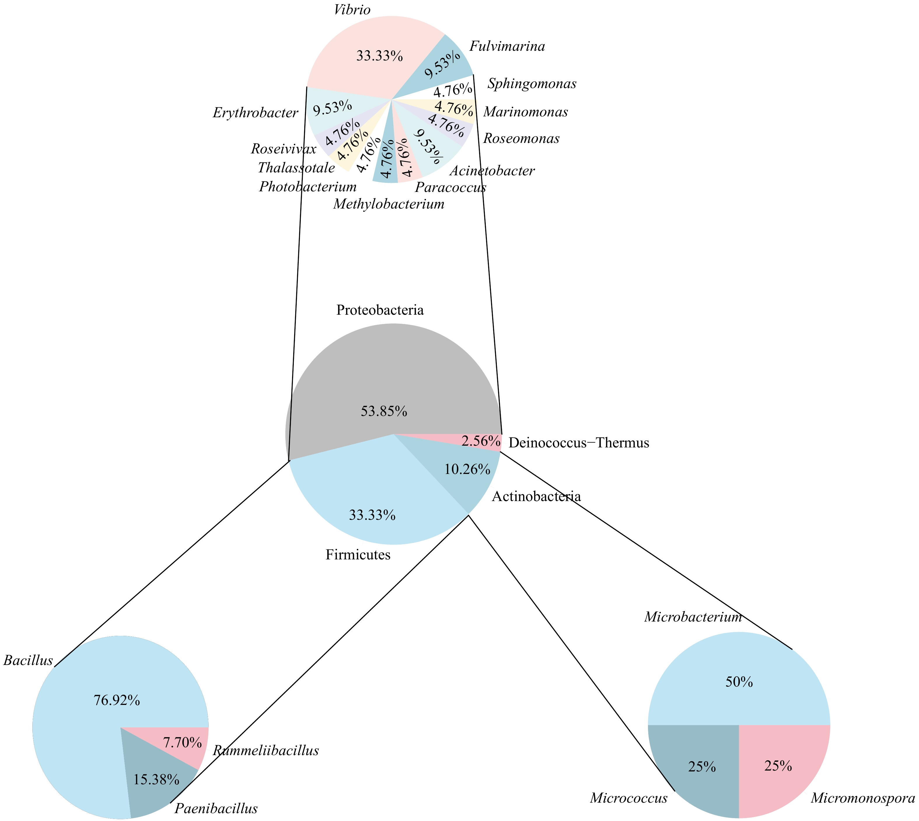
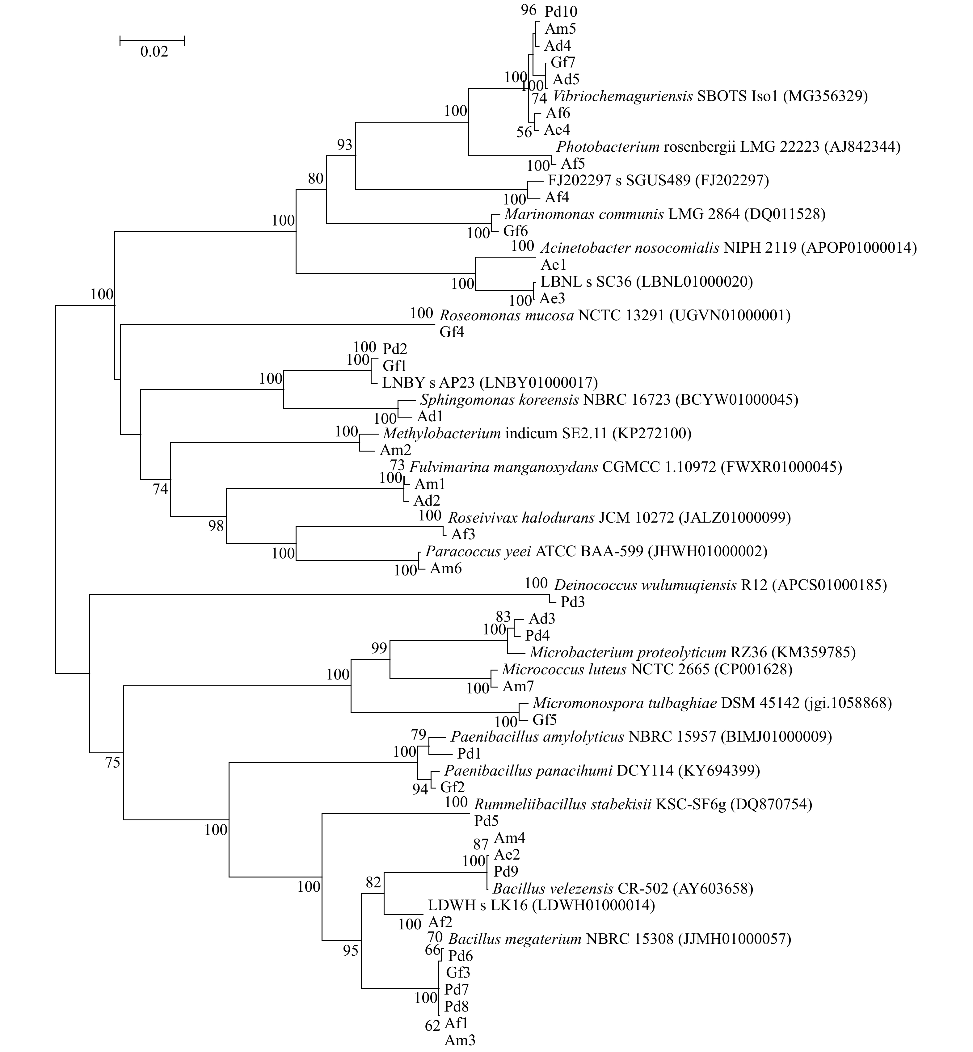
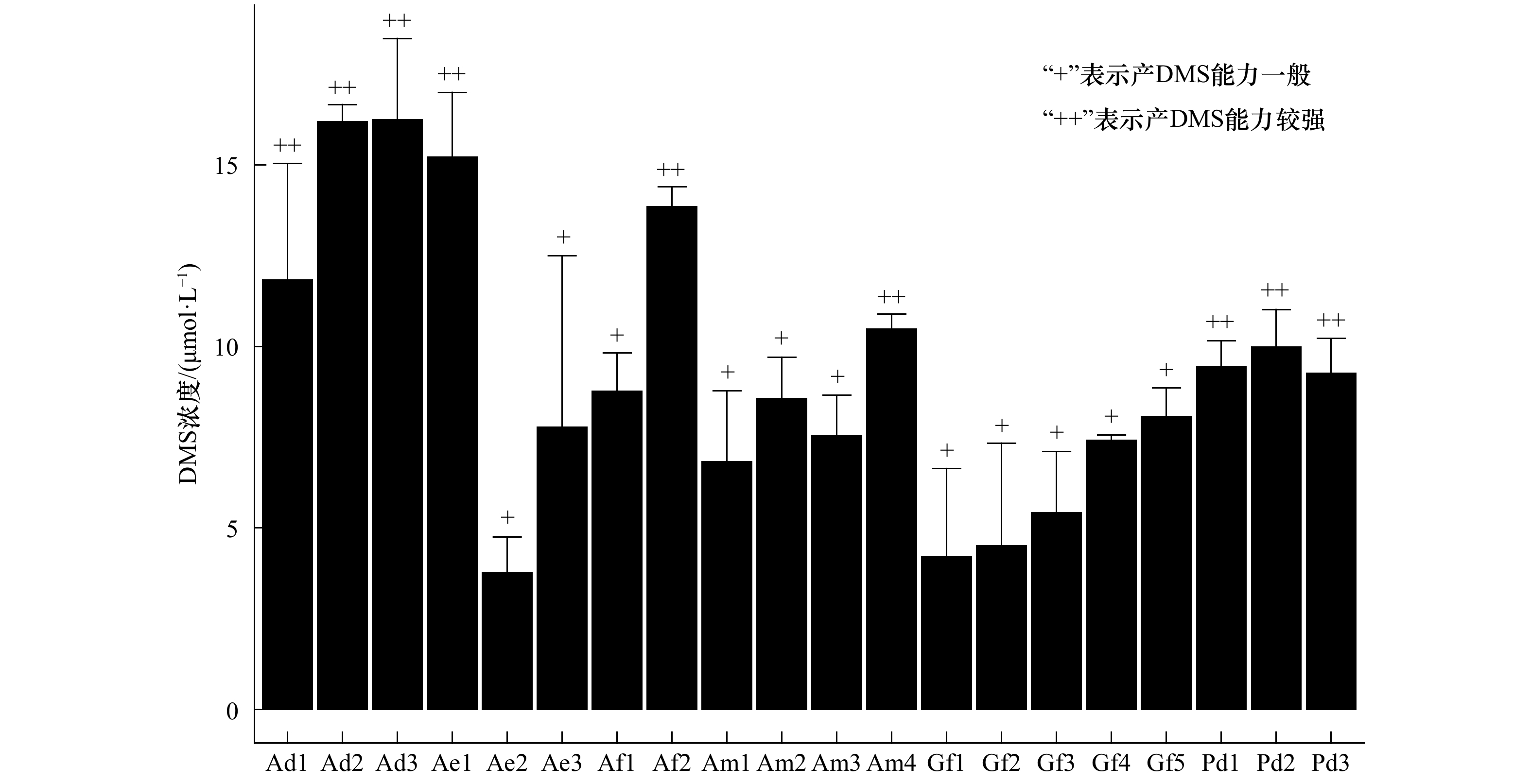
Dimethylsulfoniopropionate (DMSP) is one of the most abundant organic sulfur molecules on earth, and plays an important role in global sulfur cycle and climate regulation. DMSP is the principal precursor of dimethyl sulfide (DMS), which can be degraded through many ways in the ocean, and microbial degradation is one of the most important ways. Coral reef is one of the major sources of marine DMS, and coral-associated DMSP degrading bacteria play an important role in the process of DMS production. In the present study, 39 strains of DMSP degrading bacteria were isolated from six reef building corals, including Acropora millepora, Acropora formosa, Acropora echinata, Acropora digitifera, Pocillopora damicornis, and Galaxea fascicularis. The phylogenetic analysis of DMSP degrading bacteria was performed based on 16S rRNA gene sequence, 39 strains of DMSP degrading bacteria belonged to 4 phyla, 6 classes, and 19 genera, the dominant genus was Bacillus. The DMS production efficiency of DMSP degrading bacteria were analyzed by GC-FPD detection of DMSP products, the results showed that 9 strains had the ability of high DMS production. The probiotic effects of bacteria with high DMS production on corals in response to climate warming need to be further studied.
Dimethylsulfoniopropionate (DMSP) is one of the most abundant organic sulfur molecules on earth, and plays an important role in global sulfur cycle and climate regulation. DMSP is the principal precursor of dimethyl sulfide (DMS), which can be degraded through many ways in the ocean, and microbial degradation is one of the most important ways. Coral reef is one of the major sources of marine DMS, and coral-associated DMSP degrading bacteria play an important role in the process of DMS production. In the present study, 39 strains of DMSP degrading bacteria were isolated from six reef building corals, including Acropora millepora, Acropora formosa, Acropora echinata, Acropora digitifera, Pocillopora damicornis, and Galaxea fascicularis. The phylogenetic analysis of DMSP degrading bacteria was performed based on 16S rRNA gene sequence, 39 strains of DMSP degrading bacteria belonged to 4 phyla, 6 classes, and 19 genera, the dominant genus was Bacillus. The DMS production efficiency of DMSP degrading bacteria were analyzed by GC-FPD detection of DMSP products, the results showed that 9 strains had the ability of high DMS production. The probiotic effects of bacteria with high DMS production on corals in response to climate warming need to be further studied.
2021, 43(6): 118-128.
doi: 10.12284/hyxb2021092
Abstract:
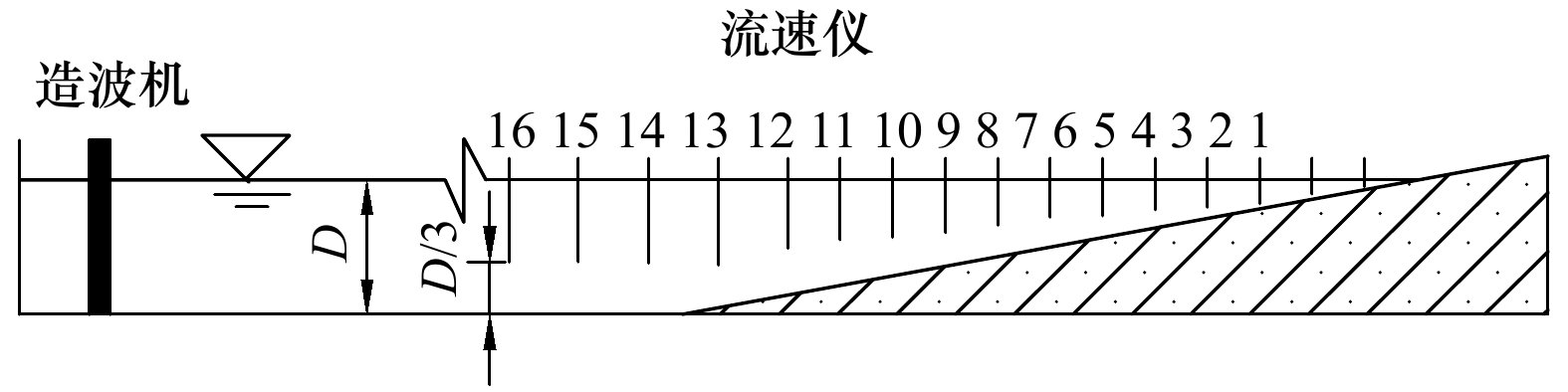
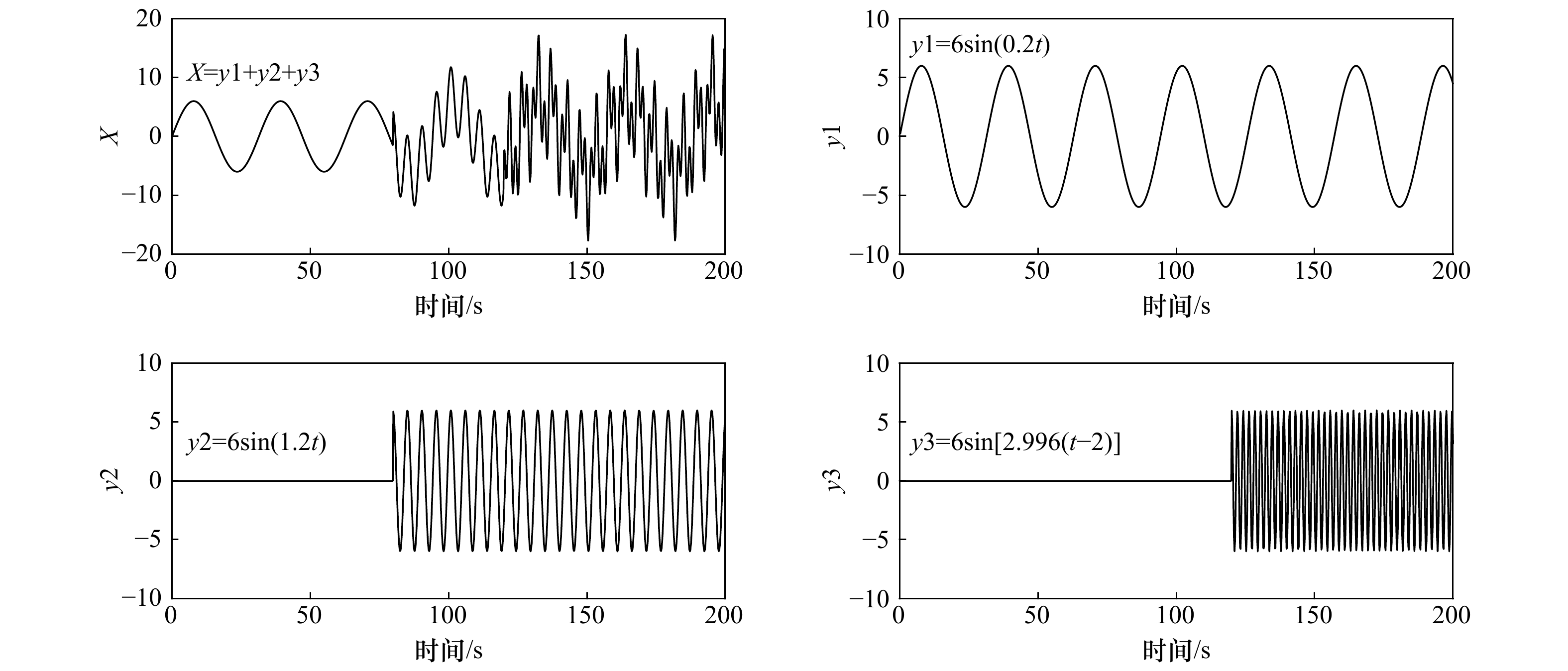
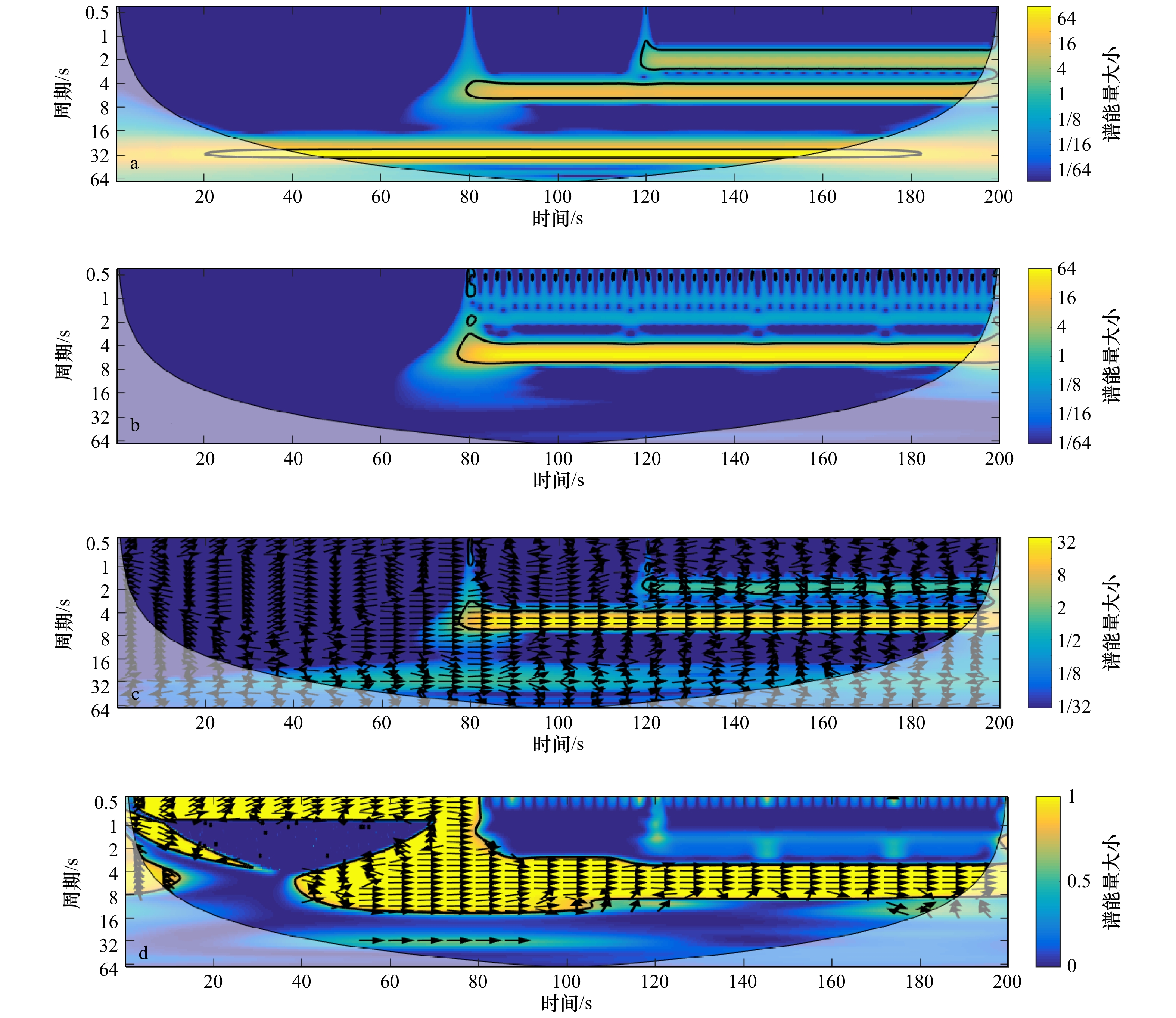
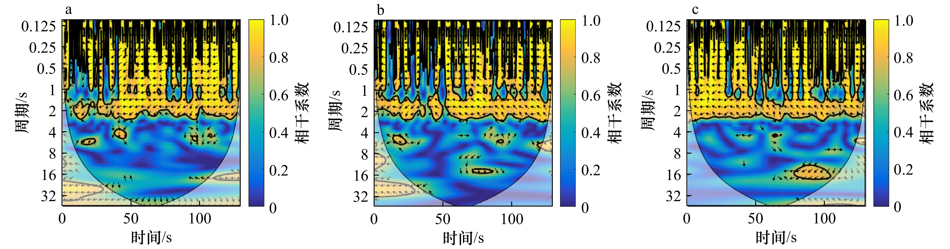
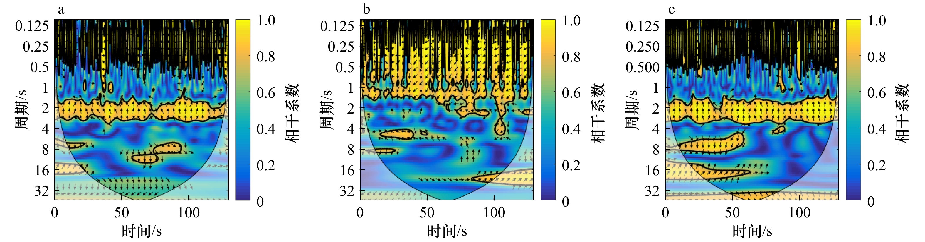
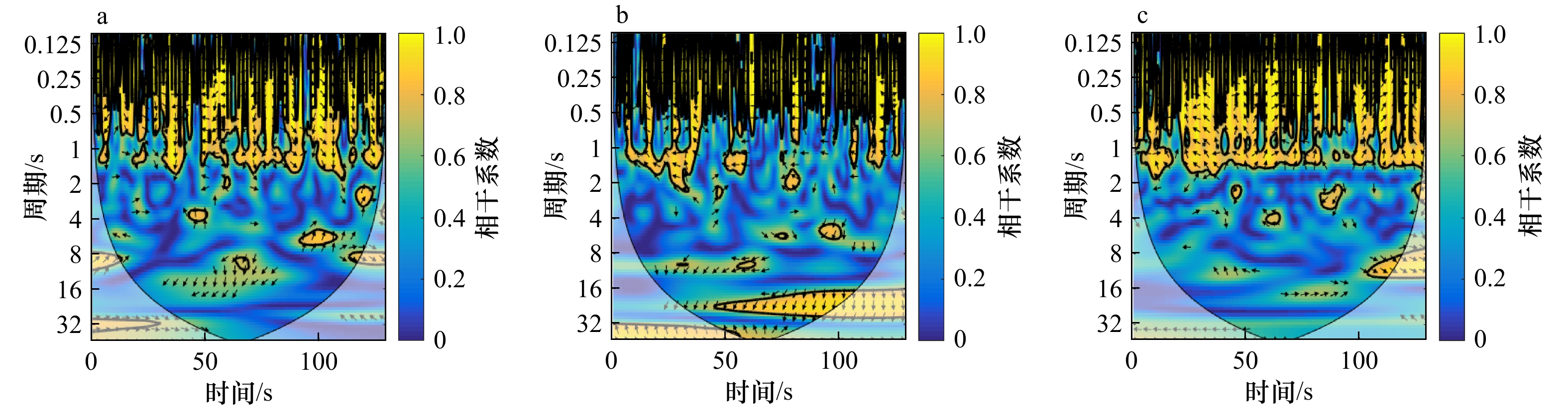
The instabilities of longshore currents are the far infragravity band waves. The study of its propagation characteristics will help us to understand its influence on the evolution of coastal beach and the transport and migration of pollutants, fish eggs and other organisms. Based on the wavelet coherence spectrum, this paper analyzes the propagation characteristics of the unsteady motion under regular and random waves, and discusses the influence of the wave height, period and slope on it. The results show that the irregular wave is easier to induce the unsteady motion, and the positive or negative phase difference of the unsteady motion is about 30° in the case of irregular waves, which is similar to the incident angle of waves; with the increase of the incident wave height, nonlinear effects become stronger and the period range of the unsteady motion will be wider, that is to say, it is easier to induce the unsteady motion; the incident wave period has a little effect on the propagation; the steeper the slope is, the more likely it is to induce the instabilities of longshore currents.
The instabilities of longshore currents are the far infragravity band waves. The study of its propagation characteristics will help us to understand its influence on the evolution of coastal beach and the transport and migration of pollutants, fish eggs and other organisms. Based on the wavelet coherence spectrum, this paper analyzes the propagation characteristics of the unsteady motion under regular and random waves, and discusses the influence of the wave height, period and slope on it. The results show that the irregular wave is easier to induce the unsteady motion, and the positive or negative phase difference of the unsteady motion is about 30° in the case of irregular waves, which is similar to the incident angle of waves; with the increase of the incident wave height, nonlinear effects become stronger and the period range of the unsteady motion will be wider, that is to say, it is easier to induce the unsteady motion; the incident wave period has a little effect on the propagation; the steeper the slope is, the more likely it is to induce the instabilities of longshore currents.


2021, 43(6): 129-138.
doi: 10.12284/hyxb2021100
Abstract:
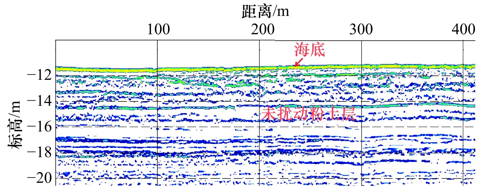
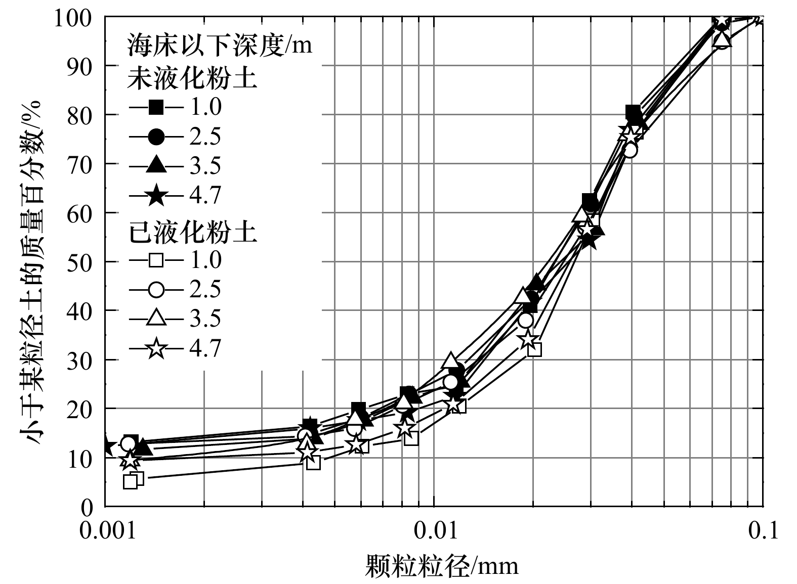
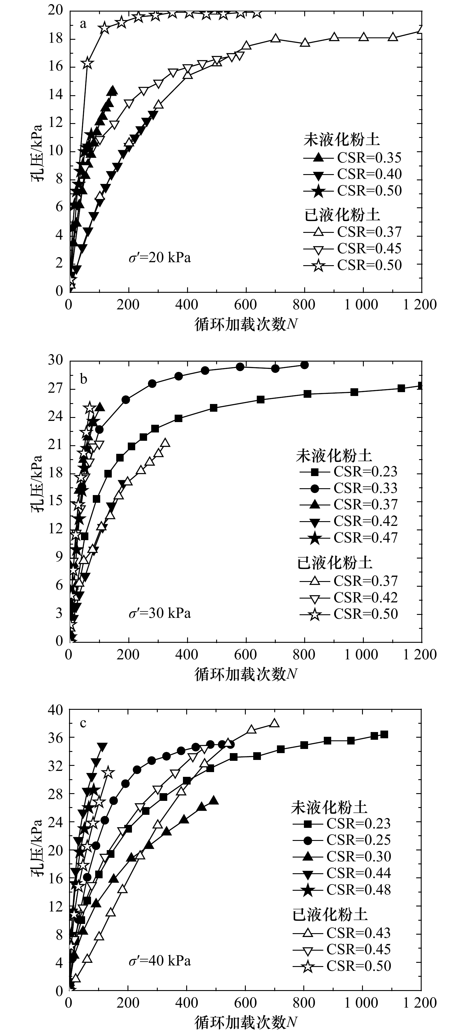
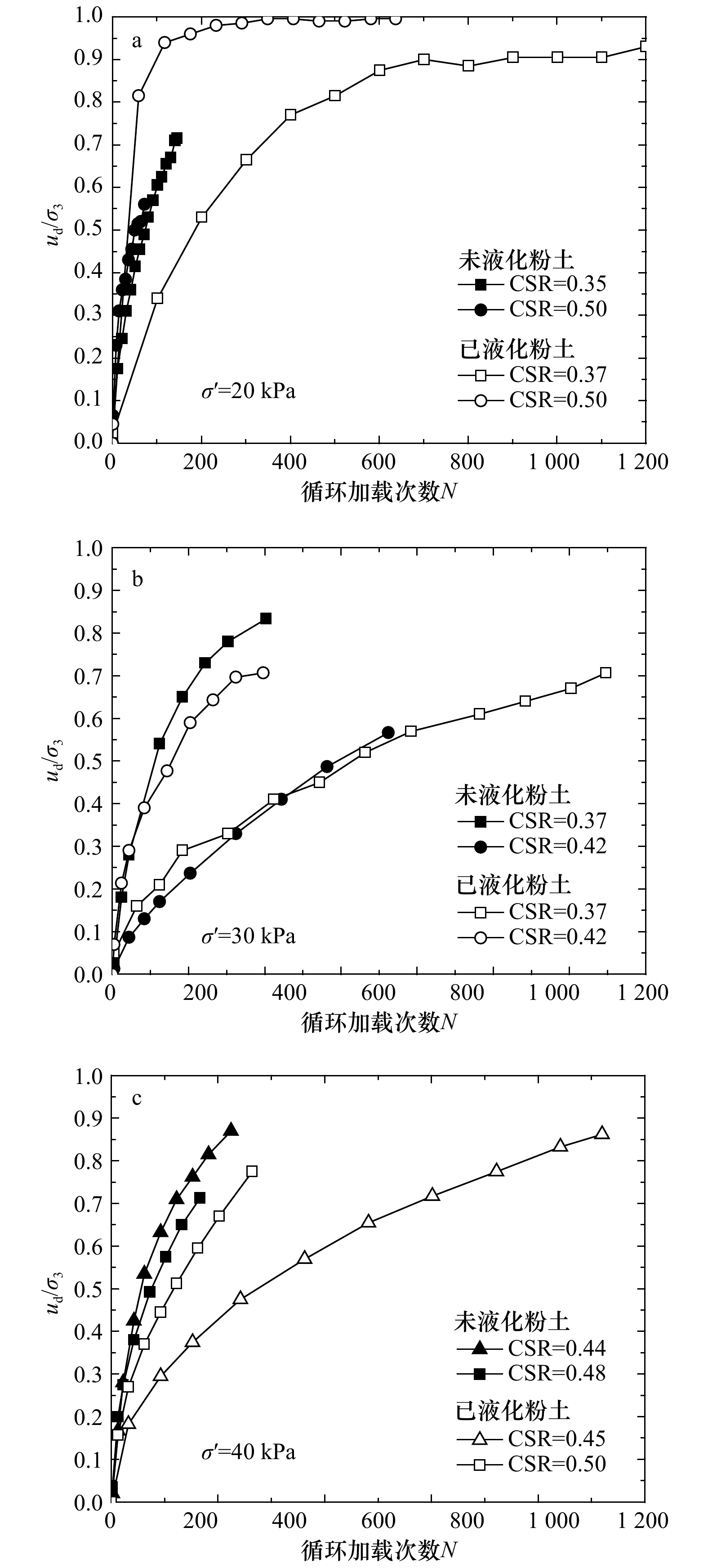
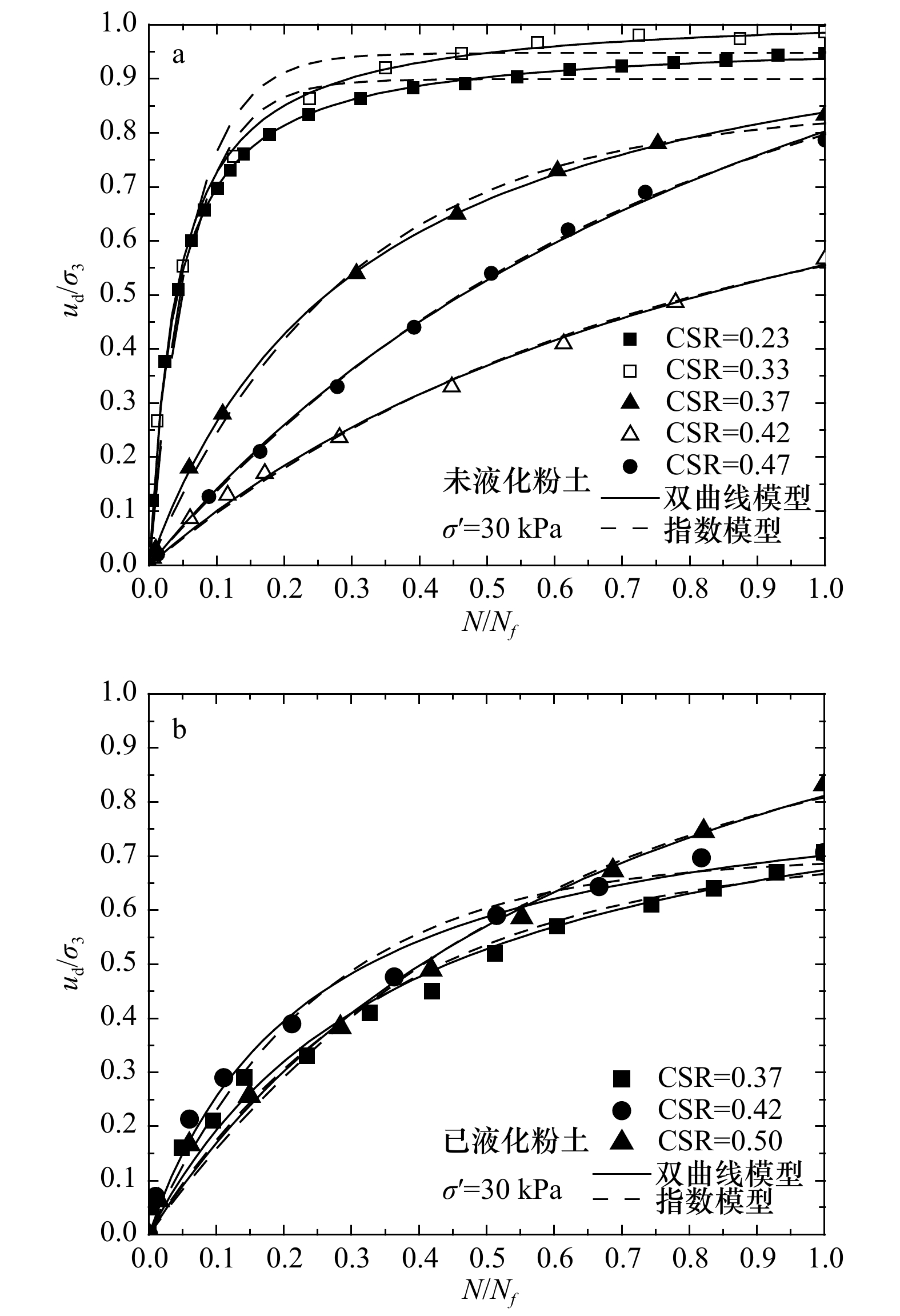
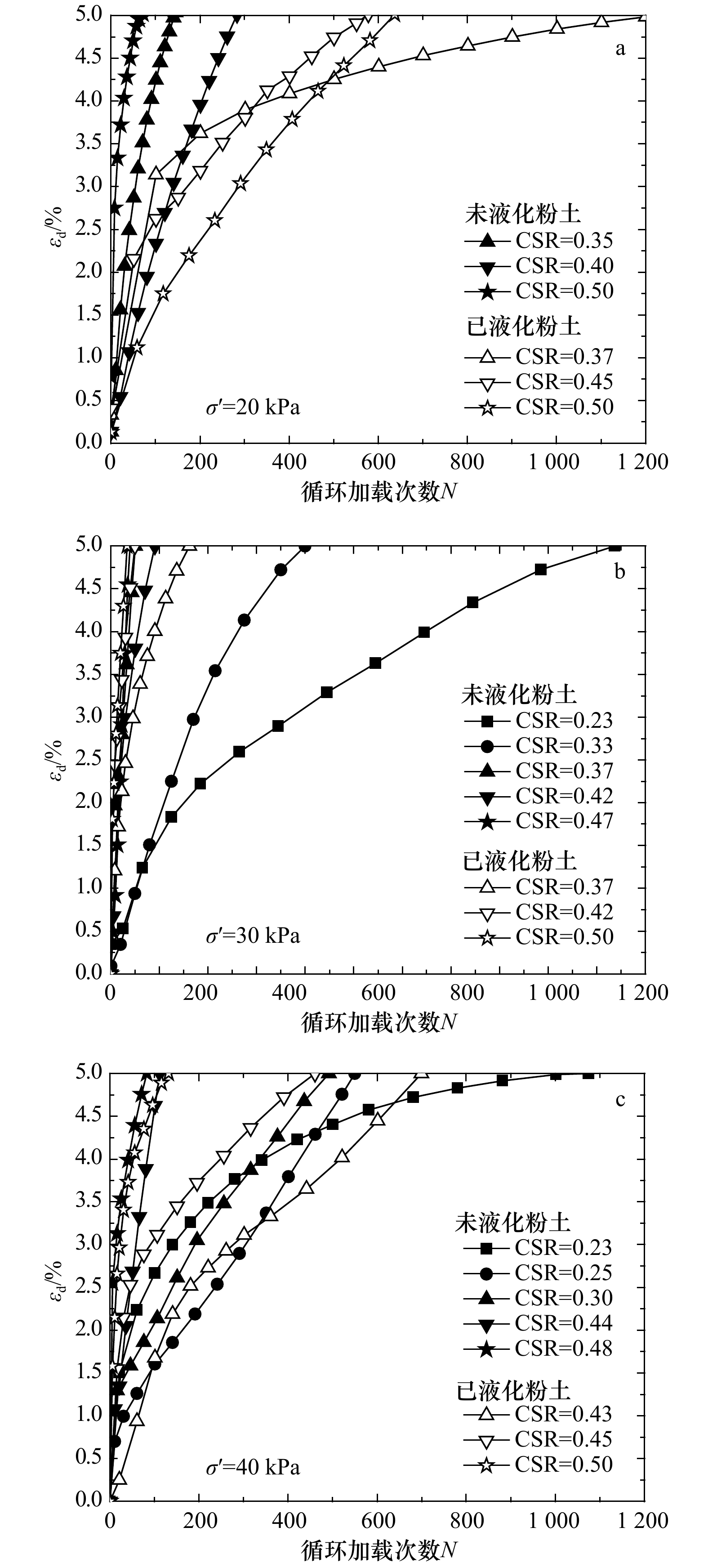
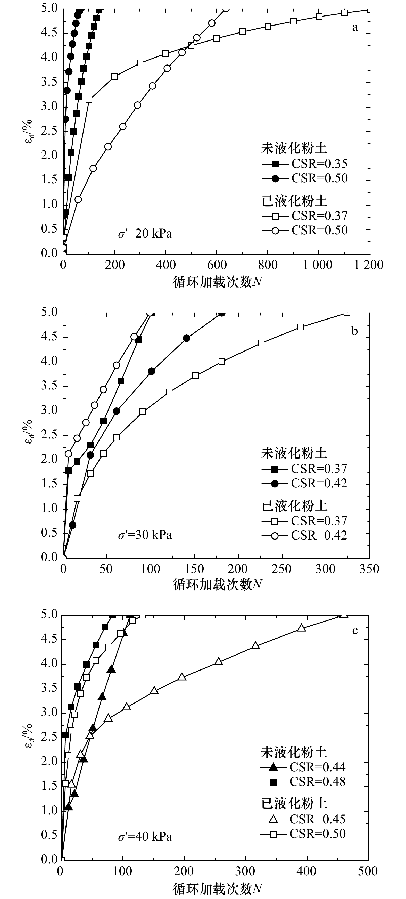
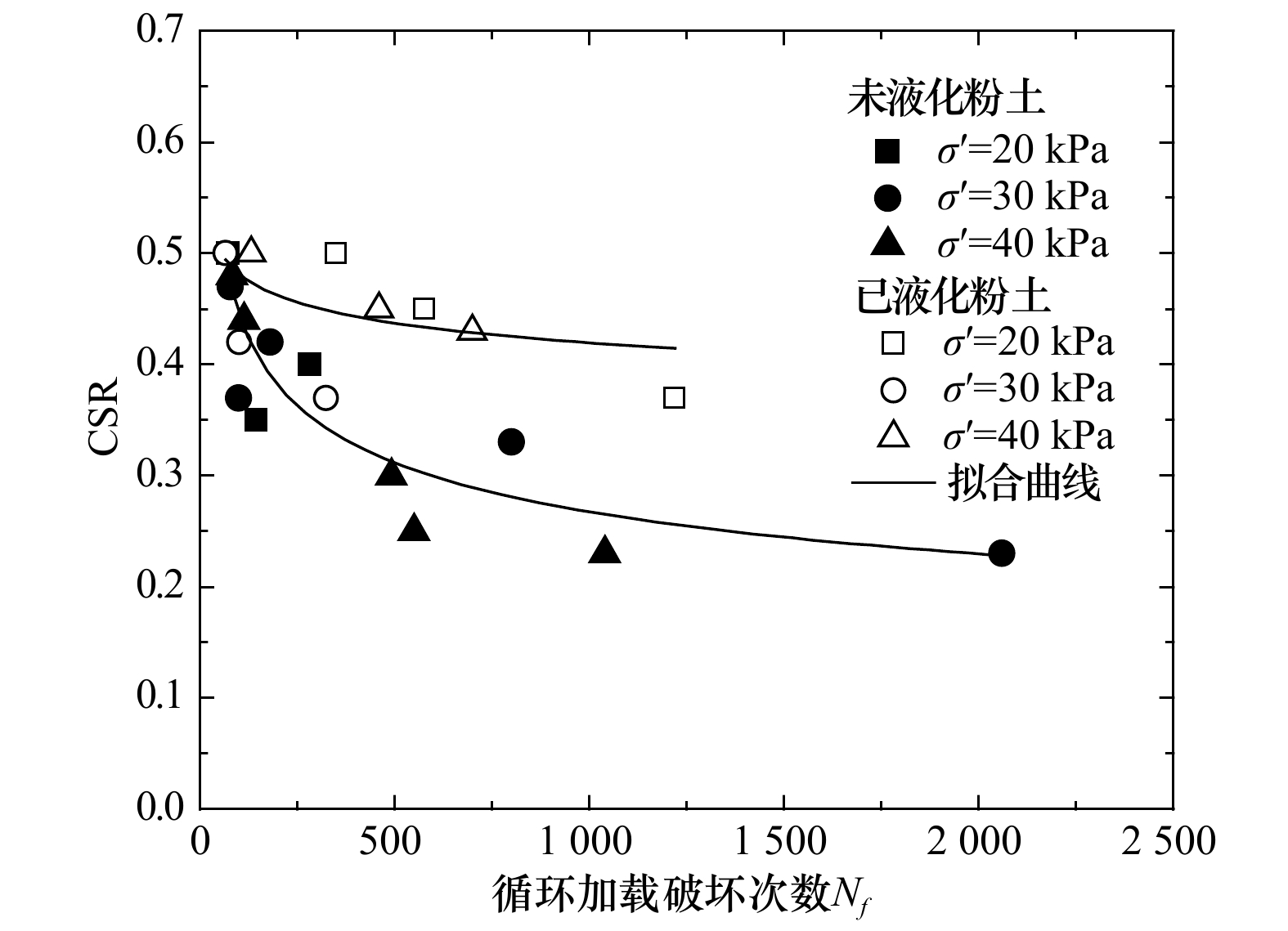
As a common submarine geological disaster, wave-induced seabed liquefaction seriously threatens the safety of subsea engineering facilities in the Huanghe River Delta. The structure, physical and mechanical properties of seabed soil after wave-induced liquefaction all have changed, so it has important theoretical significance and practical value to study on the evaluation of potential possibility of re-liquefaction of seabed soil after previous liquefaction. In this paper, a series of cyclic triaxial liquefaction tests were conducted on core samples collected from submarine non-liquefied and liquefied zone in the Huanghe River Delta, respectively. The differences between non-liquefied and liquefied seabed soil in the developing trends of pore pressure and axial dynamic strain with cycles were analyzed and discussed, and the corresponding liquefaction potentials were also comparatively evaluated. The test results show that compared to pore pressure, the strain standard is more suitable to evaluate the liquefaction potential of the seabed silt in the Huanghe River Delta. The pore pressure and dynamic axial strain development characteristics indicate that the re-liquefaction resistance of the liquefied seabed silt is improved to some extent compared with the non-liquefied silt. Furthermore, the correlations between the normalized pore pressure ratio ud/σ3 and the normalized cycle ratio N/Nf could be described quantitatively by the hyperbolic or exponential functions for liquefied and non-liquefied seabed silts. Finally, the critical cyclic stress ratio for the non-liquefied seabed silt is around 0.20 compared to 0.35 for the liquefied one in the Huanghe River Delta. The research findings will contribute to deepening the understanding of the wave-induced liquefaction mechanism of seabed silt, and also provide an example reference for the study of the mechanical properties of soil subjected to previous cyclic stress history.
As a common submarine geological disaster, wave-induced seabed liquefaction seriously threatens the safety of subsea engineering facilities in the Huanghe River Delta. The structure, physical and mechanical properties of seabed soil after wave-induced liquefaction all have changed, so it has important theoretical significance and practical value to study on the evaluation of potential possibility of re-liquefaction of seabed soil after previous liquefaction. In this paper, a series of cyclic triaxial liquefaction tests were conducted on core samples collected from submarine non-liquefied and liquefied zone in the Huanghe River Delta, respectively. The differences between non-liquefied and liquefied seabed soil in the developing trends of pore pressure and axial dynamic strain with cycles were analyzed and discussed, and the corresponding liquefaction potentials were also comparatively evaluated. The test results show that compared to pore pressure, the strain standard is more suitable to evaluate the liquefaction potential of the seabed silt in the Huanghe River Delta. The pore pressure and dynamic axial strain development characteristics indicate that the re-liquefaction resistance of the liquefied seabed silt is improved to some extent compared with the non-liquefied silt. Furthermore, the correlations between the normalized pore pressure ratio ud/σ3 and the normalized cycle ratio N/Nf could be described quantitatively by the hyperbolic or exponential functions for liquefied and non-liquefied seabed silts. Finally, the critical cyclic stress ratio for the non-liquefied seabed silt is around 0.20 compared to 0.35 for the liquefied one in the Huanghe River Delta. The research findings will contribute to deepening the understanding of the wave-induced liquefaction mechanism of seabed silt, and also provide an example reference for the study of the mechanical properties of soil subjected to previous cyclic stress history.
2021, 43(6): 139-144.
doi: 10.12284/hyxb2021074
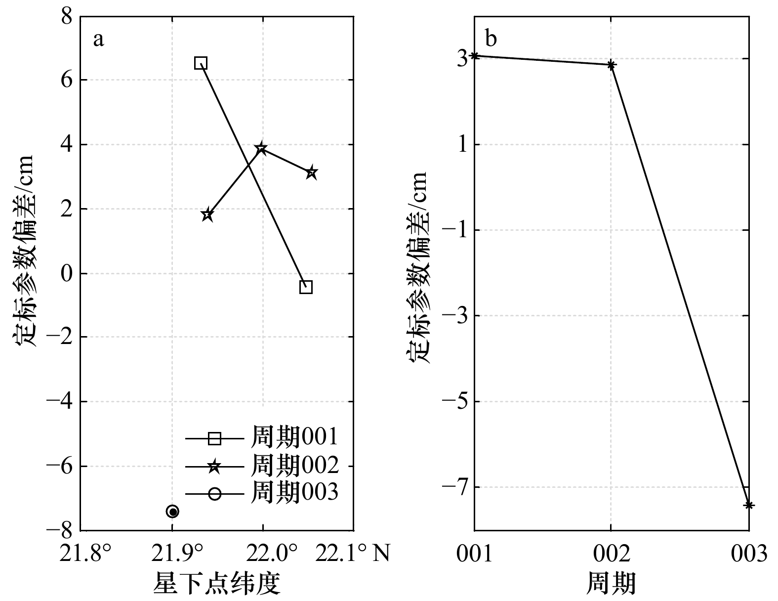
Abstract:
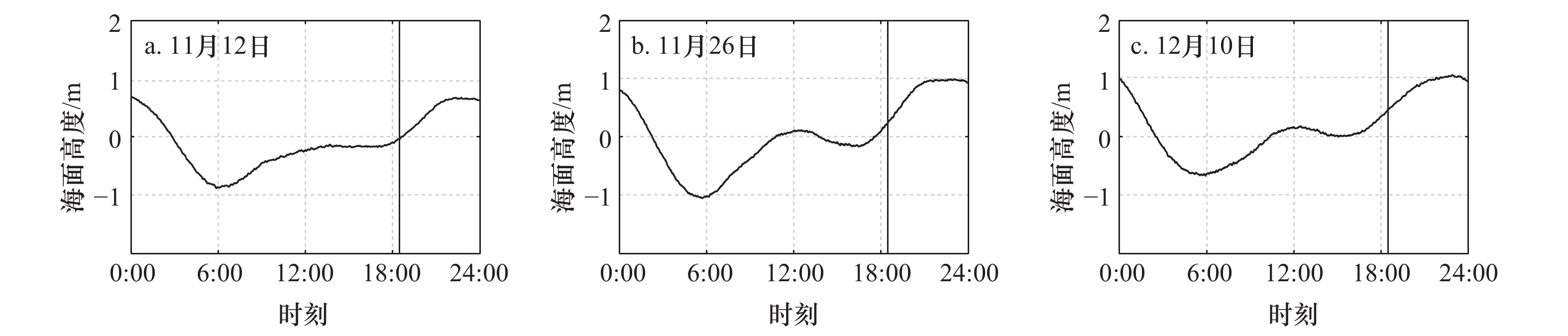
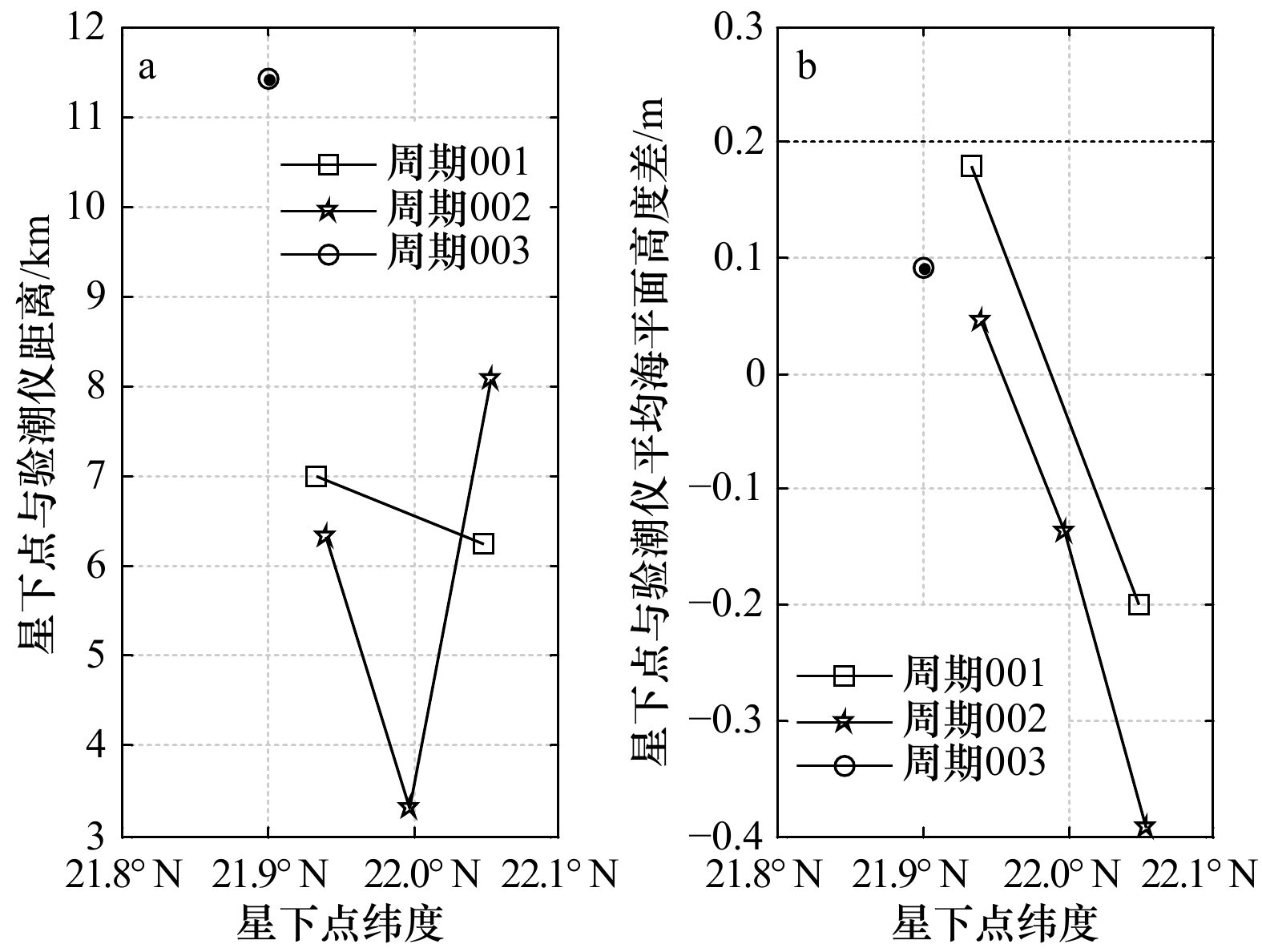
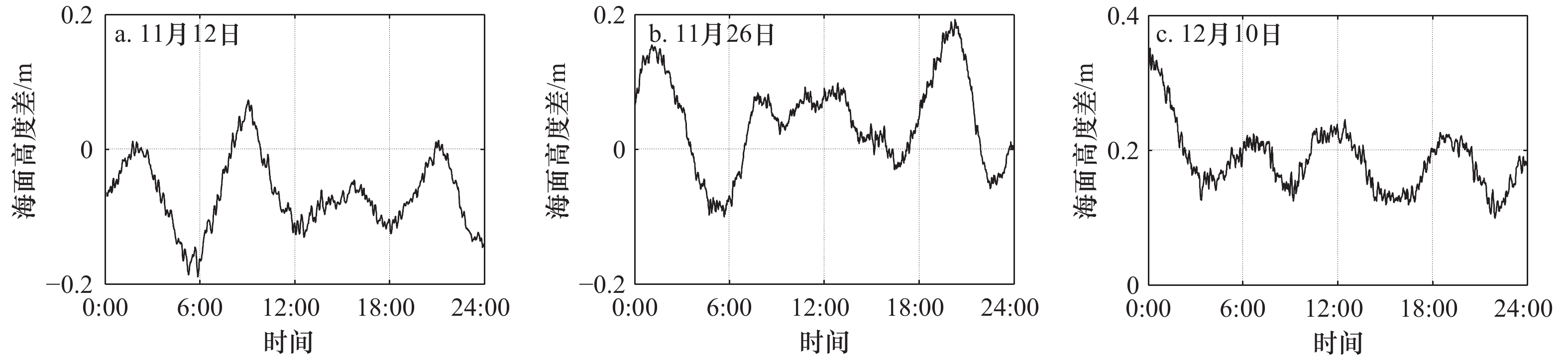
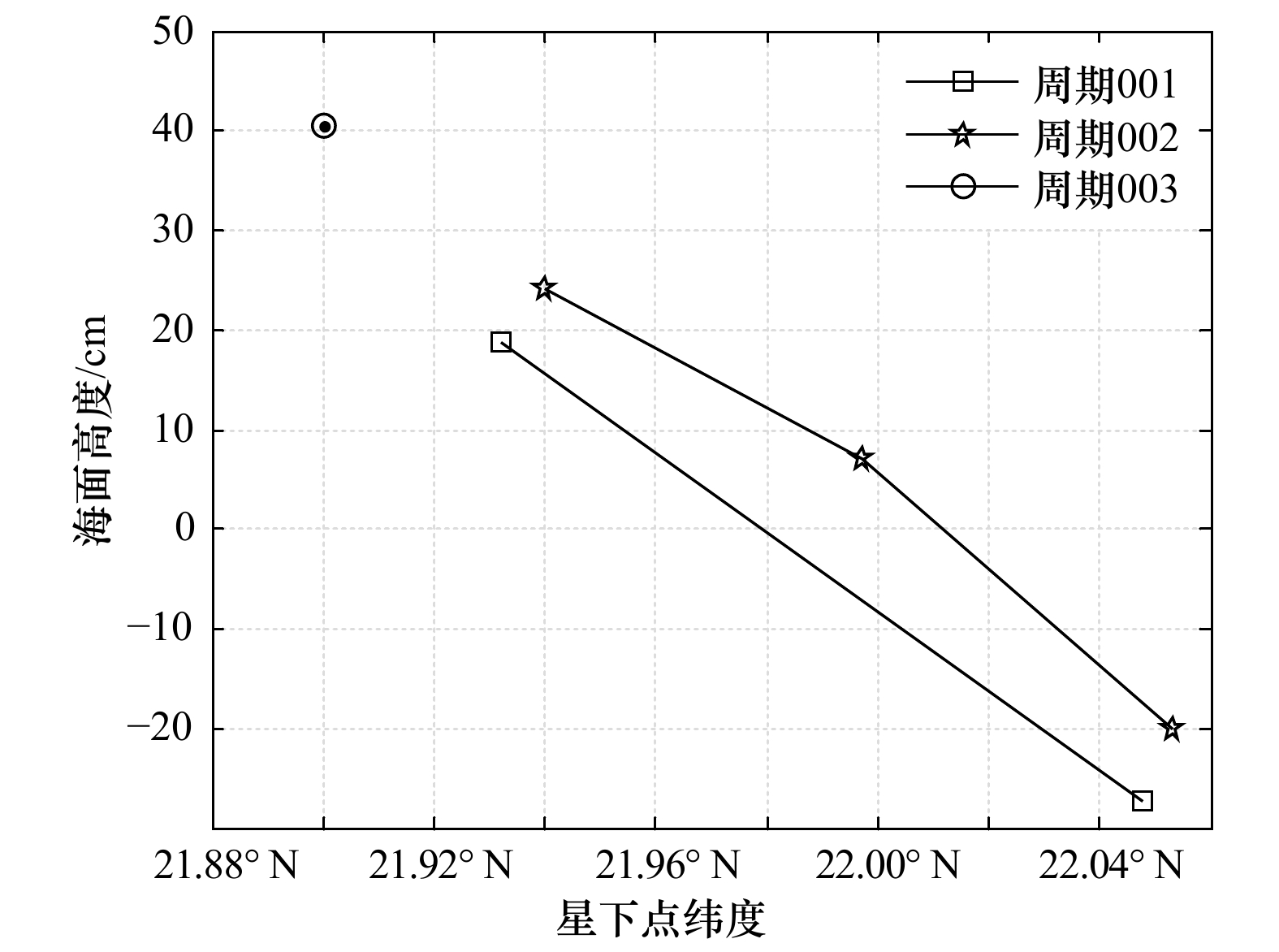
After the launch of China’s HY-2B altimeter in October 2018, NSOAS (National Satellite Ocean Application Service) conducted a HY-2B altimetry calibration experiment in Wanshan, Zhuhai. The experiment used the tide gauge along the coast to conduct the calibration experiment from November 3, 2018 to December 12, 2018, near the sub-satellite point of the HY-2B transit orbit 375 on Zhiwan Island. During the experiment period, HY-2B revisited the calibration point three times, and the results showed that the three-period HY-2B altimetry calibration bias were (3.06±3.48) cm, (2.85±1.03) cm, −7.41 cm; there was a certain drift in the calibration bias in the first three cycles, and subsequent calibration work was required to determine the cause of the drift.
After the launch of China’s HY-2B altimeter in October 2018, NSOAS (National Satellite Ocean Application Service) conducted a HY-2B altimetry calibration experiment in Wanshan, Zhuhai. The experiment used the tide gauge along the coast to conduct the calibration experiment from November 3, 2018 to December 12, 2018, near the sub-satellite point of the HY-2B transit orbit 375 on Zhiwan Island. During the experiment period, HY-2B revisited the calibration point three times, and the results showed that the three-period HY-2B altimetry calibration bias were (3.06±3.48) cm, (2.85±1.03) cm, −7.41 cm; there was a certain drift in the calibration bias in the first three cycles, and subsequent calibration work was required to determine the cause of the drift.
2021, 43(6): 145-156.
doi: 10.12284/hyxb2021086
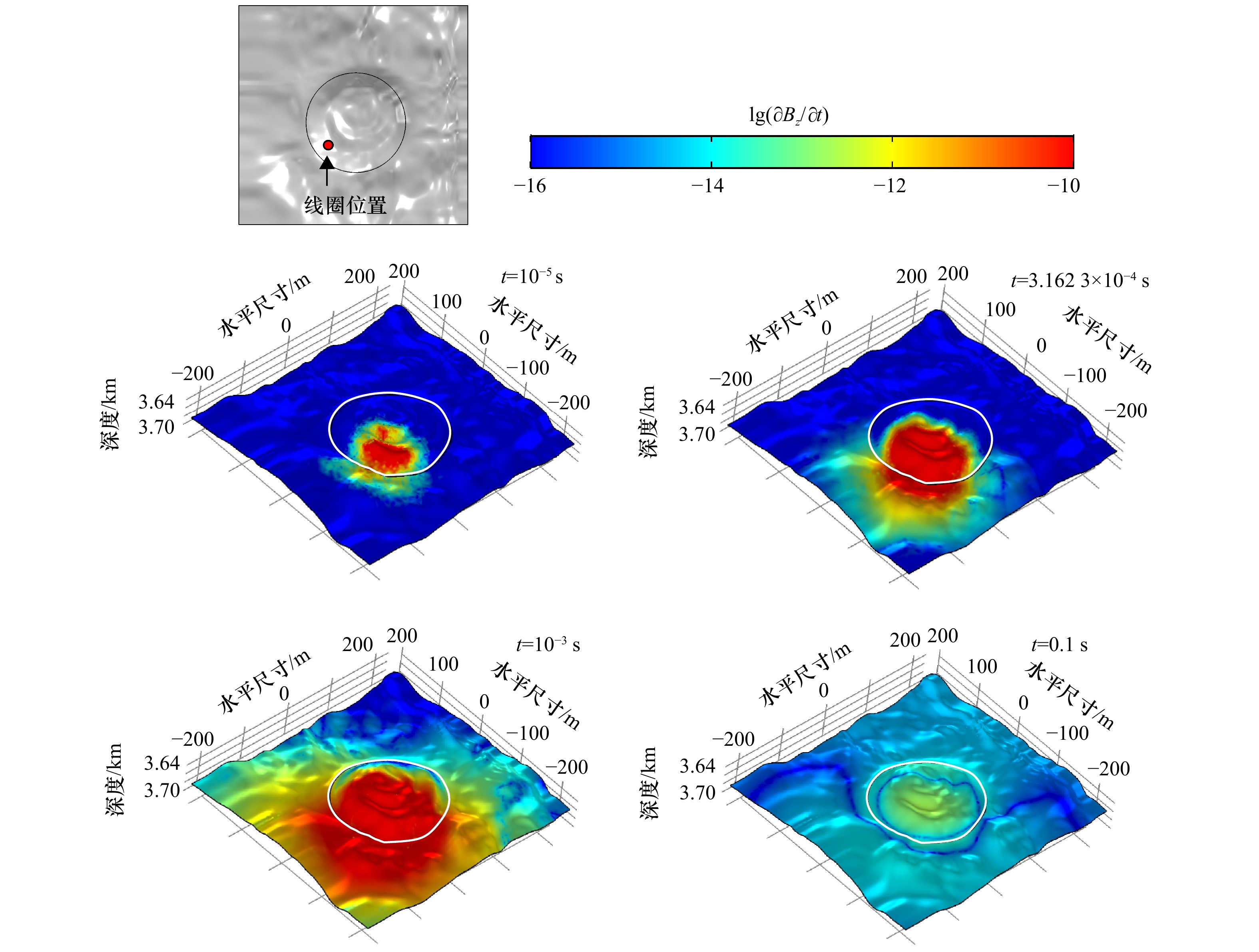
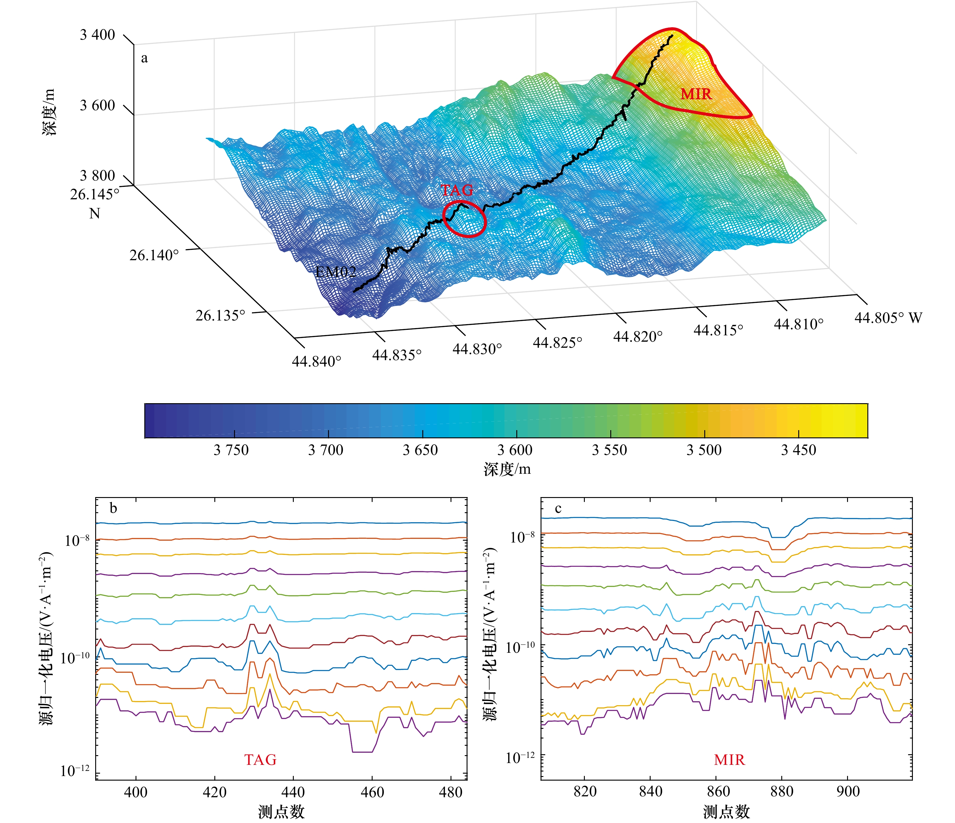
Abstract:
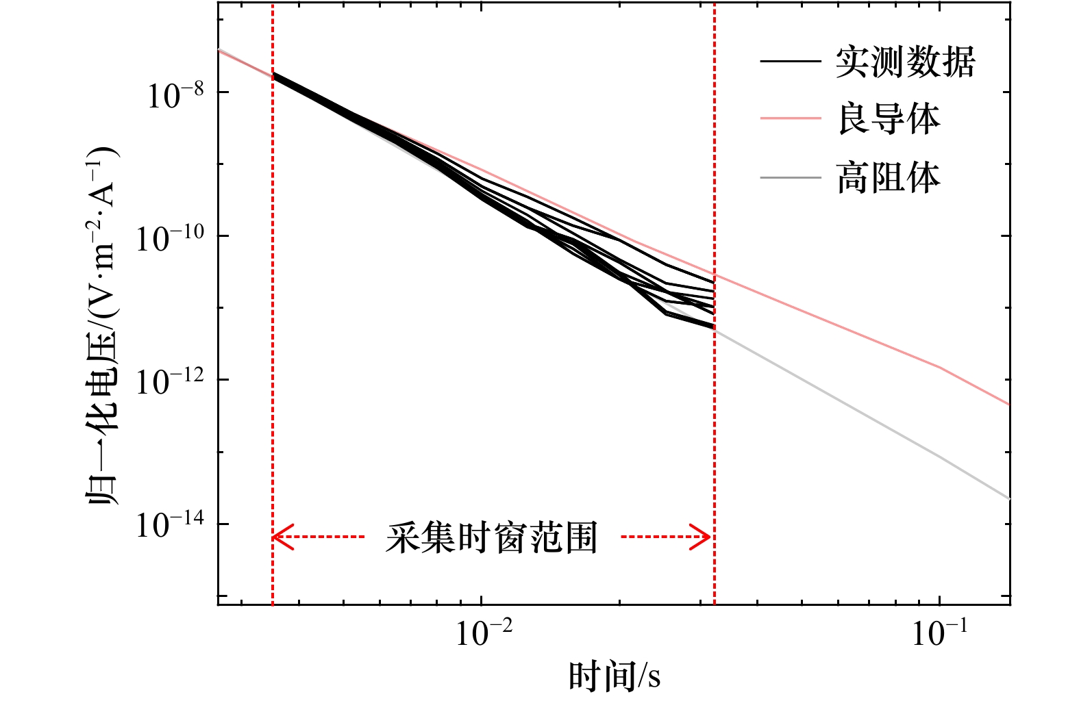
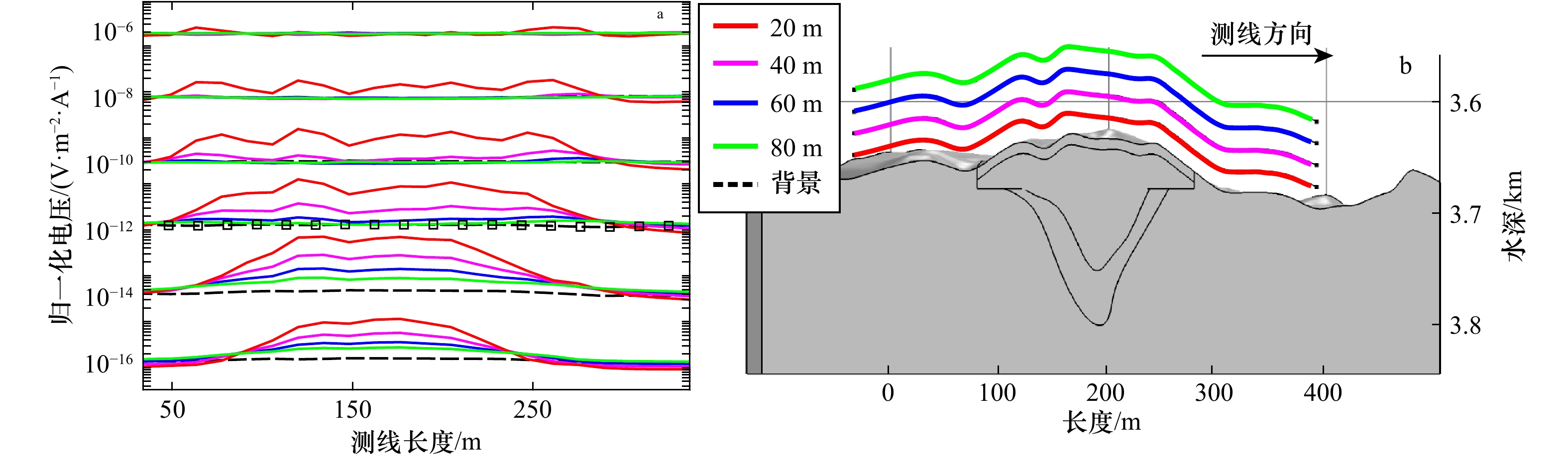
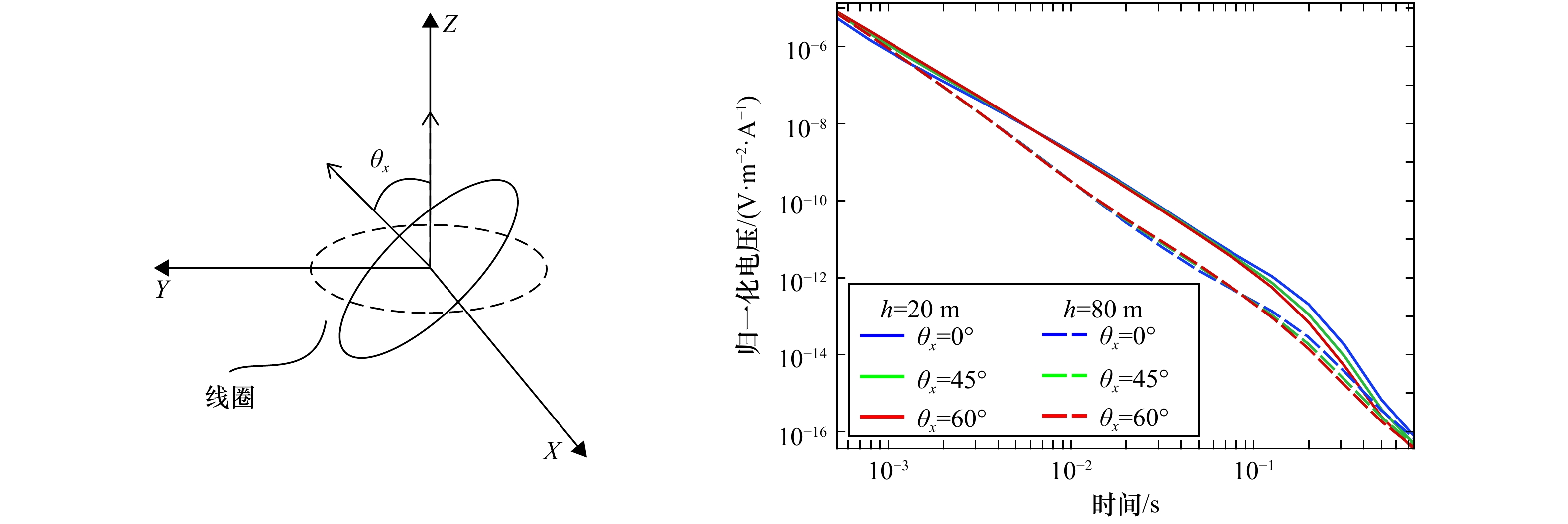
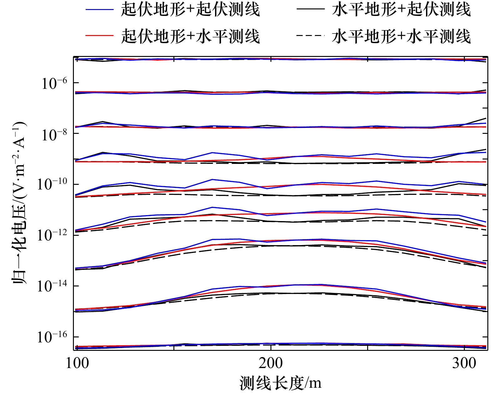
It is crucial to evaluate seafloor massive sulfides (SMS) in terms of their special distribution. Transient electromagnetic method (TEM) is ideal for land mineral deposits prospecting, but the complicated seafloor topography, inner structure of sulfide deposits and measuring conditions in the hydrothermal field pose a great challenge to its application in the ocean. In order to verify the application potential of TEM in deep-sea exploration, a 3D forward modeling scheme was developed with finite element method, combining with bathymetry data and drilling results. The method was then applied to the TAG hydrothermal field, Mid-Atlantic Ridge, and the result was well fitted with acquired TEM data. By comparing the forward simulation results under different instrument positions, attitudes and altitude, we found that the coincident loop system could effectively detect the active TAG mound ore body when the altitude was less than 60 meters. Complex seafloor topography and how the instrument was being towed could significantly disturb the early time response, while the instrument attitude also made an influence on the detected signal. Therefore, it was necessary to combine the bathymetry data, instrument positioning data and attitude data in the research area to better interpret the measured TEM responses.
It is crucial to evaluate seafloor massive sulfides (SMS) in terms of their special distribution. Transient electromagnetic method (TEM) is ideal for land mineral deposits prospecting, but the complicated seafloor topography, inner structure of sulfide deposits and measuring conditions in the hydrothermal field pose a great challenge to its application in the ocean. In order to verify the application potential of TEM in deep-sea exploration, a 3D forward modeling scheme was developed with finite element method, combining with bathymetry data and drilling results. The method was then applied to the TAG hydrothermal field, Mid-Atlantic Ridge, and the result was well fitted with acquired TEM data. By comparing the forward simulation results under different instrument positions, attitudes and altitude, we found that the coincident loop system could effectively detect the active TAG mound ore body when the altitude was less than 60 meters. Complex seafloor topography and how the instrument was being towed could significantly disturb the early time response, while the instrument attitude also made an influence on the detected signal. Therefore, it was necessary to combine the bathymetry data, instrument positioning data and attitude data in the research area to better interpret the measured TEM responses.


2021, 43(6): 157-170.
doi: 10.12284/hyxb2021084
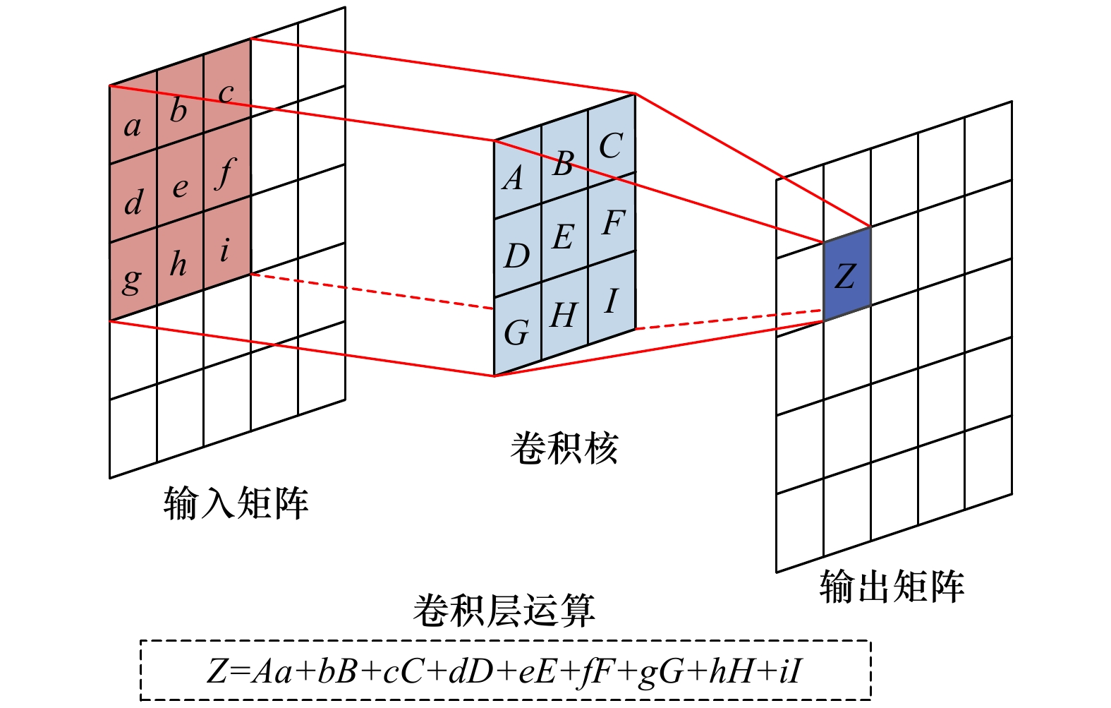
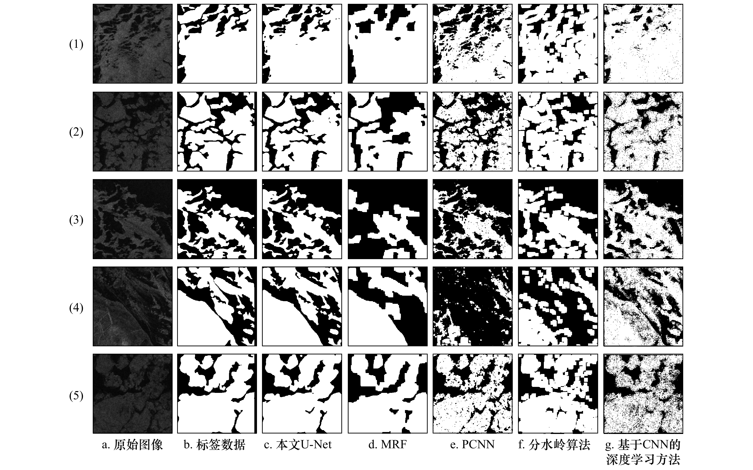
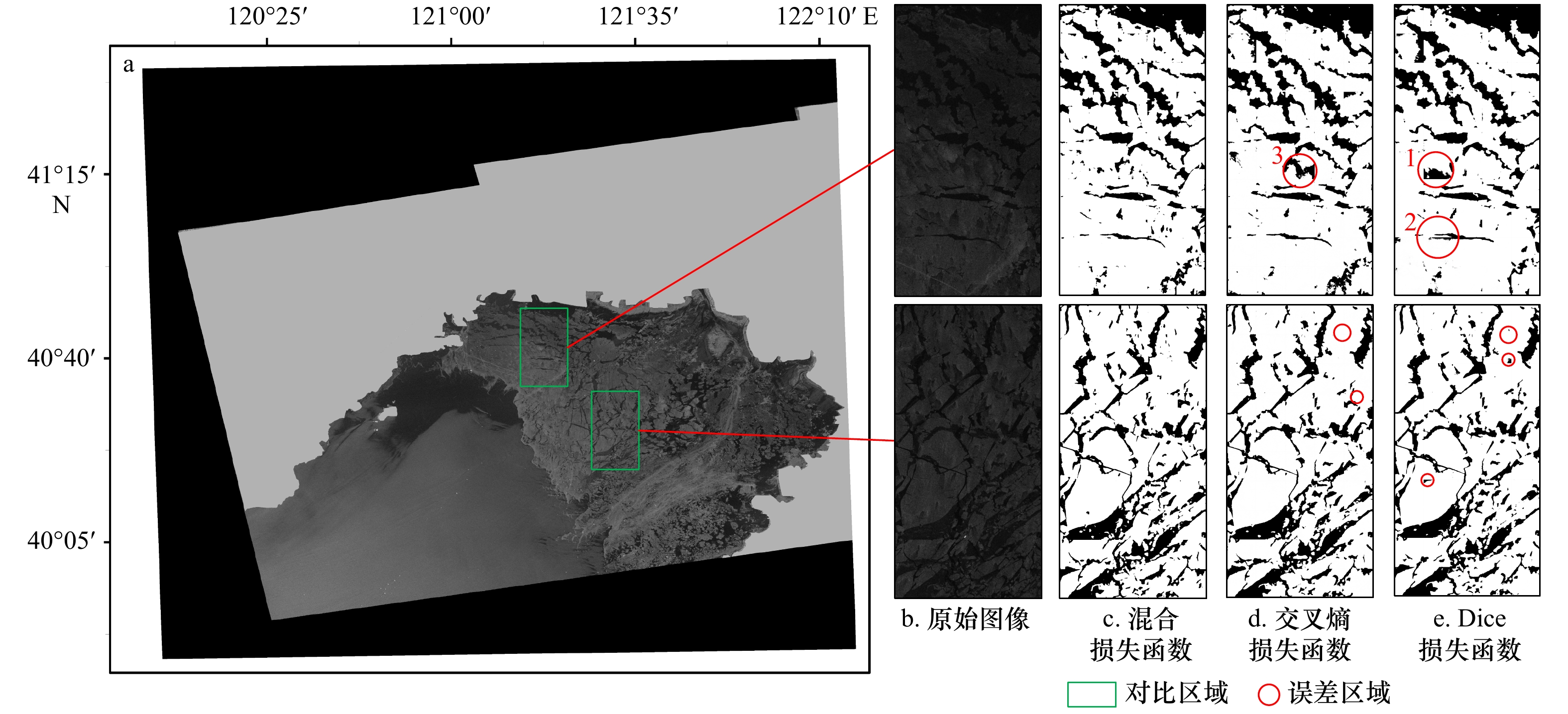
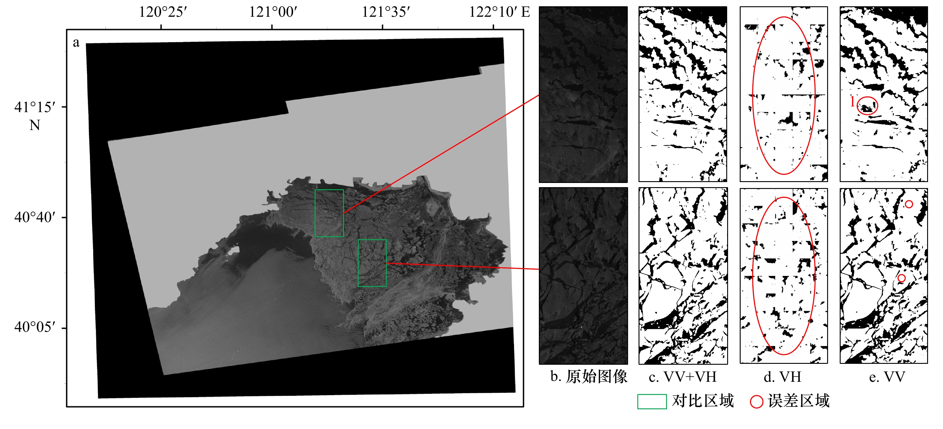
Abstract:
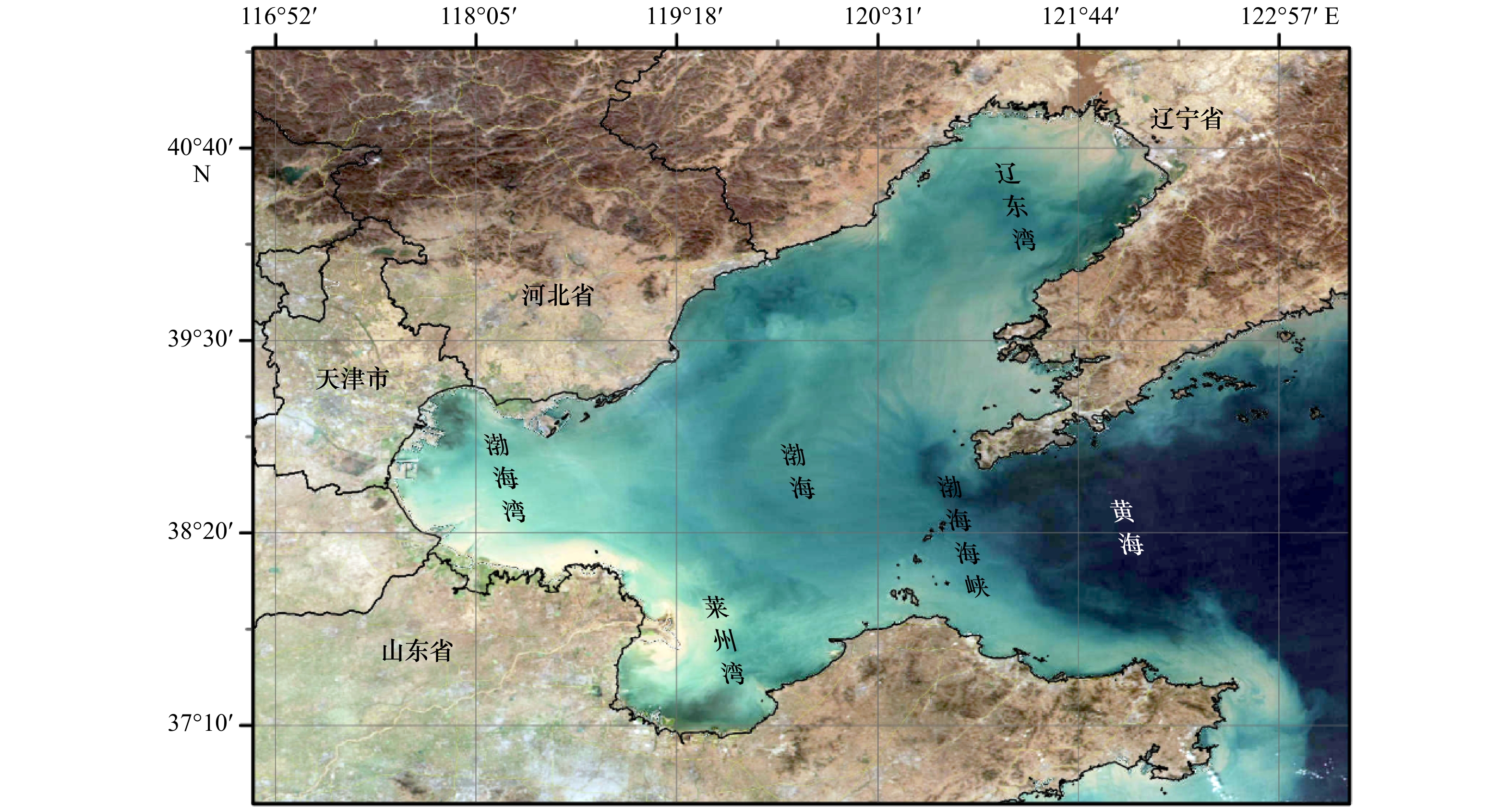
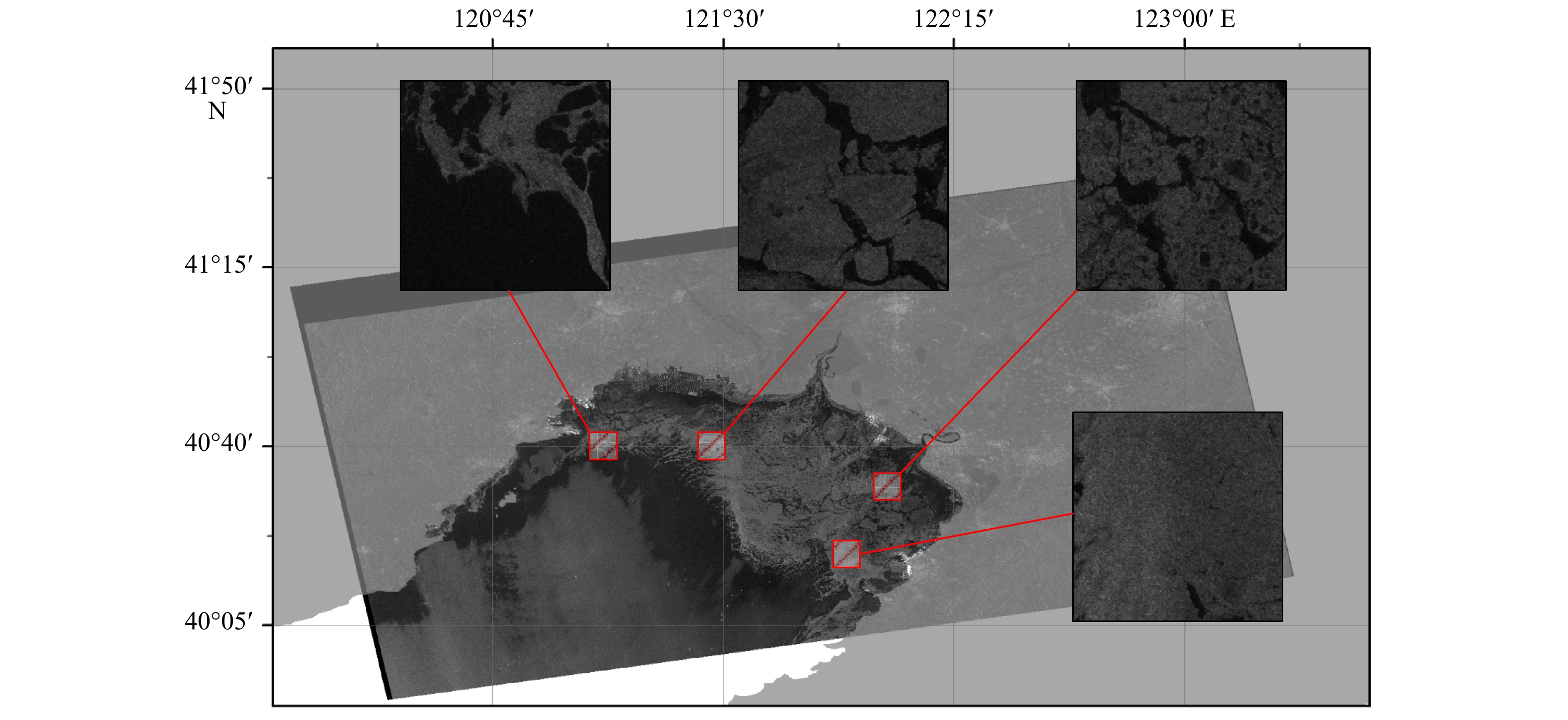
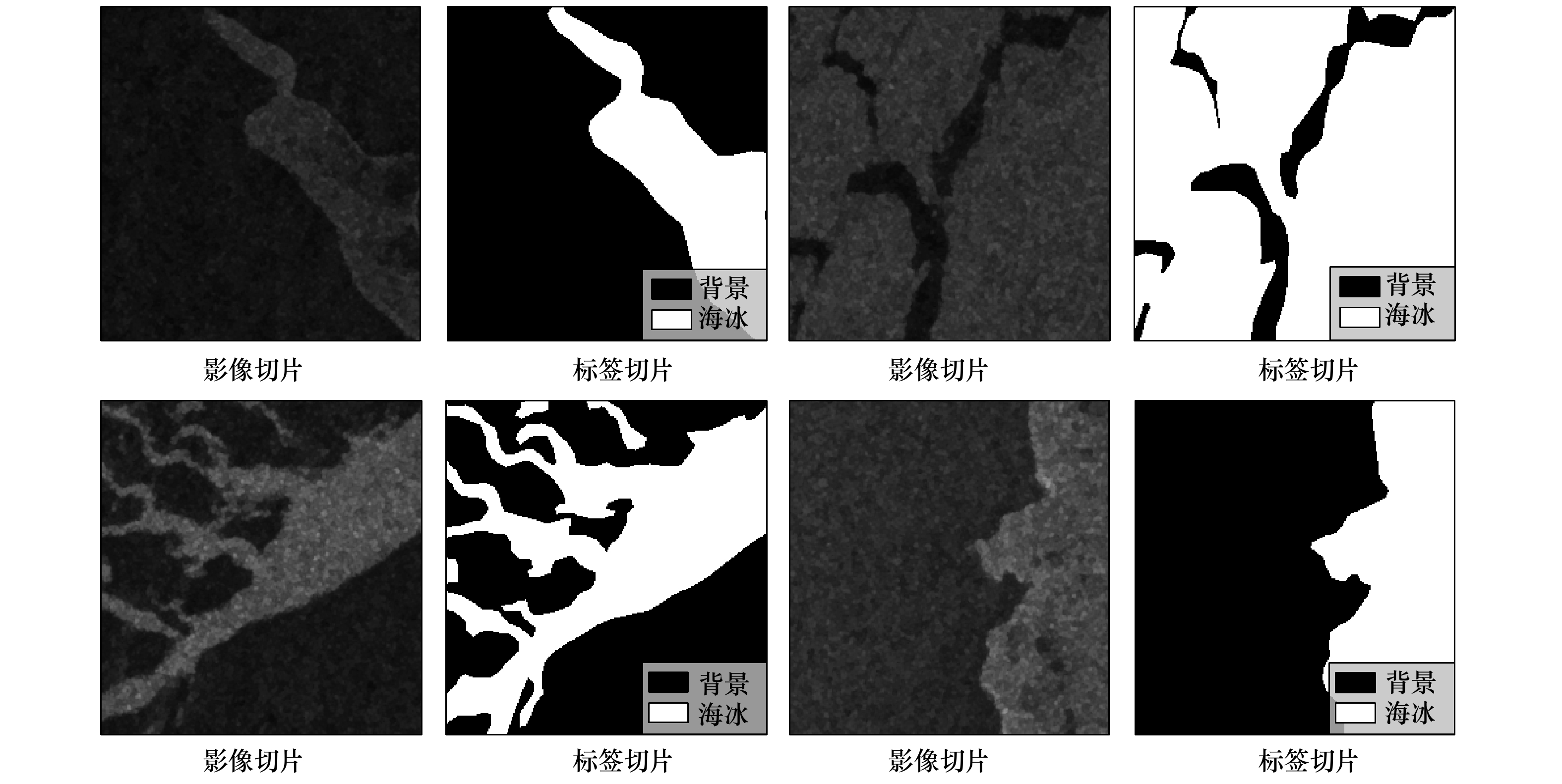
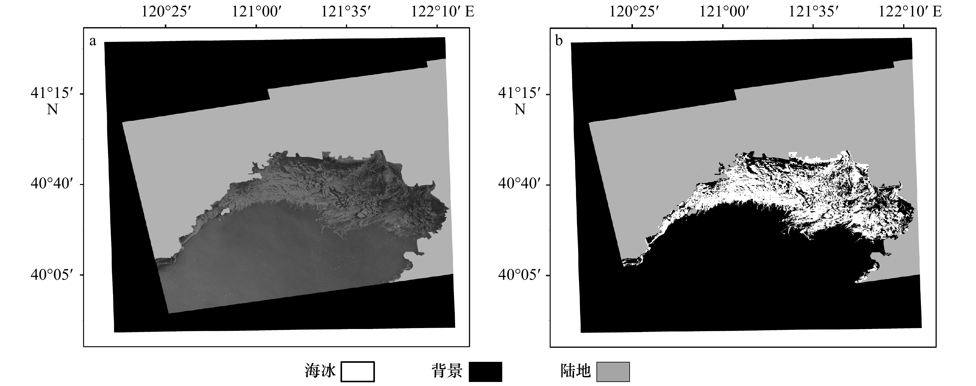
The Bohai Sea is an important economic zone of China. Sea ice has been a significant threat to the human activities around the Bohai Sea. As the imaging capability of synthetic aperture radar (SAR) is independent of sun illumination and cloud condition, it is of great significance to detect the sea ice of the Bohai Sea from SAR images. Due to the limitation of the feature extraction mechanism, the accuracies of traditional sea ice detection methods need to be improved. Deep learning has a strong self-learning ability and is suitable for image detection. Here, we employ the well-known deep learning framework, U-Net, as the basic structure, and design a hybrid loss function to optimize the U-Net model, forming a hybrid loss U-Net model for sea ice detection in the Bohai Sea. The Sentinel-1 dual-polarization (VV and VH) SAR images are the inputs of the model. We compare the hybrid loss U-Net model with several traditional methods (Pulse Coupled Neural Network, Markov Random Field and Watershed Algorithm) and deep learning method based on CNN. Experiments show that the hybrid loss U-Net-based model achieves 97.567%, 98.769%, 98.767% and 98.771% in IoU, F1_Score, Precision and Recall respectively, outperforming the other methods. Compared with VV single-polarized input, the detection results of dual-polarized information input are 0.375%, 0.111%, 0.639% and 0.740% higher in F1_Score, Precision, Recall and IoU respectively. The detection results of the hybrid loss model are 1.129%, 0.947%, 1.794% and 2.231% higher than those of the non-hybrid loss function in F1_Score, Precision, Recall and IoU respectively. The model could effectively detect details such as ice water line, inter-ice water and ice gap. Our model is applied to detect the sea ice of a whole SAR image in the Bohai Sea, which can provide technical supports for sea ice monitoring, sea ice change analysis and sea ice prediction.
The Bohai Sea is an important economic zone of China. Sea ice has been a significant threat to the human activities around the Bohai Sea. As the imaging capability of synthetic aperture radar (SAR) is independent of sun illumination and cloud condition, it is of great significance to detect the sea ice of the Bohai Sea from SAR images. Due to the limitation of the feature extraction mechanism, the accuracies of traditional sea ice detection methods need to be improved. Deep learning has a strong self-learning ability and is suitable for image detection. Here, we employ the well-known deep learning framework, U-Net, as the basic structure, and design a hybrid loss function to optimize the U-Net model, forming a hybrid loss U-Net model for sea ice detection in the Bohai Sea. The Sentinel-1 dual-polarization (VV and VH) SAR images are the inputs of the model. We compare the hybrid loss U-Net model with several traditional methods (Pulse Coupled Neural Network, Markov Random Field and Watershed Algorithm) and deep learning method based on CNN. Experiments show that the hybrid loss U-Net-based model achieves 97.567%, 98.769%, 98.767% and 98.771% in IoU, F1_Score, Precision and Recall respectively, outperforming the other methods. Compared with VV single-polarized input, the detection results of dual-polarized information input are 0.375%, 0.111%, 0.639% and 0.740% higher in F1_Score, Precision, Recall and IoU respectively. The detection results of the hybrid loss model are 1.129%, 0.947%, 1.794% and 2.231% higher than those of the non-hybrid loss function in F1_Score, Precision, Recall and IoU respectively. The model could effectively detect details such as ice water line, inter-ice water and ice gap. Our model is applied to detect the sea ice of a whole SAR image in the Bohai Sea, which can provide technical supports for sea ice monitoring, sea ice change analysis and sea ice prediction.


 Email alert
 RSS
RSS