

Response of the Qing’an Bay beach in Xuwen to Typhoon Bebinca based on high frequency observation data
-
摘要: 风暴是造成海滩剧烈变化的重要因子。由于观测环境的恶劣,目前极少有风暴过程中海滩响应的现场高频观测工作。本研究在2018年台风“贝碧嘉”期间对徐闻青安湾海滩开展了历时6天半的高频观测,获得了全时水动力要素和164组逐时海滩滩面高程变化数据。通过分析表明:(1)青安湾海域风暴增水及波浪受控于海南岛−雷州半岛特有的地形地貌和台风“贝碧嘉”的多变路径,增水稳定在0.38~0.5 m之间,而波高先由0.78 m衰减至0.43 m,再增加至0.56 m;(2)海滩剖面地形变化总体表现为滩肩侵蚀,形成水下沙坝,滩肩响应过程分为快速向下侵蚀、缓慢侵蚀至最大值、振荡回淤恢复3个阶段,台风期间滩肩振荡恢复幅度可达最大侵蚀深度的1/4;(3)海滩的风暴响应过程主要由4个模态耦合而成:第一模态体现大潮滩肩侵蚀生成水下沙坝过程;第二模态体现风暴滩肩侵蚀,补偿大潮滩肩侵蚀位置和进一步促进沙坝形成过程;第三模态揭示了波浪二次破碎位置的上冲流和离岸底流使泥沙发生双向输移过程;第四模态表明台风大浪使得碎波带内泥沙大量悬浮,在沿岸流和离岸流作用下部分悬沙进入深水区,可能造成海滩泥沙的永久亏损。Abstract: Tropical cyclone is one of the most active dynamic factors for beach evolution. However, there are few field observations of beach during storms due to terrible working conditions. In this paper, 6 and a half days of high-frequency observation during the Typhoon Bebinca was conducted at the Qing’an Bay beach. The observation data included full-time hydrodynamics and 164 groups hourly variation of beach surface elevation. Three main analysis results were identified: (1) Controlled by the spatial distribution of Hainan Island-Leizhou Peninsula and the changeable track of the Typhoon Bebinca, the storm surge was maintained between 0.38−0.5 m, the wave height first decreased from 0.78 m to 0.43 m and then increased to 0.56 m. (2) The beach berm was eroded and a sand bar was formed under the water. There were three response stages of the beach berm during the Typhoon Bebinca, eroded downward fast, eroded slowly to the maximum, and recovered by oscillating deposition. The recovery amplitude could reach one quarter of the maximum erosion depth during the Typhoon Bebinca. (3) The response process of the Qing'an Bay beach to Typhoon Bebinca was mainly composed of four modes. The first mode reflected the erosion process of the spring tidal beach berm and the formation of the sand bar. The second mode indicated the erosion of the storm beach berm, the compensatory recovery of the spring tidal beach berm and the growth of the sand bar. The third mode revealed the bilateral transport process of sediment caused by the uprush and undertow at the secondary breaking position of waves. The fourth mode showed that the strong waves suspended the sediment in the surf zone, and some of the suspended sediment which was transported to the deep-water area by littoral current and offshore current may lost permanently.
-
Key words:
- high frequency observation /
- Qing’an Bay /
- Typhoon Bebinca /
- beach response /
- mode
-

图 3 台风水动力过程线(剔除记波仪水深不足时的波浪异常数据)
Fig. 3 Hydrodynamic processes during the typhoon (eliminated invalid data of wave recorder when water depth was insufficient)
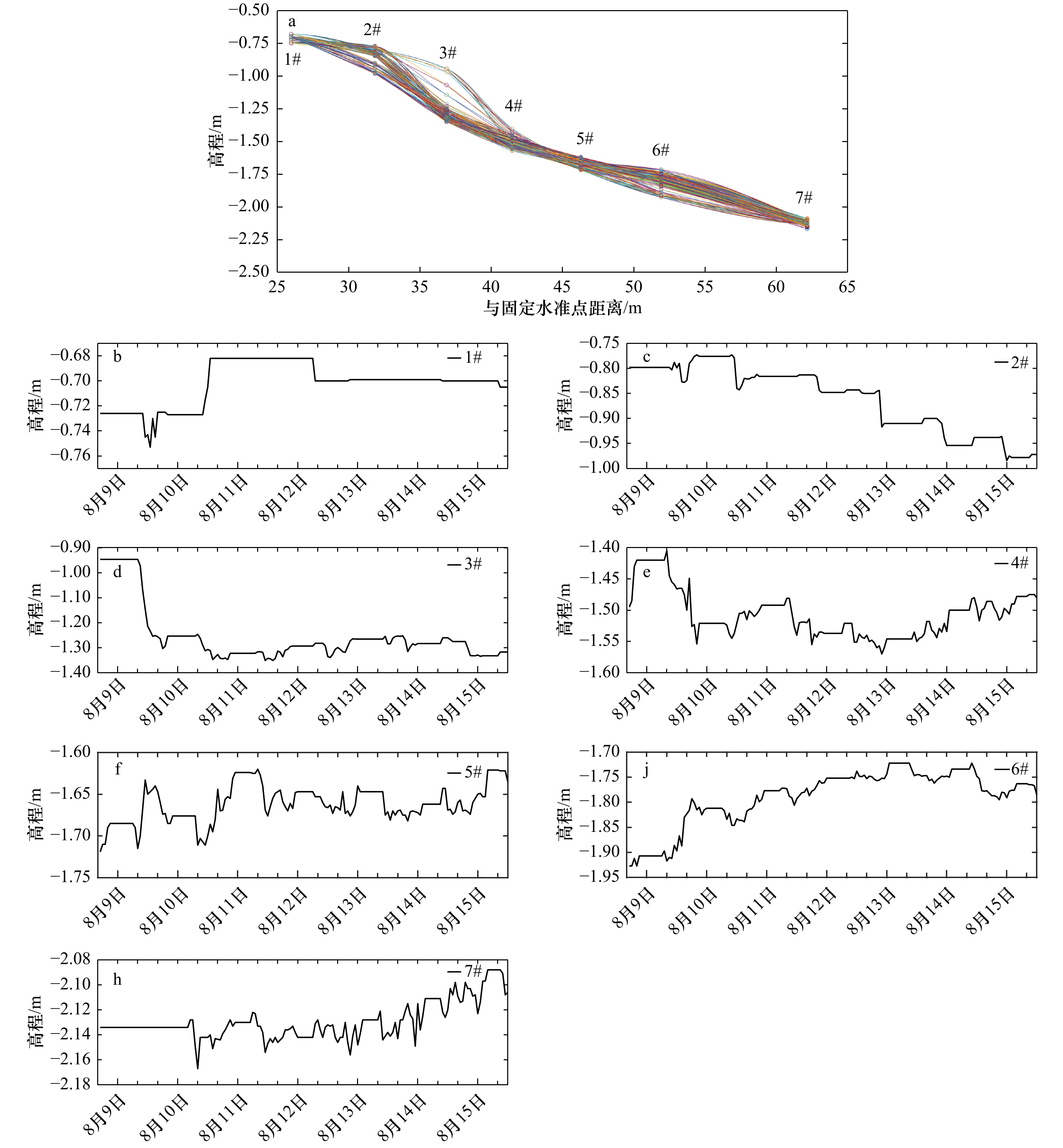
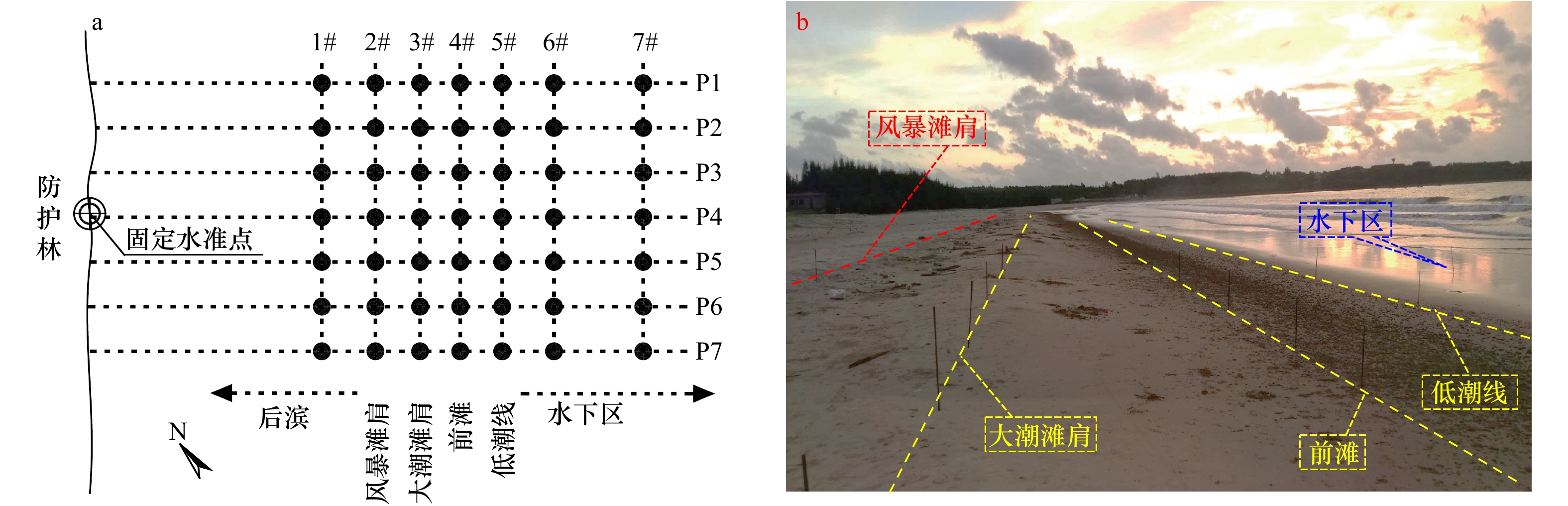
图 4 实测剖面变化形态与各观测桩高程变化过程
Fig. 4 Shape of the observed profile and elevation processes of stake

图 6 青安湾风暴增水水源区面积变化
R1、R2和R3分别是台风生成时、第一次登陆时和离青安湾最近时风暴增水的水源区半径
Fig. 6 Water source area of storm surge in the Qing’an Bay
R1 is the radius of water source circle at 8:00 on 9th August, 2018. R2 is the radius of water source circle at the landing moment 9:00 on 10th August, 2018. R3 is the radius of the water source when Typhoon Bebinca is closest to the Qing’an Bay at 11:00 on 10th August, 2018
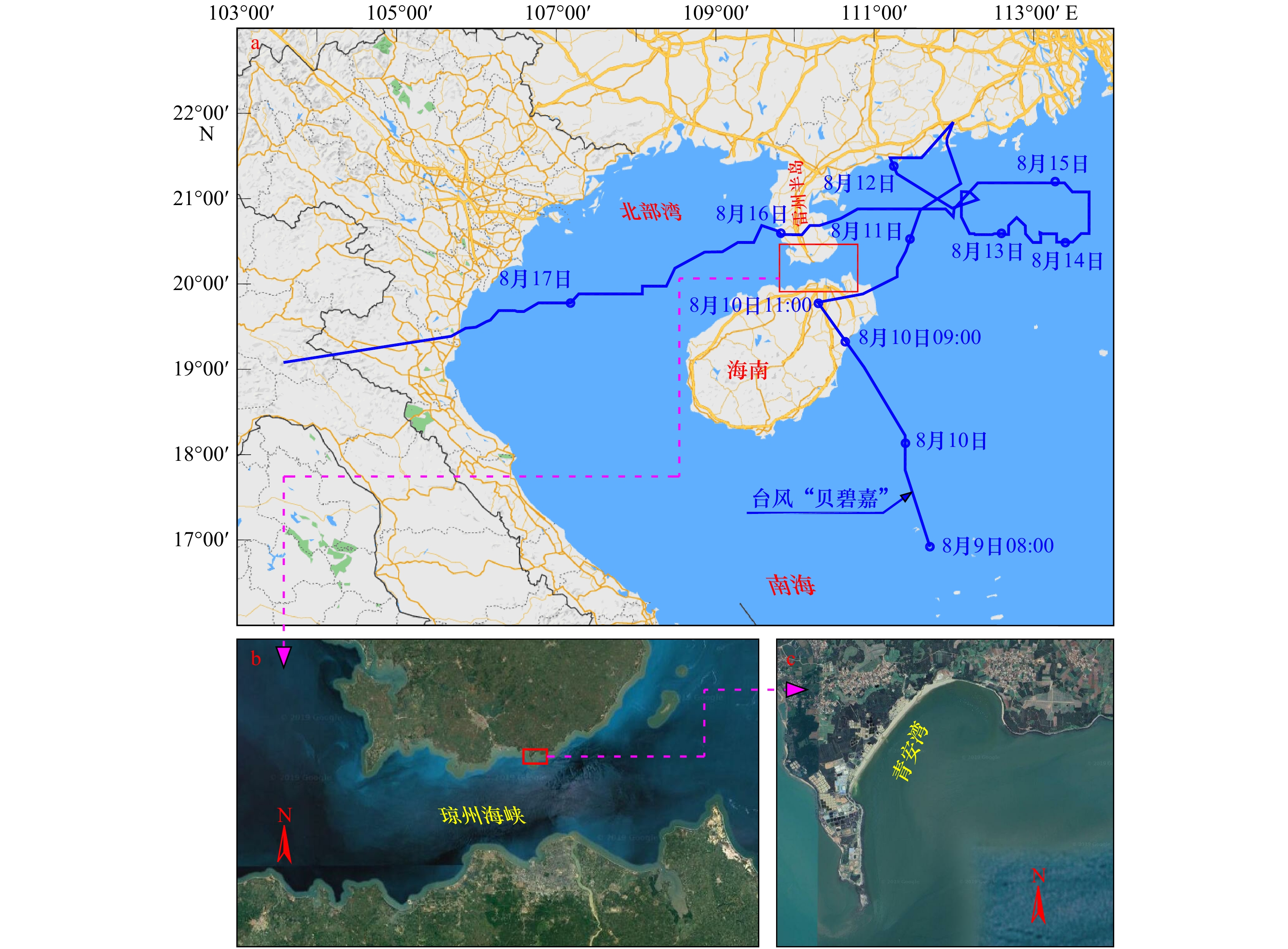
表 1 台风“贝碧嘉”路径信息表
Tab. 1 The track information of Typhoon Bebinca
时间 位置 台风强度 7级风圈半径 台风中心与青安湾距离 2018年8月9日08时 南海西北部海面 7级,15 m/s 400 km 2018年8月10日09时 海南省琼海市沿海登陆 7级,15 m/s 112 km 2018年8月10日11时 海南省海口市遵谭镇 7级,15 m/s 47 km(最近点) 2018年8月10日14时 海南省文昌市翁田镇 7级,15 m/s 75 km 2018年8月10日15时至11日10时 再次进入南海向东北移动 7级,15 m/s 80~226 km 2018年8月11日10时35分 阳江海陵岛再次登陆 7级,15 m/s 226 km 2018年8月12日14时 茂名电白附近海域 8级,18 m/s 100~150 km 210 km 2018年8月13日08时 阳江南面海域,命名“贝碧嘉” 8级,18 m/s 100~150 km 276 km 2018年8月13日20时 阳江南面海域 9级,23 m/s 100~180 km 315 km 2018年8月14日17时 阳江南面海域 10级,25 m/s 100~190 km 355 km 2018年8月15日21时 阳江南面海域,向西移 10级,25 m/s 100~150 km 68~355 km 2018年8月15日21时40分 湛江雷州东里镇沿海登陆 9级,23 m/s 100~150 km 54 km 2018年8月16日02时 移入北部湾 8级,20 m/s 50~110 km 72 km 2018年8月16日5时至17日05时 北部湾,一直向西 10级,25 m/s 60~160 km 108~456 km 2018年8月17日07时 越南北部登陆  下载: 导出CSV
表 2 台风“贝碧嘉”过境期间研究区域附近海域波高情况
Tab. 2 Wave heights in the vicinity sea during the Typhoon Bebinca
时间 北部湾波高/m 琼州海峡波高/m 雷州半岛以东波高/m 2018年8月9日 1.3~1.8 1.3~1.8 1.8~2.3 2018年8月10日 1.8~2.3 1.8~2.3 3.0~4.0 2018年8月11日 1.8~2.3 1.8~2.3 2.5~3.5 2018年8月12日 1.8~2.3 1.8~2.3 2.5~3.2 2018年8月13日 2.0~2.5 2.0~2.5 3.0~3.8 2018年8月14日 1.8~2.3 1.8~2.3 4.0~4.8 2018年8月15日 1.8~2.3 1.8~2.3 3.0~3.5 注:数据来源于海南省海洋与渔业厅。
下载: 导出CSV
表 3 台风水动力统计
Tab. 3 Typhoon hydrodynamic statistics
日期 最大增水/
m破碎波高/
m有效波高/
m波周期
/s天文潮 2018年8月9日 0.38 0.78 0.55 7.00 中潮 2018年8月10日 0.42 0.67 0.43 6.39 中潮 2018年8月11日 0.40 0.56 0.38 5.55 大潮 2018年8月12日 0.50 0.43 0.27 5.29 大潮 2018年8月13日 0.50 0.51 0.34 7.00 大潮 2018年8月14日 0.40 0.49 0.29 6.25 中潮 2018年8月15日 − 0.56 0.38 6.25 中潮 注:−表示缺失。由于实测截止时间为8月15日12时,故无法确定15日全天的最大实测增水值。
下载: 导出CSV
表 4 特征值排序
Tab. 4 Sorting table of eigenvalues
特征值 λ1 λ2 λ3 λ4 λ5 λ6 λ7 数值 0.016 0 0.003 9 0.001 1 0.000 5 0.000 2 0.000 1 0.000 1 贡献量 73.18% 17.95% 5.12% 2.22% 0.75% 0.50% 0.28%
下载: 导出CSV
表 5 特征值取样误差分析
Tab. 5 Sampling error analysis
特征值 λ2 λ3 λ4 λ5 $ {\lambda }_{k} $ 0.003 9 0.001 1 0.000 5 0.000 2 $ {\Delta \lambda }_{k} $ 0.002 085 0.000 588 0.000 267 0.000 107 $ {\lambda }_{k}-{\lambda }_{k+1} $ 0.002 8 0.000 6 0.000 3 0.000 1 $ \dfrac{{\Delta \lambda}_{k}}{\left|{\lambda }_{{k}'}-{\lambda }_{k}\right|} $ 0.745 0.980 0.891 1.069
下载: 导出CSV
-
[1] The Nearshore Processes Community. The future of nearshore processes research[J]. Shore & Beach, 2015, 83(1): 13−38. [2] Holman R A, Haller M C, Lippmann T C, et al. Advances in nearshore processes research: four decades of process[J]. Shore & Beach, 2015, 83(1): 39−52. [3] Basco D. Erosion of beaches on St. Martin Island during hurricanes Luis and Marilyn[J]. Shore and Beach, 1996, 64(4): 15−20. [4] Stockdon H F, Sallenger A H, Holman R A, et al. A simple model for the spatially-variable coastal response to hurricanes[J]. Marine Geology, 2007, 238: 1−20. doi: 10.1016/j.margeo.2006.11.004 [5] Anthony E J. Storms, shoreface morphodynamics, sand supply, and the accretion and erosion of coastal dune barriers in the southern North Sea[J]. Geomorphology, 2013, 199(5): 8−21. [6] Costas S, Alejo I, Vila-Concejo A, et al. Persistence of storm-induced morphology on a modal low-energy beach: A case study from NW-Iberian Peninsula[J]. Marine Geology, 2005, 224(1/4): 43−56. [7] Otvos E G. Beach aggradation following hurricane landfall: impact comparisons from two contrasting hurricanes, northern Gulf of Mexico[J]. Journal of Coastal Research, 2004, 20: 326−339. [8] Sedrati M, Anthony E J. Storm-generated morphological change and longshore sand transport in the intertidal zone of a multi-barred macrotidal beach[J]. Marine Geology, 2007, 244(1/4): 209−229. [9] 童宵岭, 时连强, 夏小明, 等. 1211号台风对浙江象山皇城海滩剖面的影响分析[J]. 海洋工程, 2014, 32(1): 84−90. doi: 10.3969/j.issn.1005-9865.2014.01.011Tong Xiaoling, Shi Lianqiang, Xia Xiaoming, et al. Response of sedimentary and geomorphic characteristics to 1211 typhoon on Zhejiang Huangcheng beach[J]. The Ocean Engineering, 2014, 32(1): 84−90. doi: 10.3969/j.issn.1005-9865.2014.01.011 [10] Morton R A, Gibeaut J C, Paine J G. Meso-scale transfer of sand during and after storms: implications for prediction of shoreline movement[J]. Marine Geology, 1995, 126(1/4): 161−179. [11] Houser C, Hamilton S. Sensitivity of post-hurricane beach and dune recovery to event frequency[J]. Earth Surface Processes and Landforms, 2009, 34(5): 613−628. doi: 10.1002/esp.1730 [12] Dissanayake P, Brown J, Karunarathna H. Impacts of storm chronology on the morphological changes of the Formby beach and dune system, UK[J]. Natural Hazards and Earth System Sciences, 2015, 15(7): 1533−1543. doi: 10.5194/nhess-15-1533-2015 [13] Thuan D H, Binh L T, Viet N T, et al. Typhoon impact and recovery from continuous video monitoring: a case study from Nha Trang Beach, Vietnam[J]. Journal of Coastal Research, 2016, 75: 263−267. doi: 10.2112/SI75-053.1 [14] Ding D, Yang J C, Li G X, et al. A geomorphological response of beaches to Typhoon Meari in the eastern Shandong Peninsula in China[J]. Acta Oceanologica Sinica, 2015, 34(9): 126−135. doi: 10.1007/s13131-015-0644-5 [15] Sallebger Jr A H, Stockdon H F, Fauver L, et al. Hurricanes 2004: an overview of their characteristics and coastal change[J]. Estuaries and Coasts, 2006, 29(6A): 880−888. [16] 李谷祺, 彭俊, 蔡锋, 等. 沙坝−泻湖岸型砂质海滩地貌对台风的响应特征[J]. 海洋地质动态, 2007, 23(8): 14−18. doi: 10.3969/j.issn.1009-2722.2007.08.004Li Guqi, Peng Jun, Cai Feng, et al. Response characteristics of sand Bar-Lagoon Beach Landform to typhoon[J]. Marine Geology Letters, 2007, 23(8): 14−18. doi: 10.3969/j.issn.1009-2722.2007.08.004 [17] 邵超, 戚洪帅, 蔡锋, 等. 海滩−珊瑚礁系统风暴响应特征研究——以1409号台风“威马逊”对清澜港海岸影响为例[J]. 海洋学报, 2016, 38(2): 121−130.Shao Chao, Qi Hongshuai, Cai Feng, et al. Study on storm-effects on beach-coral reef system—Taking the response of Qinglangang Coast on No. 1409 Typhoon Rammasun as an example[J]. Haiyang Xuebao, 2016, 38(2): 121−130. [18] 龚昊, 陈沈良, 钟小菁, 等. 海南岛东北部海滩侵蚀与恢复对连续台风的复杂响应[J]. 海洋学报, 2017, 39(5): 68−77.Gong Hao, Chen Shenliang, Zhong Xiaojing, et al. Complicated responses of beach erosion and restoration to consecutive typhoons along northeastern Hainan Island, China[J]. Haiyang Xuebao, 2017, 39(5): 68−77. [19] 朱士兵, 李志强. 雷州半岛南部海滩对1720号台风(卡努)的响应研究[J]. 热带海洋学报, 2019, 38(1): 96−103.Zhu Shibing, Li Zhiqiang. Study on beach response to Typhoon Khanun (No. 1720) along southern Leizhou Peninsula[J]. Journal of Tropical Oceanography, 2019, 38(1): 96−103. [20] Morton R A, Sallenger Jr A H. Morphological impacts of extreme storms on sandy beaches and barriers[J]. Journal of Coastal Research, 2003, 19(3): 560−573. [21] Sallenger Jr A H. Storm impact scale for barrier island[J]. Journal of Coastal Research, 2000, 16(3): 890−895. [22] 黎树式, 戴志军, 葛振鹏, 等. 强潮海滩响应威马逊台风作用动力沉积过程研究——以北海银滩为例[J]. 海洋工程, 2017, 35(3): 89−98.Li Shushi, Dai Zhijun, Ge Zhenpeng, et al. Sediment dynamic processes of macro-tidal beach in response to Typhoon Rammasun action—A case study of Yintan, Beihai[J]. The Ocean Engineering, 2017, 35(3): 89−98. [23] Ge Z, Dai Z, Pang W, et al. LIDAR-based detection of the post-typhoon recovery of a meso-macro-tidal beach in the Beibu Gulf, China[J]. Marine Geology, 2017, 391: 127−143. doi: 10.1016/j.margeo.2017.08.008 [24] 陈子燊, 王扬圣, 黄德全, 等. 台风影响下海滩前滨剖面时间变化差异性分析[J]. 热带海洋学报, 2009, 28(6): 1−6. doi: 10.3969/j.issn.1009-5470.2009.06.001Chen Zishen, Wang Yangsheng, Huang Dequan, et al. Analysis on temporal change of foreshore profile under tropical storms[J]. Journal of Tropical Oceanography, 2009, 28(6): 1−6. doi: 10.3969/j.issn.1009-5470.2009.06.001 [25] 于吉涛, 丁圆婷, 程璜鑫, 等. 0709号台风影响下粤东后江湾海滩地形动力过程研究[J]. 海洋学报, 2015, 37(5): 76−86.Yu Jitao, Ding Yuanting, Cheng Huangxin, et al. Study on beach morphodynamic processes of Houjiang Wan in east Guangdong under the influence of the typhoon (No. 0709)[J]. Haiyang Xuebao, 2015, 37(5): 76−86. [26] 包砺彦. 雷州半岛南部青安湾海滩的沉积特征和地形发育[J]. 热带海洋, 1989, 8(2): 75−83.Bao Liyan. Sedimentary characteristics and landform developments of Qingan Bay beach in southern Leizhou Peninsula[J]. Journal of Tropical Oceanography, 1989, 8(2): 75−83. [27] Masselink G, Hegge B J, Pattiarachi C B. Beach cusp morphodynamics[J]. Earth Surface Processes and Landforms, 1997, 22(12): 1139−1155. doi: 10.1002/(SICI)1096-9837(199712)22:12<1139::AID-ESP766>3.0.CO;2-1 [28] Sallenger Jr A H, Richmond B M. High-frequency sediment-level oscillation in the swash zone[J]. Marine Geology, 1984, 60: 155−164. doi: 10.1016/0025-3227(84)90148-8 [29] Li Z Q. Relationship between high-frequency sediment-level oscillations in the swash zone and inner surf zone wave characteristics under calm wave conditions[J]. Open Geosciences, 2016, 8: 787−798. [30] 戚洪帅, 蔡锋, 雷刚, 等. 华南海滩风暴响应特征研究[J]. 自然科学进展, 2009, 19(9): 975−985. doi: 10.3321/j.issn:1002-008X.2009.09.011Qi Hongshuai, Cai Feng, Lei Gang, et al. Study on storm response characteristics of South China Beach[J]. Progress in Natural Science, 2009, 19(9): 975−985. doi: 10.3321/j.issn:1002-008X.2009.09.011 [31] 蔡锋, 苏贤泽, 夏东兴, 等. 热带气旋前进方向两侧海滩风暴效应差异研究: 以海滩对0307号台风“伊布都”的响应为例[J]. 海洋科学进展, 2004, 22(4): 436−445. doi: 10.3969/j.issn.1671-6647.2004.04.005Cai Feng, Su Xianze, Xia Dongxing, et al. Study on the difference between storm effects of beaches on two sides of the tropical cyclone track—taking the responses of beaches to NO. 0307 Typhoon Imbudo as an example[J]. Advances in Marine Science, 2004, 22(4): 436−445. doi: 10.3969/j.issn.1671-6647.2004.04.005 [32] 万弘超, 李训强, 窦红刚. 海口港风暴潮特征分析[J]. 海洋预报, 2009, 26(2): 69−77. doi: 10.3969/j.issn.1003-0239.2009.02.009Wan Hongchao, Li Xunqiang, Dou Honggang. Analysis of storm surge characteristics in Haikou Port[J]. Marine Forecasts, 2009, 26(2): 69−77. doi: 10.3969/j.issn.1003-0239.2009.02.009 [33] 马经广, 杨武志. 台风“海鸥”与“威马逊”风暴增水的差异分析[J]. 广东水利水电, 2015(3): 20−24.Ma Jingguang, Yang Wuzhi. Analysis on the difference of storm surge between Typhoon Kalmaegi and Rammasun[J]. Guangdong Water Resources and Hydropower, 2015(3): 20−24. [34] 杨玄阁. 琼州海峡台风风暴潮诊断分析[D]. 广州: 华南理工大学, 2017.Yang Xuange. Diagnostic analysis of strom surges in the Qiongzhou Strait[D]. Guangzhou: South China University of Technology, 2017. [35] 黄山. 琼州海峡风暴潮数值模拟与不同台风路径对增水的影响研究[D]. 广州: 华南理工大学, 2016.Huang Shan. Numerical simulation of strom surges in the Qiongzhou Strait and study on the influence of different typhoon tracks on surges[D]. Guangzhou: South China University of Technology, 2016. [36] 吴洪宝, 吴蕾. 气候变率诊断和预测方法[M]. 北京: 气象出版社, 2010.Wu Hongbao, Wu Lei. Methods for Diagnosing and Forecasting Climate Variability[M]. Beijing: China Meteorological Press, 2010. [37] North G R, Bell T L, Cahalan R F, et al. Sampling errors in the estimation of empirical orthogonal function[J]. Monthly Weather Review, 1982, 110(7): 699−706. doi: 10.1175/1520-0493(1982)110<0699:SEITEO>2.0.CO;2 -


计量
- 文章访问数: 215
- HTML全文浏览量: 113
- PDF下载量: 5
- 被引次数: 0
