

Research on parameterized analysis method of 3D temperature field based on remote sensing data
-
摘要: 为了满足海洋研究以及海洋调查的需求,本文基于Argo剖面和海表面温度数据开发了一个新的拟合三维温度场的算法。选取西北太平洋区域作为验证算法有效的实验海区。该水域的经纬度范围设定为:30°~40°N, 140°~155°E, 水平分辨率为0.25°。深度方向为从海表到2 000 m水深,水域划分为29层。拟合算法首先将Argo温度剖面以5个深度划分为6层,分别为混合层、夹层、温跃层、过渡层、第一深层、第二深层,然后以第一猜想值和线性回归得到的海表面温度作为初始条件重构三维温度场。重构的三维温度场的剖面与原观测剖面的均方根误差较小,相关性较好,表明该算法是合理有效的。Abstract: To meet the needs of marine research and marine surveys, a new algorithm for fitting three-dimensional temperature fields was developed based on the Argo profile and sea surface temperature data. The Northwest Pacific region was selected as the experimental sea area to validate the algorithm. The latitude and longitude range of the water area was set as: 30°–40°N, 140°–155°E, and the horizontal resolution was 0.25°. The depth direction was from the sea surface to 2 000 m underwater, and the water area was divided into 29 layers. First the fitting algorithm divided the Argo temperature profile into six layers with five depths. The layers were mixed layer, inter layer, thermocline, transition layer, the first deep layer, and the second deep layer. The first guess and the sea surface temperature obtained by linear regression were used as the initial conditions to reconstruct the three-dimensional temperature field. The RMSE of the reconstructed three-dimensional temperature field was small and well correlated with the original observation profile, indicating that the algorithm is reasonable and effective.
-

图 1 西北太平洋海域及研究区域地形分布
黑色虚线框表示实验海区
Fig. 1 Topography of the northwest Pacific Ocean and the study area
The black dotted box indicates the experimental sea area
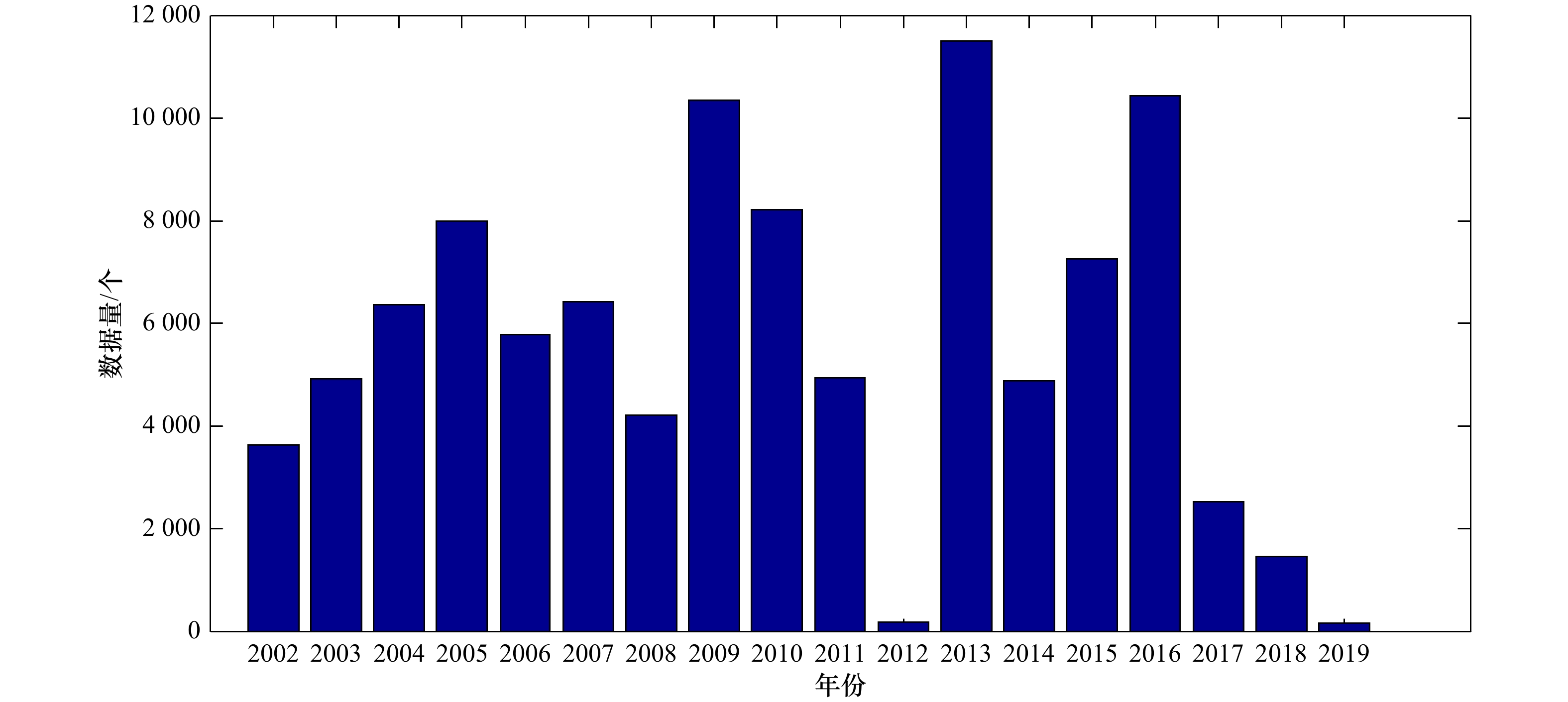
图 2 2002年至2019年5月Argo数据年分布
Fig. 2 Annual distribution of Argo data from 2002 to May, 2019
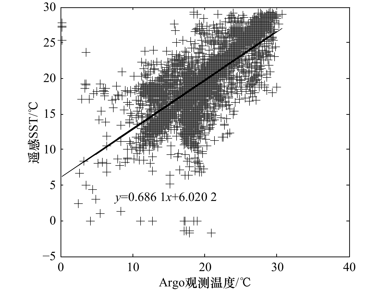
图 5 基于回归分析的遥感SST与Argo剖面最浅测量值之间的线性关系
Fig. 5 Linear relationship between remote sensing SST and the shallowest measured value of Argo profile based on regression analysis
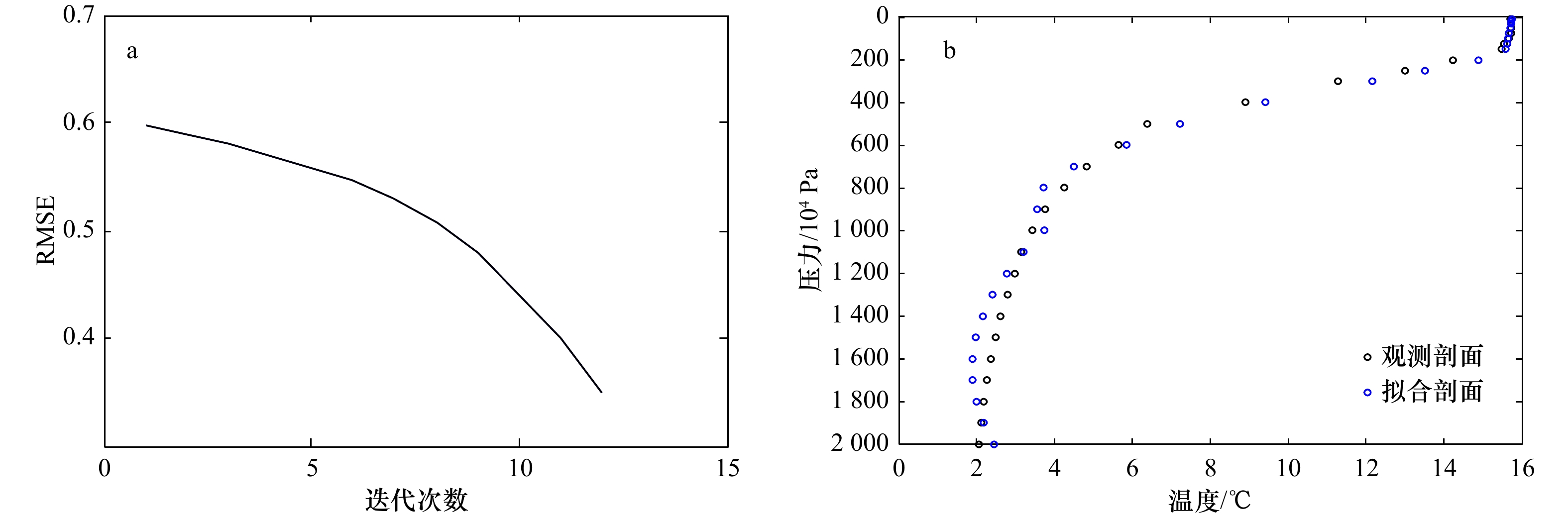
图 6 拟合结果误差分析(a),拟合结果与观测数据反应的垂直温度随深度的变化(b)
Fig. 6 Error analysis of the fitting results (a), and the vertical temperature of the fitting result and the observed data changes with depth (b)
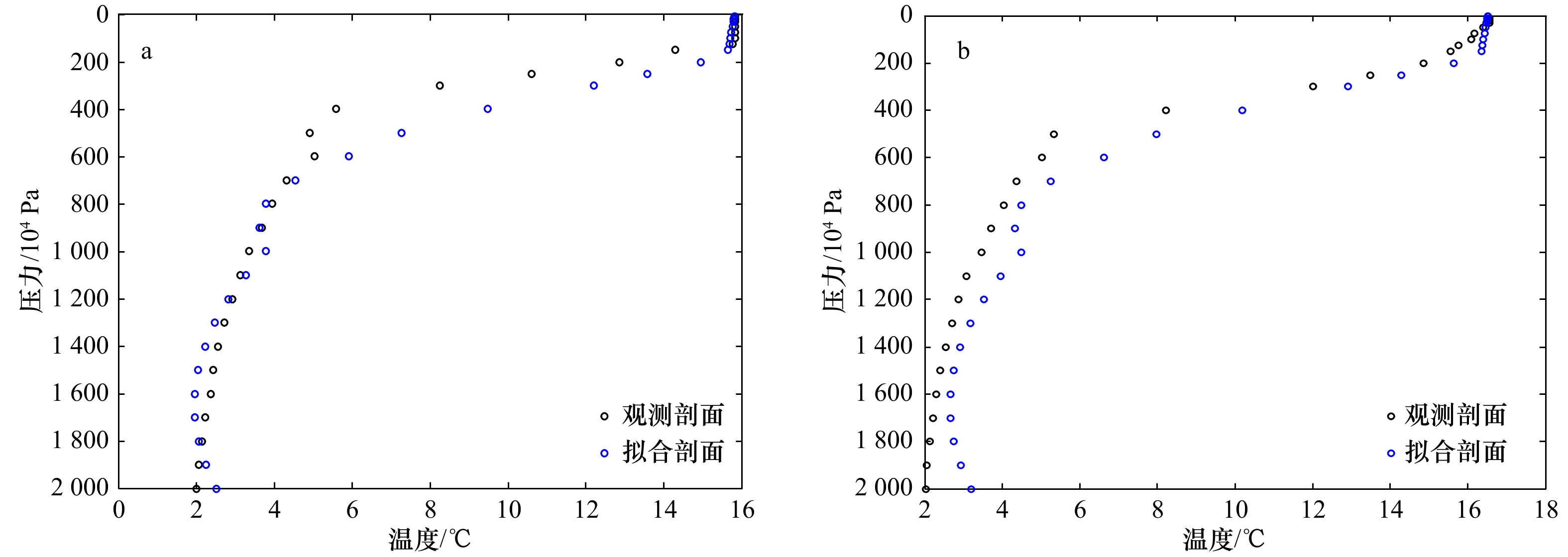
图 7 通过参数方程拟合得到的黑潮延伸体不同月份(a. 2018年2月; b. 2018年3月)拟合剖面与Argo观测剖面的对比
Fig. 7 Comparison of the Kuroshio extension body in different months (a. February 2018; b. March 2018) between the fitting profile and the Argo observation profile obtained through parametric equation fitting
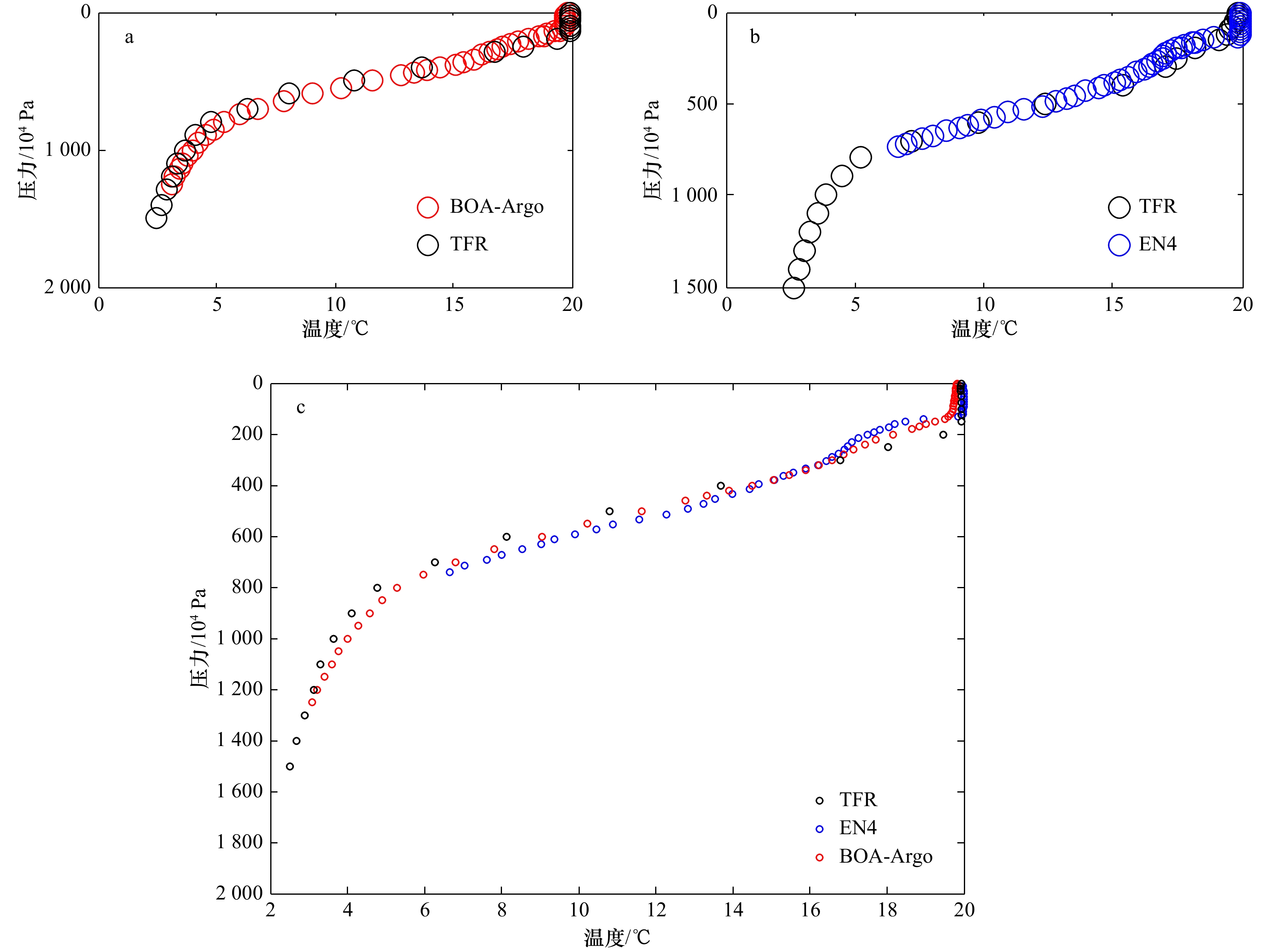
图 10 TFR结果与BOA-Argo(a),TFR结果与EN4产品(b),TFR结果与BOA-Argo、EN4产品的温度–水深散点图(c)
Fig. 10 Scatter plots between TFR results and BOA-Argo (a), TFR results and EN4 products (b), TFR results and BOA-Argo, EN4 products (c)

图 9 来自TFR、BOA-Argo和EN4数据集的表层、100×104 Pa和500×104 Pa深度的温度分布
Fig. 9 Temperature distributions at the surface, 100×104 Pa, and 500×104 Pa depths from the TFR, BOA-Argo, and EN4 datasets
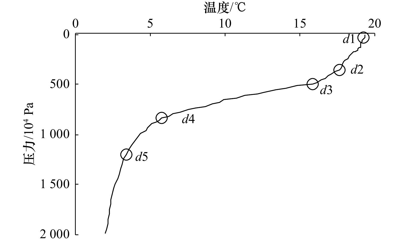
表 1 参数式中各变量名及其含义
Tab. 1 Variable names and their meanings in the parameter formula
变量 变量含义 变量 变量含义 变量 变量含义 T(m) 混合层温度 GT(m) 混合层梯度 d1 混合层深度 T(en) 夹层温度 $ {\overline G _T}^{\left( {en} \right)}$ 夹层平均梯度 d2 温跃层顶的深度 T(th) 温跃层温度 GT(th) 温跃层梯度 d3 温跃层底的深度 T(tr) 过渡层温度 $ {\overline G _T}^{\left( {tr} \right)}$ 过渡层平均梯度 d4 第一深层顶部的深度 T(de1) 第一深层温度 $ {\overline G _T}^{\left({de1} \right)}$ 第一深层平均梯度 d5 第一深层底部的深度 T(de2) 第二深层温度 ${\overline G_T}^{\left( {de2} \right)}$ 第二深层平均梯度 H 水的深度  下载: 导出CSV
-
[1] 毛庆文, 储小青, 严幼芳, 等. 南海三维动态温盐场重构系统的设计与实现[J]. 热带海洋学报, 2013, 32(6): 1−8. doi: 10.3969/j.issn.1009-5470.2013.06.001Mao Qingwen, Chu Xiaoqing, Yan Youfang, et al. A three-dimensional temperature and salinity reconstruction system in the South China Sea[J]. Journal of Tropical Oceanography, 2013, 32(6): 1−8. doi: 10.3969/j.issn.1009-5470.2013.06.001 [2] Yoon D Y, Choi H W. Development of algorithms for extracting thermocline parameters in the South Sea of Korea[J]. Ocean and Polar Research, 2012, 34(2): 265−273. doi: 10.4217/OPR.2012.34.2.265 [3] 王喜冬, 韩桂军, 李威, 等. 利用卫星观测海面信息反演三维温度场[J]. 热带海洋学报, 2011, 30(6): 10−17. doi: 10.3969/j.issn.1009-5470.2011.06.002Wang Xidong, Han Guijun, Li Wei, et al. Reconstruction of ocean temperature profile using satellite observations[J]. Journal of Tropical Oceanography, 2011, 30(6): 10−17. doi: 10.3969/j.issn.1009-5470.2011.06.002 [4] Zhou Chaojie, Ding Xiaohua, Zhang Jie, et al. An objective algorithm for reconstructing the three-dimensional ocean temperature field based on Argo profiles and SST data[J]. Ocean Dynamics, 2017, 67(12): 1523−1533. doi: 10.1007/s10236-017-1104-x [5] Hurlburt H E. The potential for ocean prediction and the role of altimeter data[J]. Marine Geodesy, 1984, 8(1/4): 17−66. doi: 10.1080/15210608409379497 [6] Thacker W C, Long R B. Fitting dynamics to data[J]. Journal of Geophysical Research: Oceans, 1988, 93(C2): 1227−1240. doi: 10.1029/JC093iC02p01227 [7] Hurlburt H E, Fox D N, Metzger E J. Statistical inference of weakly correlated subthermocline fields from satellite altimeter data[J]. Journal of Geophysical Research: Oceans, 1990, 95(C7): 11375−11409. doi: 10.1029/JC095iC07p11375 [8] Carnes M R, Mitchell J L, De Witt P W. Synthetic temperature profiles derived from Geosat altimetry: comparison with air-dropped expendable bathythermograph profiles[J]. Journal of Geophysical Research: Oceans, 1990, 95(C10): 17979−17992. doi: 10.1029/JC095iC10p17979 [9] Pascual A, Gomis D. Use of surface data to estimate geostrophic transport[J]. Journal of Atmospheric and Oceanic Technology, 2003, 20(6): 912−926. doi: 10.1175/1520-0426(2003)020<0912:UOSDTE>2.0.CO;2 [10] Carnes M R, Teague W J, Mitchell J L. Inference of subsurface thermohaline structure from fields measurable by satellite[J]. Journal of Atmospheric and Oceanic Technology, 1994, 11(2): 551−566. [11] Mitchell D A, Wimbush M, Watts D R, et al. The residual GEM technique and its application to the Southwestern Japan/East Sea[J]. Journal of Atmospheric and Oceanic Technology, 2004, 21(12): 1895−1909. doi: 10.1175/JTECH-1668.1 [12] Hao Jiajia, Chen Yongli, Feng Junqiao, et al. Reconstruction of vertical thermal structure from several subsurface temperatures in the China Seas and adjacent waters[J]. Chinese Journal of Oceanology and Limnology, 2009, 27(2): 218−228. doi: 10.1007/s00343-009-9201-4 [13] 吴新荣, 韩桂军, 张学峰, 等. 人工神经网络在南海近海面气温反演中的应用研究[J]. 热带海洋学报, 2012, 31(2): 7−14.Wu Xinrong, Han Guijun, Zhang Xuefeng, et al. Retrieving near-surface air temperature in the South China Sea using artificial neural network[J]. Journal of Tropical Oceanography, 2012, 31(2): 7−14. [14] 范秀梅, 樊伟, 杨胜龙, 等. 基于海面位势高度和海表温度构建西太平洋三维温度场[J]. 中国海洋大学学报, 2019, 49(12): 1−10.Fan Xiumei, Fan Wei, Yang Shenglong, et al. A new reconstruction method for the 3-D temperature field in the western Pacific Ocean based on steric height and SST[J]. Periodical of Ocean University of China, 2019, 49(12): 1−10. [15] 何建玲, 蔡树群. 利用Argo数据计算吕宋海峡以东海域水文特性参数和流场[J]. 热带海洋学报, 2012, 31(1): 18−27.He Jianling, Cai Shuqun. Study on the hydrological characteristic parameters and flow field east of the Luzon Strait using Argo profiling floats[J]. Journal of Tropical Oceanography, 2012, 31(1): 18−27. [16] 薛惠芬, 苗春葆, 董明媚, 等. 全球ARGO浮标及其观测资料状况分析[J]. 海洋技术, 2005, 24(4): 23−28.Xue Huifen, Miao Chunbao, Dong Mingmei, et al. Global ARGO floats and the analyses of its observation data stasus[J]. Ocean Technology, 2005, 24(4): 23−28. [17] Reynolds W R. Impact of mount pinatubo aerosols on satellite-derived sea surface temperatures[J]. Journal of Climate, 1993, 6(4): 768-774. [18] 李宏, 许建平, 刘增宏, 等. 利用逐步订正法构建Argo网格资料集的研究[J]. 海洋通报, 2012, 31(5): 502−514.Li Hong, Xu Jianping, Liu Zenghong, et al. Study on the establishment of gridded Argo data by successive correction[J]. Marine Science Bulletin, 2012, 31(5): 502−514. [19] 李宏, 许建平, 刘增宏, 等. 全球海洋Argo网格资料集及其验证[J]. 海洋通报, 2013, 32(6): 615−625.Li Hong, Xu Jianping, Liu Zenghong, et al. Study on the global ocean Argo gridded dataset and its validationcommunity in coastal waters of Yantai[J]. Marine Science Bulletin, 2013, 32(6): 615−625. [20] Chu P C, Fralick Jr C R, Haeger S D, et al. A parametric model for the Yellow Sea thermal variability[J]. Journal of Geophysical Research: Oceans, 1997, 102(C5): 10499−10507. doi: 10.1029/97JC00444 [21] Chu P C, Fan Chenwu. Exponential leap-forward gradient scheme for determining the isothermal layer depth from profile data[J]. Journal of Oceanography, 2017, 73(4): 503−526. doi: 10.1007/s10872-017-0418-0 [22] Chu P C, Fralick Jr C R, Haeger S D, et al. Reply to “Comment on ‘A parametric model for the Yellow Sea thermal variability’ by P. C. Chu et al.”[J]. Journal of Geophysical Research: Oceans, 1999, 104(C8): 18463−18466. doi: 10.1029/1999JC900173 [23] Park J H, Watts D R, Tracey K L, et al. A multi-index GEM technique and its application to the southwestern Japan/East Sea[J]. Journal of Atmospheric and Oceanic Technology, 2005, 22(8): 1282−1293. -

计量
- 文章访问数: 276
- HTML全文浏览量: 158
- PDF下载量: 34
- 被引次数: 0
