

Remote sensing monitoring of suspended sediment concentration based on GF-4 satellite in the Hangzhou Bay
-
摘要: 悬浮泥沙作为重要水质参数,其分布和动态变化对河口及近岸的生态、环境、物质循环等都具有深远的影响。我国静止轨道高分四号(GF-4)卫星数据具有高时间和高空间分辨率的观测优势,在水色遥感上具有重大应用潜力。为探究GF-4卫星对悬浮泥沙浓度的监测能力,本文以杭州湾为研究区,构建反演模型,利用静止海洋水色成像仪进行交叉验证。结果表明,以GF-4卫星第5和第4波段遥感反射率的比值作为遥感因子建立的反演模型精度较高,决定系数为0.92,均方根误差为223.2 mg/L,平均相对误差为17.2%。交叉验证结果显示,GF-4卫星作为一种新的遥感数据源,在低浓度区与静止海洋水色成像仪反演悬浮泥沙浓度分布相似,但在高浓度区的差异随浓度增高而增大,总体可满足中国大部分海区的监测需求。Abstract: As an important water quality parameter, the distribution and dynamic change of suspended sediment have a profound impact on the ecology, environment and material circulation of the estuary and the near shore. GF-4 satellite has the ability to observe at any time, can quickly provide a large number of observation data, and has the application potential in water color remote sensing. In order to explore the monitoring effect of GF-4 satellite on suspended sediment in water, takes the Hangzhou Bay as the research area in this paper, constructs suspended sediment concentration inversion model, and uses GOCI satellite to cross verify. The results show that the index model established by using the ratio of remote sensing reflectance of the 5th and 4th band of GF-4 as the remote sensing factor has a high inversion accuracy, with a determination coefficient of 0.92, a root mean square error of 273.6 mg/L and an mean relative error of 17.2%. The cross-validation results show that GF-4 satellite data, as a new remote sensing data source, is similar to the distribution of GOCI satellite inversion suspended sediment concentration in the low concentration region, but the difference increases with the increase of concentration in the high concentration region. The research shows that GF-4 satellite is suitable for high precision inversion in the waters with low suspended sediment concentration and can be applied in most marine areas of China.
-
Key words:
- suspended sediment /
- Hangzhou Bay /
- GF-4 satellite /
- GOCI satellite /
- index model
-
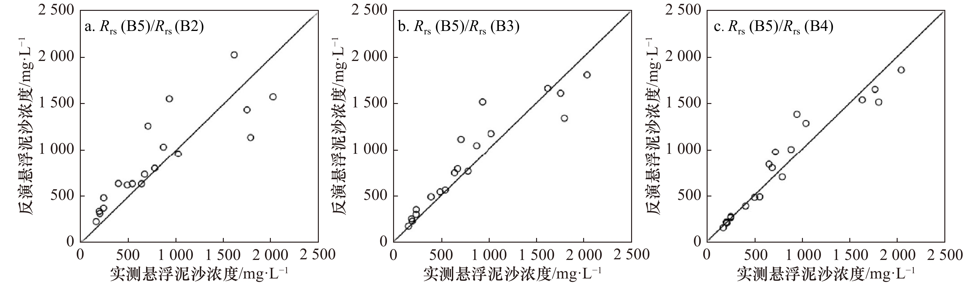
图 3 GF-4实测点与建模点悬浮泥沙浓度对比
Fig. 3 Comparison of suspended sediment concentration retrived by GF-4 satellite measured point and modeling point

图 4 GF-4(a)和GOCI(b)卫星反演悬浮泥沙浓度结果
Fig. 4 Inversion results of suspended sediment concentration retrived by GF-4 satellite (a) and GOCI satellite (b)
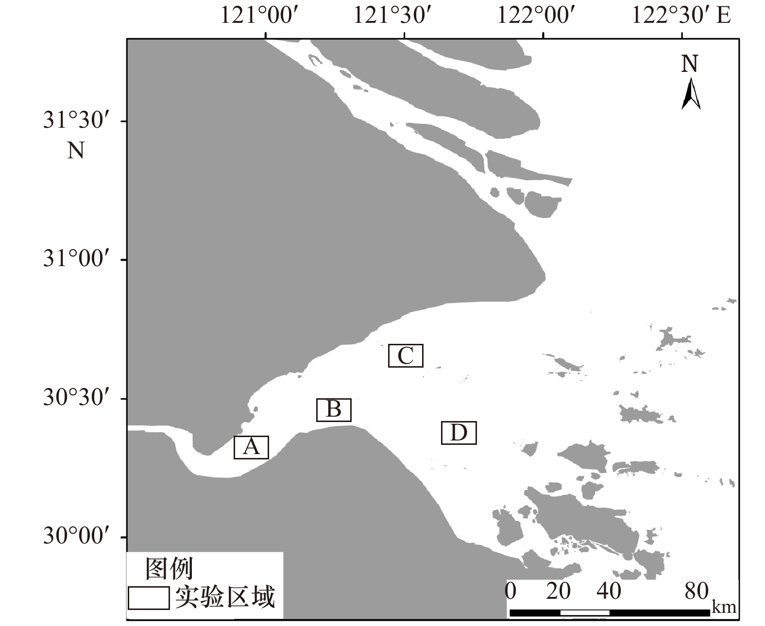
图 5 悬浮泥沙浓度反演的4个实验区域
Fig. 5 Four experimental regions for inversion of suspended sediment concentration
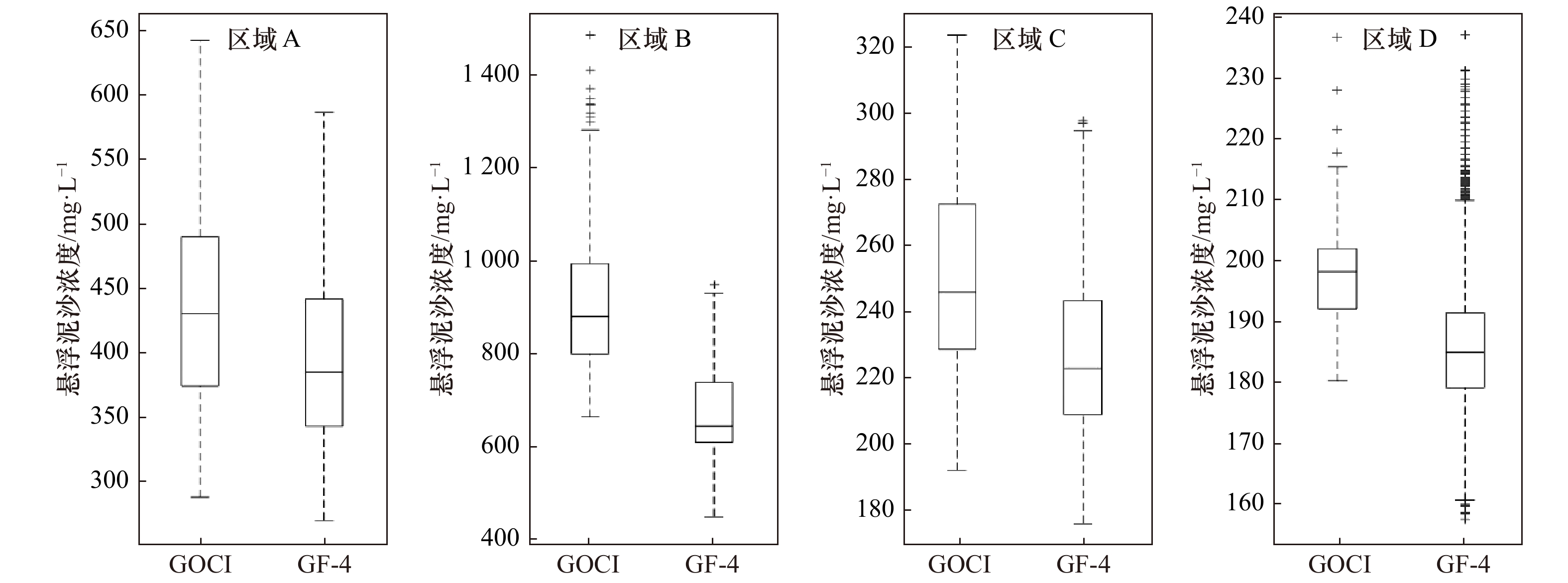
图 6 反演得到的4个实验区域的悬浮泥沙浓度箱线图
Fig. 6 Box-plot of suspended sediment concentration in four experimental regions
表 1 卫星传感器的基本参数
Tab. 1 Basic parameters of satellite sensor
传感器 轨道类型 光谱范围/nm 幅宽/km GOCI卫星 地球同步轨道 B1: 402~422 2 500 B2: 433~453 B3: 480~500 B4: 545~565 B5: 650~670 B6: 675~685 B7: 735~755 B8: 845~885 GF-4卫星 地球同步轨道 B1: 450~900 400 B2: 450~520 B3: 520~600 B4: 630~690 B5: 760~900 B6: 3 500~4 100  下载: 导出CSV
表 2 悬浮泥沙浓度反演模型误差
Tab. 2 Error of different suspended sediment concentration inversion models
传感器 遥感因子 建模点(40对) 验证点(20对) 方程 R2 RMSE/mg·L–1 MRE/% GF-4卫星 $ {R}_{\rm {rs}}\left(\mathrm{B}5\right)/{R}_{\rm {rs}}\left(\mathrm{B}2\right) $ SSC=40.29exp(1.83X) 0.82 489.7 32.0 $ {R}_{\rm {rs}}\left(\mathrm{B}5\right)/{R}_{\rm {rs}}\left(\mathrm{B}3\right) $ SSC=13.88exp(3.59X) 0.88 349.5 24.5 $ {R}_{\rm {rs}}\left(\mathrm{B}5\right)/{R}_{\rm {rs}}\left(\mathrm{B}4\right) $ SSC=4.87exp(5.63X) 0.92 223.2 17.2 GOCI卫星 $ {R}_{\rm {rs}}\left(\mathrm{B}8\right)/{R}_{\rm {rs}}\left(\mathrm{B}6\right) $ SSC=20.59exp(4.49X) 0.86 212.6 12.3
下载: 导出CSV
表 3 各区间反演模型误差
Tab. 3 Model error of interval inversion
悬浮泥沙浓度/mg·L–1 GF-4卫星模型 GOCI卫星模型 RMSE/mg·L–1 MRE/% RMSE/mg·L–1 MRE/% 0~500 26.4 13.1 22.8 12.4 500~1 000 91.7 16.0 104.6 20.0 1 000~2 000 260.8 20.6 181.9 18.7
下载: 导出CSV
表 4 杭州湾悬浮泥沙反演结果(单位:mg/L)
Tab. 4 Inversion results of suspended sediment concentration in the Hangzhou Bay(unit:mg/L)
传感器 最大值 最小值 平均值 GF-4卫星 1 248.8 54.9 171.8 GOCI卫星 1 905.9 23.5 256.8
下载: 导出CSV
表 5 杭州湾实验区域悬浮泥沙浓度(单位:mg/L)
Tab. 5 Suspended sediment concentration of experimental regions in the Hangzhou Bay (unit: mg/L)
传感器 区域A 区域B 区域C 区域D 最小值 最大值 平均值 最小值 最大值 平均值 最小值 最大值 平均值 最小值 最大值 平均值 GF-4卫星 297.3 703.3 490.5 439.5 939.3 663.4 176.8 297.1 227.9 157.3 236.5 185.9 GOCI卫星 358.3 794.0 577.7 654.4 1465.2 937.1 192.8 322.6 251.7 179.9 236.1 197.8
下载: 导出CSV
表 6 大气校正后GF-4卫星相对GOCI卫星反演的悬浮泥沙浓度平均误差
Tab. 6 Average error of suspended sediment concentration retrieved by GF-4 satellite relative to GOCI satellite after atmospheric correction
SSC浓度/mg·L−1 GF-4 B5相对GOCI B8/% GF-4 B4相对GOCI B6/% GF-4 B5、B4相对GOCI B8、B6/% <500 18.4 −1.0 23.8 500~1 000 9.0 −1.6 11.8 >1 000 5.1 −1.6 7.1
下载: 导出CSV
-
[1] 姜丽君. 基于遥感反演的近20 a莱州湾表层悬浮泥沙和叶绿素a时空变化研究[D]. 烟台: 鲁东大学, 2018.Jiang Lijun. Temporal and spatial variations of suspended sediment and chlorophyll-a in Laizhou Bay in recent 20 years based on remote sensing inversion[D]. Yantai: Ludong University, 2018. [2] 沈宏. 多源卫星数据的光谱带宽和空间尺度对水色参数遥感的影响[D]. 上海: 华东师范大学, 2012.Shen Hong. Effect of spectral bandwidth and spatial scale of mul-sensors data on remote sensing of ocean color[D]. Shanghai: East China Normal University, 2012. [3] 陈勇, 韩震, 杨丽君, 等. 长江口水体表层悬浮泥沙时空分布对环境演变的响应[J]. 海洋学报, 2012, 34(1): 145−152.Chen Yong, Han Zhen, Yang Lijun, et al. The spatial and temporal distribution of suspended sediment concentration and its response to environmental change in the Changjiang Estuary[J]. Haiyang Xuebao, 2012, 34(1): 145−152. [4] 刘艳霞, 黄海军, 杨晓阳. 基于遥感反演的莱州湾悬沙分布及其沉积动力分析[J]. 海洋学报, 2013, 35(6): 43−53.Liu Yanxia, Huang Haijun, Yang Xiaoyang. The transportation and deposition of suspended sediment and its dynamic mechanism analysis based on Landsat images in the Laizhou Bay[J]. Haiyang Xuebao, 2013, 35(6): 43−53. [5] Yu Shengyan, Mantravadi V S. Study on distribution characteristics of suspended sediment in Yellow River estuary based on remote sensing[J]. Journal of the Indian Society of Remote Sensing, 2019, 47(9): 1507−1513. doi: 10.1007/s12524-019-00985-9 [6] Lu Cuizhuo, Li Huan, Dai Weiqi, et al. 3-D simulation of the suspended sediment transport in the Jiao Jiang Estuary: Based on validating by remote sensing retrieval[J]. Journal of Coastal Research, 2018(85): 116−120. [7] Li Yangdong, Li Xiaofeng. Remote sensing observations and numerical studies of a super typhoon–induced suspended sediment concentration variation in the East China Sea[J]. Ocean Modelling, 2016, 104: 187−202. doi: 10.1016/j.ocemod.2016.06.010 [8] 李珏. 高分四号影像水体提取算法比较分析[J]. 黑龙江科技信息, 2016(29): 110.Li Jue. Comparison and analysis of water extraction algorithms in GF-4 image[J]. Heilongjiang Science and Technology Information, 2016(29): 110. [9] 刘明, 吴玮, 舒阳, 等. 基于“高分四号”卫星数据的水体提取效果评价[J]. 航天返回与遥感, 2016, 37(4): 96−101.Liu Ming, Wu Wei, Shu Yang, et al. Evaluation of water extraction based on GF-4 satellite data[J]. Spacecraft Recovery & Remote Sensing, 2016, 37(4): 96−101. [10] 宋挺, 龚绍琦, 刘军志, 等. 浑浊二类水体的高分四号卫星大气校正效果分析[J]. 光谱学与光谱分析, 2018, 38(4): 1191−1197.Song Ting, Gong Shaoqi, Liu Junzhi, et al. Performance assessment of atmospheric correction for multispectral data of GF-4 on inland case Ⅱ turbid water[J]. Spectroscopy and Spectral Analysis, 2018, 38(4): 1191−1197. [11] 陈晓英, 张杰, 崔廷伟, 等. 基于高分四号卫星的黄海绿潮漂移速度提取研究[J]. 海洋学报, 2018, 40(1): 29−38.Chen Xiaoying, Zhang Jie, Cui Tingwei, et al. Extraction of the green tide drift velocity in the Yellow Sea based on GF-4[J]. Haiyang Xuebao, 2018, 40(1): 29−38. [12] 胡耀躲, 张运林, 杨波, 等. 基于高频次GOCI数据的太湖悬浮物浓度短期动态和驱动力分析[J]. 湖泊科学, 2018, 30(4): 992−1003. doi: 10.18307/2018.0412Hu Yaoduo, Zhang Yunlin, Yang Bo, et al. Short-term dynamics and driving factors of total suspended matter concentration in Lake Taihu using high frequent geostationary ocean color imager data[J]. Journal of Lake Sciences, 2018, 30(4): 992−1003. doi: 10.18307/2018.0412 [13] 伍高燕. 基于GOCI遥感影像的长江入海口悬浮沉沙浓度反演及其时空动态分析[D]. 西安: 长安大学, 2015.Wu Gaoyan. Retrieval of suspended sediment concentration in the Yangtze Estuary and its spatiotemporal dynamics analysis based on GOCI image data[D]. Xi’an: Chang'an University, 2015. [14] 刘波, 程乾, 曾焕建, 等. 基于GOCI数据的杭州湾跨海大桥两侧水域悬浮泥沙浓度空间分异规律研究[J]. 杭州师范大学学报: 自然科学版, 2016, 15(1): 102−107.Liu Bo, Cheng Qian, Zeng Huanjian, et al. On the suspended sediment concentration distribution and diversity of the waters on both sides of Hangzhou Bay Sea–crossing bridge based on GOCI data[J]. Journal of Hangzhou Normal University: Natural Science Edition, 2016, 15(1): 102−107. [15] 杨雪飞. 基于GOCI和数值模拟的东海近岸悬浮泥沙浓度逐时变化研究[D]. 上海: 中国科学院大学, 2016.Yang Xuefei. Diurnal variation of suspended sediment concentration coupled GOCI and numerical simulation in coastal waters of the East China Sea[D]. Shanghai: University of Chinese Academy of Sciences, 2016. [16] 江彬彬, 张霄宇, 杜泳, 等. 基于GOCI的近岸高浓度悬浮泥沙遥感反演——以杭州湾及邻近海域为例[J]. 浙江大学学报: 理学版, 2015, 42(2): 220−227.Jiang Binbin, Zhang Xiaoyu, Du Yong, et al. Retrieving high concentration of suspended sediments based on GOCI: An example from coastal water around Hangzhou Bay, China[J]. Journal of Zhejiang University: Science Edition, 2015, 42(2): 220−227. [17] Lamquin N, Mazeran C, Doxaran D, et al. Assessment of GOCI radiometric products using MERIS, MODIS and field measurements[J]. Ocean Science Journal, 2012, 47(3): 287−311. doi: 10.1007/s12601-012-0029-z [18] 孙璐, 蒋锦刚, 朱渭宁. 基于GOCI影像的长江口及其邻近海域CDOM遥感反演及其日内变化研究[J]. 海洋学报, 2017, 39(9): 133−145.Sun Lu, Jiang Jin’gang, Zhu Weining. Remote sensing inversion and daily variation of CDOM based on GOCI in the Changjiang Estuary and adjacent waters[J]. Haiyang Xuebao, 2017, 39(9): 133−145. [19] 陶建峰, 蒯宇, 康彦彦, 等. 杭州湾及甬江口外海域悬沙时空动态研究[C]//第十八届中国海洋(岸)工程学术讨论会论文集(下). 北京: 海洋出版社, 2017: 370-374.Tao Jianfeng, Kuai Yu, Kang Yanyan, et al. Temporal and spatial dynamics of suspended sediment in Hangzhou Bay and Yongjiang Estuary[C]//Proceedings of the 18th China Ocean (Shore) Engineering Symposium (Part 2). Beijing: China Ocean Press, 2017: 370–374. [20] 朱为静. 杭州湾河口悬浮颗粒物介导的硝化—反硝化耦合过程微生物机理研究[D]. 杭州: 浙江大学, 2017.Zhu Weijing. Microbial mechanism of coupled nitrification-denitrification mediated by suspended particulate matter in Hangzhou Bay estuary[D]. Hangzhou: Zhejiang University, 2017. [21] 王飞, 王珊珊, 王新, 等. 杭州湾悬浮泥沙遥感反演与变化动力分析[J]. 华中师范大学学报: 自然科学版, 2014, 48(1): 112−116, 135.Wang Fei, Wang Shanshan, Wang Xin, et al. Remote sensing retrieval and dynamic driving force analysis of suspended sediment in Hangzhou Bay[J]. Journal of Huazhong Normal University: Natural Sciences, 2014, 48(1): 112−116, 135. [22] 王繁, 周斌, 徐建明, 等. 基于实测光谱的杭州湾悬浮物浓度遥感反演模式[J]. 环境科学, 2008, 29(11): 3022−3026. doi: 10.3321/j.issn:0250-3301.2008.11.005Wang Fan, Zhou Bin, Xu Jianming, et al. Remote sensing inversion mode of suspended particles concentration in Hangzhou Bay based on in situ measurement spectrum[J]. Environmental Science, 2008, 29(11): 3022−3026. doi: 10.3321/j.issn:0250-3301.2008.11.005 [23] 唐军武, 田国良, 汪小勇, 等. 水体光谱测量与分析Ⅰ: 水面以上测量法[J]. 遥感学报, 2004, 8(1): 37−44. doi: 10.11834/jrs.20040106Tang Junwu, Tian Guoliang, Wang Xiaoyong, et al. The methods of water spectra measurement and analysis Ⅰ: Above-water method[J]. Journal of Remote Sensing, 2004, 8(1): 37−44. doi: 10.11834/jrs.20040106 [24] 周虹丽, 朱建华, 韩冰, 等. 重量法测量悬浮物浓度关键技术研究[J]. 海洋技术, 2004, 23(3): 15−20. doi: 10.3969/j.issn.1003-2029.2004.03.004Zhou Hongli, Zhu Jianhua, Han Bing, et al. Research on the key technique of the analysis of suspended matter by weighting method[J]. Ocean Technology, 2004, 23(3): 15−20. doi: 10.3969/j.issn.1003-2029.2004.03.004 [25] Pan Yanqun, Shen Fang, Verhoef W. An improved spectral optimization algorithm for atmospheric correction over turbid coastal waters: A case study from the Changjiang (Yangtze) Estuary and the adjacent coast[J]. Remote Sensing of Environment, 2017, 191: 197−214. doi: 10.1016/j.rse.2017.01.013 [26] He Xianqiang, Bai Yan, Pan Delu, et al. Using geostationary satellite ocean color data to map the diurnal dynamics of suspended particulate matter in coastal waters[J]. Remote Sensing of Environment, 2013, 133: 225−239. doi: 10.1016/j.rse.2013.01.023 [27] 陈瑞瑞, 蒋雪中. 长江河口悬浮泥沙向浙闽沿岸输运近期变化的遥感分析[J]. 海洋科学, 2017, 41(3): 89−101. doi: 10.11759/hykx20160920002Chen Ruirui, Jiang Xuezhong. Analysis of suspended sediment variations from the Yangtze Estuary to Zhejiang-Fujian Provincial coastal waters using remotely sensed data[J]. Marine Sciences, 2017, 41(3): 89−101. doi: 10.11759/hykx20160920002 [28] 刘王兵, 于之锋, 周斌, 等. 杭州湾HJ CCD影像悬浮泥沙遥感定量反演[J]. 遥感学报, 2013, 17(4): 905−918.Liu Wangbing, Yu Zhifeng, Zhou Bin, et al. Assessment of suspended sediment concentration at the Hangzhou Bay using HJ CCD imagery[J]. Journal of Remote Sensing, 2013, 17(4): 905−918. [29] 张芸, 张鹰, 王晶晶. 悬浮泥沙浓度遥感反演模型研究[J]. 海洋科学, 2008, 32(5): 32−35, 56.Zhang Yun, Zhang Ying, Wang Jingjing. Analysis on the sensing model of suspended sediment concentrations[J]. Marine Sciences, 2008, 32(5): 32−35, 56. [30] Hu Yuekai, Yu Zhifeng, Zhou Bin, et al. Tidal-driven variation of suspended sediment in Hangzhou Bay based on GOCI data[J]. International Journal of Applied Earth Observation and Geoinformation, 2019, 82: 101920. doi: 10.1016/j.jag.2019.101920 [31] 叶涛焱. 杭州湾多时空尺度悬沙动力变化特征及与潮滩变化的互馈机理[D]. 杭州: 浙江大学, 2019.Ye Taoyan. The multi-scale variations of suspended sediment dynamics in Hangzhou Bay and its interaction with tidal flat variations[D]. Hangzhou: Zhejiang University, 2019. [32] 谢东风, 潘存鸿, 曹颖, 等. 近50 a来杭州湾冲淤变化规律与机制研究[J]. 海洋学报, 2013, 35(4): 121−128.Xie Dongfeng, Pan Cunhong, Cao Ying, et al. Decadal variations in the erosion/deposition pattern of the Hangzhou Bay and their mechanism in recent 50 a[J]. Haiyang Xuebao, 2013, 35(4): 121−128. [33] 李军, 朱建华, 高飞, 等. MODIS和GOCI卫星遥感反射率产品在浑浊海区交叉检验分析[J]. 海洋技术学报, 2015, 34(1): 15−20.Li Jun, Zhu Jianhua, Gao Fei, et al. Cross-check analysis on MODIS and GOCI satellite remote sensing reflectances in turbid sea areas[J]. Journal of Ocean Technology, 2015, 34(1): 15−20. -


计量
- 文章访问数: 682
- HTML全文浏览量: 184
- PDF下载量: 64
- 被引次数: 0
