

Application of the terrestrial laser scanner to the coastal boulders on the southern coast of Hainan Island
-
摘要: 海岸巨砾沉积是反映海岸极端波浪事件活动历史的重要载体,对于预测未来海洋极端水文灾害发生趋势具有重要意义。本文基于地面3D激光扫描技术,以海南岛南部海岸大东海和小东海的海岸珊瑚巨砾沉积为研究对象,使用了Riegl VZ4000地面3D激光扫描仪精确测量了这些珊瑚巨砾的体积参数,结合水文模型计算出搬运这些巨砾所需的临界起动波高和流速,重构了极端波浪事件强度,并根据沉积学和动力学对海岸珊瑚巨砾的沉积成因进行了分析。结果表明,地面3D激光扫描技术与传统测量方式相比,具有方便、快速、高精度的优势。海南岛大、小东海堆积的珊瑚巨砾沉积是由台风波浪破碎珊瑚礁平台前缘并将碎块输运到礁平台而成的,且台风的最大强度可能接近超强台风“宝霞”。本研究可为重建南海地区古风暴活动历史,揭示该地台风活动规律以及海岸极端波浪灾害的防风减灾工作提供重要科学参考信息。Abstract: Coastal boulders, with durable and easily visible, have been widely used as markers to confirm the existence and estimate the magnitude of marine hydrodynamic extreme events, which is valuable for risk prediction and coastal management. A detailed survey of large boulder accumulations was carried out at Dadonghai and Xiaodonghai sites on the southern coast of Hainan Island. The size, position and distance from the shoreline of 24 boulders were measured by Riegl VZ4000 3D terrestial laser (TLS) scanner and traditional methods, respectively, in order to determine their volume parameters, mass as well as the conditions under which they were transported landward to their present positions. The results were then analyzed with hydrodynamic models to evaluate the characteristics of the transporting waves and flow speeds. Storm waves would be responsible for the detachment and transportation of these largest boulders. The maximum intensity of typhoon hitting this area should not be less than that of super Typhoon Baoxia. The results indicate that the TLS technology has the advantages of convenience, speed and accuracy to measure hydrodynamic process of coastal boulders than that of traditional methods. The study insists on the potential for reconstructing the history of paleostorm activity in the South China Sea and predicting the occurrence trend of marine extreme wave disasters in the coastal areas of Hainan Island in the future.
-
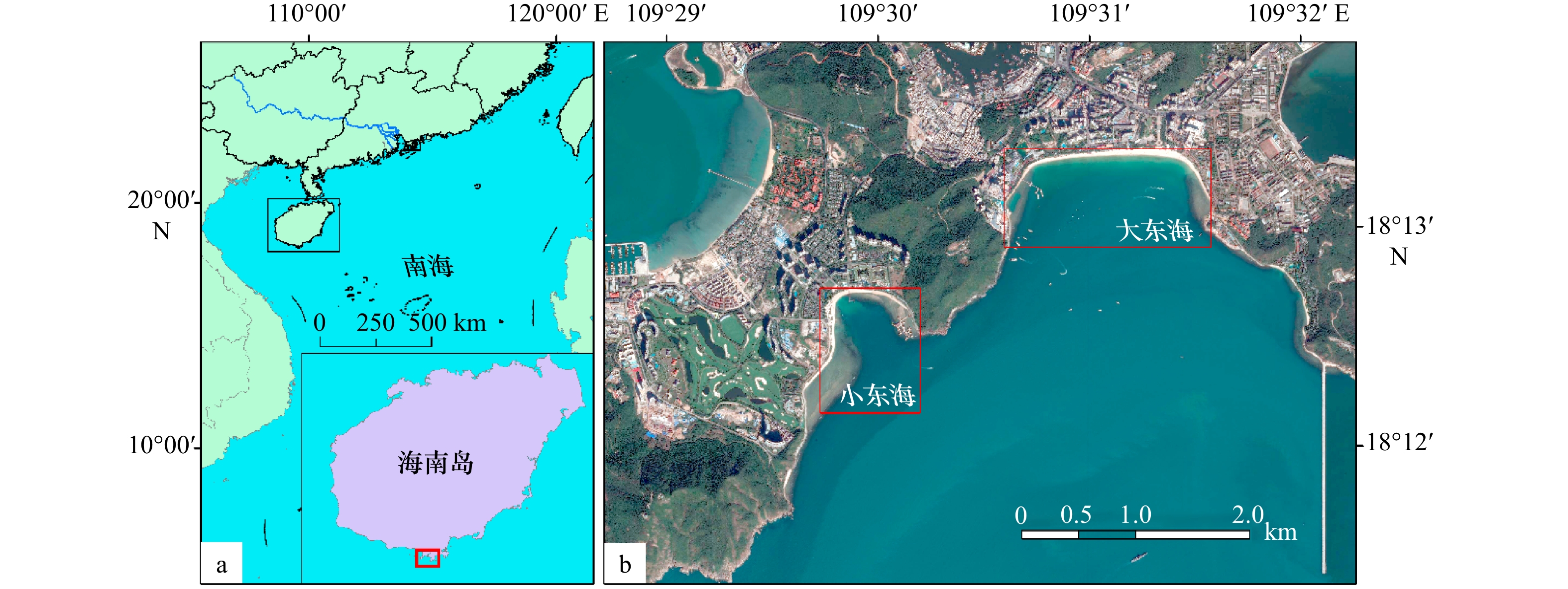
图 1 海南岛南部大、小东海研究地点(a)和大、小东海采样位置(b)
底图来自Google Earth
Fig. 1 Study area (a) and research locations (b) of Dadonghai and Xiadonghai in southern coast of Hainan Island
The base map is from Google Earth
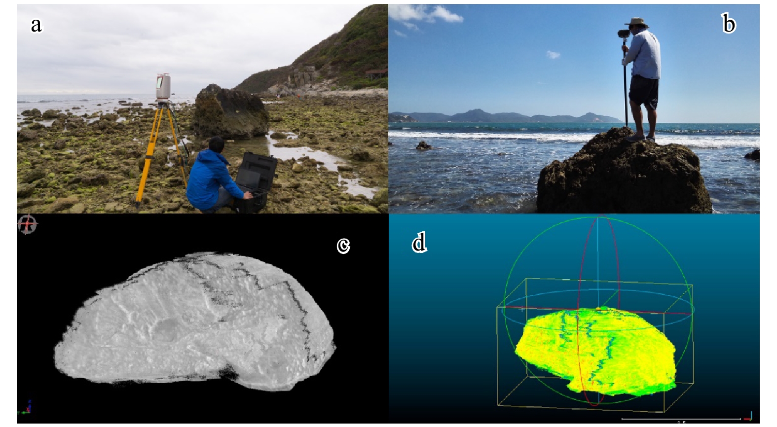
图 2 扫描仪工作(a);GPS-RTK工作情形(b);3D“点云”模型(c);基于SD点云数据进行巨砾体积参数计算(d)
Fig. 2 The terrestrial laser scan (a) and GPS-RTK (b); 3D point cloud model (c); calculation of volume parameters of boulders with 3D view of a cloud of points (d)
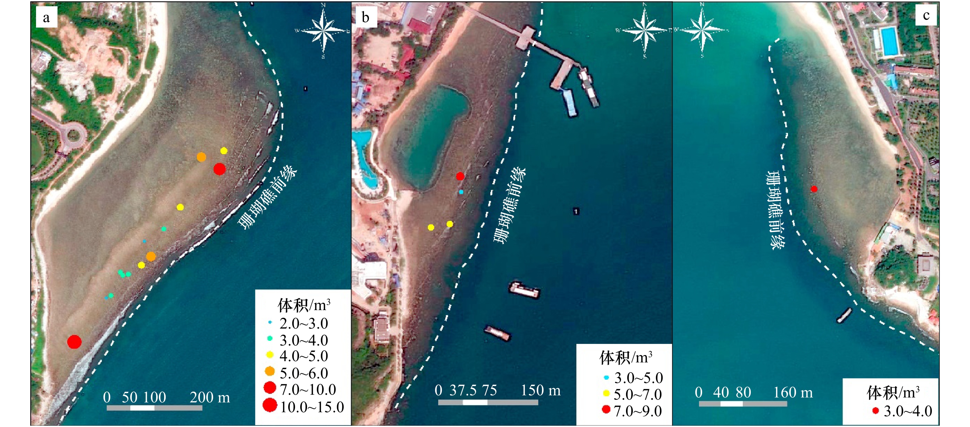
图 3 小东海巨砾分布(a);大东海西侧巨砾分布(b);大东海东侧巨砾分布(c)
底图来自Google Earth
Fig. 3 Distribution of boulders in Xiaodonghai (a), distribution of boulders on the west side of Dadonghai (b), distribution of boulders on the east side of Dadonghai (c)
The base map is from Google Earth

图 4 不同输运模式巨砾起动所需流速对比
Fig. 4 Comparison of velocity required for boulder transportation in different transport modes

图 5 传统方法和TLS技术计算体积对比
Fig. 5 Volume comparison between traditional methods and TLS techniques

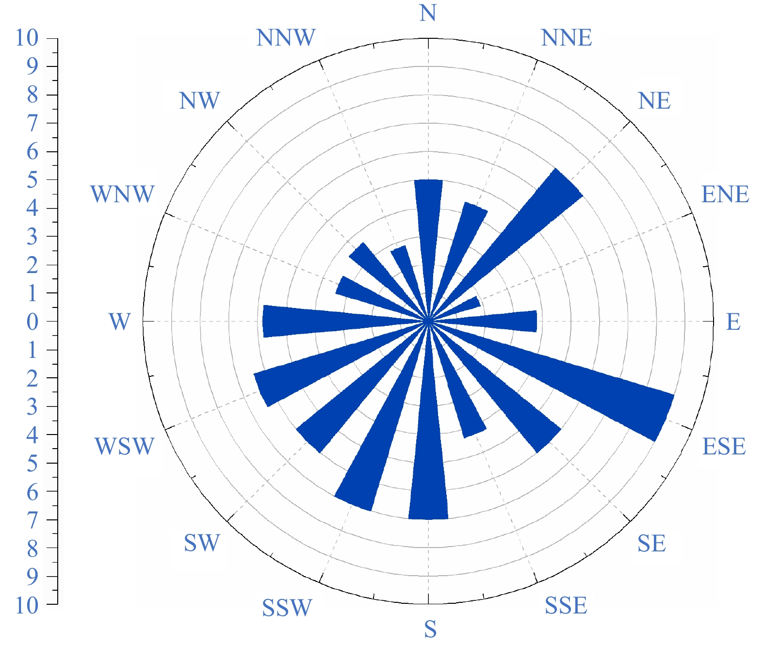
图 7 三亚湾累年各向最大波高分布(莺歌海海洋站)
Fig. 7 Annual maximum wave height distribution in Sanya Bay (data from Yinggehai Marine Station)
表 1 巨砾起动的波高
Tab. 1 Wave height required for boulders transportation
初始位置 水动力环境 海啸 台风 浸没 $H \geqslant \dfrac{{a\left( {{\rho _s} - {\rho _w}} \right) / {\rho _w}}}{{{C_d}\left( {ac / {b^2}} \right) + {C_l}}}$ $H \geqslant \dfrac{{2a\left( {{\rho _s} - {\rho _w}} \right) / {\rho _w}}}{{{C_d}\left( {ac / {b^2}} \right) + {C_l}}}$ 暴露 $H \geqslant \dfrac{{0.5a\left( {{\rho _s} - {\rho _w}} \right)/{\rho _{{w}}} - {C_m}\left( {a/b} \right)\left( {{\ddot{u}} /g} \right)}}{{{C_d}\left( {ac/{b^2}} \right) + {C_l}}}$ $H \geqslant \dfrac{{2a\left( {{\rho _s} - {\rho _w}} \right)/{\rho _{{w}}} - 4{C_m}\left( {a/b} \right)\left( {{\ddot{u}} /g} \right)}}{{{C_d}\left( {ac/{b^2}} \right) + {C_l}}}$ 交错镶嵌 $H \geqslant \dfrac{{0.25a\left( {{\rho _s} - {\rho _w}} \right)/{\rho _w}}}{{{C_l}}}$ $H \geqslant \dfrac{{a\left( {{\rho _s} - {\rho _w}} \right)/{\rho _w}}}{{{C_l}}}$  下载: 导出CSV
表 2 巨砾起动的流速
Tab. 2 Flow velocity required for coral boulders transportation
搬运方式 初始位置 地表 交错镶嵌 滑动 ${u^2} \geqslant \dfrac{{2({\rho _s}/{\rho _w} - 1)gc({\mu _s}\cos\theta + \sin\theta )}}{{{C_d}(c/b) + {\mu _s}{C_l}}}$ 无 滚动 ${u^2} \geqslant \dfrac{{2({\rho _s}/{\rho _w} - 1)gc[\cos\theta + (c/b)\sin\theta ]}}{{{C_d}({c^2}/{b^2}) + {C_l}}}$ 无 跃移 ${u^2} \geqslant \dfrac{{2({\rho _s}/{\rho _w} - 1)gc\cos\theta }}{{{C_l}}}$ ${u^2} \geqslant \dfrac{{2({\rho _s}/{\rho _w} - 1)gc(\cos\theta + {\mu _s}\sin \theta )}}{{{C_l}}}$
下载: 导出CSV
表 3 TLS技术与传统方法测量海岸珊瑚巨砾参数结果对比
Tab. 3 Comparison of parameters, weight estimation and calculation of boulders taking traditional axes and TLS measurements
巨砾编号 a轴长度/m b轴长度/m c轴长度/m V1/m3 V2/m3 Dr/m M/kg TLS 传统方法 TLS 传统方法 TLS 传统方法 DDHE_01 2.32 2.56 1.76 1.72 1.17 0.81 3.80 1.87 37.39 6 916 DDHW_01 3.59 3.37 2.61 2.24 1.72 1.67 7.52 6.60 46.68 13 686 DDHW_02 2.64 2.92 2.18 2.09 1.45 1.21 5.70 3.87 47.79 10 374 DDHW_03 1.95 1.95 1.92 1.92 1.12 0.72 3.44 1.41 44.67 6 261 DDHW_04 2.80 2.56 2.53 1.92 1.58 1.53 5.79 3.94 63.18 10 538 XDH_01 2.94 3.15 2.58 2.86 2.11 2.51 10.89 11.84 64.58 19 820 XDH_02 1.83 1.75 1.82 1.57 1.18 1.18 2.70 1.70 53.78 4 914 XDH_03 2.15 1.65 1.72 1.49 1.19 1.23 3.50 1.58 46.53 6 370 XDH_04 1.63 1.56 1.34 1.41 1.21 1.03 2.19 1.19 47.59 3 986 XDH_05 1.88 2.88 1.67 1.67 1.22 1.27 3.07 3.20 40.23 5 587 XDH_06 2.53 2.64 2.44 2.33 1.67 1.52 4.74 4.90 31.80 8 627 XDH_07 2.29 1.97 1.85 1.77 1.19 1.36 3.64 2.48 49.24 6 625 XDH_08 2.48 2.54 2.30 1.91 1.51 1.82 3.48 4.62 43.08 6 334 XDH_09 3.47 3.36 1.93 1.80 1.39 1.51 3.56 4.78 57.10 6 479 XDH_10 2.15 2.51 1.91 2.06 1.27 1.42 2.39 3.84 70.63 4 350 XDH_11 2.83 2.77 2.46 2.18 1.64 1.74 5.14 5.50 32.58 9 355 XDH_12 2.48 2.59 2.46 2.14 1.61 1.43 4.63 4.15 37.15 8 427 XDH_1314 3.12 3.66 2.47 2.22 1.17 1.37 5.32 5.83 39.42 9 682 XDH_15 2.61 2.58 2.25 2.14 1.54 1.53 3.97 4.42 57.15 7 225 XDH_16 3.34 3.31 2.23 2.19 1.48 1.47 4.97 5.58 71.94 9 045 XDH_17 2.72 2.62 2.61 1.62 1.61 1.74 5.87 3.87 116.03 10 683 XDH_18 3.10 3.15 2.22 2.31 1.31 1.41 4.22 5.37 84.24 7 680 XDH_19 3.16 3.04 3.02 2.41 1.62 1.33 7.57 5.10 71.97 13 777 注:XDH表示采样于小东海;DDH表示采样于大东海;V1为TLS技术计算的体积;V2为传统方法测量计算的体积;Dr为巨砾到珊瑚礁平台前缘的距离;M为质量;其中编号为XDH_13,XDH_14的海岸珊瑚巨砾由于层叠堆积在一起无法分离测量,将其按一块计算。
下载: 导出CSV
表 4 海岸珊瑚巨砾起动波高
Tab. 4 Wave height required to coastal coral boulders transportation
巨砾编号 水动力环境 起动波高/m 初始状态(浸没) 初始状态(暴露) 初始状态(镶嵌) TLS技术 传统方法 TLS技术 传统方法 TLS技术 传统方法 DDHE_01 海啸 0.94 1.27 0.34 0.45 2.56 2.82 台风 1.89 2.54 1.36 1.78 10.22 11.28 DDHW_01 海啸 1.41 1.09 0.64 0.46 3.95 3.71 台风 2.83 2.18 2.57 1.85 15.82 14.85 DDHW_02 海啸 1.16 1.28 0.48 0.52 2.91 3.22 台风 2.31 2.55 1.92 2.06 11.63 12.87 DDHW_03 海啸 1.12 1.63 0.43 0.61 2.15 2.15 台风 2.24 3.26 1.70 2.42 8.59 8.59 DDHW_04 海啸 1.41 0.87 0.63 0.34 3.08 2.82 台风 2.81 1.74 2.50 1.35 12.34 11.28 XDH_01 海啸 1.13 1.17 0.51 0.55 3.24 3.47 台风 2.26 2.34 2.04 2.21 12.95 13.88 XDH_02 海啸 0.97 0.74 0.35 0.24 2.02 1.93 台风 1.94 1.48 1.42 0.96 8.06 7.71 XDH_03 海啸 0.88 0.65 0.57 0.20 2.37 1.82 台风 1.77 1.29 2.29 0.80 9.47 7.27 XDH_04 海啸 0.54 0.68 0.35 0.20 1.80 1.72 台风 1.08 1.36 1.40 0.79 7.18 6.87
下载: 导出CSV
-
[1] 李佳英, 薛建军, 王维国, 等. 2013年国外重大台风灾害分析与启示[J]. 气象与减灾研究, 2014, 37(2): 50−54.Li Jiaying, Xue Jianjun, Wang Weiguo, et al. Analysis and enlightenment of the overseas important typhoon disaster in 2013[J]. Meteorology and Disaster Reduction Research, 2014, 37(2): 50−54. [2] Serreze M C, Walsh J E, Chapin III F S, et al. Observational evidence of recent change in the northern high-latitude environment[J]. Climatic Change, 2000, 46(1/2): 159−207. doi: 10.1023/A:1005504031923 [3] McGranahan G, Balk D, Anderson B. The rising tide: assessing the risks of climate change and human settlements in low elevation coastal zones[J]. Environment and Urbanization, 2007, 19(1): 17−37. doi: 10.1177/0956247807076960 [4] 廖淦标, 范代读. 全球变暖是否导致台风增强: 古风暴学研究进展与启示[J]. 科学通报, 2008, 53(19): 2907−2922.Liu K B, Fan Daidu. Perspectives on the linkage between typhoon activity and global warming from recent research advances in paleotempestology[J]. Chinese Science Bulletin, 2008, 53(19): 2907−2922. [5] Frohlich C, Hornbach M J, Taylor F W, et al. Huge erratic boulders in Tonga deposited by a prehistoric tsunami[J]. Geology, 2009, 37(2): 131−134. doi: 10.1130/G25277A.1 [6] Terry J P, Lau A Y A, Etienne S. Outlook for boulder studies within tropical geomorphology and coastal hazard research[M]//Terry J P, Lau A Y A, Etienne S. Reef-Platform Coral Boulders. Singapore: Springer, 2013: 97–102. [7] Morton R A, Gelfenbaum G, Jaffe B E. Physical criteria for distinguishing sandy tsunami and storm deposits using modern examples[J]. Sedimentary Geology, 2007, 200(3/4): 184−207. [8] Hall A M, Hansom J D, Williams D M, et al. Distribution, geomorphology and lithofacies of cliff-top storm deposits: examples from the high-energy coasts of Scotland and Ireland[J]. Marine Geology, 2006, 232(3/4): 131−155. [9] Spiske M, Böröcz Z, Bahlburg H. The role of porosity in discriminating between tsunami and hurricane emplacement of boulders--a case study from the Lesser Antilles, southern Caribbean[J]. Earth and Planetary Science Letters, 2008, 268(3/4): 384−396. [10] Goto K, Okada K, Imamura F. Characteristics and hydrodynamics of boulders transported by storm waves at Kudaka Island, Japan[J]. Marine Geology, 2009, 262(1/4): 14−24. [11] Etienne S, Paris R. Boulder accumulations related to storms on the south coast of the Reykjanes Peninsula (Iceland)[J]. Geomorphology, 2010, 114(1/2): 55−70. [12] Terry J P, Dunne K, Jankaew K. Prehistorical frequency of high-energy marine inundation events driven by typhoons in the Bay of Bangkok (Thailand), interpreted from coastal carbonate boulders[J]. Earth Surface Processes and Landforms, 2016, 41(4): 553−562. doi: 10.1002/esp.3873 [13] Nandasena N A K, Paris R, Tanaka N. Reassessment of hydrodynamic equations: minimum flow velocity to initiate boulder transport by high energy events (storms, tsunamis)[J]. Marine Geology, 2011, 281(1/4): 70−84. [14] Kennedy A B, Mori N, Yasuda T, et al. Extreme block and boulder transport along a cliffed coastline (Calicoan Island, Philippines) during Super Typhoon Haiyan[J]. Marine Geology, 2017, 383: 65−77. doi: 10.1016/j.margeo.2016.11.004 [15] Bryant E A, Young R W, Price D M. Evidence of tsunami sedimentation on the southeastern coast of Australia[J]. The Journal of Geology, 1992, 100(6): 753−765. doi: 10.1086/629626 [16] Bryant E A, Young R W, Price D M, et al. The impact of tsunami on the coastline of Jervis Bay, southeastern Australia[J]. Physical Geography, 1997, 18(5): 440−459. doi: 10.1080/02723646.1997.10642629 [17] Nott J. Extremely high-energy wave deposits inside the Great Barrier Reef, Australia: determining the cause-tsunami or tropical cyclone[J]. Marine Geology, 1997, 141(1/4): 193−207. [18] May S M, Engel M, Brill D, et al. Block and boulder transport in eastern Samar (Philippines) during Supertyphoon Haiyan[J]. Earth Surface Dynamics, 2015, 3(4): 543−558. doi: 10.5194/esurf-3-543-2015 [19] Erdmann W, Kelletat D, Scheffers A. Boulder transport by storms-extreme-waves in the coastal zone of the Irish west coast[J]. Marine Geology, 2018, 399: 1−13. doi: 10.1016/j.margeo.2018.02.003 [20] Terry J P, Jankaew K, Dunne K. Coastal vulnerability to typhoon inundation in the Bay of Bangkok, Thailand? Evidence from carbonate boulder deposits on Ko Larn Island[J]. Estuarine, Coastal and Shelf Science, 2015, 165: 261−269. doi: 10.1016/j.ecss.2015.05.028 [21] Maouche S, Morhange C, Meghraoui M. Large boulder accumulation on the Algerian coast evidence tsunami events in the western Mediterranean[J]. Marine Geology, 2009, 262(1/4): 96−104. [22] Switzer A D, Burston J M. Competing mechanisms for boulder deposition on the southeast Australian coast[J]. Geomorphology, 2010, 114(1/2): 42−54. [23] 马立广. 地面三维激光扫描测量技术研究[D]. 武汉: 武汉大学, 2005.Ma Liguang. The research of terrestrial laser scanning technology[D]. Wuhan: Wuhan University, 2005. [24] Rosser N J, Petley D N, Lim M, et al. Terrestrial laser scanning for monitoring the process of hard rock coastal cliff erosion[J]. Quarterly Journal of Engineering Geology and Hydrogeology, 2005, 38(4): 363−375. doi: 10.1144/1470-9236/05-008 [25] 谢卫明, 何青, 章可奇, 等. 三维激光扫描系统在潮滩地貌研究中的应用[J]. 泥沙研究, 2015(1): 1−6.Xie Weiming, He Qing, Zhang Keqi, et al. Application of the terrestrial laser scanner to measuring geomorphology in tidal flats and salt marshes[J]. Journal of Sediment Research, 2015(1): 1−6. [26] 王春晓, 纪育强, 孙强, 等. 三维激光扫描技术在海洋模型试验中的应用[J]. 海岸工程, 2013, 32(2): 55−62. doi: 10.3969/j.issn.1002-3682.2013.02.007Wang Chunxiao, Ji Yuqiang, Sun Qiang, et al. Application of 3D laser scanning technology to the marine model test[J]. Coastal Engineering, 2013, 32(2): 55−62. doi: 10.3969/j.issn.1002-3682.2013.02.007 [27] Olsen M J, Cheung K F, Yamazaki Y, et al. Damage assessment of the 2010 Chile earthquake and tsunami using terrestrial laser scanning[J]. Earthquake Spectra, 2012, 28(S1): S179−S197. doi: 10.1193/1.4000021 [28] Donoghue D N M, Watt P J, Cox N J, et al. Remote sensing of species mixtures in conifer plantations using LiDAR height and intensity data[J]. Remote Sensing of Environment, 2007, 110(4): 509−522. doi: 10.1016/j.rse.2007.02.032 [29] Calders K, Newnham G, Burt A, et al. Nondestructive estimates of above-ground biomass using terrestrial laser scanning[J]. Methods in Ecology and Evolution, 2015, 6(2): 198−208. doi: 10.1111/2041-210X.12301 [30] 梁海萍, 梁海燕, 车志伟, 等. 近五十年登陆海南省的热带气旋统计特征分析[J]. 海洋预报, 2015, 32(4): 68−74. doi: 10.11737/j.issn.1003-0239.2015.04.008Liang Haiping, Liang Haiyan, Che Zhiwei, et al. A statistical analysis of landfall tropical cyclone in fifty years in Hainan Province[J]. Marine Forecasts, 2015, 32(4): 68−74. doi: 10.11737/j.issn.1003-0239.2015.04.008 [31] 张明书, 刘键, 李浩, 等. 海南岛周缘珊瑚礁的基本特征和成礁时代[J]. 海洋地质与第四纪地质, 1990, 10(2): 25−43.Zhang Mingshu, Liu Jian, Li Hao, et al. Basic characteristics and formation time of peripheral coral reefs in Hainan Island[J]. Marine Geology and Quaternary Geology, 1990, 10(2): 25−43. [32] 吕炳全, 王国忠, 全松青. 海南岛珊瑚岸礁的特征[J]. 地理研究, 1984, 3(3): 1−16.Lü Bingquan, Wang Guozhong, Quan Songqing. The characteristics of fringing reefs of Hainan Island[J]. Geographical Research, 1984, 3(3): 1−16. [33] 王颖. 海南岛海岸环境特征[J]. 海洋地质前沿, 2002, 18(3): 1−9.Wang Ying. Features of Hainan Island coastal environment[J]. Marine Geology Letters, 2002, 18(3): 1−9. [34] 毛龙江, 张永战, 魏灵, 等. 海南岛三亚湾海滩研究[J]. 第四纪研究, 2006, 26(3): 477−484. doi: 10.3321/j.issn:1001-7410.2006.03.020Mao Longjiang, Zhang Yongzhan, Wei Ling, et al. Study on beach characteristics in Sanya area of Hainan Island[J]. Quaternary Sciences, 2006, 26(3): 477−484. doi: 10.3321/j.issn:1001-7410.2006.03.020 [35] Nott J. Waves, coastal boulder deposits and the importance of the pre-transport setting[J]. Earth and Planetary Science Letters, 2003, 210(1/2): 269−276. [36] Lorang M S. A wave-competence approach to distinguish between boulder and megaclast deposits due to storm waves versus tsunamis[J]. Marine Geology, 2011, 283(1/4): 90−97. [37] Scheffers A, Kelletat D. Sedimentologic and geomorphologic tsunami imprints worldwide: a review[J]. Earth-Science Reviews, 2003, 63(1/2): 83−92. [38] Engel M, May S M. Bonaire's boulder fields revisited: evidence for Holocene tsunami impact on the Leeward Antilles[J]. Quaternary Science Reviews, 2012, 54: 126−141. doi: 10.1016/j.quascirev.2011.12.011 [39] Hoffmeister D, Ntageretzis K, Aasen H, et al. 3D model-based estimations of volume and mass of high-energy dislocated boulders in coastal areas of Greece by terrestrial laser scanning[J]. Zeitschrift für Geomorphologie, 2014, 58(3): 115−135. doi: 10.1127/0372-8854/2013/S-00126 [40] 尹洪强. 基于SWAN模式下南海台风浪的推算[D]. 大连: 大连理工大学, 2014.Yin Hongqiang. Typhoon wave forecast in the South Sea by SWAN model[D]. Dalian: Dalian University of Technology, 2014. [41] 周良明, 吴伦宇, 郭佩芳, 等. 应用WAVEWATCH-Ⅲ模式对南海的波浪场进行数值计算、统计分析和研究[J]. 热带海洋学报, 2007, 26(5): 1−8. doi: 10.3969/j.issn.1009-5470.2007.05.001Zhou Liangming, Wu Lunyu, Guo Peifang, et al. Simulation and study of wave in South China Sea using WAVEWATCH-Ⅲ[J]. Journal of Tropical Oceanography, 2007, 26(5): 1−8. doi: 10.3969/j.issn.1009-5470.2007.05.001 [42] Liu Y, Santos A, Wang S M, et al. Tsunami hazards along Chinese coast from potential earthquakes in South China Sea[J]. Physics of the Earth and Planetary Interiors, 2007, 163(1/4): 233−244. [43] 周亮, 高抒, 杨阳, 等. 海南岛东南部海湾350年古风暴事件沉积与历史文献记录对比[J]. 海洋学报, 2015, 37(9): 84−94. doi: 10.3969/j.issn.0253-4193.2015.09.009Zhou Liang, Gao Shu, Yang Yang, et al. Comparison of paleostorm events between sedimentary and historical archives: a 350 year record from southeastern Hainan Island coastal embayments[J]. Haiyang Xuebao, 2015, 37(9): 84−94. doi: 10.3969/j.issn.0253-4193.2015.09.009 [44] Goto K, Miyagi K, Kawana T, et al. Emplacement and movement of boulders by known storm waves-field evidence from the Okinawa Islands, Japan[J]. Marine Geology, 2011, 283(1/4): 66−78. [45] Hongo C, Kurihara H, Golbuu Y. Coral boulders on Melekeok reef in the Palau Islands: an indicator of wave activity associated with tropical cyclones[J]. Marine Geology, 2018, 399: 14−22. doi: 10.1016/j.margeo.2018.02.004 -

 点击查看大图
计量
- 文章访问数: 269
- HTML全文浏览量: 15
- PDF下载量: 101
- 被引次数: 0
