

Study on the properties and exchanges of water masses in the region of Antarctic Peninsula
-
摘要: 利用中国第34次南极考察于2018年1–2月在南极半岛周边海域获得的温盐、海流现场观测数据,分析了调查区域主要水团及水交换特征。结果表明,观测区域内主要存在南极表层水、绕极深层水、暖深层水、南极底层水、布兰斯菲尔德海峡底层水。威德尔海的暖深层水、威德尔海深层水通过南奥克尼海台东侧的奥克尼通道、布鲁斯通道和南奥克尼海台西侧的埃斯佩里兹通道进入斯科舍海,其中奥克尼通道的深层海流最强,流速最大可达0.25 m/s,密度较大的威德尔海深层水可以通过此通道进入斯科舍海;布鲁斯通道海流流速约为0.13 m/s,通过此通道的暖深层水位势温度较高;埃斯佩里兹通道海流流速约为0.10 m/s,通过此通道的暖深层水位势温度最低,威德尔海深层水密度最小。在南奥克尼海台东西两侧均观测到南向和北向的海流,但整体上来看,向北的海流和水交换更强。水体进入斯科舍海后,沿着南斯科舍海岭的北侧向西北方向流动,流速约为0.21 m/s。德雷克海峡中的南极绕极流仅有一部分向东进入斯科舍海南部海域,且受到向西流动的暖深层水、威德尔海深层水的影响,斯科舍海南部海域的绕极深层水明显比德雷克海峡中绕极深层水的高温高盐性质弱;受到南极绕极流的影响,南斯科舍海岭北侧的威德尔海深层水比南侧暖。南斯科舍海岭上的水体可能受到北侧绕极深层水、暖深层水,西侧陆架水,东侧冬季水的影响,因此海岭上水体结构较为复杂。Abstract: Based on the 34th Chinese Antarctic scientific expedition "Xiangyanghong 01" cruise around the Antarctic Peninsula from January to February 2018, the properties and exchanges of water masses in the region of Antarctic Peninsula were analyzed. The main water masses are Antarctic Surface Water, Circumpolar Deep Water, Warm Deep Water, Antarctic Bottom Water, Bransfield Srait Bottom Water. Weddell Sea Warm Deep Water and Weddell Sea Deep Water flow into Scotia Sea through the Orkney Passage, the Bruce Passage on the east of the South Orkney Plateau and the Hesperides Gap on the west of the South Orkney Plateau. Among them, the deepest current velocity is 0.25 m/s in Orkney Passage, which allow denser Weddell Sea Deep Water to flow to Scotia Sea; the current velocity is 0.13 m/s in Bruce Passage, which allow warmer Warm Deep Water flows and the temperature of Warm Deep Water passing through this gap is the lowest, and the current velocity is 0.10 m/s in Hesperides Gap, only colder Warm Deep Water and lighter Weddell Sea Deep Water can pass. Southward currents and northward currents were observed on both sides of the South Orkney Plateau, but northward currents and water exchange are stronger. Water flow westward along the north side of the South Scotia Ridge after entering the Scotia Sea through the Passages on both sides of the South Orkney Plateau, with a velocity of 0.21 m/s. A branch of Antarctic Circumpolar Current in Drake Passage flow eastward to Scotia Sea, and influenced by Warm Deep Water and Weddell Sea Deep Water flowing westward, Circumpolar Deep Water in the Scotia Sea is obviously weaker than that in the Drake Passage. Affected by the eastward Antarctic Circumpolar Current, Weddell Sea Deep Water on the north side of the South Scotia Ridge is warmer than that on the south side. The water on the South Scotia Ridge may be affected by the Circumpolar Deep Water and Warm Deep Water in the north, Shelf Water in the West and Winter Water in the east, so the structure of the water on the South Scotia Ridge is much complex.
-
Key words:
- water mass /
- exchange of water mass /
- Antarctic Peninsula /
- Weddell Sea /
- circulation
-

图 1 南极半岛周边海域地形及观测站位
圆点位置表示CTD观测站位,圆点颜色表示观测时间,标记在图下方
Fig. 1 Topography around the Antarctic Peninsula and observation stations
The dots position represents the position of CTD observation stations, and the color of dots represents the observation time which is marked below the figure
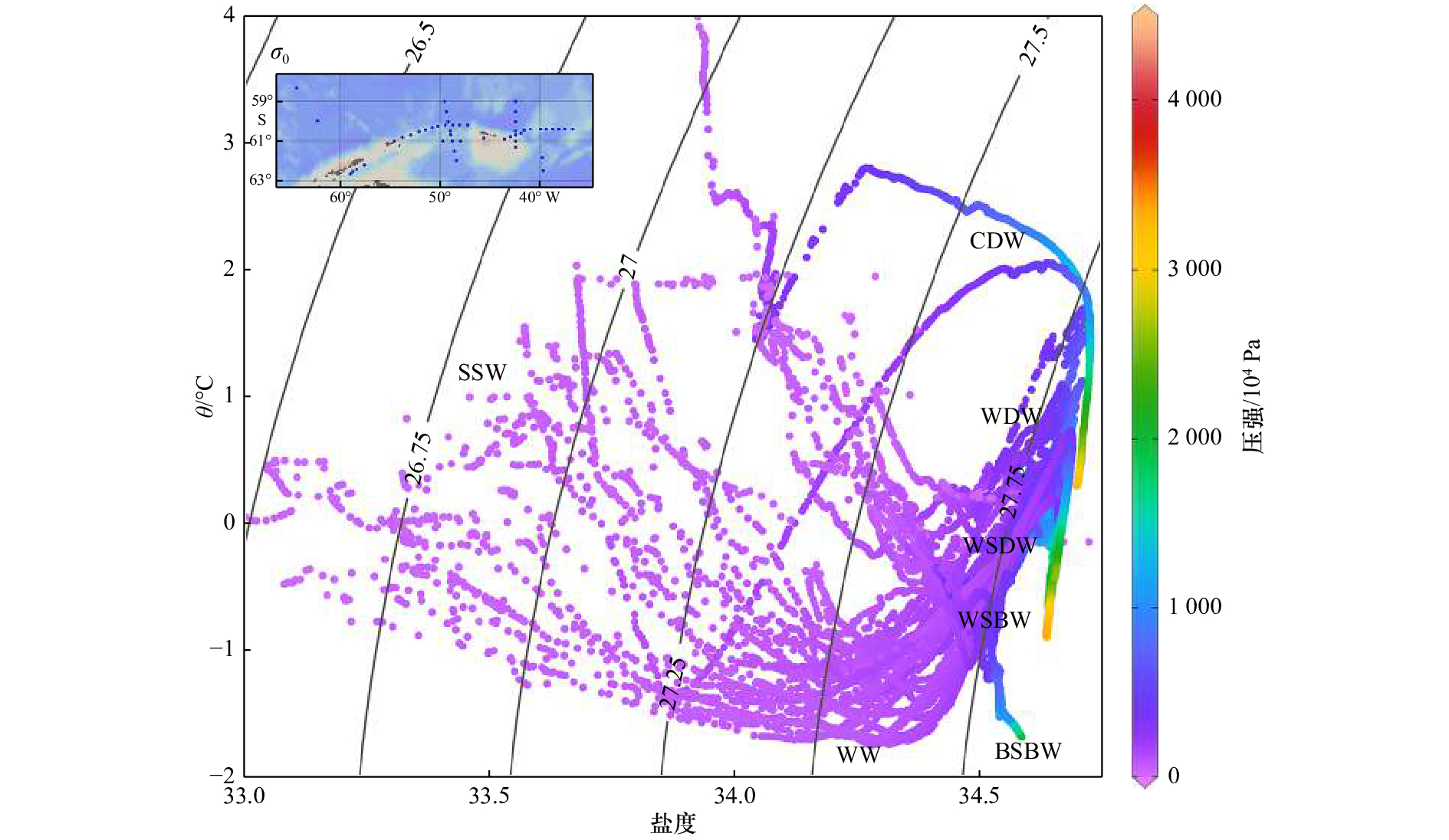
图 2 实测数据绘制的θ-S点聚图
等值线为中性密度,站点位置附在左上角,水团名称标记在水团核心附近
Fig. 2 θ-S scatter diagram of all hydrographic data in this cruise
The isoline is neutral density, and the site locations is attached to the upper left corner. The names of main water masses are also shown in the θ-S scatter diagram near the cores of the water masses

图 3 实测SR01-04、SR01-07、RY-A、RY-B、DZ-6、DZ-7站位(b)绘制的θ-S点聚图(a)
a图中线条颜色对应b图中站位标记的颜色,等值线为中性密度, 水团名称标记在水团核心附近
Fig. 3 θ-S scatter diagram (a) of SR01-04, SR01-07, RY-A, RY-B, DZ-6, DZ-7 sites (b) in this cruise
The colours of curves in a are responsible to the colours of sites dots in b, the isoline is neutral density. The names of main water masses are also shown in the θ-S scatter diagram near the cores of the water masses
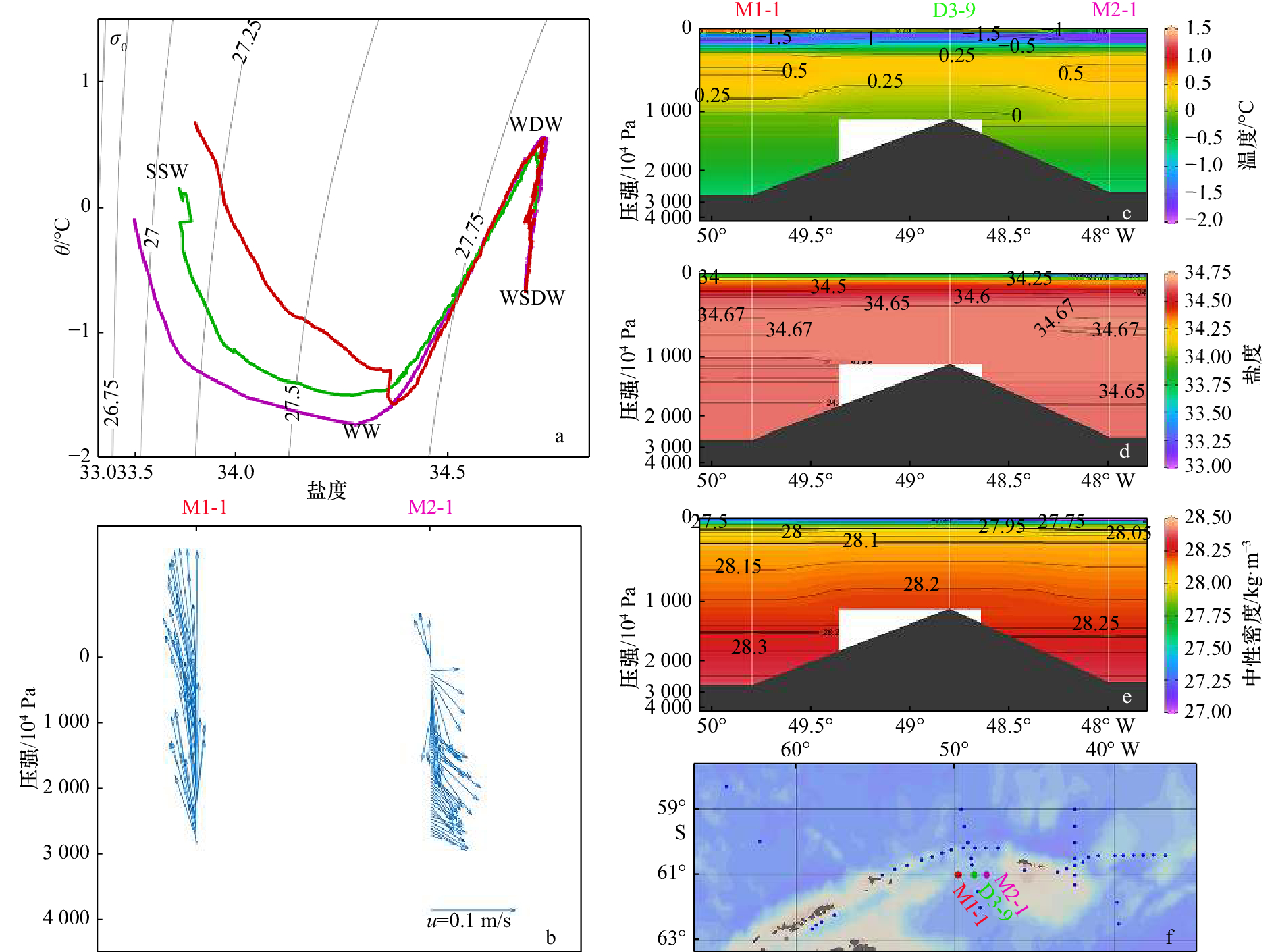
图 4 实测M断面绘制的θ-S点聚图(a),LADCP海流(b)、温度(c)、盐度(d)、中性密度(e)的垂向分布及站位位置(f)
a中线条颜色对应f中站位标记的颜色,等值线为中性密度,水团名称标记在水团核心附近
Fig. 4 θ-S scatter diagram of M profile(a), the vertical profiles of LADCP current (b), temperature (c), salinity (d), density (e), and the sites location (f)
The colours of curves in a are responsible to the colours of sites dots in f, the isoline is neutral density. The names of main water masses are also shown in the θ-S scatter diagram near the cores of the water masses

图 5 实测D3断面绘制的θ-S点聚图(a),LADCP海流(b)、温度(c)、盐度(d)、中性密度(e)的垂向分布及站位位置(f)
a中线条颜色对应f中站位标记的颜色,等值线为中性密度,水团名称标记在水团核心附近
Fig. 5 θ-S scatter diagram of D3 profile (a), the vertical profiles of LADCP current (b), temperature (c), salinity (d), density (e), and the sites location (f)
The colours of curves in a are responsible to the colours of sites dots in f, the isoline is neutral density. The names of main water masses are also shown in the θ-S scatter diagram near the cores of the water masses
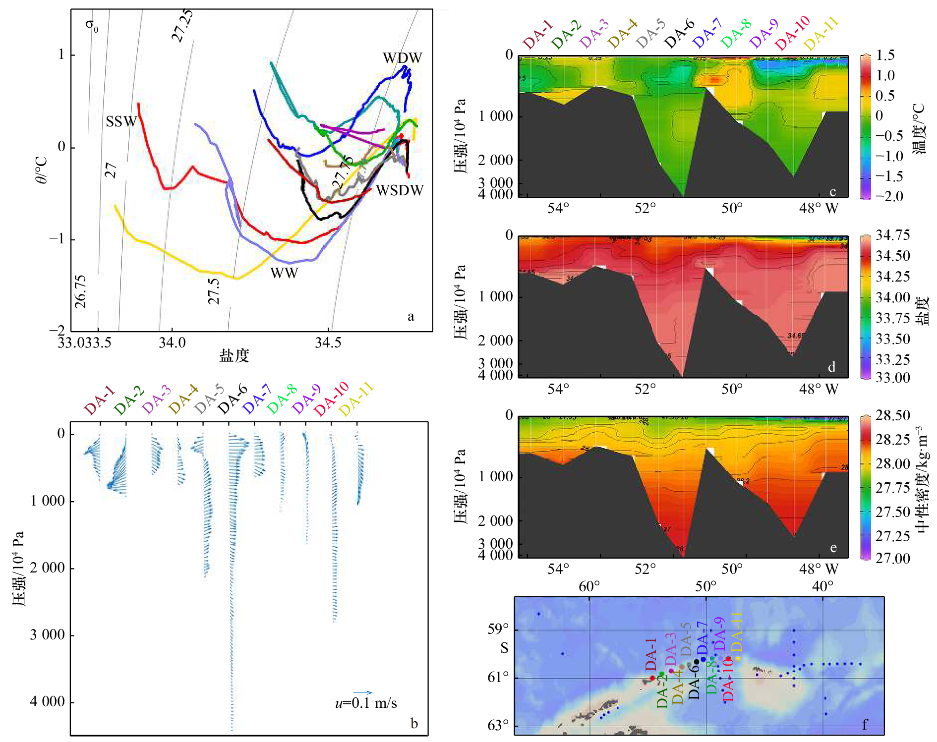
图 6 实测DA断面绘制的θ-S点聚图(a),LADCP海流(b)、温度(c)、盐度(d)、中性密度(e)的垂向分布及站位位置(f)
a中线条颜色对应f中站位标记的颜色,等值线为中性密度,水团名称标记在水团核心附近
Fig. 6 θ-S scatter diagram of DA profile (a), the vertical profiles of LADCP current (b), temperature (c), salinity (d), density (e), and the sites location (f)
The colours of curves in a are responsible to the colours of sites dots in f, the isoline is neutral density. The names of main water masses are also shown in the θ-S scatter diagram near the cores of the water masses

图 7 实测D5断面绘制的θ-S点聚图(a),LADCP海流(b)、温度(c)、盐度(d)、中性密度(e)的垂向分布及站位位置(f)
a中线条颜色对应f中站位标记的颜色,等值线为中性密度,水团名称标记在水团核心附近
Fig. 7 θ-S scatter diagram of D5 profile (a), the vertical profiles of LADCP current (b), temperature (c), salinity (d), density (e), and the sites location (f)
The colours of curves in a are responsible to the colours of sites dots in f, the isoline is neutral density. The names of main water masses are also shown in the θ-S scatter diagram near the cores of the water masses

图 8 实测DC断面绘制的θ-S点聚图(a),LADCP海流(b)、温度(c)、盐度(d)、中性密度(e)的垂向分布及站位位置(f)
a中线条颜色对应f中站位标记的颜色,等值线为中性密度,水团名称标记在水团核心附近
Fig. 8 θ-S scatter diagram of DC profile (a), the vertical profiles of LADCP current (b), temperature (c), salinity (d), density (e), and the sites location (f)
The colours of curves in a are responsible to the colours of sites dots in f, the isoline is neutral density. The names of main water masses are also shown in the θ-S scatter diagram near the cores of the water masses
表 1 前人对南极半岛周边海域主要水团性质的总结
Tab. 1 Summary of the main water masses properties in the region of Antarctic Peninsula
水团名称 子水团 温度/℃ 盐度 中性密度/kg·m−3 参考文献 AASW SSW −1.80~1.00 33.00~33.70 <27.40 [21] WW 约−1.50 33.80~34.00 27.20~27.40 [19] HSSW −1.88~−1.70 34.56~34.84 [22] CDW UCDW 温度极大值 34.61~34.68 27.95~28.27 [19] LCDW 1.30~1.60 盐度极大值 28.10~28.27 [7, 19] WDW 0~1.00 34.60~34.75 28.00~28.27 [17, 20] WSDW −0.70~0 34.62~34.68 28.27~28.40 [20-21] WSBW <−0.70 34.62~34.68 >28.40 [20-21] BSBW 中央海盆 约−1.60 约34.58 [10] 东海盆 约−1.00 约34.56 [10]  下载: 导出CSV
-
[1] Foster T D, Carmack E C. Temperature and salinity structure in the Weddell Sea[J]. Journal of Physical Oceanography, 1976, 6(1): 36−44. doi: 10.1175/1520-0485(1976)006<0036:TASSIT>2.0.CO;2 [2] Renner A H H, Heywood K J, Thorpe S E. Validation of three global ocean models in the Weddell Sea[J]. Ocean Modelling, 2009, 30(1): 1−15. doi: 10.1016/j.ocemod.2009.05.007 [3] Orsi A H, Nowlin Jr W D, Whitworth III T. On the circulation and stratification of the Weddell Gyre[J]. Deep-Sea Research Part I: Oceanographic Research Papers, 1993, 40(1): 169−203. doi: 10.1016/0967-0637(93)90060-G [4] Gordon A L, Visbeck M, Huber B. Export of Weddell Sea deep and bottom water[J]. Journal of Geophysical Research: Oceans, 2001, 106(C5): 9005−9017. doi: 10.1029/2000JC000281 [5] Von Gyldenfeldt A B, Fahrbach E, García M A, et al. Flow variability at the tip of the Antarctic Peninsula[J]. Deep-Sea Research Part II: Topical Studies in Oceanography, 2002, 49(21): 4743−4766. doi: 10.1016/S0967-0645(02)00157-1 [6] Franco B C, Mata M M, Piola A R, et al. Northwestern Weddell Sea deep outflow into the Scotia Sea during the austral summers of 2000 and 2001 estimated by inverse methods[J]. Deep-Sea Research Part I: Oceanographic Research Papers, 2007, 54(10): 1815−1840. doi: 10.1016/j.dsr.2007.06.003 [7] Palmer M, Gomis D, Flexas M D M, et al. Water mass pathways and transports over the South Scotia Ridge west of 50°W[J]. Deep-Sea Research Part I: Oceanographic Research Papers, 2012, 59: 8−24. doi: 10.1016/j.dsr.2011.10.005 [8] De Carvalho Ferreira M L, Kerr R. Source water distribution and quantification of North Atlantic deep water and Antarctic bottom water in the Atlantic Ocean[J]. Progress in Oceanography, 2017, 153: 66−83. doi: 10.1016/j.pocean.2017.04.003 [9] Talley L D. Closure of the global overturning circulation through the Indian, Pacific, and Southern Oceans: schematics and transports[J]. Oceanography, 2013, 26(1): 80−97. doi: 10.5670/oceanog [10] Purkey S G, Johnson G C. Warming of global abyssal and deep southern ocean waters between the 1990s and 2000s: contributions to global heat and sea level rise budgets[J]. Journal of Climate, 2010, 23(23): 6336−6351. doi: 10.1175/2010JCLI3682.1 [11] Rye C D, Naveira Garabato A C, Holland P R, et al. Rapid sea-level rise along the Antarctic margins in response to increased glacial discharge[J]. Nature Geoscience, 2014, 7(10): 732−735. doi: 10.1038/ngeo2230 [12] Gordon A L, Mensch M, Dong Zhaoqian, et al. Deep and bottom water of the Bransfield Strait eastern and central basins[J]. Journal of Geophysical Research Oceans, 2000, 105(C5): 11337−11346. doi: 10.1029/2000JC900030 [13] Carmack E C, Foster T D. On the flow of water out of the Weddell Sea[J]. Deep Sea Research and Oceanographic Abstracts, 1975, 22(11): 711−724. doi: 10.1016/0011-7471(75)90077-7 [14] Locarnini R A, Whitworth T, Nowlin W D. The importance of the Scotia Sea on the outflow of Weddell Sea deep water[J]. Journal of Marine Research, 1993, 51(1): 135−153. doi: 10.1357/0022240933223846 [15] Garabato A C N, Heywood K J, Stevens D P. Modification and pathways of Southern Ocean Deep Waters in the Scotia Sea[J]. Deep-Sea Research Part I: Oceanographic Research Papers, 2002, 49(4): 681−705. doi: 10.1016/S0967-0637(01)00071-1 [16] Marshall J, Speer K. Closure of the meridional overturning circulation through Southern Ocean upwelling[J]. Nature Geoscience, 2012, 5(3): 171−180. doi: 10.1038/ngeo1391 [17] Garabato A C N, McDonagh E L, Stevens D P, et al. On the export of Antarctic bottom water from the Weddell Sea[J]. Deep-Sea Research Part II: Topical Studies in Oceanography, 2002, 49(21): 4715−4742. doi: 10.1016/S0967-0645(02)00156-X [18] Meijers A J S, Meredith M P, Abrahamsen E P, et al. Wind-driven export of Weddell Sea slope water[J]. Journal of Geophysical Research: Oceans, 2016, 121(10): 7530−7546. doi: 10.1002/2016JC011757 [19] Fischer J, Visbeck M. Deep velocity profiling with self-contained ADCPs[J]. Journal of Atmospheric and Oceanic Technology, 1993, 10(5): 764−773. doi: 10.1175/1520-0426(1993)010<0764:DVPWSC>2.0.CO;2 [20] Visbeck M. Deep velocity profiling using lowered acoustic Doppler current profilers: bottom track and inverse solutions[J]. Journal of Atmospheric and Oceanic Technology, 2002, 19(5): 794−807. doi: 10.1175/1520-0426(2002)019<0794:DVPULA>2.0.CO;2 [21] Smith D A, Hofmann E E, Klinck J M, et al. Hydrography and circulation of the West Antarctic Peninsula Continental Shelf[J]. Deep-Sea Research Part I: Oceanographic Research Papers, 1999, 46(6): 925−949. doi: 10.1016/S0967-0637(98)00103-4 [22] Robertson R, Visbeck M, Gordon A L, et al. Long-term temperature trends in the deep waters of the Weddell Sea[J]. Deep-Sea Research Part II: Topical Studies in Oceanography, 2002, 49(21): 4791−4806. doi: 10.1016/S0967-0645(02)00159-5 [23] 史久新, 孙永明, 矫玉田, 等. 2011/2012年夏季南极半岛北端周边海域的水团与水交换[J]. 极地研究, 2016, 28(1): 67−79.Shi Jiuxin, Sun Yongming, Jiao Yutian, et al. Water masses and exchanges in the region around the northern tip of the Antarctic Peninsula observed in summer 2011/2012[J]. Chinese Journal of Polar Research, 2016, 28(1): 67−79. -

计量
- 文章访问数: 527
- HTML全文浏览量: 59
- PDF下载量: 208
- 被引次数: 0
