

Comparisons of composite radar backscattering model and sea surface radar backscatter from synthetic aperture radar, scatterometer and altimeter
-
摘要: 海洋微波散射模型相比于以经验统计建立的地球物理模式函数具有不受特定微波频率限制的优势。组合布拉格散射模型和几何光学模型形成了复合雷达后向散射模型。利用南海北部气象浮标2014年海面风速风向实测值作为散射模型输入,分别比较了复合雷达后向散射模型与RADARSAT-2卫星C波段SAR、HY-2A卫星Ku波段微波散射计的海面后向散射系数,偏差分别为(−0.22±1.88) dB (SAR)、(0.33±2.71) dB (散射计VV极化)和(−1.35±2.88) dB (散射计HH极化);以美国浮标数据中心(NDBC)浮标2011年10月1日至2014年9月30日共3年的海面风速、风向实测值作为散射模型输入,分别比较了复合雷达后向散射模型与Jason-2、HY-2A卫星Ku波段高度计海面后向散射系数,偏差分别为(1.01±1.15) dB和(1.12±1.29) dB。中等入射角和垂直入射下的卫星传感器后向散射系数观测值与复合雷达后向散射模型模拟值比较,具有不同的偏差,但具有相同的海面风速检验精度,均方根误差小于1.71 m/s。结果表明,复合雷达后向散射模型可模拟计算星载SAR、散射计和高度计观测条件下的海面雷达后向散射系数,且与CMOD5、NSCAT-2、高度计业务化海面风速反演的地球物理模式函数的计算结果具有一致性;复合雷达后向散射模型可用于微波遥感器的定标与检验、海面雷达后向散射的模拟。Abstract: Comparison with Geophysical Model Function (GMF) developed by methods of empirical statistics, ocean microwave scattering model works well at all microwave frequency. Composite radar backscattering model is comprised of Bragg scattering model and geometrical optics model. We calculated the normalized radar cross sections (NRCSs) from the composite scattering model by using the sea surface wind speeds and directions measured by buoys moored in the northern of South China Sea in the whole year of 2014, and then compared them with SAR on board RADARSAT-2 at C-band, microwave scatterometer on board HY-2A satellite (HSCAT) at Ku-band, respectively. The biases of comparison are (–0.22±1.88) dB ( for SAR), (0.33±2.71) dB (for HSCAT in VV polarization) and (–1.35±2.88) dB (for HSCAT in HH polarization), respectively. We also calculated the NRCSs from the model by using the sea surface wind speeds and directions measured by NDBC buoys in the time period from October 1, 2011 to September 30, 2014, and then compared them with radar altimeter on board Jason-2 and HY-2A both at Ku-band with the bias of (1.01±1.15) dB and (1.12±1.29) dB, respectively. Although the biases of NRCSs between space-borne sensors and composite scattering model in medium and normal incidence are different each other, the accuracies of their sea surface wind speed products are the same(i.e. the root mean square errors are all less than 1.71 m/s). The results show that we can simulate the sea surface radar NRCSs of satellite-borne SAR, microwave scatterometer, and altimeter by using the composite radar backscattering model, and the simulations are consistent with that of CMOD5, NSCAT-2 and the GMF of operational wind retrieval for altimeter. It also indicates that the composite radar backscattering model could be used in calibration and validation of microwave sensors and simulation of radar backscatter from sea surface.
-
Key words:
- radar backscattering model /
- synthetic aperture radar /
- scatterometer /
- altimeter
-
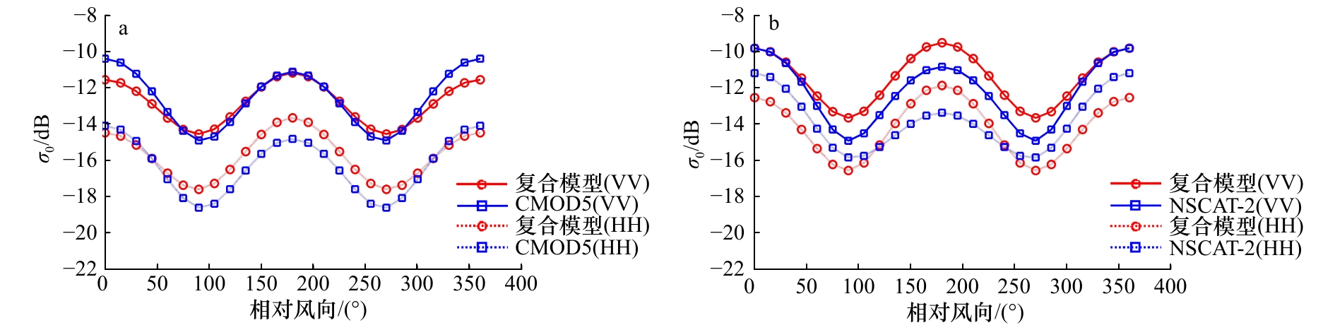
图 1 复合雷达后向散射模型与CMOD5、NSCAT-2地球物理模式函数的海面后向散射系数比较曲线
a. C波段(5.4 GHz);b. Ku波段(13.4 GHz)。海面风速为10 m/s,雷达波入射角为35°,CMOD5的HH极化后向散射系数由VV极化散射系数 乘以Thompson等[34]的极化比函数得到
Fig. 1 The comparisons of sea surface normalized radar cross sections (NRCSs) of composite radar backscattering model with GMFs of CMOD5 and NSCAT-2
a. C-band (5.4 GHz); b. Ku-Band (13.4 GHz). Sea surface wind speed at 10 m/s, incidence angle at 35°, NRCSs in HH polarization are calculated by the ones in VV polarization multiplied by polarization function of Thompson et al[34]
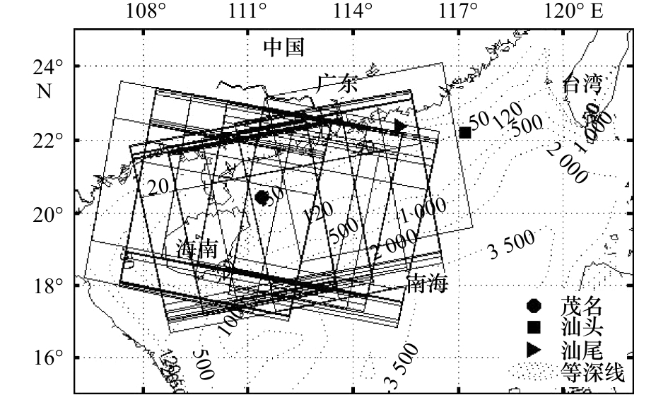
图 2 气象浮标位置、SAR图像覆盖范围及南海北部水深情况(水深单位:m)
Fig. 2 Locations of meteorological buoys,SAR images coverage and bathymetric charts of the northern of South China Sea (unit: m)
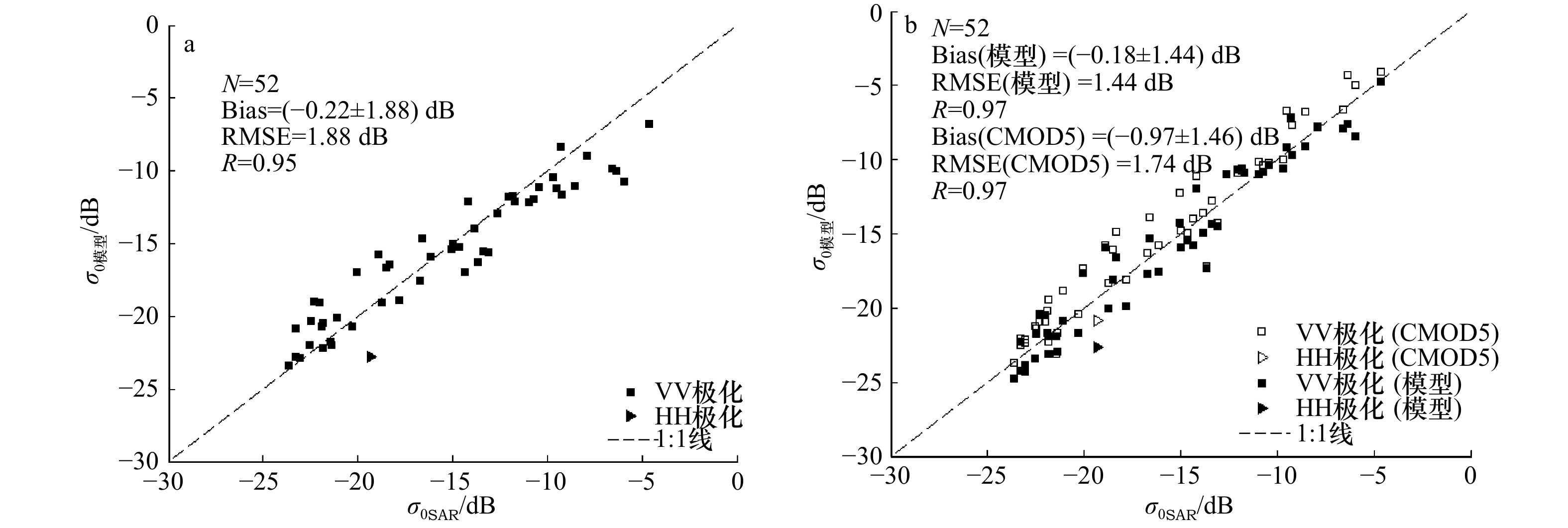
图 3 复合雷达后向散射模型、CMOD5地球物理模式函数和修正后的复合散射模型与SAR图像后向散射系数对比
a.复合雷达后向散射模型;b.CMOD5地球物理模式函数、修正后的复合散射模型。复合雷达后向散射模型的输入条件采用C波段、RADARSAT-2卫星SAR的雷达波入射角、方位角和浮标实测风速风向;每一个散点表示一景SAR图像与模型的对比数据;数据时间分布于 2013年4月4日至2015年4月18日
Fig. 3 Comparisons of NRCSs between composite radar backscattering model, CMOD5 GMF, revised composite scattering model and SAR image
a. Composite radar backscattering model; b. CMOD5 GMF, revised composite scattering model. The incidence angles and azimuths for composite radar backscattering model are the same as that of RARDASAT-2/SAR at C band, the wind speeds and directions are the same as buoy measurements; every scatter point represents one matching data of one SAR image; the SAR images are imaged in the time period from April 4, 2013 to April 18, 2015
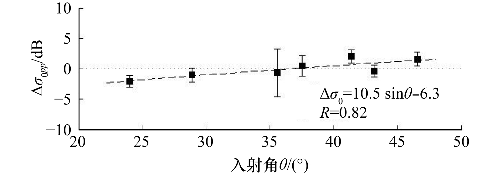
图 4 复合雷达后向散射模型与SAR后向散射系数的偏差
$\Delta {\sigma _0}$ 随雷达波入射角的变化实数据点和误差棒分别为不同入射角下$\Delta {\sigma _0}$的均值和标准差,直 线为$\Delta {\sigma _0}$随入射角变化的拟合直线
Fig. 4 The NRCSs bias between composite radar backscattering model and SAR versus radar wave incidences
The solid data points and error bars represent the mean value and standard deviation of $\Delta {\sigma _0}$ at different incidence, respectively; the straight line represents the fitting relationship between $\Delta {\sigma _0}$ and incidences

图 5 复合雷达后向散射模型、NSCAT-2地球物理模式函数计算的后向散射系数与HY-2A卫星微波散射计观测值的对比散点图
a.复合雷达后向散射模型,VV极化;b.复合雷达后向散射模型,HH极化;c.NSCAT-2,VV极化;d.NSCAT-2,HH极化。Ku波段,NSCAT-2的输 入条件采用HY-2A卫星散射计雷达波入射角、方位角和浮标实测风速风向;数据时间为2014年全年
Fig. 5 Comparisons of NRCSs between composite radar backscattering model,NSCAT-2 GMF and microwave scatterometer on board HY-2A satellite
a. Composite radar backscattering model,VV polarization; b. composite radar backscattering model, HH polarization;c. NSCAT-2, VV polarization; d. NSCAT-2, HH polarization. Ku-band, the incidence angles and azimuths for NSCAT-2 are the same as that of HY-2A scatterometer, the wind speeds and directions are the same as buoy measurements in the whole year of 2014

图 6 复合雷达后向散射模型、NSCAT-2地球物理模式函数计算的海面后向散射系数与HY-2A卫星微波散射计观测值的偏差的时间变化曲线
a. VV极化, b. HH极化。数据点代表每月的平均偏差、误差棒代 表偏差的标准差
Fig. 6 Time series of NRCSs bias between composite radar backscattering model, NSCAT GMF and HY-2A scatterometer
a. VV polarization, b. HH polarization. Data point represents monthly mean bias, error bar represents the standard deviation of the monthly biases

图 7 卫星雷达高度计Ku波段后向散射系数与复合后向散射模型、地球物理模式函数的比较
Fig. 7 Comparisons of NRCSs between composite backscattering model, GMF and satellite radar altimeter at Ku-band
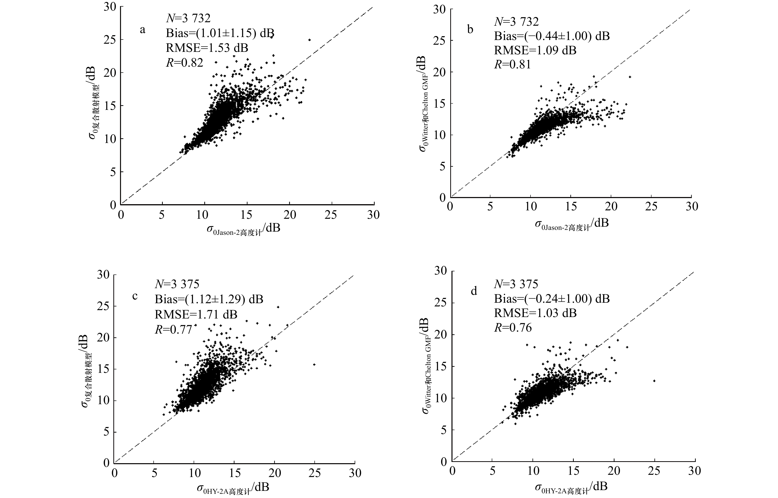
图 8 模型计算值与Jason-2、HY-2A卫星雷达高度计后散射系数观测值对比散点图
a, c. 复合雷达后向散射模型;b, d. Writter和Chelton[43]地球物理模式函数。Ku波段,模型输入采用NDBC浮标的实测风速风向;数据时间为 2011年10月1日至2014年9月30日
Fig. 8 Comparisons of NRCSs between the model and Jason-2, HY-2A altimeter
a, c. Composite radar backscattering model; b, d. Writter and Chelton[43] GMF. Ku-band, the wind speeds and directions are the same as NDBC buoy measurements in the time period from October 1, 2011 to September 30, 2014
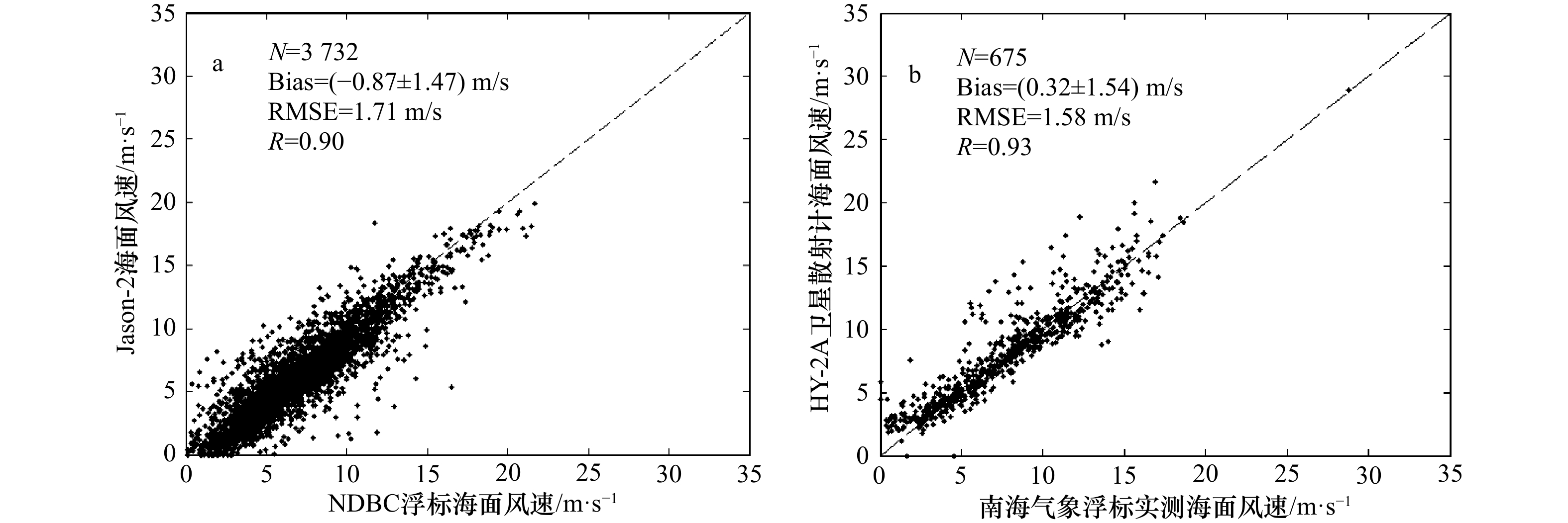
图 9 卫星遥感海面风速产品真实性检验结果
a为Jason-2卫星高度计,利用NDBC浮标检验,数据时间为2011年10月1日至2014年9月30日;b为HY-2A卫星微波散射计,利用南海北部 气象浮标检验,数据时间为2014年全年
Fig. 9 Validation results of sea surface wind speeds of satellite remote sensing products
a is Jason-2 validated against NDBC buoy measurements in the time period from October 1, 2011 to September 30, 2014; b is HY-2A scatterometer against meteorological buoy measurements located in the northern of South China Sea in the whole year of 2014
表 1 复合雷达后向散射模型与各卫星微波遥感器观测对比结果
Tab. 1 Comparison results of composite radar backscattering model with satellite-borne microwave sensors
卫星 遥感器
类型波段(频率) 数据量 复合模型 地球物理模式函数(GMF) 实测海面
风场来源偏差/dB RMSE/dB R 偏差/dB RMSE/dB R GMF名称 RADARSAT-2 合成孔
径雷达C波段
(5.405 GHz)52(VV极化51,
HH极化1)–0.22±1.88 1.88 0.95 0.97±1.46 1.74 0.97 CMOD5 南海北部
气象浮标–0.18±1.44* 1.44* 0.97* – – – HY–2A 散射计 Ku波段
(13.256 GHz)1 824(VV极化) 0.33±2.71 2.73 0.85 –0.13±2.61 2.61 0.86 NSCAT–2 南海北部
气象浮标2 215(HH极化) –1.35±2.88 3.18 0.83 –0.13±3.20 3.21 0.78 Jason–2 高度计 Ku波段
(13.6 GHz)3 732 1.01±1.15 1.53 0.82 –0.44±1.00 1.09 0.81 Writter和
Chelton[43],
T/P卫星高
度计风速反
演业务化算法NDBC浮标 HY–2A 高度计 Ku波段
(13.58 GHz)3 375 1.12±1.29 1.71 0.77 –0.24±1.00 1.03 0.76 注:*通过公式(14)校正后,与SAR的对比统计值。  下载: 导出CSV
-
[1] Quilfen Y, Chapron B, Elfouhaily T, et al. Observation of tropical cyclones by high-resolution scatterometry[J]. Journal of Geophysical Research, 1998, 103(C4): 7767−7786. doi: 10.1029/97JC01911 [2] Hersbach H, Stoffelen A, Haan S. An improved C-band scatterometer ocean geophysical model function: CMOD5[J]. Journal of Geophysical Research: Oceans, 2007, 112(C3): 223−237. [3] Wentz F J, Smith D K. A model function for the ocean-normalized radar cross section at 14 GHz derived from NSCAT observations[J]. Journal of Geophysical Research:Atmospheres, 1999, 104(C5): 11499−11514. doi: 10.1029/98JC02148 [4] 杨劲松, 黄韦艮, 周长宝, 等. 合成孔径雷达图像的近岸海面风场反演[J]. 遥感学报, 2001, 5(1): 13−16. doi: 10.11834/jrs.20010103Yang Jinsong, Huang Weigen, Zhou Changbao, et al. Coastal ocean surface wind retrieval from SAR imagery[J]. Journal of Remote Sensing, 2001, 5(1): 13−16. doi: 10.11834/jrs.20010103 [5] 杨劲松. 合成孔径雷达海面风场、海浪和内波遥感技术[D]. 青岛: 中国海洋大学, 2001.Yang Jinsong. Remote sensing technology of sea surface wind field, sea wave and internal wave by Synthetic Aperture Radar[D]. Qingdao: Ocean University of China, 2001. [6] Xu Qing, Lin Hui, Zheng Quanan, et al. Evaluation of ENVISAT ASAR data for sea surface wind retrieval in Hong Kong coastal waters of China[J]. Acta Oceanologica Sinica, 2008, 27(4): 57−62. [7] Valenzuela G R. Depolarization of EM waves by slightly rough surfaces[J]. IEEE Transactions on Antennas & Propagation, 1967, 15(4): 552−557. [8] Valenzuela G R. Scattering of electromagnetic waves from a tilted slightly rough surface[J]. Radio Science, 1968, 3(11): 1057. doi: 10.1002/rds.1968.3.issue-11 [9] Chan H L, Fung A K. A theory of sea scatter at large incident angles[J]. Journal of Geophysical Research, 1977, 82(24): 3439−3444. doi: 10.1029/JC082i024p03439 [10] Fung A K, Lee K. A semi-empirical sea-spectrum model for scattering coefficient estimation[J]. IEEE Journal of Oceanic Engineering, 1982, 7(4): 166−176. doi: 10.1109/JOE.1982.1145535 [11] Donelan M A, Pierson W J. Radar scattering and equilibrium ranges in wind-generated waves with application to scatterometry[J]. Journal of Geophysical Research, 1987, 92(C5): 4971−5029. doi: 10.1029/JC092iC05p04971 [12] 徐丰, 贾复. 适用于不同频率的微波海面散射计算方法[J]. 遥感技术与研究, 1996, 11(3): 26−30.Xu Feng, Jia Fu. A algorithm of sea surface radar scatter application to wide frequency band[J]. Remote Sensing Technology and Application, 1996, 11(3): 26−30. [13] 徐丰, 贾复, 马丽娟. 海面微波散射与风生波短波谱[J]. 遥感学报, 2000, 4(4): 251−255. doi: 10.11834/jrs.20000402Xu Feng, Jia Fu, Ma Lijuan. Microwave backscatter over the sea surface and spectrum of short wind-generated waves[J]. Journal of Remote Sensing, 2000, 4(4): 251−255. doi: 10.11834/jrs.20000402 [14] 郭立新, 王运华, 吴振森. 修正双尺度模型在非高斯海面散射中的应用[J]. 电波科学学报, 2007, 22(2): 212−218. doi: 10.3969/j.issn.1005-0388.2007.02.007Guo Lixin, Wang Yunhua, Wu Zhensen. Application of modified two-scale model for scattering from non-Gaussian sea surface[J]. Chinese Journal of Radio Science, 2007, 22(2): 212−218. doi: 10.3969/j.issn.1005-0388.2007.02.007 [15] Plant W J. A two-scale model of short wind-generated waves and scatterometry[J]. Journal of Geophysical Research, 1986, 91(C9): 10735−10749. doi: 10.1029/JC091iC09p10735 [16] Plant W J. A stochastic, multiscale model of microwave backscatter from the ocean[J]. Journal of Geophysical Research: Oceans, 2002, 107(C9): 3−1. [17] Hwang P A, Zhang Biao, Toporkov J V, et al. Comparison of composite Bragg theory and quad-polarization radar backscatter from RADARSAT-2: With applications to wave breaking and high wind retrieval[J]. Journal of Geophysical Research: Atmospheres, 2010, 115(C8): 246−255. [18] 喻亮, 丁晓松. 利用星载ERS-2 SAR进行长江口海面风场反演研究[J]. 信息与电子工程, 2005, 3(3): 172−175. doi: 10.3969/j.issn.1672-2892.2005.03.003Yu Liang, Ding Xiaosong. Ocean surface wind field retrieval of the Yangtze River outlet from spaceborne ERS-2 SAR Image[J]. Information and Electronic Engineering, 2005, 3(3): 172−175. doi: 10.3969/j.issn.1672-2892.2005.03.003 [19] Xu Qing, Lin Hui, Yin Xiaobin, et al. SAR measurement of ocean surface wind using a physics model[C]//Geoscience and Remote Sensing Symposium, 2008. IGARSS 2008. IEEE International, 2008: I–420–I–423. [20] Lin Mingsen, Ye Xiaomin, Yuan Xinzhe. The first quantitative joint observation of typhoon by Chinese GF-3 SAR and HY-2A microwave scatterometer[J]. Acta Oceanologica Sinica, 2017, 36(11): 1−3. doi: 10.1007/s13131-017-1133-9 [21] 魏士俨, 杨晟, 许德伟. 星载微波散射计海面风场与海洋环境噪声的相关特性分析[J]. 海洋学报, 2017, 39(5): 61−67. doi: 10.3969/j.issn.0253-4193.2017.05.006Wei Shiyan, Yang Sheng, Xu Dewei. Correlation analysis of satellite-borne microwave scatterometer wind and ocean ambient noise[J]. Haiyang Xuebao, 2017, 39(5): 61−67. doi: 10.3969/j.issn.0253-4193.2017.05.006 [22] 叶小敏, 林明森, 梁超, 等. 基于SAR图像雨团足印的海面风向提取方法[J]. 海洋学报, 2018, 40(4): 41−50. doi: 10.3969/j.issn.0253-4193.2018.04.004Ye Xiaomin, Lin Mingsen, Liang Chao, et al. Sea surface wind directions retrieval method based on footprints of rain cells on SAR images[J]. Haiyang Xuebao, 2018, 40(4): 41−50. doi: 10.3969/j.issn.0253-4193.2018.04.004 [23] Zheng Quanan, Clemente-Colón Pablo, Yan Xiaohai, et al. Satellite synthetic aperture radar detection of Delaware Bay plumes: Jet-like feature analysis[J]. Journal of Geophysical Research: Oceans, 2004, 109(3): 325−347. [24] Zheng Quanan, Lin Hui, Meng Junmin, et al. Sub-mesoscale ocean vortex trains in the Luzon Strait[J]. Journal of Geophysical Research: Atmospheres, 2008, 113(C4): 977−990. [25] Contreras R F, Plant W J. Surface effect of rain on microwave backscatter from the ocean: Measurements and modeling[J]. Journal of Geophysical Research: Atmospheres, 2006, 111(C8): 275−303. [26] Xu Feng, Li Xiaofeng, Wang Peng, et al. A backscattering model of rainfall over Rough Sea surface for synthetic aperture radar[J]. IEEE Transactions on Geoscience & Remote Sensing, 2015, 53(6): 3042−3054. [27] Zhang Guosheng, Li Xiaofeng, Perrie W, et al. Rain effects on the hurricane observations over the ocean by C-band synthetic aperture radar[J]. Journal of Geophysical Research: Oceans, 2016, 121(1): 14−26. doi: 10.1002/jgrc.v121.1 [28] Meissner T, Wentz F J. The complex dielectric constant of pure and sea water from microwave satellite observations[J]. IEEE Transactions on Geoscience and Remote Sensing, 2004, 42(9): 1836−1849. doi: 10.1109/TGRS.2004.831888 [29] Cox C S, Munk W H. Statistics of the sea surface derived from sun glitter[J]. Journal of Maritime Research, 1954, 13: 198−227. [30] Thomas B R, Kent E C, Swail V R. Methods to homogenize wind speeds from ships and buoys[J]. International Journal of Climatology, 2005, 25(7): 979−995. doi: 10.1002/(ISSN)1097-0088 [31] Elfouhaily T M, Chapron B, Katsaros K, et al. A unified directional spectrum for long and short wind-driven waves[J]. Journal of Geophysical Research: Oceans, 1997, 102(C7): 15781−15794. doi: 10.1029/97JC00467 [32] Stofflen A, Anderson D. Scatterometer data interpretation: Measurement space and validation of the transfer function CMOD4[J]. Journal of Geophysical Research, 1997, 102(6): 5767−5780. [33] Stoffelen A, Verspeek J A, Vogelzang J, et al. The CMOD7 geophysical model function for ASCAT and ERS wind retrievals[J]. IEEE Journal of Selected Topics in Applied Earth Observations & Remote Sensing, 2017, 10(5): 2123−2134. [34] Thompson D R, Elfouhaily T M, Chapron B. Polarization ratio for microwave backscattering from the ocean surface at low to moderate incidence angles[C]// Geoscience and Remote Sensing Symposium Proceedings, 1998. IEEE International, 1998: 1671–1673. [35] 赵中阔, 刘春霞. 华南近海两浮标点的波浪特征分析[J]. 广东气象, 2013, 35(6): 17−22. doi: 10.3969/j.issn.1007-6190.2013.06.004Zhao Zhongkuo, Liu Chunxia. Wave characteristics of two buoy points in South China offshore[J]. Guangdong Meteorology, 2013, 35(6): 17−22. doi: 10.3969/j.issn.1007-6190.2013.06.004 [36] Morena L C, James K V, Beck J. An introduction to the RADARSAT-2 mission[J]. Canadian Journal of Remote Sensing, 2004, 30(3): 221−234. doi: 10.5589/m04-004 [37] Jiang Xingwei, Lin Mingsen, Liu Jianqiang, et al. The HY-2 satellite and its preliminary assessment[J]. International Journal of Digital Earth, 2012, 5(3): 266−281. doi: 10.1080/17538947.2012.658685 [38] 蒋兴伟, 林明森, 宋清涛. 海洋二号卫星主被动微波遥感探测技术研究[J]. 中国工程科学, 2013, 15(7): 4−11. doi: 10.3969/j.issn.1009-1742.2013.07.001Jiang Xingwei, Lin Mingsen, Song Qingtao. Active and passive microwave remote sensing technology of the HY-2A ocean satellite mission[J]. Engineering Sciences, 2013, 15(7): 4−11. doi: 10.3969/j.issn.1009-1742.2013.07.001 [39] 叶小敏, 林明森, 宋庆君. 基于现场观测数据的卫星雷达高度计海面风速和有效波高真实性检验方法研究[J]. 遥感技术与应用, 2014, 29(1): 26−32.Ye Xiaomin, Lin Mingsen, Song Qingjun. Research on validation methods of satellite radar altimeter retrieved sea surface wind speed and significant wave height using in-situ data[J]. Remote Sensing Technology and application, 2014, 29(1): 26−32. [40] Luscombe A. RADARSAT-2 product format definition. Richmond[Z]. Canada: MacDonald Dettwiler RN-RP-51-2713, 2008. [41] Ye Xiaomin, Lin Mingsen, Xu Ying. Validation of Chinese HY-2 satellite radar altimeter significant wave height[J]. Acta Oceanologica Sinica, 2015, 34(5): 60−67. doi: 10.1007/s13131-015-0667-y [42] Chelton D B, Mccabe P J. A review of satellite altimeter measurement of sea surface wind speed: With a proposed new algorithm[J]. Journal of Geophysical Research, 1985, 90(C3): 4707−4720. doi: 10.1029/JC090iC03p04707 [43] Witter D L, Chelton D B. A Geosat altimeter wind speed algorithm and a method for altimeter wind speed algorithm development[J]. Journal of Geophysical Research, 1991, 96(C5): 8853−8860. doi: 10.1029/91JC00414 [44] Blanc F, Borra M, Boudou P, et al. AVISO User Handbook—Merged TOPEX/Poseidon Products (GDR-Ms)[Z]. AVI-NT-02-101-CN, Edition 3.0, 1996. [45] Picot N, Desai S. AVISO and PODAAC User Handbook—IGDR and GDR Jason-1 Product[Z]. SMM-MU-M5-OP-13184-CN, Edition 4.1, 2008. [46] Dumont J P, Rosmorduc V, Carrere L, et al. OSTM/Jason-2 Products Handbook[Z]. SALP-MU-M-OP-15815-CN, Edition 1 rev 9, 2015. [47] Young I R. An estimate of the Geosat altimeter wind speed algorithm at high wind speeds[J]. Journal of Geophysical Research, 1993, 98(C11): 20275−20285. doi: 10.1029/93JC02117 [48] 穆博, 林明森, 彭海龙, 等. HY-2卫星微波散射计反演风矢量产品真实性检验方法研究[J]. 中国工程科学, 2014, 16(6): 39−45. doi: 10.3969/j.issn.1009-1742.2014.06.006Mu Bo, Lin Mingsen, Peng Hailong, et al. Validation of wind vectors retrieved by the HY-2 microwave scatterometer using NCEP model data[J]. Engineering Sciences, 2014, 16(6): 39−45. doi: 10.3969/j.issn.1009-1742.2014.06.006 -


计量
- 文章访问数: 729
- HTML全文浏览量: 106
- PDF下载量: 349
- 被引次数: 0
