

A method for solving along-track vertical deflection based on SWOT wide-swath simulated data
-
摘要: 2022年12月16日成功发射的SWOT是新一代宽刈幅测高卫星,预期可以提供全球海域及内陆水面的二维条带高度信息,有望解决传统一维观测值解算垂线偏差方向分量精度不一的问题。本文利用SWOT模拟数据联立多个方向求解沿轨垂线偏差,并根据模拟数据特点提出两种提升解算精度方案:一是选取联立观测值时适当增大距离,二是根据SWOT条带数据质量分别赋权。与EGM2008模型检核表明,SWOT模拟数据求得的垂线偏差南北向检核标准差为0.416 8角秒,东西向模型检核标准差为0.472 9角秒,解算质量优于其他方案,证明了改进方案的可行性,并利用“天宫二”号宽刈幅数据进行了方法验证,表明可应用于SWOT真实数据求解垂线偏差。Abstract: The SWOT was successfully launched on December 16, 2022, which is a new generation of wide-swath altimetry satellite. The SWOT is expected to provide two-dimensional strip hight informations of global sea area and inland water surface. It is expected to solve the problem of traditional one-dimensional observations, which is inconsistent accuracy in solving the directional component of the vertical deflection. In this paper, we adopted SWOT simulated data to solve along-track vertical deflection by jointing multi-directions, and proposed two upgrading schemes according to the characteristics of the simulated data: one is to increase the distance of joint observations appropriately, and the other is to assign weights according to the quality of SWOT strip data separately. The vertical deflection of the SWOT simulated data solved is checked with EGM2008 model, the standard deviation of the north component and east component are 0.416 8, 0.472 9 arcsec respectively. The solution quality is better than other schemes, it proves the feasibility of improved schemes. The method is also validated using Tiangong II wide-swath data. So it can be applied to SWOT real data to solve the vertical deflection.
-
Key words:
- SWOT /
- wide-swath interferometer /
- simulated data /
- vertical deflection
-
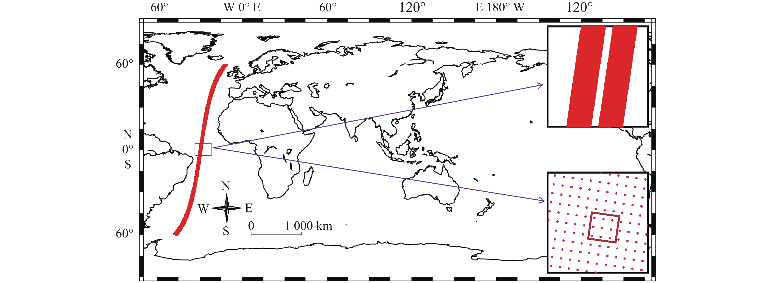
图 1 SWOT模拟数据升轨pass7的中低纬度区域
Fig. 1 The middle and low latitudes of the ascending orbit pass7 of SWOT simulated data
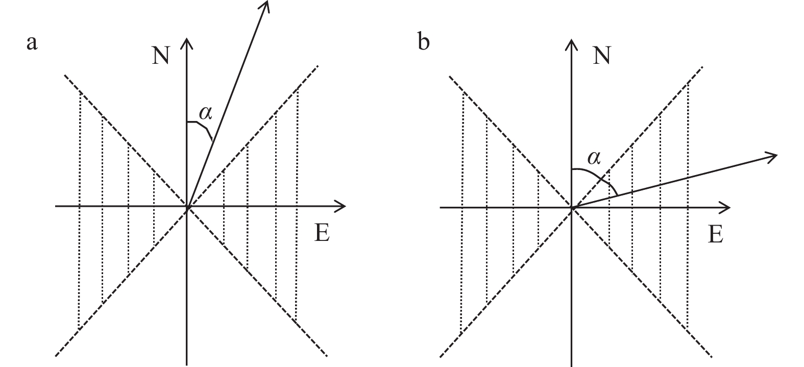
图 3 各方向的南北分量和东西分量受方位角影响
a. 东西分量的偏差大于南北分量;b. 南北分量的偏差大于东西分量
Fig. 3 The north component and east component in each direction are influenced by the azimuth angle
a. The deviation of the east component is larger than the north component; b. the deviation of the north component is larger than the east component
表 1 8个方向分别求解垂线偏差与EGM2008垂线偏差差值分析结果(单位:角秒)
Tab. 1 Analysis results of the difference between vertical deflection solved in eight directions and EGM2008 vertical deflection (unit: arcsec)
方向选择 垂线偏差分量 最大值 最小值 平均值 标准差 沿轨1 南北分量 11.359 4 −11.933 7 −0.068 1 1.933 0 东西分量 20.136 0 −20.087 6 0.624 3 3.123 4 跨轨1 南北分量 26.608 9 −39.520 3 0.579 3 3.763 3 东西分量 11.707 2 −15.985 4 0.095 8 1.988 9 对角线1 南北分量 17.611 9 −32.169 4 −0.008 5 3.368 8 东西分量 18.469 7 −12.601 1 0.036 8 2.222 8 对角线2 南北分量 15.843 1 −17.239 4 0.519 9 2.059 5 东西分量 17.244 3 −29.155 8 0.683 9 2.878 0 沿轨2 南北分量 11.558 7 −11.664 5 −0.068 3 1.931 3 东西分量 20.652 3 −19.987 9 0.624 3 3.124 7 跨轨2 南北分量 26.502 9 −40.789 0 0.579 3 3.766 3 东西分量 11.968 8 −15.938 9 0.093 5 1.979 5 对角线3 南北分量 17.438 0 −32.017 8 −0.009 6 3.360 7 东西分量 19.015 4 −13.410 8 0.034 9 2.230 9 对角线4 南北分量 14.903 0 −17.858 3 0.521 0 2.057 7 东西分量 19.487 3 −29.288 9 0.682 4 2.881 7  下载: 导出CSV
表 2 联合不同方向求解垂线偏差与EGM2008垂线偏差差值分析结果(单位:角秒)
Tab. 2 Analysis results of the difference between the joint different directions of solved vertical deflection and EGM2008 vertical deflection (unit: arcsec)
方向选择及
权重分配垂线偏差分量 最大值 最小值 平均值 标准差 两方向等权法 南北分量 10.197 2 −9.930 3 −0.035 5 1.607 3 东西分量 11.814 0 −13.281 2 0.028 9 1.935 2 两对角线方向
等权法南北分量 8.162 7 −7.043 8 −0.035 5 1.024 7 东西分量 11.707 2 −9.873 3 0.028 8 1.574 2 四方向等权法 南北分量 6.066 7 −5.552 7 −0.035 5 0.937 5 东西分量 11.441 7 −10.277 0 0.028 9 1.590 1 四方向距离反比法 南北分量 6.493 6 −6.037 7 −0.035 5 1.018 8 东西分量 11.505 6 −10.792 6 0.028 8 1.629 1 四方向距离正比法 南北分量 5.783 4 −5.341 6 −0.035 5 0.880 4 东西分量 11.377 8 −9.761 4 0.028 9 1.561 1 八方向距离正比法 南北分量 3.932 0 −3.855 0 −0.035 5 0.669 1 东西分量 4.495 3 −4.030 1 0.027 3 0.694 4
下载: 导出CSV
表 3 不同方法求解垂线偏差与EGM2008垂线偏差差值分析结果(单位:角秒)
Tab. 3 Analysis results of the difference between vertical deflection solved by different methods and EGM2008 vertical deflection (unit: arcsec)
方向选择 垂线偏差误差 最大值 最小值 平均值 标准差 八方向
(增大两倍距离)南北分量 2.502 6 −2.500 0 −0.036 0 0.446 6 东西分量 2.556 2 −2.563 7 0.029 1 0.499 6 十六方向
(增大两倍距离)南北分量 2.149 7 −2.419 6 −0.036 0 0.417 7 东西分量 2.507 4 −2.688 5 0.029 2 0.474 0 五方向
(左侧边缘条带)南北分量 4.956 2 −5.123 8 0.039 6 1.386 1 东西分量 9.281 3 −8.831 0 −0.022 1 2.627 2
下载: 导出CSV
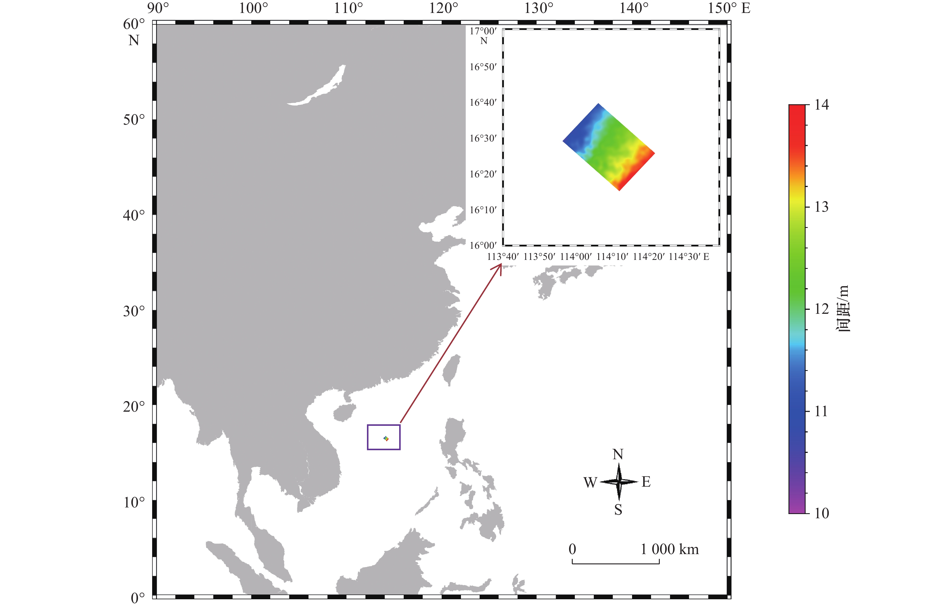
表 4 SWOT升轨pass7各条带与DTU18MSS差值分析(单位:m)
Tab. 4 Analysis of the difference between each strip of SWOT ascending track pass7 and DTU18MSS (unit: m)
条带号 平均差值 标准差 条带号 平均差值 标准差 条带号 平均差值 标准差 条带号 平均差值 标准差 1 0 0 19 −0.486 2 0.459 4 37 0 0 55 −0.498 2 0.467 7 2 0 0 20 −0.486 4 0.458 1 38 0 0 56 −0.499 5 0.469 0 3 0 0 21 −0.486 4 0.456 5 39 0 0 57 −0.499 8 0.470 2 4 0 0 22 −0.486 5 0.455 0 40 0 0 58 −0.501 0 0.471 3 5 0 0 23 −0.486 7 0.453 7 41 −0.492 8 0.453 5 59 −0.501 0 0.472 1 6 −0.484 6 0.477 9 24 −0.486 7 0.452 5 42 −0.492 4 0.454 2 60 −0.501 4 0.473 0 7 −0.484 5 0.476 3 25 −0.486 8 0.451 1 43 −0.493 6 0.455 2 61 −0.501 6 0.473 9 8 −0.485 2 0.475 0 26 −0.486 8 0.450 0 44 −0.493 6 0.456 1 62 −0.502 3 0.474 9 9 −0.484 7 0.473 5 27 −0.487 0 0.448 5 45 −0.494 0 0.457 0 63 −0.502 4 0.475 9 10 −0.485 6 0.472 1 28 −0.486 8 0.447 2 46 −0.494 4 0.458 1 64 −0.503 7 0.477 1 11 −0.485 4 0.470 4 29 −0.487 0 0.445 9 47 −0.495 0 0.459 3 65 −0.502 4 0.478 1 12 −0.485 6 0.468 9 30 −0.487 3 0.444 8 48 −0.495 6 0.460 5 66 −0.503 9 0.479 3 13 −0.485 2 0.467 3 31 −0.487 2 0.443 8 49 −0.496 0 0.461 5 67 0 0 14 −0.485 4 0.466 0 32 0 0 50 −0.496 1 0.462 5 68 0 0 15 −0.485 7 0.464 7 33 0 0 51 −0.496 5 0.463 7 69 0 0 16 −0.485 5 0.463 4 34 0 0 52 −0.497 5 0.464 9 70 0 0 17 −0.485 4 0.461 9 35 0 0 53 −0.498 2 0.465 9 71 0 0 18 −0.485 6 0.460 6 36 0 0 54 −0.499 1 0.466 9
下载: 导出CSV
表 5 联合多方向并增大两倍距离和降权求解垂线偏差与EGM2008垂线偏差差值分析结果(单位:角秒)
Tab. 5 Analysis results of the difference between the joint multi-direction and twice the distance and reducing the weight solved vertical deflection and EGM2008 vertical deflection (unit: arcsec)
方向选择 垂线偏差
误差最大值 最小值 平均值 标准差 八方向(增大两倍距离+
所有方向调整权重)南北分量 2.442 3 −2.462 6 −0.036 1 0.446 1 东西分量 2.471 4 −2.578 1 0.029 4 0.499 5 八方向(增大两倍距离+
非对角线方向调整权重)南北分量 2.635 5 −2.685 9 −0.036 1 0.445 4 东西分量 2.587 4 −2.566 3 0.029 2 0.497 5 十六方向(增大两倍距离+
非对角线方向调整权重)南北分量 2.338 1 −2.376 5 −0.036 0 0.416 8 东西分量 2.565 6 −2.671 3 0.029 3 0.472 9
下载: 导出CSV
表 6 “天宫二”号数据求解垂线偏差与EGM2008差值分析(单位:角秒)
Tab. 6 Analysis results of the difference between vertical deflection solved with Tiangong-2 data and EGM2008 vertical deflection (unit: arcsec)
方向选择 垂线偏差分量 最大值 最小值 平均值 标准差 八方向 南北分量 38.172 0 −34.689 3 0.998 8 10.893 3 东西分量 38.082 6 −55.773 0 0.837 4 10.915 0 八方向 南北分量 0.613 3 −0.951 0 −0.084 3 0.386 6 (增大联立观
测值距离)东西分量
2.218 2
0.259 8
1.085 8
0.441 1
下载: 导出CSV
-
[1] 陈欣, 翟国君, 暴景阳, 等. 垂线偏差反演重力异常中央区效应计算模型[J]. 海洋测绘, 2016, 36(2): 6−9. doi: 10.3969/j.issn.1671-3044.2016.02.002Chen Xin, Zhai Guojun, Bao Jingyang, et al. Gravity anomaly inversion using deflection of the vertical based on singular transformation in rectangle innermost areas[J]. Hydrographic Surveying and Charting, 2016, 36(2): 6−9. doi: 10.3969/j.issn.1671-3044.2016.02.002 [2] 彭富清, 陈双军, 金群峰. 卫星测高误差对海洋重力场反演的影响[J]. 测绘学报, 2014, 43(4): 337−340. doi: 10.13485/j.cnki.11-2089.2014.0050Peng Fuqing, Chen Shuangjun, Jin Qunfeng. Influence of altimetry errors on marine geopotential recovery[J]. Acta Geodaetica et Cartographica Sinica, 2014, 43(4): 337−340. doi: 10.13485/j.cnki.11-2089.2014.0050 [3] 张胜军, 李建成, 褚永海, 等. 基于Cryosat和Jason1 GM数据的垂线偏差计算与分析[J]. 武汉大学学报:信息科学版, 2015, 40(8): 1012−1017.Zhang Shengjun, Li Jiancheng, Chu Yonghai, et al. Calculation and analysis of the deflection of vertical derived from Cryosat and Jason1 GM data[J]. Geomatics and Information Science of Wuhan University, 2015, 40(8): 1012−1017. [4] 郭金运, 金鑫, 边少锋, 等. 垂线偏差测量的固体潮和海潮改正[J]. 测绘学报, 2022, 51(7): 1215−1224. doi: 10.11947/j.issn.1001-1595.2022.7.chxb202207013Guo Jinyun, Jin Xin, Bian Shaofeng, et al. Corrections of solid earth tide and ocean tide for measurement of deflection of the vertical[J]. Acta Geodaetica et Cartographica Sinica, 2022, 51(7): 1215−1224. doi: 10.11947/j.issn.1001-1595.2022.7.chxb202207013 [5] 翟振和, 孙中苗, 肖云, 等. 自主海洋测高卫星串飞模式的设计与重力场反演精度分析[J]. 武汉大学学报:信息科学版, 2018, 43(7): 1030−1035, 1128. doi: 10.13203/j.whugis20160234Zhai Zhenhe, Sun Zhongmiao, Xiao Yun, et al. Two-satellites tandem mode design and accuracy analysis of gravity field inversion for independent marine altimetry satellite[J]. Geomatics and Information Science of Wuhan University, 2018, 43(7): 1030−1035, 1128. doi: 10.13203/j.whugis20160234 [6] 王虎彪, 王勇, 柴华, 等. 中国西太平洋海域1′ × 1′垂线偏差模型及精度评估[J]. 测绘学报, 2017, 46(9): 1073−1079.Wang Hubiao, Wang Yong, Chai Hua, et al. 1′ × 1′ vertical deflection and its precision evaluation on China West Pacific Ocean region[J]. Acta Geodaetica et Cartographica Sinica, 2017, 46(9): 1073−1079. [7] Andersen O B, Knudsen P, Berry P A M. The DNSC08GRA global marine gravity field from double retracked satellite altimetry[J]. Journal of Geodesy, 2010, 84(3): 191−199. doi: 10.1007/s00190-009-0355-9 [8] Fu L L, Ubelmann C. On the transition from profile altimeter to swath altimeter for observing global ocean surface topography[J]. Journal of Atmospheric and Oceanic Technology, 2014, 31(2): 560−568. doi: 10.1175/JTECH-D-13-00109.1 [9] Sandwell D T, Harper H, Tozer B, et al. Gravity field recovery from geodetic altimeter missions[J]. Advances in Space Research, 2021, 68(2): 1059−1072. doi: 10.1016/j.asr.2019.09.011 [10] 车德福, 李航, 张胜军, 等. 同步激光测高数据的垂线偏差解算与分析[J]. 测绘科学, 2021, 46(11): 24−31. doi: 10.16251/j.cnki.1009-2307.2021.11.005Che Defu, Li Hang, Zhang Shengjun, et al. Calculation and analysis of vertical deflection of simultaneous laser altimetry data[J]. Science of Surveying and Mapping, 2021, 46(11): 24−31. doi: 10.16251/j.cnki.1009-2307.2021.11.005 [11] 徐永生, 高乐, 张云华. 美国新一代测高卫星SWOT——评述我国宽刈幅干涉卫星的发展借鉴[J]. 遥感技术与应用, 2017, 32(1): 84−94.Xu Yongsheng, Gao Le, Zhang Yunhua. New generation altimetry satellite SWOT and its reference to China’s swath altimetrysatellite[J]. Remote Sensing Technology and Application, 2017, 32(1): 84−94. [12] Morrow R, Fu L L, Rodriguez E. SWOT: a high-resolution wide-swath altimetry mission for oceanography and hydrology[C]//Proceedings of the EGU General Assembly 2013. Vienna, Austria: EGU, 2013: EGU2013-7382. [13] Morrow R, Fu L L, Ardhuin F, et al. Global observations of fine-scale ocean surface topography with the surface water and ocean topography (SWOT) mission[J]. Frontiers in Marine Science, 2019, 6: 232. doi: 10.3389/fmars.2019.00232 [14] Yu Daocheng, Hwang C, Andersen O B, et al. Gravity recovery from SWOT altimetry using geoid height and geoid gradient[J]. Remote Sensing of Environment, 2021, 265: 112650. doi: 10.1016/j.rse.2021.112650 [15] Chaudhary A, Agarwal N, Sharma R, et al. Nadir altimetry Vis-à-Vis swath altimetry: a study in the context of SWOT mission for the Bay of Bengal[J]. Remote Sensing of Environment, 2021, 252: 112120. doi: 10.1016/j.rse.2020.112120 [16] Verron J, Bonnefond P, Aouf L, et al. The benefits of the ka-band as evidenced from the SARAL/AltiKa altimetric mission: scientific applications[J]. Remote Sensing, 2018, 10(2): 163. doi: 10.3390/rs10020163 [17] Guerreiro K, Fleury S, Zakharova E, et al. Potential for estimation of snow depth on Arctic sea ice from CryoSat-2 and SARAL/AltiKa missions[J]. Remote Sensing of Environment, 2016, 186: 339−349. doi: 10.1016/j.rse.2016.07.013 [18] D’Addezio J M, Smith S, Jacobs G A, et al. Quantifying wavelengths constrained by simulated SWOT observations in a submesoscale resolving ocean analysis/forecasting system[J]. Ocean Modelling, 2019, 135: 40−55. doi: 10.1016/j.ocemod.2019.02.001 [19] Elmer N J, Hain C, Hossain F, et al. Generating proxy SWOT water surface elevations using WRF-hydro and the CNES SWOT hydrology simulator[J]. Water Resources Research, 2020, 56(8): e2020WR027464. doi: 10.1029/2020WR027464 [20] de Moraes Frasson R P, Wei Rui, Durand M, et al. Automated river reach definition strategies: applications for the surface water and ocean topography mission[J]. Water Resources Research, 2017, 53(10): 8164−8186. doi: 10.1002/2017WR020887 [21] Huang Qi, Long Di, Du Mingda, et al. Daily continuous river discharge estimation for ungauged basins using a hydrologic model calibrated by satellite altimetry: implications for the SWOT mission[J]. Water Resources Research, 2020, 56(7): e2020WR027309. doi: 10.1029/2020WR027309 [22] Wang Jinbo, Fu L L, Qiu Bo, et al. An observing system simulation experiment for the calibration and validation of the surface water ocean topography sea surface height measurement using in situ platforms[J]. Journal of Atmospheric and Oceanic Technology, 2018, 35(2): 281−297. doi: 10.1175/JTECH-D-17-0076.1 [23] Fu L L, Alsdorf D, Rodriguez E, et al. The SWOT (surface water and ocean topography) mission: spaceborne radar interferometry for oceanographic and hydrological applications[C]//Proceedings of the OCEANOBS’09 Conference. [S. l.: s.n.], 2009. [24] Wan Xiaoyun, Jin Shuanggen, Liu Bo, et al. Effects of interferometric radar altimeter errors on marine gravity field inversion[J]. Sensors, 2020, 20(9): 2465. doi: 10.3390/s20092465 [25] Jin Taoyong, Zhou Mao, Zhang Huan, et al. Analysis of vertical deflections determined from one cycle of simulated SWOT wide-swath altimeter data[J]. Journal of Geodesy, 2022, 96(4): 30. doi: 10.1007/s00190-022-01619-8 [26] Peral E, Esteban-Fernandez D. Swot mission performance and error budget[C]//Proceedings of 2018 IEEE International Geoscience and Remote Sensing Symposium. Valencia, Spain: IEEE, 2018: 8625−8628. [27] Gaultier L, Ubelmann C, Fu L L. The challenge of using future SWOT data for oceanic field reconstruction[J]. Journal of Atmospheric and Oceanic Technology, 2016, 33(1): 119−126. doi: 10.1175/JTECH-D-15-0160.1 [28] Pavlis N K, Holmes S A, Kenyon S C, et al. The development and evaluation of the Earth Gravitational Model 2008 (EGM2008)[J]. Journal of Geophysical Research: Solid Earth, 2012, 117(B4): B04406. [29] Miao Xiangying, Wang Jing, Mao Peng, et al. Cross-track error correction and evaluation of the tiangong-2 interferometric imaging radar altimeter[J]. IEEE Geoscience and Remote Sensing Letters, 2022, 19: 1505505. -


计量
- 文章访问数: 583
- HTML全文浏览量: 321
- PDF下载量: 50
- 被引次数: 0
