

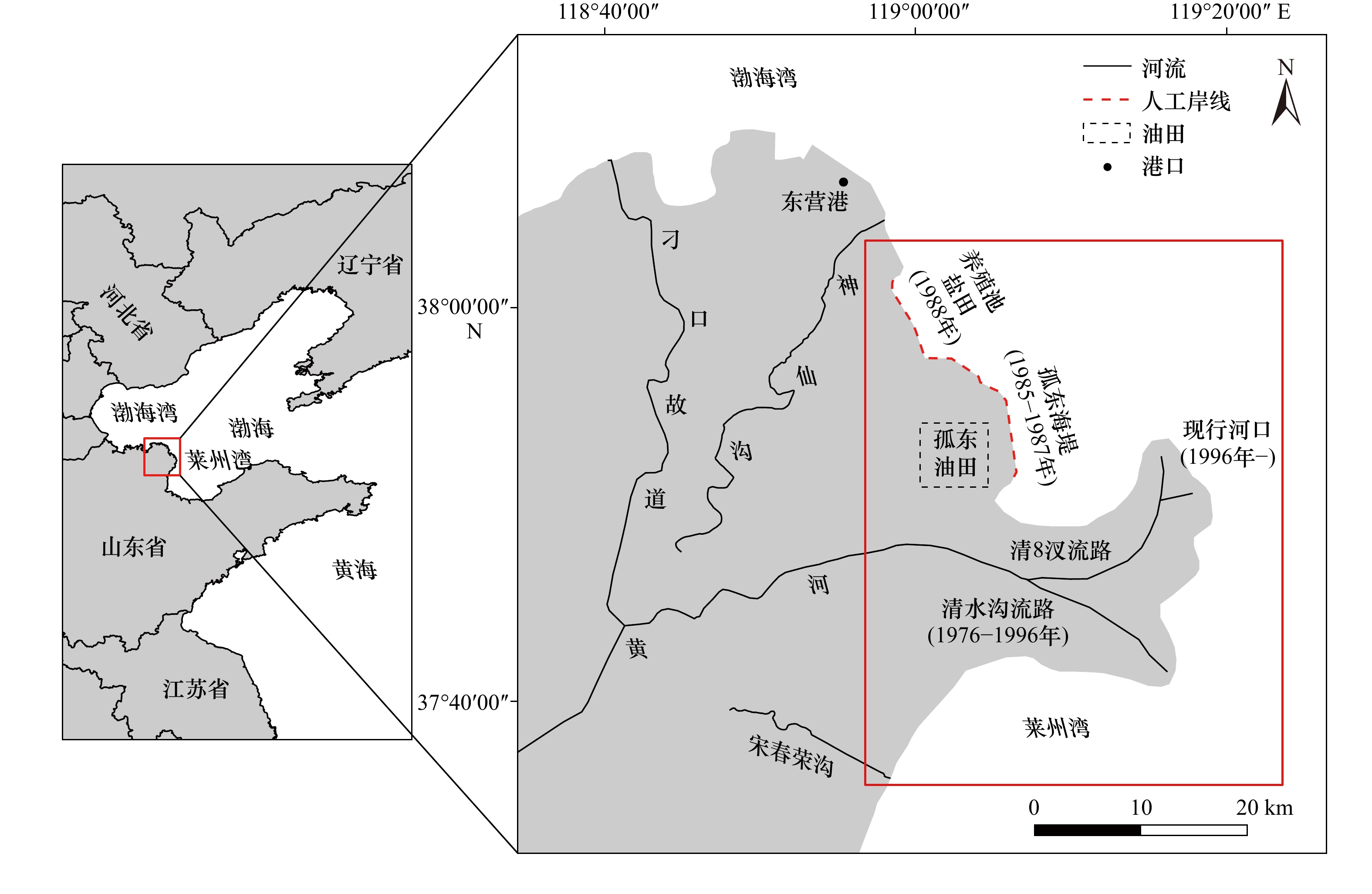
The development and evolution of the coastline of the Qingshuigou sub-delta in the Huanghe River under the background of reduced sediment discharge into the sea
-
摘要: 三角洲岸线的变迁是研究地貌冲淤最直接的要素。黄河三角洲是世界上发育最快的三角洲,研究其海岸线变化规律和演化趋势对地区生态环境保护、海洋资源开发、基础设施建设等至关重要。本文在前人研究的基础上,采用修正归一化水体指数(Modified Normalized Difference Water Index, MNDWI)与多年水频率指数(Multi-year Water Frequency Index, MWFI)相结合的方法对1976–2021年期间典型年份的207幅遥感影像进行岸线提取,使获取到的海岸线更具科学性和代表性,并在此基础上通过定量计算分析了海岸线的时空演变及其稳定性特征,以此探讨黄河清水沟亚三角洲海岸线自1976年以来的演化机制。研究结果表明:(1)总体上,清水沟亚三角洲海岸线演化呈现先快速向海淤积后波动稳定的趋势,以1996年和2002年为节点划分为“快速发育” “缓慢发育” “动态平衡”3个阶段;(2)45年来,研究区海岸线稳定性持续增强,其中孤东海堤段岸线与黄河清水沟亚三角洲南部岸线保持相对稳定,而清8汊河口段岸线与清水沟废弃河口段岸线较为活跃,其岸线稳定性指数基本低于0.5;(3)陆上三角洲淤积、侵蚀中心的迁移同河口位置变动相对应,尤其是淤积中心的迁移与河口位置变动之间在经度向存在明显的正向关系,R2 = 0.690 4;(4)黄河入海泥沙减少、河口位置迁移以及人类活动对三角洲海岸线的发育演化影响显著。从长远来看,在黄河入海泥沙持续减少的背景下,三角洲的未来仍面临侵蚀的威胁。Abstract: The shoreline change is the most direct factor in studying landform erosion and deposition. The Huanghe River Delta is the world’s fastest-growing delta, and understanding its coastline changes and evolution trends is crucial to regional ecological environment protection, marine resource development, and infrastructure construction. In this study, we combined modified normalized difference water index (MNDWI) and multi-year water frequency index (MWFI) to analyze water quality in typical years from 1976 to 2021, based on previous research. We visually interpreted 207 remote sensing images to obtain an annual coastline that makes the obtained coastline more scientific and representative. We then analyzed the temporal and spatial evolution and stability characteristics of the coastline through quantitative calculations to explore the Qingshuigou sub-delta coastline of the Yellow River’s evolution mechanism since 1976. Our main findings are as follows: (1) In general, the evolution of Qingshuigou sub-delta coastline shows a trend of rapid sedimentation towards the sea, followed by fluctuations and stability. We can divide it into “rapid development” and “slow development,” with the “dynamic equilibrium” in between, taking 1996 and 2002 as nodes. (2) Over the past 45 years, the stability of the coastline in the study area has continued to increase. The coastline of the section of the coastline and the abandoned estuary section of Qingshuigou is relatively active, and its coastline stability index is generally lower than 0.5. (3) The migration of the sedimentation and erosion center of the land delta corresponds to the estuary location’s change, especially the migration of the sedimentation center, which has a positive relationship in the longitude direction between the change of the estuary position and the position of the estuary, R2 = 0.690 4. (4) The Huanghe River’s sediment reduction into the sea, the relocation of the estuary position, and human activities have a significant impact on the delta coastline’s development and evolution. In the long run, the Huanghe River’s silt into the sea is still continuously reducing, and the future of the delta is still facing the threat of erosion.
-
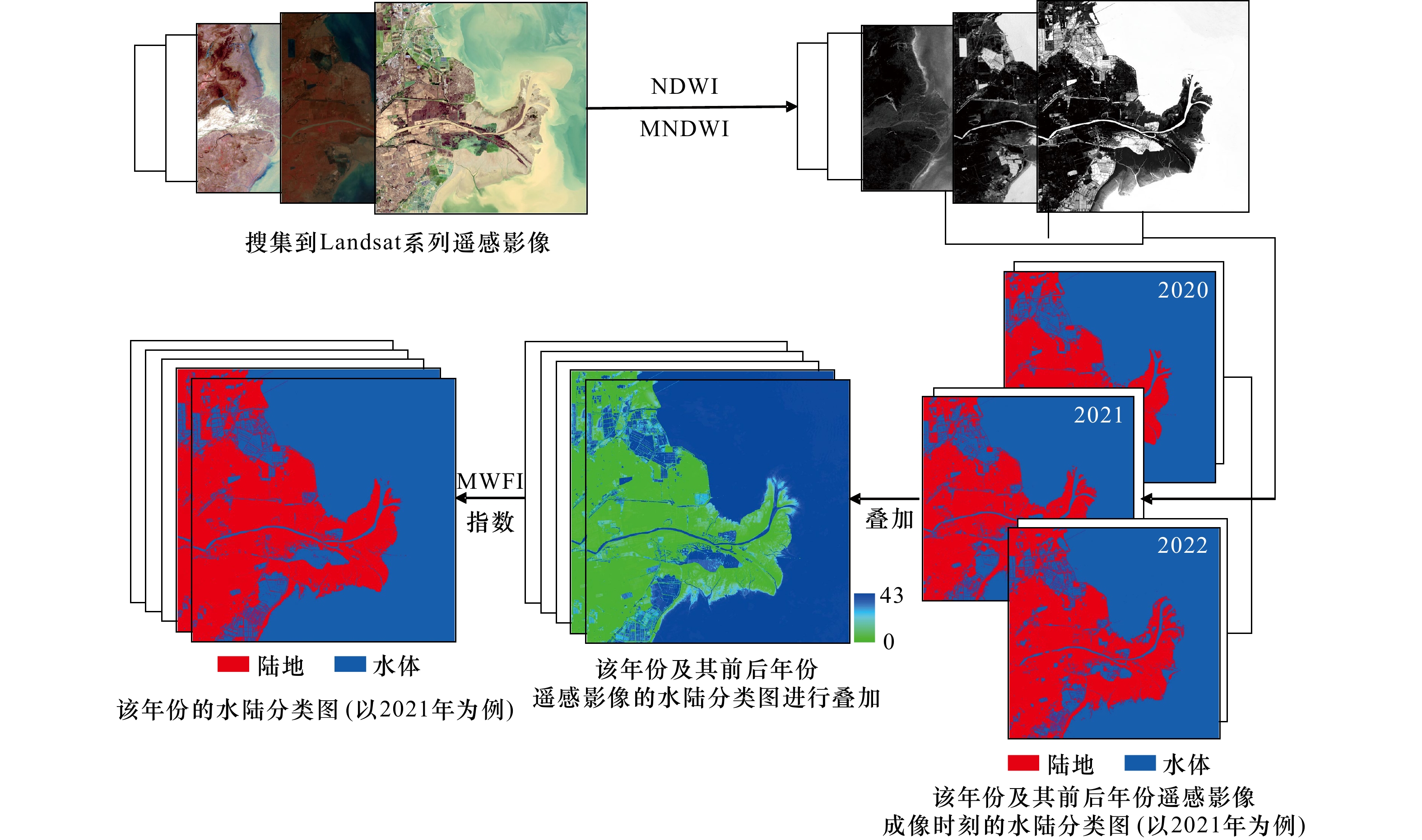
图 3 年度水陆分类图制作流程(以2021年为例)
Fig. 3 Flowchart for making annual water and land classification map (taking 2021 as example)

图 4 1976–2021年海岸线(a)与数字岸线分析参数说明(b)(a中红框为图b位置)
Fig. 4 Coastline map from 1976 to 2021 (a) and digital shoreline analysis parameter description (b) (the red box in a is the position of b)
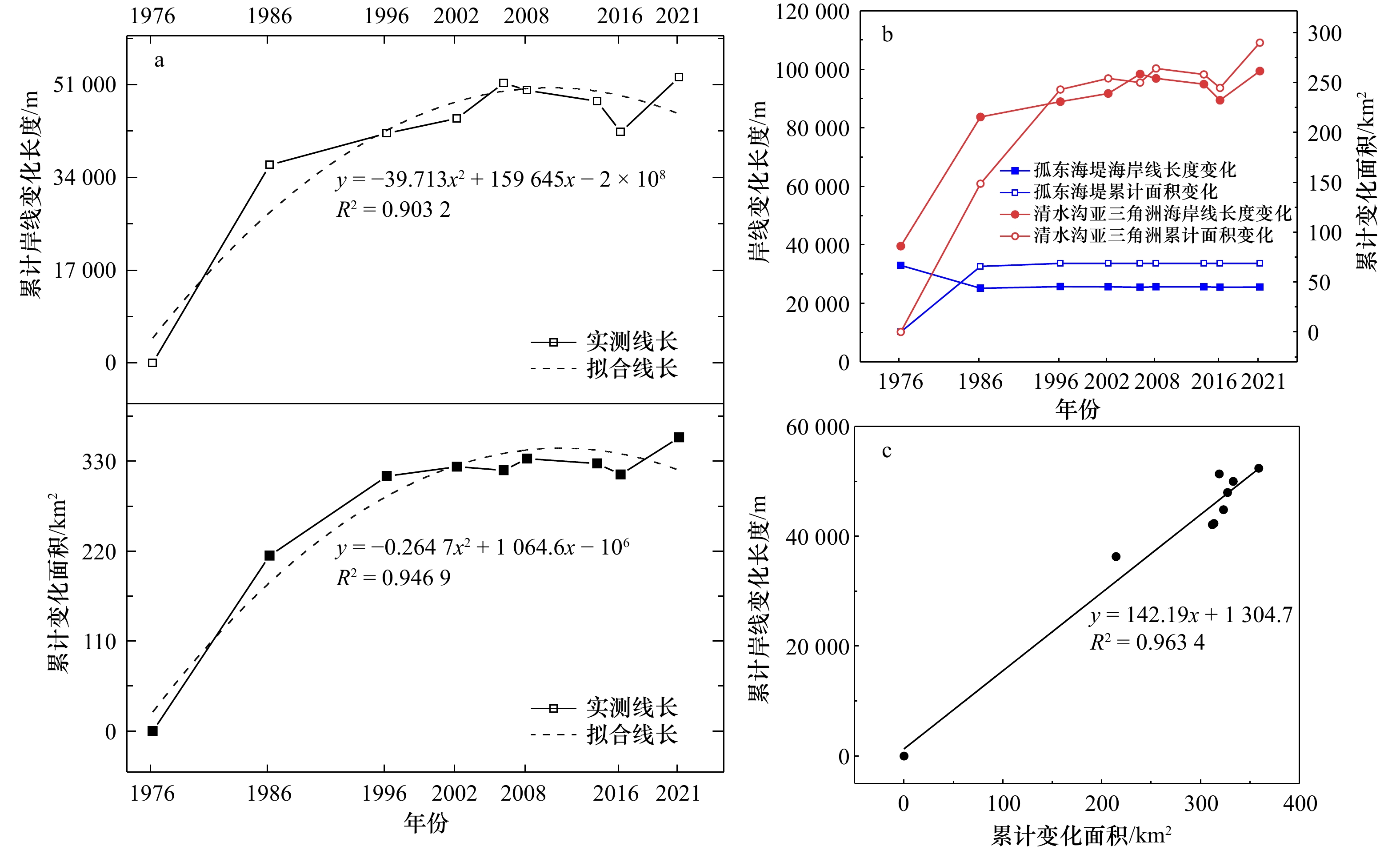
图 5 累计岸线变化长度与三角洲变化面积(a),不同岸段岸线长度变化与三角洲面积变化(b),三角洲变化面积与岸线变化长度的相关性(c)
Fig. 5 Cumulative changes of coastline length and delta area (a), changes of coastline length and delta area in different coastal segments (b), correlation between changes of delta area and coastline length (c)
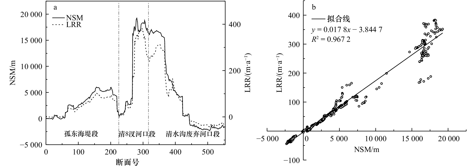
图 6 1976–2021年研究区海岸线移动距离(NSM)与岸线侵蚀速率(LRR)折线图(a)及NSM与LRR关系(b)
Fig. 6 Line chart of net shoreline movement (NSM) and littoral recession rate (LRR) in the study area from 1976 to 2021 (a), and the relationship between NSM and LRR (b)
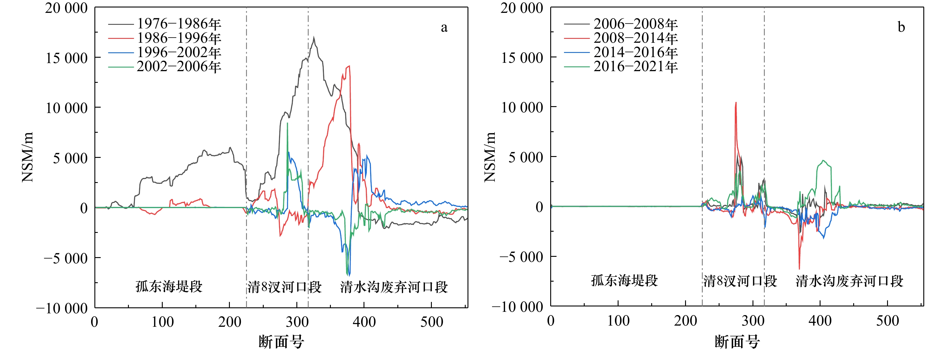
图 7 各岸段不同时期净海岸线移动距离(NSM)折线图
Fig. 7 Net shoreline movement (NSM) of each coastal segment in different periods
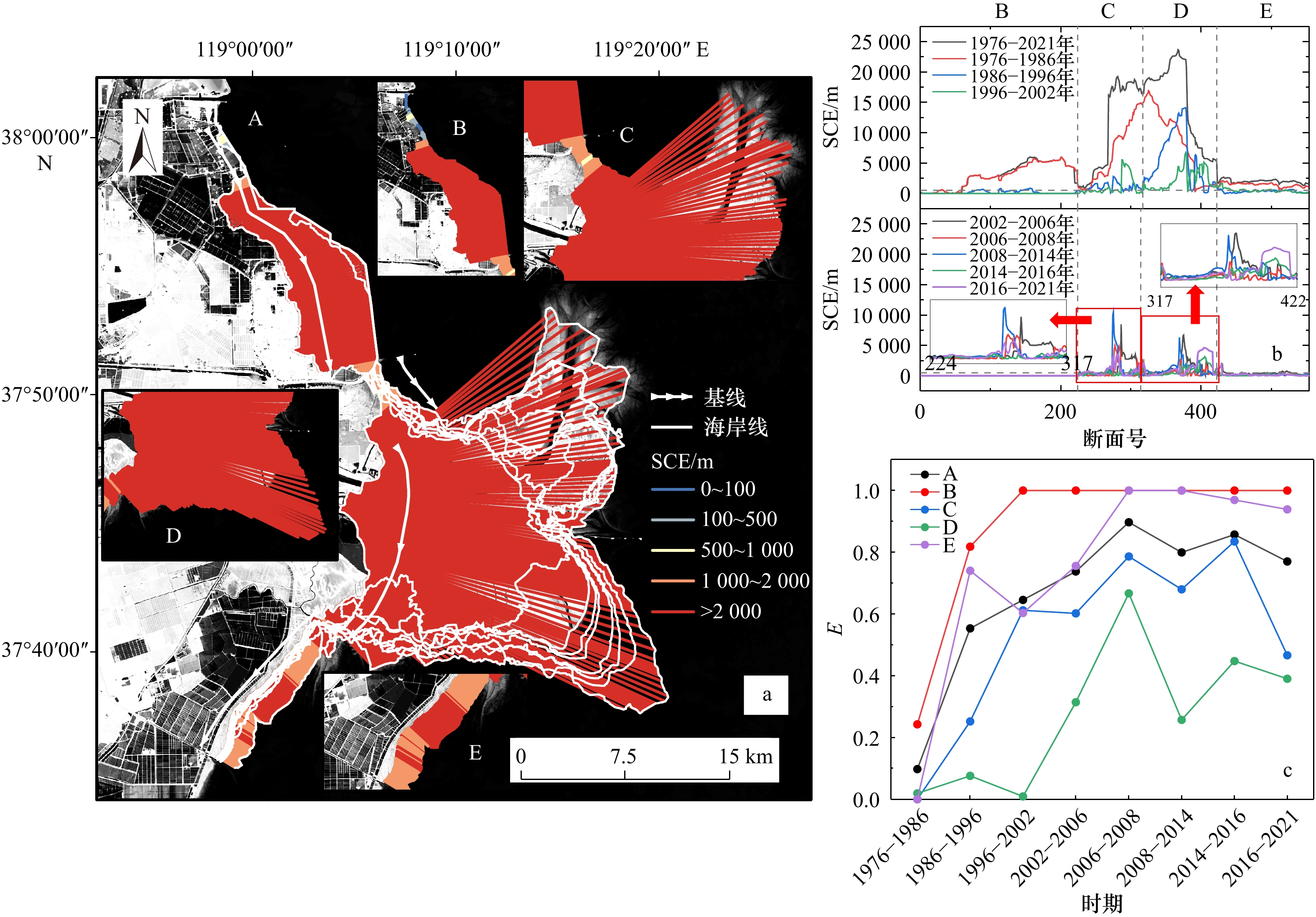
图 8 1976–2021年不同岸段岸线变化距离(SCE)空间分布(a),不同时期各岸段SCE折线图(b),不同岸段不同时期岸线稳定性指数(E)变化(c)
Fig. 8 The spatial distribution of shoreline change envelope (SCE) in different coastal segments from 1976 to 2021 (a), the SCE line of each coastal segment in different periods (b), and coastline stability index (E) variation chart (c)

图 9 陆上三角洲淤积中心(a)与侵蚀中心(b)的空间分布及变迁
背景为不同时期陆上三角洲变化面积,箭头表示淤积/侵蚀中心的迁移
Fig. 9 Spatial distribution and change of onshore delta deposition center (a) and erosion center (b)
The background is the changing area of onshore delta in different periods and the arrows in the figure represent the migration of the deposition/erosion center
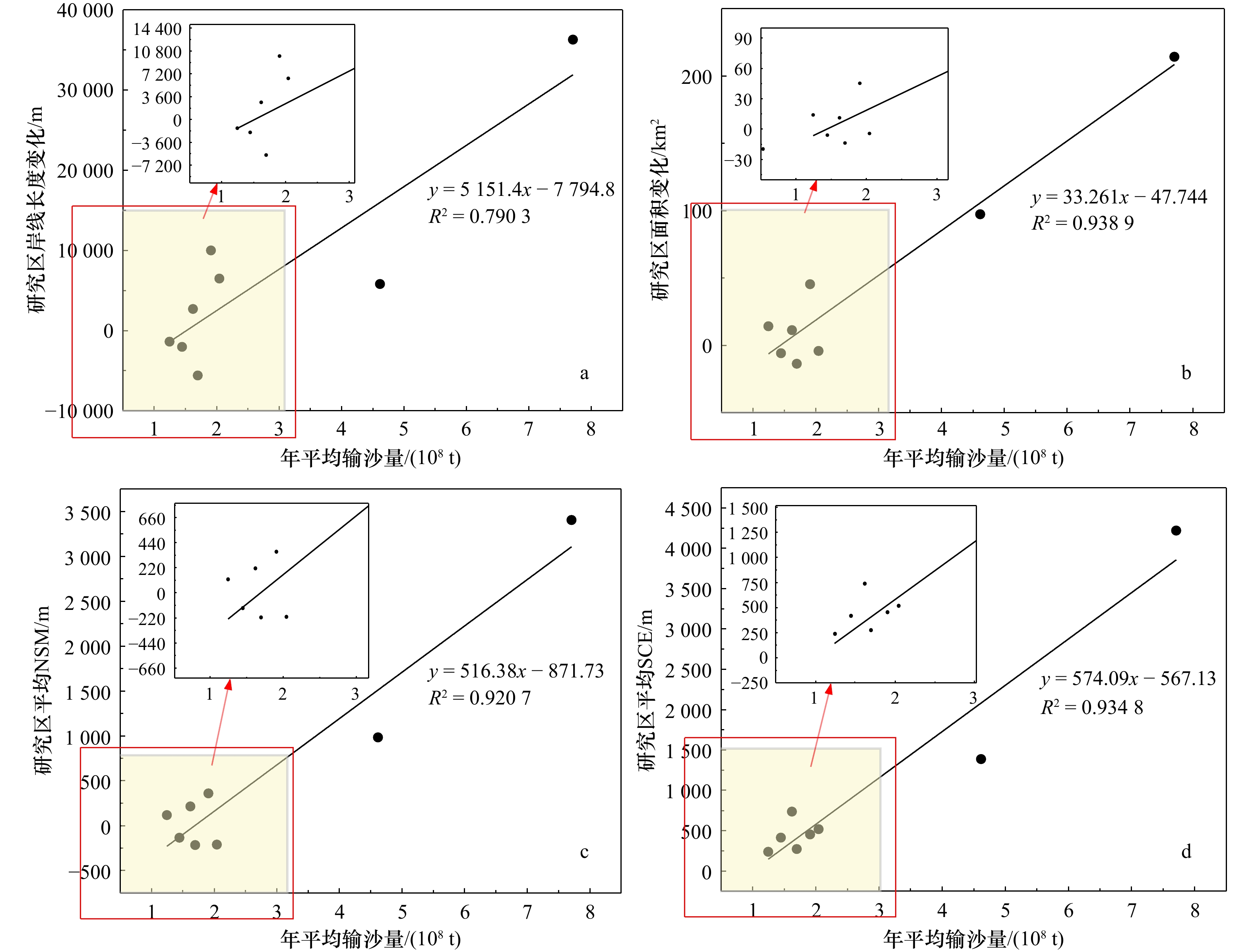
图 10 各时期年均输沙量同岸线长度变化的关系(a),同面积变化的关系(b),同平均净岸线移动距离(NSM)的关系(c),同平均海岸线变化距离(SCE)的关系(d)
Fig. 10 The relationship between the average annual sediment load and the change of shoreline length in each period (a), the relationship with the area change (b), the relationship with the average net shoreline movement (NSM , c), and the relationship with the average shoreline change envelope (SCE, d)
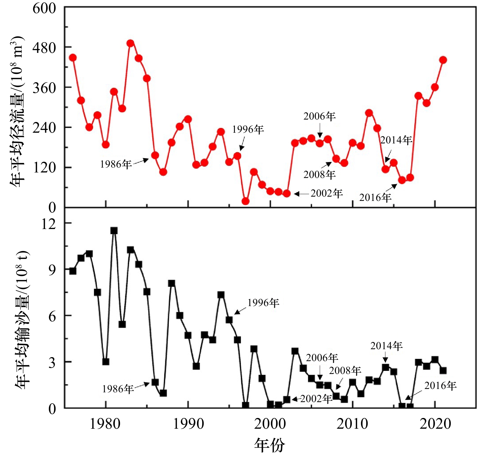
图 11 利津水文站1976–2021年年径流量和年输沙量变化
Fig. 11 Changes in annual runoff and annual sediment load at Lijin Hydrological Station from 1976 to 2021
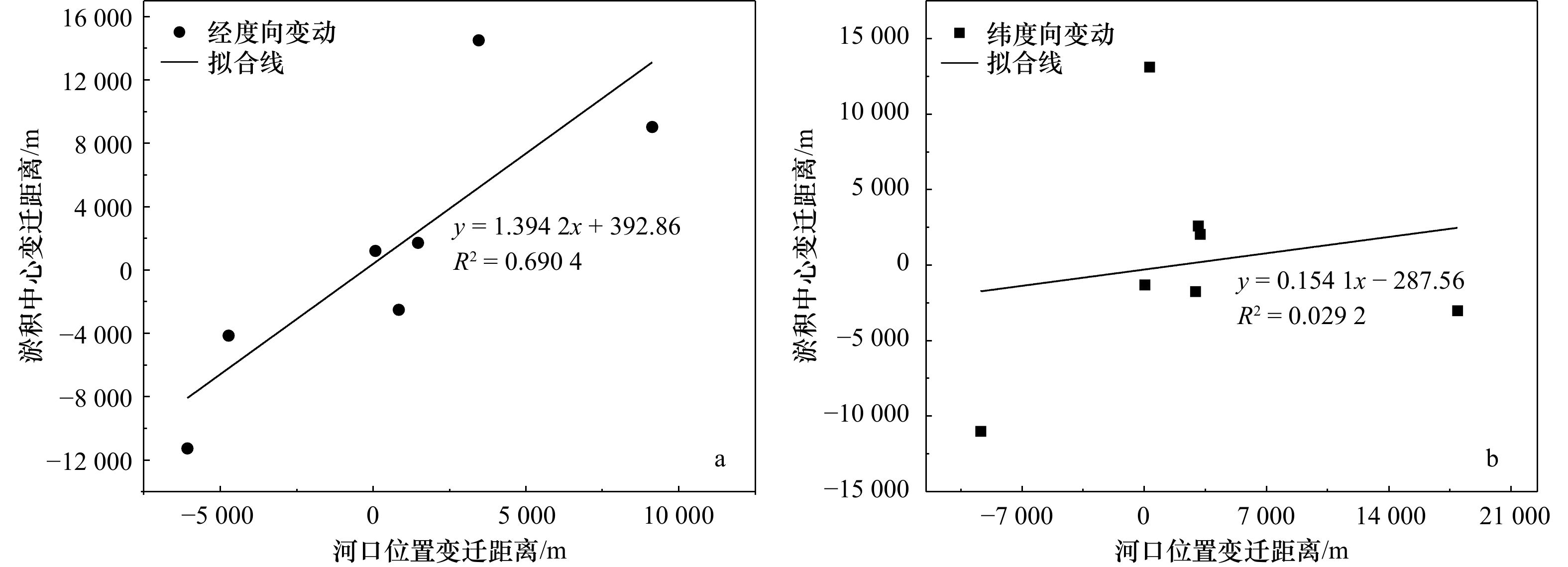
图 12 河口位置变迁距离与淤积中心经度向(a)和纬度向(b)变迁距离的关系
Fig. 12 The relationship between the change distance of the estuary position and the longitude (a) and latitude (b) change distance of the siltation center
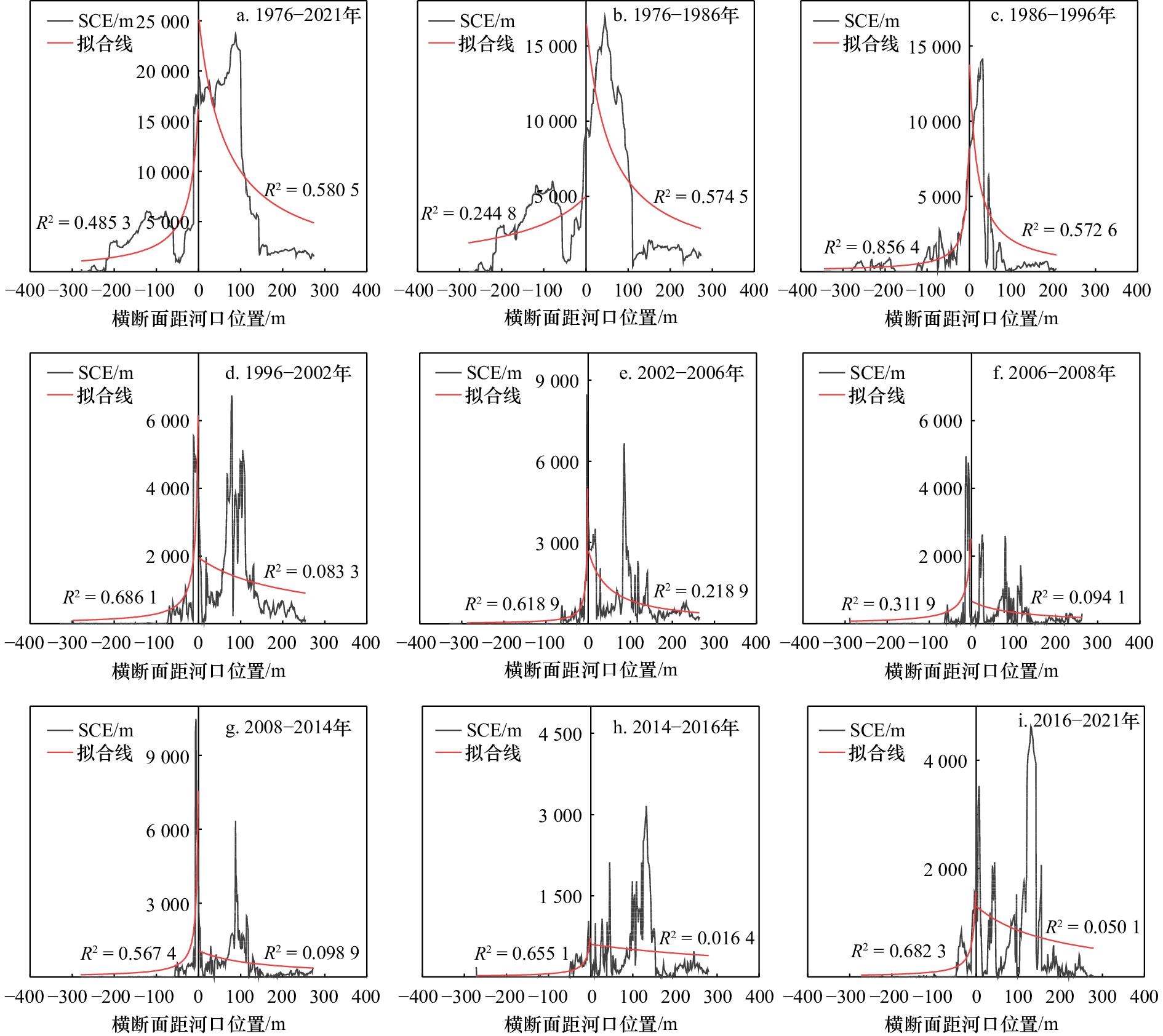
图 13 不同时期海岸线变化距离(SCE)距河口位置远近变化
Fig. 13 Changes in the distance between shoreline change envelope (SCE) and the mouth of the river in different periods
表 1 海岸线稳定性分区划分标准
Tab. 1 Division criteria of coastline stability zoning
分类标准 极稳定区 稳定区 较活跃区 活跃区 极活跃区 SCE/m 0~100 100~500 500~1 000 1 000~2 000 > 2 000  下载: 导出CSV
表 2 不同岸段不同时期岸线移动距离及其变化率
Tab. 2 The coastline movement distance and its change rate of different coast segments in different periods
研究区域 时间 平均移动距离/m 最大移动距离/m 最小移动距离/m 平均变化率/(m·a–1) 最大变化率/(m·a–1) 最小变化率/(m·a–1) 总研究区 1976–2021年 4 699.66 19 237.13 15.08 104.44 427.49 0.34 1976–1986年 3 407.41 16 921.08 2.94 340.74 1 692.11 0.29 1986–1996年 983.72 14 122.78 0 98.37 1 412.28 0 1996–2002年 215.14 5 540.83 0 35.86 923.47 0 2002–2006年 –210.40 8 464.43 0 –52.60 2 116.11 0 2006–2008年 118.94 4 948.06 0 59.47 2 474.03 0 2008–2014年 –133.85 10 476.48 0 –22.31 1 746.08 0 2014–2016年 –215.34 1 074.34 0 –107.67 537.17 0 2016–2021年 361.57 4 625.49 0 72.31 925.10 0 孤东海堤段 1986–1996年 52.06 887.50 0 5.21 88.75 0 1996–2002年 0.88 30.32 0 0.15 5.05 0 2002–2006年 –0.44 16.60 0 -0.11 4.15 0 2006–2008年 0.95 180.13 0 0.47 90.07 0 2008–2014年 –2.51 17.26 0 –0.42 2.88 0 2014–2016年 –0.77 132.64 0 –0.38 66.32 0 2016–2021年 1.38 22.68 0 0.28 4.54 0 清水沟亚三角洲段 1986–1996年 1 618.03 14 122.78 1.68 161.80 1 412.28 0.17 1996–2002年 361.02 5 540.83 10.20 60.17 923.47 1.70 2002–2006年 –353.35 8 464.43 3.03 –88.34 2 116.11 0.76 2006–2008年 199.28 4 948.06 0 99.64 2 474.03 0 2008–2014年 –223.28 10 476.48 0 –37.21 1 746.08 0 2014–2016年 –361.43 1 074.34 0 –180.71 537.17 0 2016–2021年 606.81 4 625.49 1.45 121.36 925.10 0.29
下载: 导出CSV
表 3 不同岸段不同时期海岸线纵深度年均变化速度(SY)与岸线稳定性指数(E)
Tab. 3 Average annual shorline relocation speed (SY) and coastline stability index (E) of different coastal segments in different periods
指标 岸段 1976–2021年 1976–1986年 1986–1996年 1996–2002年 2002–2006年 2006–2008年 2008–2014年 2014–2016年 2016–2021年 SY/(m·a−1) A 141.52 422.05 138.78 123.13 129.59 119.73 69.20 137.30 90.93 B 66.55 286.92 19.42 0.67 0.25 0.94 0.71 0.74 0.71 C 222.35 633.32 95.94 169.95 250.97 334.63 154.94 154.43 148.58 D 335.91 836.50 553.09 379.09 298.82 233.51 186.24 473.00 281.37 E 44.62 144.48 35.39 81.19 109.82 53.64 19.88 77.84 40.34 E A 0.10 0.10 0.55 0.65 0.74 0.90 0.80 0.86 0.77 B 0.25 0.24 0.82 1.00 1.00 1.00 1.00 1.00 1.00 C 0.00 0.00 0.25 0.61 0.60 0.79 0.68 0.83 0.47 D 0.00 0.02 0.08 0.01 0.31 0.67 0.26 0.45 0.39 E 0.00 0.00 0.74 0.60 0.76 1.00 1.00 0.97 0.94
下载: 导出CSV
-
[1] Small C, Sousa D, Yetman G, et al. Decades of urban growth and development on the Asian megadeltas[J]. Global and Planetary Change, 2018, 165: 62−89. doi: 10.1016/j.gloplacha.2018.03.005 [2] Laignel B, Vignudelli S, Almar R, et al. Observation of the coastal areas, estuaries and deltas from space[J]. Surveys in Geophysics, 2023, 44(5): 1309−1356. [3] Zhang Xuan, Fang Changling, Wang Yuan, et al. Review of effects of dam construction on the ecosystems of river estuary and nearby marine areas[J]. Sustainability, 2022, 14(10): 5974. doi: 10.3390/su14105974 [4] Kong Dongxian, Miao Chiyuan, Borthwick A G L, et al. Evolution of the Yellow River Delta and its relationship with runoff and sediment load from 1983 to 2011[J]. Journal of Hydrology, 2015, 520: 157−167. doi: 10.1016/j.jhydrol.2014.09.038 [5] Liu Zhengjia, Xu Nan, Wang Jieyong. Satellite-observed evolution dynamics of the Yellow River Delta in 1984–2018[J]. IEEE Journal of Selected Topics in Applied Earth Observations and Remote Sensing, 2020, 13: 6044−6050. doi: 10.1109/JSTARS.2020.3026708 [6] Wang Houjie, Wu Xiao, Bi Naishuang, et al. Impacts of the dam-orientated water-sediment regulation scheme on the lower reaches and delta of the Yellow River (Huanghe): a review[J]. Global and Planetary Change, 2017, 157: 93−113. doi: 10.1016/j.gloplacha.2017.08.005 [7] Xu Xuegong, Chen Zhengxiong, Feng Zhe. From natural driving to artificial intervention: changes of the Yellow River estuary and delta development[J]. Ocean & Coastal Management, 2019, 174: 63−70. [8] Wang Shuai, Fu Bojie, Piao Shilong, et al. Reduced sediment transport in the Yellow River due to anthropogenic changes[J]. Nature Geoscience, 2016, 9(1): 38−41. doi: 10.1038/ngeo2602 [9] Li Chengming, Zhu Lining, Dai Zhaoxin, et al. Study on spatiotemporal evolution of the Yellow River Delta coastline from 1976 to 2020[J]. Remote Sensing, 2021, 13(23): 4789. doi: 10.3390/rs13234789 [10] Wang Guoyang, Li Peng, Li Zhenhong, et al. Coastal dam inundation assessment for the Yellow River Delta: measurements, analysis and scenario[J]. Remote Sensing, 2020, 12(21): 3658. doi: 10.3390/rs12213658 [11] Wang Kuifeng. Evolution of Yellow River Delta coastline based on remote sensing from 1976 to 2014, China[J]. Chinese Geographical Science, 2019, 29(2): 181−191. doi: 10.1007/s11769-019-1023-5 [12] Zhu Quantao, Li Peng, Li Zhenhong, et al. Spatiotemporal changes of coastline over the Yellow River Delta in the previous 40 years with optical and SAR remote sensing[J]. Remote Sensing, 2021, 13(10): 1940. doi: 10.3390/rs13101940 [13] Liu Yubin, Li Xiaowei, Hou Xiyong. Spatiotemporal changes to the river channel and shoreline of the Yellow River Delta during a 40-Year Period (1976–2017)[J]. Journal of Coastal Research, 2020, 36(1): 128−138. [14] Zhang Xiaodong, Zhang Yexin, Ji Yang, et al. Shoreline change of the Northern Yellow River (Huanghe) Delta after the latest deltaic course shift in 1976 and its influence factors[J]. Journal of Coastal Research, 2016, 74: 48−58. doi: 10.2112/SI74-005.1 [15] Zhan Chao, Wang Qing, Cui Buli, et al. The morphodynamic difference in the western and southern coasts of Laizhou Bay: responses to the Yellow River Estuary evolution in the recent 60 years[J]. Global and Planetary Change, 2020, 187: 103138. doi: 10.1016/j.gloplacha.2020.103138 [16] Fu Yutao, Chen Shenliang, Ji Hongyu, et al. The modern Yellow River Delta in transition: causes and implications[J]. Marine Geology, 2021, 436: 106476. doi: 10.1016/j.margeo.2021.106476 [17] Bi Naishuang, Wang Houjie, Wu Xiao, et al. Phase change in evolution of the modern Huanghe (Yellow River) Delta: process, pattern, and mechanisms[J]. Marine Geology, 2021, 437: 106516. doi: 10.1016/j.margeo.2021.106516 [18] Cui Buli, Li Xiaoyan. Coastline change of the Yellow River Estuary and its response to the sediment and runoff (1976–2005)[J]. Geomorphology, 2011, 127(1/2): 32−40. [19] Wang Suiji, Hassan M A, Xie Xiaoping. Relationship between suspended sediment load, channel geometry and land area increment in the Yellow River Delta[J]. Catena, 2006, 65(3): 302−314. doi: 10.1016/j.catena.2006.01.003 [20] Gao Wei, Du Jun, Gao Shan, et al. Shoreline change due to global climate change and human activity at the Shandong Peninsula from 2007 to 2020[J]. Frontiers in Marine Science, 2023, 10: 1123067. [21] Toure S, Diop O, Kpalma K, et al. Shoreline detection using optical remote sensing: a review[J]. ISPRS International Journal of Geo-Information, 2019, 8(2): 75. doi: 10.3390/ijgi8020075 [22] Hu Ruirui, Yao Lijun, Yu Jing, et al. Remote sensing of the coastline variation of the Guangdong–Hongkong–Macao Greater Bay Area in the past four decades[J]. Journal of Marine Science and Engineering, 2021, 9(12): 1318. doi: 10.3390/jmse9121318 [23] Fan Yaoshen, Chen Shenliang, Zhao Bo, et al. Shoreline dynamics of the active Yellow River Delta since the implementation of water-sediment regulation scheme: a remote-sensing and statistics-based approach[J]. Estuarine, Coastal and Shelf Science, 2018, 200: 406−419. doi: 10.1016/j.ecss.2017.11.035 [24] Xu Nan. Detecting coastline change with all available landsat data over 1986–2015: a case study for the State of Texas, USA[J]. Atmosphere, 2018, 9(3): 107. doi: 10.3390/atmos9030107 [25] Quang D N, Ngan V H, Tam H S, et al. Long-term shoreline evolution using DSAS technique: a case study of Quang Nam Province, Vietnam[J]. Journal of Marine Science and Engineering, 2021, 9(10): 1124. doi: 10.3390/jmse9101124 [26] Li Peng, Ke Yinghai, Wang Dawei, et al. Human impact on suspended particulate matter in the Yellow River Estuary, China: Evidence from remote sensing data fusion using an improved spatiotemporal fusion method[J]. Science of the Total Environment, 2021, 750: 141612. doi: 10.1016/j.scitotenv.2020.141612 [27] Chu Zhongxin, Sun X G, Zhai Shikui, et al. Changing pattern of accretion/erosion of the modern Yellow River (Huanghe) subaerial delta, China: based on remote sensing images[J]. Marine Geology, 2006, 227(1/2): 13−30. [28] Nienhuis J H, Ashton A D, Edmonds D A, et al. Global-scale human impact on delta morphology has led to net land area gain[J]. Nature, 2020, 577(7791): 514−518. doi: 10.1038/s41586-019-1905-9 [29] Fan Yaoshen, Chen Shenliang, Pan Shunqi, et al. Storm-induced hydrodynamic changes and seabed erosion in the littoral area of Yellow River Delta: a model-guided mechanism study[J]. Continental Shelf Research, 2020, 205: 104171. doi: 10.1016/j.csr.2020.104171 [30] Ji Hongyu, Chen Shenliang, Pan Shunqi, et al. Morphological variability of the active Yellow River mouth under the new regime of riverine delivery[J]. Journal of Hydrology (Amsterdam), 2018, 564: 329−341. doi: 10.1016/j.jhydrol.2018.07.014 [31] Wu Xiao, Wang Houjie, Bi Naishuang, et al. Climate and human battle for dominance over the Yellow River’s sediment discharge: From the Mid-Holocene to the Anthropocene[J]. Marine Geology, 2020, 425: 106188. doi: 10.1016/j.margeo.2020.106188 [32] Li Peng, Ke Yinghai, Bai Junhong, et al. Spatiotemporal dynamics of suspended particulate matter in the Yellow River Estuary, China during the past two decades based on time-series Landsat and Sentinel-2 data[J]. Marine Polluttion Bulletin, 2019, 149: 110518. doi: 10.1016/j.marpolbul.2019.110518 [33] 缪红兵, 乔璐璐, 仲毅, 等. 人类活动和自然演变共同驱动下黄河三角洲海域潮波及物质输运变化[J]. 海洋学报, 2022, 44(9): 73−86.Miao Hongbing, Qiao Lulu, Zhong Yi, et al. Evolution of tidal system and material transport off the Huanghe River Delta induced by human activities and natural evolution[J]. Haiyang Xuebao, 2022, 44(9): 73−86. [34] 褚言皓, 吴文娟, 李鹏, 等. 黄河口悬浮泥沙时空动态及其驱动机制[J]. 海洋学报, 2022, 44(6): 150−163.Chu Yanhao, Wu Wenjuan, Li Peng, et al. Temporal and spatial dynamics of suspended sediment and its driving mechanism in the Yellow River Estuary[J]. Haiyang Xuebao, 2022, 44(6): 150−163. [35] 姬泓宇. 新入海水沙情势下黄河三角洲地貌动态变化与演变机制[D]. 上海: 华东师范大学, 2021.Ji Hongyu. Morphological variability of the Yellow River Delta and its dynamic mechanism under the new regime of river delivery[D]. Shanghai: East China Normal University, 2021. [36] 徐涵秋. 利用改进的归一化差异水体指数(MNDWI)提取水体信息的研究[J]. 遥感学报, 2005, 9(5): 589−595.Xu Hanqiu. A study on information extraction of water body with the modified normalized difference water index (MNDWI)[J]. Journal of Remote Sensing, 2005, 9(5): 589−595. [37] Yang Haibo, Li Yunfei, Wei Jiahua. Yellow River Estuary Coastline change analysis before and after the water and sediment regulation in 12 years[J]. Advanced Materials Research, 2014, 955−959: 3883−3886. doi: 10.4028/www.scientific.net/AMR.955-959.3883 [38] 丁小松, 单秀娟, 陈云龙, 等. 基于数字化海岸分析系统(DSAS)的海岸线变迁速率研究: 以黄河三角洲和莱州湾海岸线为例[J]. 海洋通报, 2018, 37(5): 565−575.Ding Xiaosong, Shan Xiujuan, Chen Yunlong, et al. Study on the change rate of shoreline based on Digital Coastal Analysis System (DSAS): taking the shoreline of the Yellow River Delta and Laizhou Bay as an example[J]. Marine Science Bulletin, 2018, 37(5): 565−575. [39] Apostolopoulos D, Nikolakopoulos K. A review and meta-analysis of remote sensing data, GIS methods, materials and indices used for monitoring the coastline evolution over the last twenty years[J]. European Journal of Remote Sensing, 2021, 54(1): 240−265. doi: 10.1080/22797254.2021.1904293 [40] Song Yuan, Shen Yongming, Xie Ruofan, et al. A DSAS-based study of central shoreline change in Jiangsu over 45 years[J]. Anthropocene Coasts, 2021, 4(1): 115−128. doi: 10.1139/anc-2020-0001 [41] Abou Samra R M, Ali R R. Applying DSAS tool to detect coastal changes along Nile Delta, Egypt[J]. The Egyptian Journal of Remote Sensing and Space Science, 2021, 24(3): 463−470. doi: 10.1016/j.ejrs.2020.11.002 [42] 刘鹏, 王庆, 战超, 等. 基于DSAS和FA的1959−2002年黄河三角洲海岸线演变规律及影响因素研究[J]. 海洋与湖沼, 2015, 46(3): 585−594.Liu Peng, Wang Qing, Zhan Chao, et al. Quantitative analysis of coastline change in the Yellow River Delta from 1959 to 2002[J]. Oceanologia et Limnologia Sinica, 2015, 46(3): 585−594. [43] Iskander M M. Stability of the Northern coast of Egypt under the effect of urbanization and climate change[J]. Water Science, 2021, 35(1): 1−10. doi: 10.1080/11104929.2020.1864255 [44] 张云, 张建丽, 李雪铭, 等. 1990年以来中国大陆海岸线稳定性研究[J]. 地理科学, 2015, 35(10): 1288−1293.Zhang Yun, Zhang Jianli, Li Xueming, et al. Stability of continental coastline in China since 1990[J]. Scientia Geographica Sinica, 2015, 35(10): 1288−1293. [45] Yu Xiang, Zhan Chao, Wu Mengquan, et al. An improved method for mapping tidal waterways based on remotely sensed waterlines: a case study in the Yellow River Delta, China[J]. Marine Georesources & Geotechnology, 2020, 38(8): 887−895. [46] 刘修锦, 邢容容, 邱若峰, 等. 滦河三角洲典型潟湖-沙坝海岸岸线稳定性评价[J]. 海洋环境科学, 2020, 39(3): 426−431.Liu Xiujin, Xing Rongrong, Qiu Ruofeng, et al. The stability evaluation of lagoon-barrier coastline, Luanhe Delta[J]. Marine Environmental Science, 2020, 39(3): 426−431. [47] Ji Hongyu, Chen Shenliang, Jiang Chao, et al. Damming-induced hydrogeomorphic transition in downstream channel and delta: a case study of the Yellow River, China[J]. Water, 2022, 14(13): 2079. doi: 10.3390/w14132079 [48] Wang Houjie, Yang Zuosheng, Saito Y, et al. Stepwise decreases of the Huanghe (Yellow River) sediment load (1950–2005): impacts of climate change and human activities[J]. Global and Planetary Change, 2007, 57(3/4): 331−354. [49] Wu Xiao, Bi Naishuang, Syvitski J, et al. Can reservoir regulation along the Yellow River be a sustainable way to save a sinking delta?[J]. Earth’s Future, 2020, 8(11): e2020EF001587. doi: 10.1029/2020EF001587 [50] 陈沈良, 谷硕, 姬泓宇, 等. 新入海水沙情势下黄河口的地貌演变[J]. 泥沙研究, 2019, 44(5): 60−66.Chen Shenliang, Gu Shuo, Ji Hongyu, et al. Processes of the Yellow River Mouth on new water and sediment condition[J]. Journal of Sediment Research, 2019, 44(5): 60−66. [51] 胥维坤. 小浪底水库运行后黄河下游水沙及其三角洲动力沉积演变[D]. 上海: 华东师范大学, 2016.Xu Weikun. The evolution of water and sediment in lower Yellow River and dynamic geomorphology in Yellow River Delta to water-sediment modulation[D]. Shanghai: East China Normal University, 2016. [52] 刘大海, 陈小英, 徐伟, 等. 1985年以来黄河三角洲孤东海岸演变与生态损益分析[J]. 生态学报, 2014, 34(1): 115−121.Liu Dahai, Chen Xiaoying, Xu Wei, et al. Analysis of the evolution and value of coastal ecosystem services at Gudong Coast in the Yellow River Delta since 1985[J]. Acta Ecologica Sinica, 2014, 34(1): 115−121. -


计量
- 文章访问数: 341
- HTML全文浏览量: 157
- PDF下载量: 60
- 被引次数: 0
