

Landsat-5 image extraction method for tidal flat waterline: Take the Chongming Dongtan, Changjiang River Estuary as an example
-
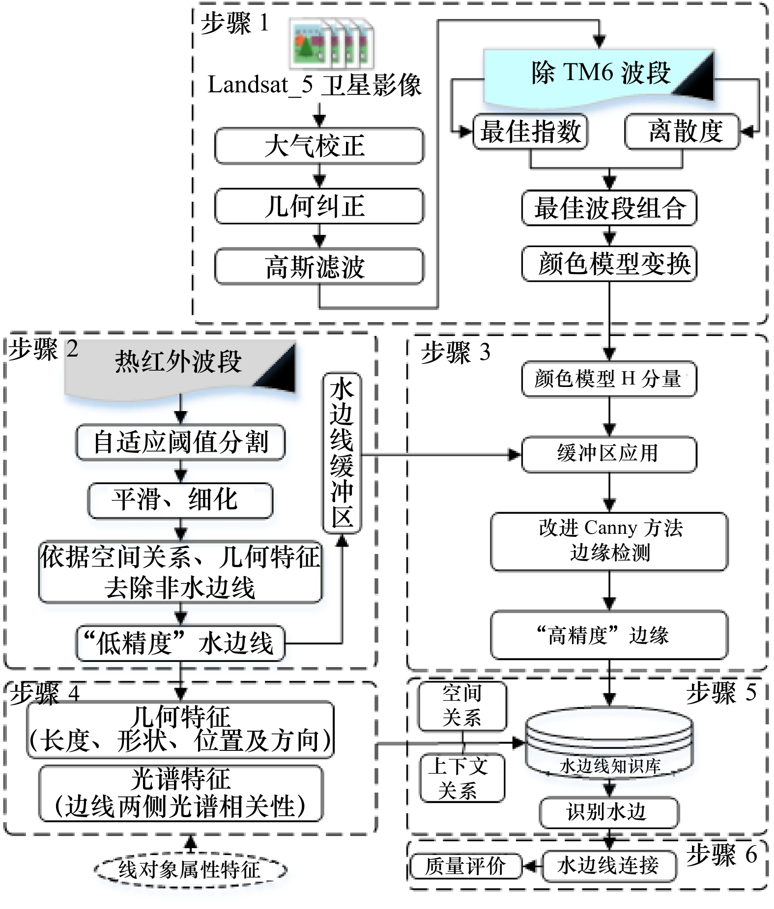
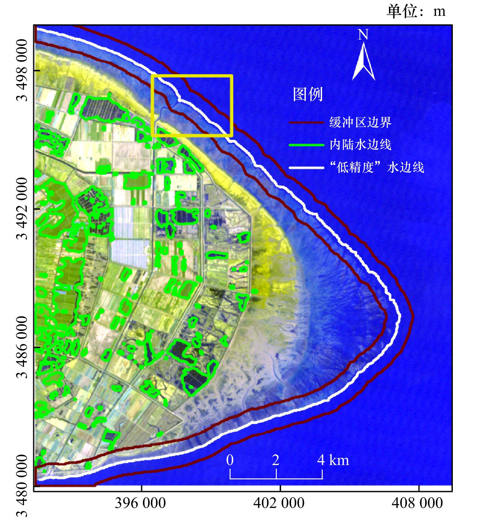
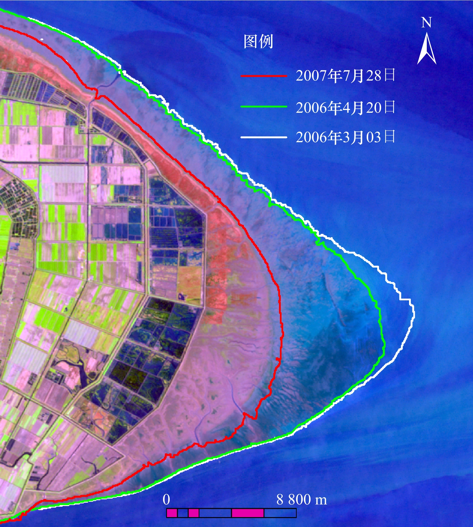
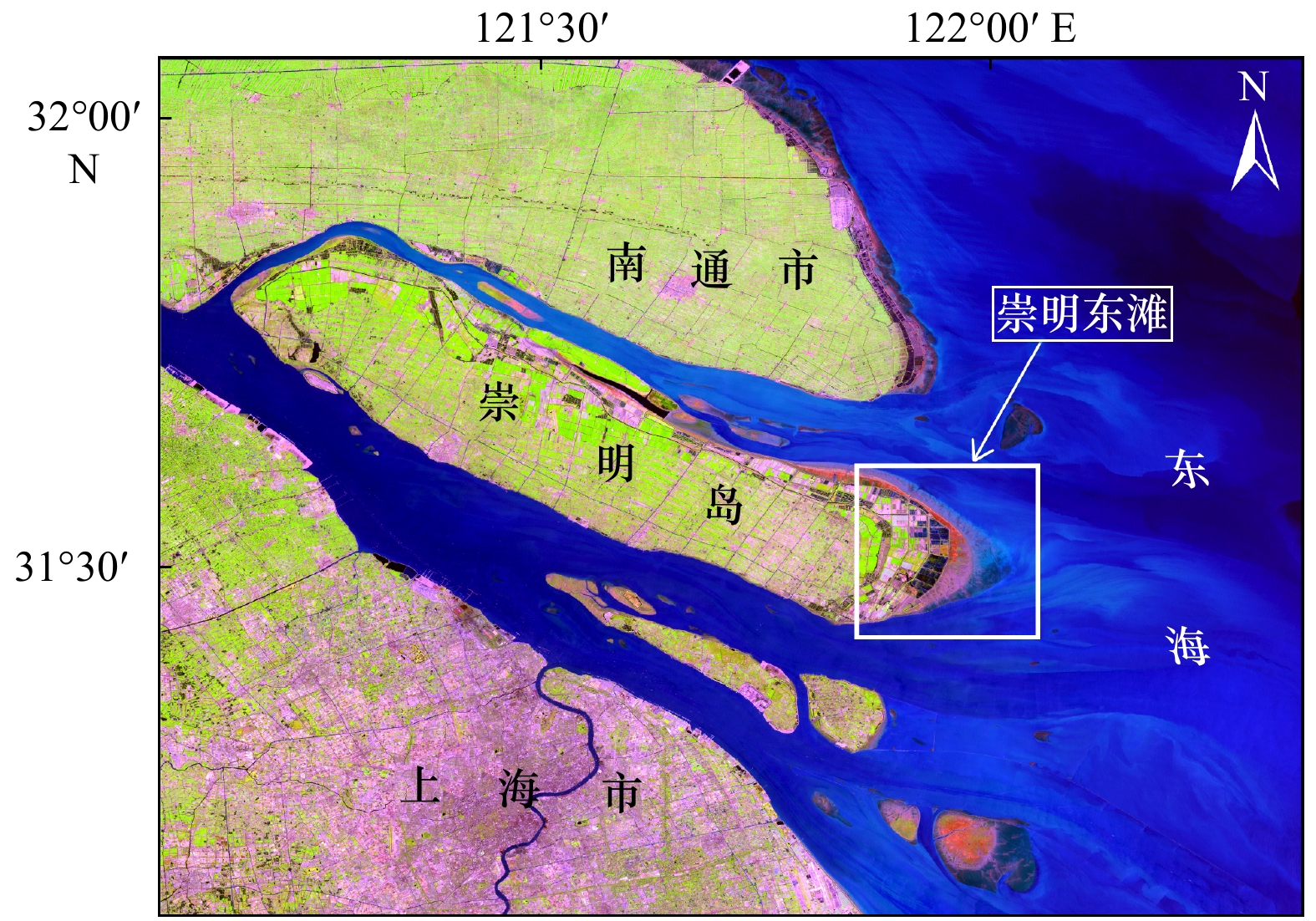
摘要: 快速获取遥感影像水边线时空变化信息具有重要意义,滩涂水边线提取一直是遥感技术应用的难点问题。水边线在遥感影像上具有独特的空间关系与光谱特征。本文综合使用颜色模型变换法、信息熵计算法、最大类间方差法及边缘检测方法。以长江口崇明东滩为研究区,研究了Landsat-5卫星影像海陆对比度增强及不同尺度下的边缘提取,重点给出了基于热红外波段的水边线空间特征与光谱特征的计算方法,在面向对象技术框架下提出了一种顾及空间关系和光谱特征的遥感影像水边线快速提取方法。实验结果表明:(1)基于最大类间方差法的局部阈值分割法能够自动提取band 6的水边线,水边线连续、完整,空间信息丰富;(2)综合使用最佳指数法、离散度方法及颜色模型变换方法,能够有效增强海陆对比度,基于最大类间方差法的局部自适应Canny算子能够自动检测出增强后遥感影像高精度边缘;(3)利用水边线的空间关系和光谱特征,能够由计算机自动实现水边线的识别与连接工作;(4)本文提出的水边线提取方法速度快、自动化程度高,分别继承了阈值分割法的连续性强的优点和Canny算子定位精度高、细节呈现能力强的优势。研究结果对于海岸带动态变化、陆海相互作用机制、海岸带资源保护与开发及近海工程管理等研究具有重要的参考价值。Abstract: It is of great significance to quickly acquire spatiotemporal change in the information of waterline of remote sensing image. The extraction of the waterline of tidal flat on the remote sensing image has always been a difficult problem in the application of remote sensing technology. There are unique spatial relationships and spectral characteristics on the remote sensing image of waterline. The research area is the Chongming Dongtan of the Changjiang River Estuary. By integrating methods of color model transformation, information entropy calculation, maximum variance and edge detection, we explored how to enhance the contrast of land and sea on the Landsat-5 satellite image, and the edge extraction at different scales was studied. The calculation method of the spatial and spectral characteristics of the waterline using the thermal infrared band was given. A fast extraction method of waterline of sensory image taking the spatial relationship and spectral characteristics into account under the framework of object-oriented technology was proposed. Results show that: (1) The local threshold segmentation method based on the maximum between-class variance method can automatically extract the waterline of band 6. The waterline is continuous, complete, and rich in spatial information. (2) The combination of the optimum index factor method, the dispersion method and the color model transformation method can effectively enhance the contrast between land and sea. The local adaptive Canny operator based on the maximum between-class variance method can automatically detect the high precision edge of the enhanced remote sensing image. (3) Using the spatial relationship and spectral characteristic of waterline, the computer can recognize and connect waterline automatically. (4) The waterline extraction method proposed in this paper is fast and automated, inheriting strong continuity of the threshold segmentation method and high positioning accuracy and strong ability to present details of Canny operator. The results have significant value for researches on the dynamic changes in the coastal zone, the mechanism of land-sea interaction, the protection and development of coastal zone resources, and offshore engineering management.
-
Key words:
- line object /
- spatial relationship /
- edge detection /
- local adaptive /
- waterline /
- tidal flat
-
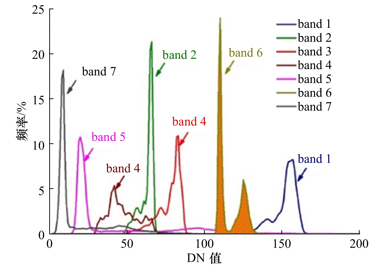
图 3 Landsat-5影像各波段DN值直方图
Fig. 3 Histogram of DN value of each band of Landsat-5 satellite image

图 5 HLS颜色模型H值密度分割结果
Fig. 5 H-value density segmentation results of the HLS color model
图 6 归一化差异水体指数密度分割结果
Fig. 6 Normalized difference water index density segmentation result
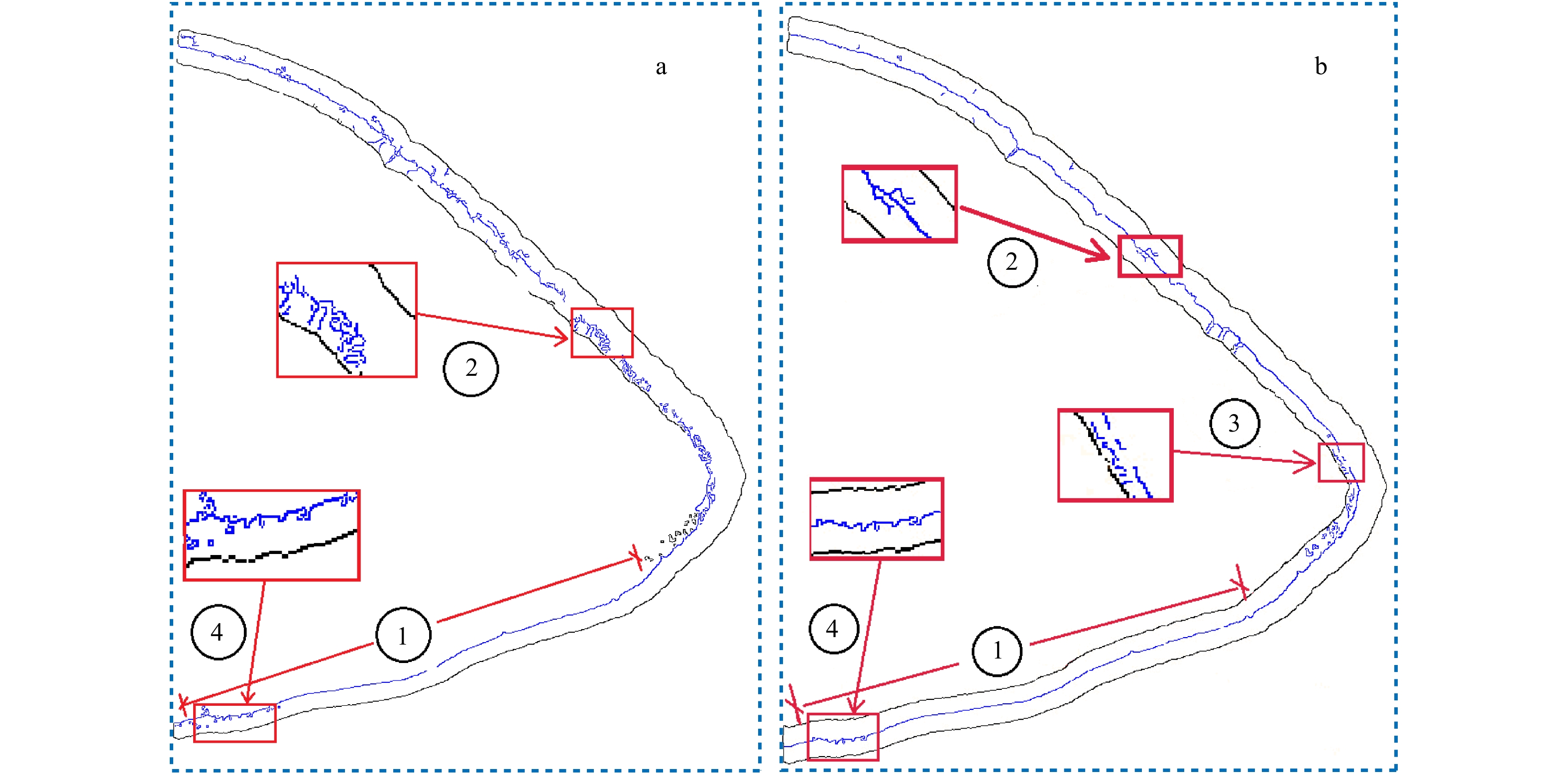
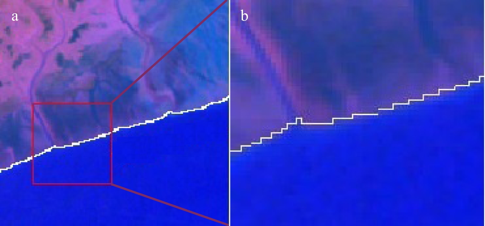
图 7 全阈值Canny算子(a)和本文方法(b)检测出的“高精度”边缘结果
Fig. 7 High-precision edge results detected by the full-threshold Canny operator (a) and the method (b) of this paper
表 1 线元对象属性计算结果(单位:像元)
Tab. 1 Line object property calculation results (unit: pixel)
编号(ID) 位置(P) 长度(L) 形状(S) 方向(A) 光谱($ \mathrm{\rho } $) 1 2.26 39 4.81 +1.27° 0.12 2 1.30 107 0.08 +0.01° 0.62 $\vdots $ $\vdots $ $\vdots $ $\vdots $ $\vdots $ $\vdots $ n 1.28 449 0.04 +0.01° 0.64  下载: 导出CSV
-
[1] 申家双, 郭海涛, 李海滨, 等. 基于Canny算子和GAC模型相结合的影像水边线提取方法[J]. 测绘科学技术学报, 2013, 30(3): 264−268. doi: 10.3969/j.issn.1673-6338.2013.03.011Shen Jiashuang, Guo Haitao, Li Haibin, et al. A water edge extraction method from images based on Canny operator and GAC model[J]. Journal of Geomatics Science and Technology, 2013, 30(3): 264−268. doi: 10.3969/j.issn.1673-6338.2013.03.011 [2] Boak E H, Turner I L. Shoreline definition and detection: a review[J]. Journal of Coastal Research, 2005, 21(4): 688−703. [3] Lee J S, Jurkevich I. Coastline detection and tracing in SAR images[J]. IEEE Transactions on Geoscience and Remote Sensing, 1990, 28(4): 662−668. doi: 10.1109/TGRS.1990.572976 [4] Addo K A, Walkden M, Mills J P. Detection, measurement and prediction of shoreline recession in Accra, Ghana[J]. ISPRS Journal of Photogrammetry and Remote Sensing, 2008, 63(5): 543−558. doi: 10.1016/j.isprsjprs.2008.04.001 [5] Liu H, Jezek K C. Automated extraction of coastline from satellite imagery by integrating Canny edge detection and locally adaptive thresholding methods[J]. International Journal of Remote Sensing, 2004, 25(5): 937−958. doi: 10.1080/0143116031000139890 [6] Mason D C, Davenport I J, Flather R A, et al. Cover a digital elevation model of the inter-tidal areas of the Wash, England, produced by the waterline method[J]. International Journal of Remote Sensing, 1998, 19(8): 1455−1460. doi: 10.1080/014311698215289 [7] 郑宗生, 周云轩, 蒋雪中, 等. 崇明东滩水边线信息提取与潮滩DEM的建立[J]. 遥感技术与应用, 2007, 22(1): 35−38, 94. doi: 10.3969/j.issn.1004-0323.2007.01.007Zheng Zongsheng, Zhou Yunxuan, Jiang Xuezhong, et al. Waterline extraction and DEM reconstruction in Chongming Dongtan[J]. Remote Sensing Technology and Application, 2007, 22(1): 35−38, 94. doi: 10.3969/j.issn.1004-0323.2007.01.007 [8] Niedermeier A, Romaneessen E, Lehner S. Detection of coastlines in SAR images using wavelet methods[J]. IEEE Transactions on Geoscience and Remote Sensing, 2000, 38(5): 2270−2281. doi: 10.1109/36.868884 [9] Li Zhen, Heygster G, Notholt J. Intertidal topographic maps and morphological changes in the German Wadden Sea between 1996−1999 and 2006−2009 from the waterline method and SAR images[J]. IEEE Journal of Selected Topics in Applied Earth Observations and Remote Sensing, 2014, 7(8): 3210−3224. doi: 10.1109/JSTARS.2014.2313062 [10] 盛佳, 洪中华, 张云, 等. 基于TerraSAR-X影像的格陵兰岛海岸水边线提取[J]. 极地研究, 2014, 26(4): 418−424.Sheng Jia, Hong Zhonghua, Zhang Yun, et al. Extraction of the Greenland coastline based on TerraSAR-X imagery[J]. Chinese Journal of Polar Research, 2014, 26(4): 418−424. [11] 刘炜, 王聪华, 赵尔平, 等. 基于面向对象分类的细小河流水体提取方法研究[J]. 农业机械学报, 2014, 45(47): 237−244.Liu Wei, Wang Conghua, Zhao Erping, et al. Extraction of small river information based on object-oriented classification[J]. Transactions of the Chinese Society for Agricultural Machinery, 2014, 45(47): 237−244. [12] Zhang Tao, Yang Xiaomei, Hu Shanshan, et al. Extraction of coastline in aquaculture coast from multispectral remote sensing images: object-based region growing integrating edge detection[J]. Remote Sensing, 2013, 5(9): 4470−4487. doi: 10.3390/rs5094470 [13] 欧阳越, 种劲松. 基于改进水平截集算法的SAR图像海岸线检测[J]. 遥感技术与应用, 2004, 19(6): 456−460. doi: 10.3969/j.issn.1004-0323.2004.06.005Ouyang Yue, Zhong Jinsong. Coastline detection method in SAR images based on an improved level set algorithm[J]. Remote Sensing Technology and Application, 2004, 19(6): 456−460. doi: 10.3969/j.issn.1004-0323.2004.06.005 [14] 郭海涛, 孙磊, 申家双, 等. 一种四叉树和测地线活动轮廓模型相结合的海陆影像分割方法[J]. 测绘学报, 2016, 45(1): 65−72.Guo Haitao, Sun Lei, Shen Jiashuang, et al. An island and coastal image segmentation method based on Quadtree and GAC model[J]. Acta Geodaetica et Cartographica Sinica, 2016, 45(1): 65−72. [15] Zhu Ziwei, Tang Yuqi, Hu Jun, et al. Coastline extraction from high-resolution multispectral images by integrating prior edge information with active contour model[J]. IEEE Journal of Selected Topics in Applied Earth Observations and Remote Sensing, 2019, 12(10): 4099−4109. doi: 10.1109/JSTARS.2019.2939297 [16] Kang Yanyan, Ding Xianrong, Xu Fan, et al. Topographic mapping on large-scale tidal flats with an iterative approach on the waterline method[J]. Estuarine, Coastal & Shelf Science, 2017, 190: 11−22. [17] 郑宗生, 周云轩, 刘志国, 等. 基于水动力模型及遥感水边线方法的潮滩高程反演[J]. 长江流域资源与环境, 2008, 17(5): 756−760. doi: 10.3969/j.issn.1004-8227.2008.05.017Zheng Zongsheng, Zhou Yunxuan, Liu Zhiguo, et al. DEM reconstruction based on hydrodynamic model and waterline method[J]. Resources and Environment in the Yangtze Basin, 2008, 17(5): 756−760. doi: 10.3969/j.issn.1004-8227.2008.05.017 [18] Dai Chunli, Howat I M, Larour E, et al. Coastline extraction from repeat high resolution satellite imagery[J]. Remote Sensing of Environment, 2019, 229: 260−270. doi: 10.1016/j.rse.2019.04.010 [19] 吴一全, 刘忠林. 遥感影像的海岸线自动提取方法研究进展[J]. 遥感学报, 2019, 23(4): 582−602.Wu Yiquan, Liu Zhonglin. Research progress on methods of automatic coastline extraction based on remote sensing images[J]. Journal of Remote Sensing, 2019, 23(4): 582−602. [20] 韩震, 恽才兴. 长江口近岸水域卫星遥感应用技术研究[M]. 北京: 海洋出版社, 2011: 32−48.Han Zhen, Yun Caixing. Research on Application Technology of Satellite Remote Sensing in Coastal Waters of Changjiang Estuary[M]. Beijing: China Ocean Press, 2011: 32−48. [21] 邓书斌, 陈秋锦, 杜会建, 等. ENVI遥感图像处理方法[M]. 2版. 北京: 高等教育出版社, 2014: 197−210.Deng Shubin, Chen Qiujin, Du Huijian, et al. ENVI Remote Sensing Image Processing Method[M]. 2nd ed. Beijing: Higher Education Press, 2014: 197−210. [22] Ryu J H, Won J S, Min K D. Waterline extraction from Landsat TM data in a tidal flat: a case study in Gomso Bay, Korea[J]. Remote Sensing of Environment, 2002, 83(3): 442−456. doi: 10.1016/S0034-4257(02)00059-7 [23] Ingle M A, Talmale G R. Respiratory mask selection and leakage detection system based on Canny edge detection operator[J]. Procedia Computer Science, 2016, 78: 323−329. doi: 10.1016/j.procs.2016.02.064 [24] 刘丽霞, 李宝文, 王阳萍, 等. 改进Canny边缘检测的遥感影像分割[J]. 计算机工程与应用, 2019, 55(12): 54−58, 180. doi: 10.3778/j.issn.1002-8331.1811-0180Liu Lixia, Li Baowen, Wang Yangping, et al. Remote sensing image segmentation based on improved Canny edge detection[J]. Computer Engineering and Applications, 2019, 55(12): 54−58, 180. doi: 10.3778/j.issn.1002-8331.1811-0180 [25] Johnson L F, Billow C R. Spectrometry estimation of total nitrogen concentration in Douglas-fir foliage[J]. International Journal of Remote Sensing, 1996, 17(3): 489−500. doi: 10.1080/01431169608949022 [26] 杨立君, 黄婷. 潮滩植被调查最佳波段组合研究[J]. 安徽农业科学, 2012, 40(4): 2514−2516, 2519. doi: 10.3969/j.issn.0517-6611.2012.04.213Yang Lijun, Huang Ting. Study on the best band combination for investigation of tidal vegetation[J]. Journal of Anhui Agricultural Sciences, 2012, 40(4): 2514−2516, 2519. doi: 10.3969/j.issn.0517-6611.2012.04.213 [27] 刘永学, 李满春, 张忍顺. 江苏辐射沙洲水边线自动提取方法研究[J]. 海洋科学, 2004, 28(6): 42−45. doi: 10.3969/j.issn.1000-3096.2004.06.010Liu Yongxue, Li Manchun, Zhang Renshun. Automatic recognition of sandbank shoreline on satellite image[J]. Marine Sciences, 2004, 28(6): 42−45. doi: 10.3969/j.issn.1000-3096.2004.06.010 -


计量
- 文章访问数: 529
- HTML全文浏览量: 149
- PDF下载量: 42
- 被引次数: 0
